The Lake
Lake, Pool, Pond, Freshwater Marsh in Dorset
England
The Lake
The Lake, located in Dorset, is a picturesque body of water surrounded by stunning natural beauty. It is a popular destination for both locals and tourists alike, offering a tranquil and peaceful retreat from the bustling city life.
Covering an expansive area, The Lake is classified as a lake, although it can also be described as a pool, pond, or even a freshwater marsh due to its diverse characteristics. The water is crystal clear and teeming with various species of fish, making it a paradise for fishing enthusiasts.
Surrounded by lush greenery, the lake is a haven for wildlife. It is home to a wide range of bird species, including ducks, swans, and herons, which can be seen gracefully gliding across the water's surface. The tranquil atmosphere and abundance of natural habitats also attract other animals such as otters and deer.
Visitors to The Lake can enjoy a range of activities, from boating and kayaking to picnicking on the shores. The calm waters make it an ideal spot for leisurely water sports, while the surrounding trails offer excellent opportunities for hiking and exploring the diverse flora and fauna.
The Lake's location in Dorset adds to its appeal, as it is situated near other popular attractions such as historic sites, charming villages, and scenic landscapes. This makes it a perfect destination for day trips or longer stays, allowing visitors to immerse themselves in the natural beauty of the area.
In summary, The Lake in Dorset is a captivating and diverse body of water that offers a range of activities and breathtaking views. Its peaceful ambiance and abundant wildlife make it an ideal destination for nature lovers and those seeking a tranquil escape.
If you have any feedback on the listing, please let us know in the comments section below.
The Lake Images
Images are sourced within 2km of 50.654179/-2.1976362 or Grid Reference SY8683. Thanks to Geograph Open Source API. All images are credited.
![Coombe Keynes hamlet [1] East Coombe Farmhouse was probably built in the early 19th century in two builds. Constructed of brick with a stone gable wall, under a tile roof.
There are various lean-to later extensions. Listed, grade II, with details at: <span class="nowrap"><a title="https://historicengland.org.uk/listing/the-list/list-entry/1172277" rel="nofollow ugc noopener" href="https://historicengland.org.uk/listing/the-list/list-entry/1172277">Link</a><img style="margin-left:2px;" alt="External link" title="External link - shift click to open in new window" src="https://s1.geograph.org.uk/img/external.png" width="10" height="10"/></span>
Coombe Keynes is a hamlet, and depopulated village in Dorset, some 1½ miles south of Wool and about 5 miles southwest of Wareham. Extensive settlement remains have been found by excavation to the east of the church, indicating that once there were many more buildings. The area of earthworks, extending to some 20 acres, is a Scheduled Ancient Monument with details at: <span class="nowrap"><a title="https://historicengland.org.uk/listing/the-list/list-entry/1017260" rel="nofollow ugc noopener" href="https://historicengland.org.uk/listing/the-list/list-entry/1017260">Link</a><img style="margin-left:2px;" alt="External link" title="External link - shift click to open in new window" src="https://s1.geograph.org.uk/img/external.png" width="10" height="10"/></span>](https://s3.geograph.org.uk/geophotos/07/26/08/7260803_c2052567.jpg)
![Coombe Keynes hamlet [2] This early 19th century boundary wall, east of East Coombe Farmhouse, is constructed of brick and stone, with tiled capping. There is a similar, but lower wall in front of the house. Listed, for group value, grade II, with details at: <span class="nowrap"><a title="https://historicengland.org.uk/listing/the-list/list-entry/1120494" rel="nofollow ugc noopener" href="https://historicengland.org.uk/listing/the-list/list-entry/1120494">Link</a><img style="margin-left:2px;" alt="External link" title="External link - shift click to open in new window" src="https://s1.geograph.org.uk/img/external.png" width="10" height="10"/></span>
Coombe Keynes is a hamlet, and depopulated village in Dorset, some 1½ miles south of Wool and about 5 miles southwest of Wareham. Extensive settlement remains have been found by excavation to the east of the church, indicating that once there were many more buildings. The area of earthworks, extending to some 20 acres, is a Scheduled Ancient Monument with details at: <span class="nowrap"><a title="https://historicengland.org.uk/listing/the-list/list-entry/1017260" rel="nofollow ugc noopener" href="https://historicengland.org.uk/listing/the-list/list-entry/1017260">Link</a><img style="margin-left:2px;" alt="External link" title="External link - shift click to open in new window" src="https://s1.geograph.org.uk/img/external.png" width="10" height="10"/></span>](https://s2.geograph.org.uk/geophotos/07/26/08/7260806_92c91272.jpg)
![Coombe Keynes hamlet [3] Dairy Barn is a barn and other farm buildings converted into a house. The main building is probably late 18th century. Constructed of rubble stone with brick dressings, quoins and buttresses, all under a slate roof with stone eaves courses. A lean-to with a catslide roof has pigeonholes. Listed, grade II, with details at: <span class="nowrap"><a title="https://historicengland.org.uk/listing/the-list/list-entry/1120493" rel="nofollow ugc noopener" href="https://historicengland.org.uk/listing/the-list/list-entry/1120493">Link</a><img style="margin-left:2px;" alt="External link" title="External link - shift click to open in new window" src="https://s1.geograph.org.uk/img/external.png" width="10" height="10"/></span>
Coombe Keynes is a hamlet, and depopulated village in Dorset, some 1½ miles south of Wool and about 5 miles southwest of Wareham. Extensive settlement remains have been found by excavation to the east of the church, indicating that once there were many more buildings. The area of earthworks, extending to some 20 acres, is a Scheduled Ancient Monument with details at: <span class="nowrap"><a title="https://historicengland.org.uk/listing/the-list/list-entry/1017260" rel="nofollow ugc noopener" href="https://historicengland.org.uk/listing/the-list/list-entry/1017260">Link</a><img style="margin-left:2px;" alt="External link" title="External link - shift click to open in new window" src="https://s1.geograph.org.uk/img/external.png" width="10" height="10"/></span>](https://s3.geograph.org.uk/geophotos/07/26/08/7260811_e8145a33.jpg)
![Coombe Keynes hamlet [4] The curiously named Odd Nod is a cottage in a terrace, probably built in the early 19th century. Constructed of rubble stone with brick dressings under a thatch roof. Some original internal features remain. Listed, grade II, with details at: <span class="nowrap"><a title="https://historicengland.org.uk/listing/the-list/list-entry/1172303" rel="nofollow ugc noopener" href="https://historicengland.org.uk/listing/the-list/list-entry/1172303">Link</a><img style="margin-left:2px;" alt="External link" title="External link - shift click to open in new window" src="https://s1.geograph.org.uk/img/external.png" width="10" height="10"/></span>
Coombe Keynes is a hamlet, and depopulated village in Dorset, some 1½ miles south of Wool and about 5 miles southwest of Wareham. Extensive settlement remains have been found by excavation to the east of the church, indicating that once there were many more buildings. The area of earthworks, extending to some 20 acres, is a Scheduled Ancient Monument with details at: <span class="nowrap"><a title="https://historicengland.org.uk/listing/the-list/list-entry/1017260" rel="nofollow ugc noopener" href="https://historicengland.org.uk/listing/the-list/list-entry/1017260">Link</a><img style="margin-left:2px;" alt="External link" title="External link - shift click to open in new window" src="https://s1.geograph.org.uk/img/external.png" width="10" height="10"/></span>](https://s1.geograph.org.uk/geophotos/07/26/08/7260813_fc3c6530.jpg)
![Coombe Keynes hamlet [5] The curiously named Mini Nod is a cottage in a terrace, probably built in the early 19th century. Constructed of rubble stone with brick dressings under a thatch roof. Some original internal features remain. Listed, grade II, with details at: <span class="nowrap"><a title="https://historicengland.org.uk/listing/the-list/list-entry/1305228" rel="nofollow ugc noopener" href="https://historicengland.org.uk/listing/the-list/list-entry/1305228">Link</a><img style="margin-left:2px;" alt="External link" title="External link - shift click to open in new window" src="https://s1.geograph.org.uk/img/external.png" width="10" height="10"/></span>
Coombe Keynes is a hamlet, and depopulated village in Dorset, some 1½ miles south of Wool and about 5 miles southwest of Wareham. Extensive settlement remains have been found by excavation to the east of the church, indicating that once there were many more buildings. The area of earthworks, extending to some 20 acres, is a Scheduled Ancient Monument with details at: <span class="nowrap"><a title="https://historicengland.org.uk/listing/the-list/list-entry/1017260" rel="nofollow ugc noopener" href="https://historicengland.org.uk/listing/the-list/list-entry/1017260">Link</a><img style="margin-left:2px;" alt="External link" title="External link - shift click to open in new window" src="https://s1.geograph.org.uk/img/external.png" width="10" height="10"/></span>](https://s3.geograph.org.uk/geophotos/07/26/08/7260815_de05cc56.jpg)
![Coombe Keynes hamlet [6] The curiously named Cuckoo Nod is a cottage in a terrace, probably built in the early 19th century. Constructed of rubble stone with brick dressings under a thatch roof. A single-storey extension is of brick under a tile roof. Some original internal features remain. Listed, grade II, with details at: <span class="nowrap"><a title="https://historicengland.org.uk/listing/the-list/list-entry/1120492" rel="nofollow ugc noopener" href="https://historicengland.org.uk/listing/the-list/list-entry/1120492">Link</a><img style="margin-left:2px;" alt="External link" title="External link - shift click to open in new window" src="https://s1.geograph.org.uk/img/external.png" width="10" height="10"/></span>
Coombe Keynes is a hamlet, and depopulated village in Dorset, some 1½ miles south of Wool and about 5 miles southwest of Wareham. Extensive settlement remains have been found by excavation to the east of the church, indicating that once there were many more buildings. The area of earthworks, extending to some 20 acres, is a Scheduled Ancient Monument with details at: <span class="nowrap"><a title="https://historicengland.org.uk/listing/the-list/list-entry/1017260" rel="nofollow ugc noopener" href="https://historicengland.org.uk/listing/the-list/list-entry/1017260">Link</a><img style="margin-left:2px;" alt="External link" title="External link - shift click to open in new window" src="https://s1.geograph.org.uk/img/external.png" width="10" height="10"/></span>](https://s2.geograph.org.uk/geophotos/07/26/08/7260818_0aefff55.jpg)
![Coombe Keynes hamlet [7] The centre of the hamlet has this delightful small green, complete with a shady seat. Listed, grade II, with details at: <span class="nowrap"><a title="https://historicengland.org.uk/listing/the-list/list-entry/1120492" rel="nofollow ugc noopener" href="https://historicengland.org.uk/listing/the-list/list-entry/1120492">Link</a><img style="margin-left:2px;" alt="External link" title="External link - shift click to open in new window" src="https://s1.geograph.org.uk/img/external.png" width="10" height="10"/></span>
Coombe Keynes is a hamlet, and depopulated village in Dorset, some 1½ miles south of Wool and about 5 miles southwest of Wareham. Extensive settlement remains have been found by excavation to the east of the church, indicating that once there were many more buildings. The area of earthworks, extending to some 20 acres, is a Scheduled Ancient Monument with details at: <span class="nowrap"><a title="https://historicengland.org.uk/listing/the-list/list-entry/1017260" rel="nofollow ugc noopener" href="https://historicengland.org.uk/listing/the-list/list-entry/1017260">Link</a><img style="margin-left:2px;" alt="External link" title="External link - shift click to open in new window" src="https://s1.geograph.org.uk/img/external.png" width="10" height="10"/></span>](https://s0.geograph.org.uk/geophotos/07/26/08/7260820_06eefbbf.jpg)
![Coombe Keynes hamlet [8] Numbers 7 and 8 Main Street, were originally built in the 17th century and converted to two cottages in the 19th century. Constructed of rubble stone, partly roughcast, under a thatch roof. The extension on the right is of brick under a tile roof. Some windows are horizontally sliding sashes. Listed, grade II, with details at: <span class="nowrap"><a title="https://historicengland.org.uk/listing/the-list/list-entry/1323337" rel="nofollow ugc noopener" href="https://historicengland.org.uk/listing/the-list/list-entry/1323337">Link</a><img style="margin-left:2px;" alt="External link" title="External link - shift click to open in new window" src="https://s1.geograph.org.uk/img/external.png" width="10" height="10"/></span>
Coombe Keynes is a hamlet, and depopulated village in Dorset, some 1½ miles south of Wool and about 5 miles southwest of Wareham. Extensive settlement remains have been found by excavation to the east of the church, indicating that once there were many more buildings. The area of earthworks, extending to some 20 acres, is a Scheduled Ancient Monument with details at: <span class="nowrap"><a title="https://historicengland.org.uk/listing/the-list/list-entry/1017260" rel="nofollow ugc noopener" href="https://historicengland.org.uk/listing/the-list/list-entry/1017260">Link</a><img style="margin-left:2px;" alt="External link" title="External link - shift click to open in new window" src="https://s1.geograph.org.uk/img/external.png" width="10" height="10"/></span>](https://s0.geograph.org.uk/geophotos/07/26/08/7260824_dadf443a.jpg)
![Coombe Keynes hamlet [9] The Longhouse, nearer the camera, and Carter Barn, were originally built in the 16th century and altered in the early 17th century and in the 18th. The Longhouse is constructed of brick and stone, raised in plastered cob, all under a thatch roof. Long-house plan with byre at west end, cross-passage, hall and inner room - all originally open to roof. Originally an attached barn to The Longhouse, now a private house, Carters Barn has a stone front wall, and had a series of brick piers on the north, carrying the thatch roof. Listed, grade II, with details at: <span class="nowrap"><a title="https://historicengland.org.uk/listing/the-list/list-entry/1323336" rel="nofollow ugc noopener" href="https://historicengland.org.uk/listing/the-list/list-entry/1323336">Link</a><img style="margin-left:2px;" alt="External link" title="External link - shift click to open in new window" src="https://s1.geograph.org.uk/img/external.png" width="10" height="10"/></span>
Coombe Keynes is a hamlet, and depopulated village in Dorset, some 1½ miles south of Wool and about 5 miles southwest of Wareham. Extensive settlement remains have been found by excavation to the east of the church, indicating that once there were many more buildings. The area of earthworks, extending to some 20 acres, is a Scheduled Ancient Monument with details at: <span class="nowrap"><a title="https://historicengland.org.uk/listing/the-list/list-entry/1017260" rel="nofollow ugc noopener" href="https://historicengland.org.uk/listing/the-list/list-entry/1017260">Link</a><img style="margin-left:2px;" alt="External link" title="External link - shift click to open in new window" src="https://s1.geograph.org.uk/img/external.png" width="10" height="10"/></span>](https://s0.geograph.org.uk/geophotos/07/26/14/7261428_a90f47dd.jpg)
![Coombe Keynes hamlet [10] West Coombe Farmhouse Front has a 17th century wing at the rear and a 19th century wing. The front wing is of stone, plastered on the gable to the street. The rear wing is of brick on a stone base, raised in plastered cob. Both wings have slate roofs. Some original internal features remain. Listed, grade II, with details at: <span class="nowrap"><a title="https://historicengland.org.uk/listing/the-list/list-entry/1172225" rel="nofollow ugc noopener" href="https://historicengland.org.uk/listing/the-list/list-entry/1172225">Link</a><img style="margin-left:2px;" alt="External link" title="External link - shift click to open in new window" src="https://s1.geograph.org.uk/img/external.png" width="10" height="10"/></span>
Coombe Keynes is a hamlet, and depopulated village in Dorset, some 1½ miles south of Wool and about 5 miles southwest of Wareham. Extensive settlement remains have been found by excavation to the east of the church, indicating that once there were many more buildings. The area of earthworks, extending to some 20 acres, is a Scheduled Ancient Monument with details at: <span class="nowrap"><a title="https://historicengland.org.uk/listing/the-list/list-entry/1017260" rel="nofollow ugc noopener" href="https://historicengland.org.uk/listing/the-list/list-entry/1017260">Link</a><img style="margin-left:2px;" alt="External link" title="External link - shift click to open in new window" src="https://s1.geograph.org.uk/img/external.png" width="10" height="10"/></span>](https://s2.geograph.org.uk/geophotos/07/26/14/7261430_43384e14.jpg)


The Lake is located at Grid Ref: SY8683 (Lat: 50.654179, Lng: -2.1976362)
Unitary Authority: Dorset
Police Authority: Dorset
What 3 Words
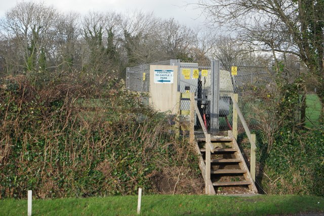
///spiking.division.banquets. Near Wool, Dorset
Nearby Locations
Related Wikis

East Lulworth
East Lulworth is a village and civil parish nine miles east of Dorchester, near Lulworth Cove, in the county of Dorset, South West England. It consists...

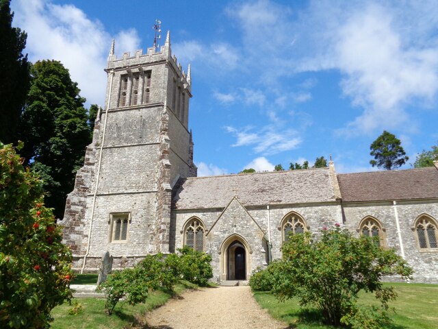
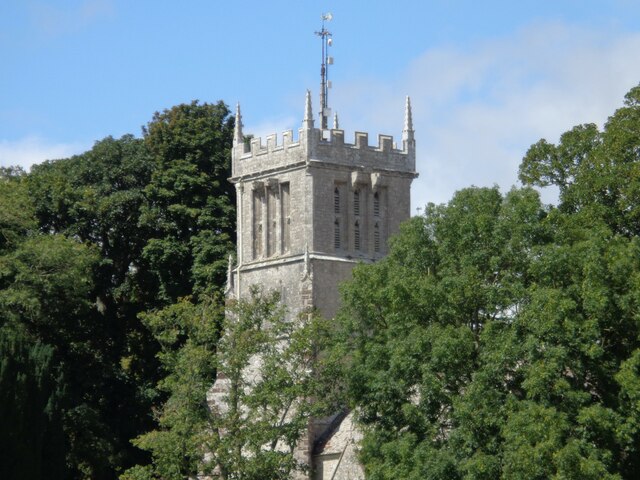
Holy Rood Church, Coombe Keynes
Holy Rood Church is a former Church of England church in Coombe Keynes, Dorset, England. Most of the church dates to a rebuild of 1860–61, but the tower...
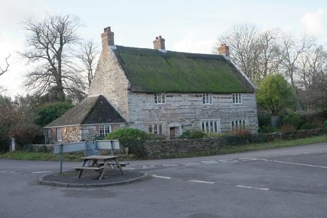
Coombe Keynes
Coombe Keynes is a hamlet, civil parish and depopulated village in the Purbeck district of Dorset, England. The village is about 2 miles (3 km) south of...

Bestival
Bestival was a four-day music festival held in the south of England. The name Bestival is a portmanteau of the words best and festival. It had been held...

Lulworth Estate
The Lulworth Estate is a country estate located in central south Dorset, England. Its most notable landscape feature is a five-mile stretch of coastline...
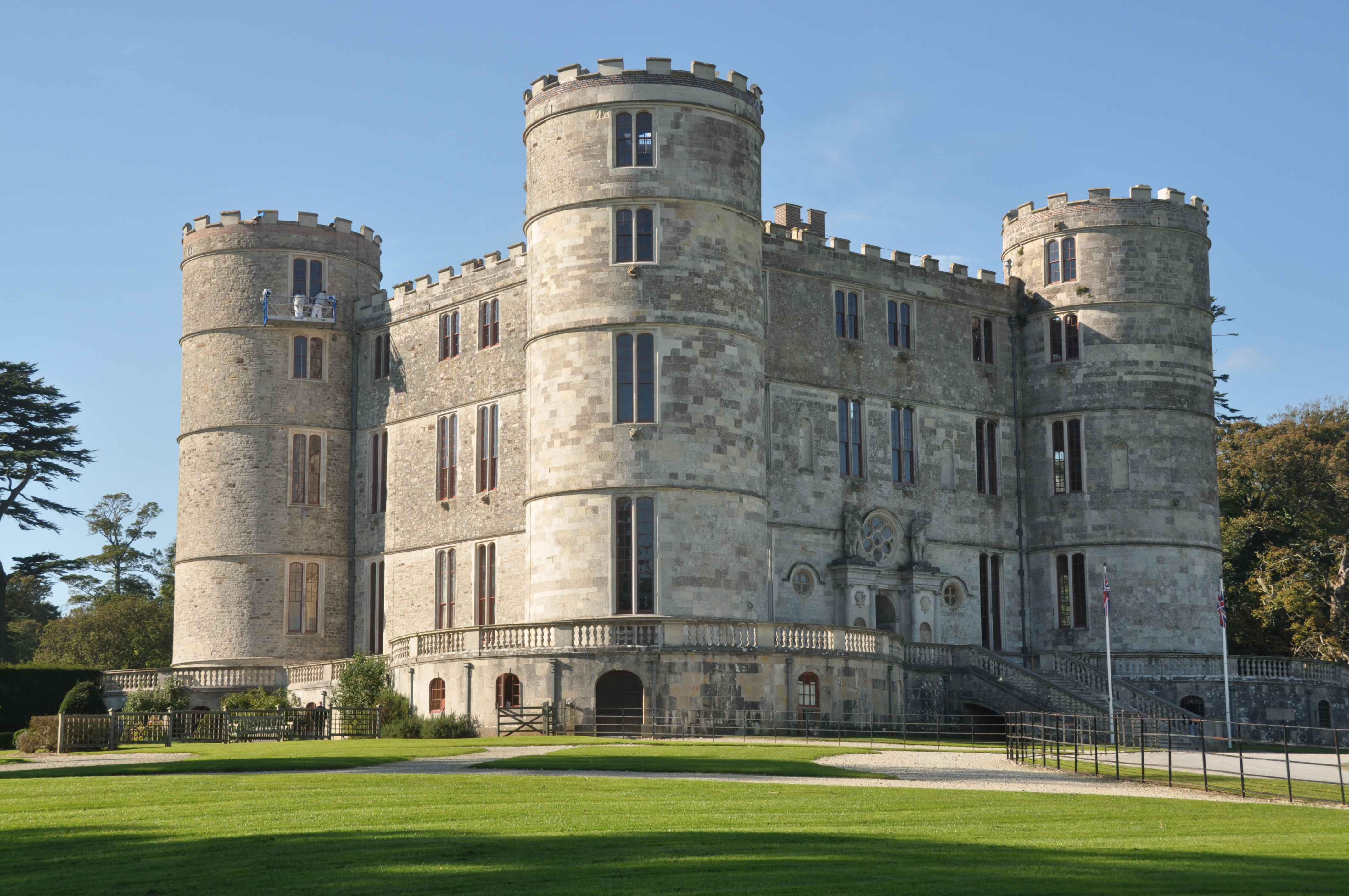
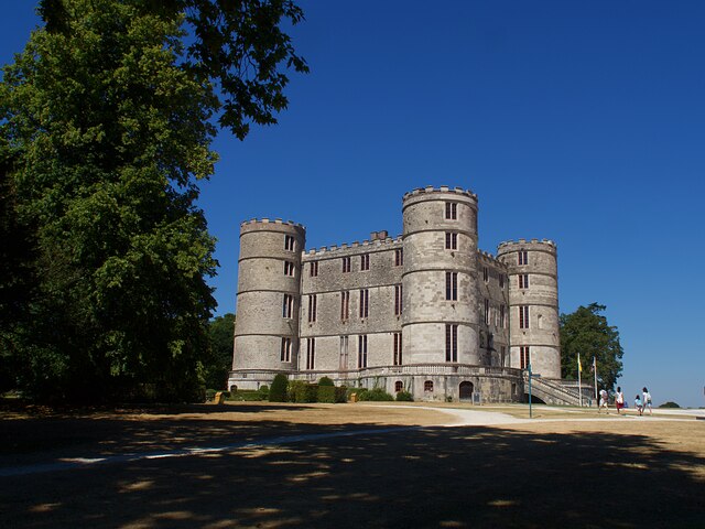
Lulworth Castle
Lulworth Castle, in East Lulworth, Dorset, England, situated south of the village of Wool, is an early 17th-century hunting lodge erected in the style...

Lulworth Ranges
The Lulworth Ranges are military firing ranges located between Wareham and Lulworth in Dorset, England. They cover an area of more than 2,830 hectares...
Lulworth Abbey
Lulworth Abbey was a Trappist monastery at East Lulworth in Dorset, England, established as a priory in 1796 by Thomas Weld for refugee French Trappist...
Nearby Amenities
Located within 500m of 50.654179,-2.1976362Have you been to The Lake?
Leave your review of The Lake below (or comments, questions and feedback).