Stocks Reservoir

Lake, Pool, Pond, Freshwater Marsh in Yorkshire Ribble Valley

England

Stocks Reservoir

View of Forest of Bowland from near Stocks Reservoir The view shows the River Hodder just after it flows into the Stocks reservoir. It flows south to join the River Ribble. The hills in the distance are part of the Forest of Bowland
View of Forest of Bowland from near Stocks Reservoir Credit: Rod Grealish

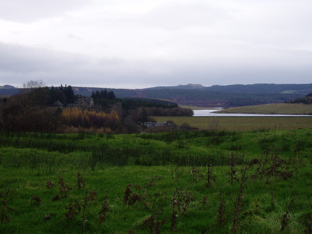
Stocks Reservoir is a large man-made freshwater lake located in the county of Yorkshire, England. It covers an area of approximately 350 acres and is situated in the beautiful Forest of Bowland, a designated Area of Outstanding Natural Beauty. The reservoir was constructed in the early 1930s to supply drinking water to the nearby towns and villages.

Surrounded by rolling hills and verdant woodlands, Stocks Reservoir offers a tranquil and picturesque setting. Its calm and clear waters are home to a diverse range of flora and fauna, making it a haven for nature enthusiasts and bird watchers. The reservoir is particularly renowned for its population of wildfowl, including tufted ducks, teal, and wigeons.

Fishing is a popular activity at Stocks Reservoir, with anglers flocking to the lake to try their luck at catching trout. The reservoir is well-stocked with both brown and rainbow trout, providing an excellent opportunity for both experienced and novice fishermen. Permits are required for fishing and can be obtained from the on-site fishing lodge.

The reservoir is also a popular destination for leisurely walks and picnics. A scenic path around the lake offers stunning views of the surrounding countryside, while designated picnic spots provide the perfect opportunity for visitors to relax and take in the peaceful atmosphere.

Overall, Stocks Reservoir is a stunning freshwater lake set in a picturesque location. With its diverse wildlife, excellent fishing opportunities, and beautiful surroundings, it is a must-visit destination for nature lovers and outdoor enthusiasts in Yorkshire.

If you have any feedback on the listing, please let us know in the comments section below.

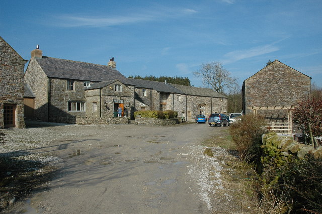
Stocks Reservoir Images

Images are sourced within 2km of 53.994075/-2.4172878 or Grid Reference SD7255. Thanks to Geograph Open Source API. All images are credited.

View of Forest of Bowland from near Stocks Reservoir The view shows the River Hodder just after it flows into the Stocks reservoir. It flows south to join the River Ribble. The hills in the distance are part of the Forest of Bowland
View of Forest of Bowland from near Stocks Reservoir
The view shows the River Hodder just after it flows into the Stocks reservoir. It flows south to join the River Ribble. The hills in the distance are part of the Forest of Bowland
River Hodder entering Stocks Reservoir The photo shows the point at which the River Hodder enters the Stocks Reservoir. The reservoir is at a particularly low level. It was opened in 1932 and supplies Blackpool and the Fylde coast. There are a number of waymarked forest walks and cycle routes. Trout fishing is available.
River Hodder entering Stocks Reservoir
The photo shows the point at which the River Hodder enters the Stocks Reservoir. The reservoir is at a particularly low level. It was opened in 1932 and supplies Blackpool and the Fylde coast. There are a number of waymarked forest walks and cycle routes. Trout fishing is available.
The entrance to Gisburn Forest Hub From Hole House Lane, which used to be a very quiet road, the entrance to Gisburn Forest Hub and the Stephen Park Centre now attracts a lot more traffic than when I last passed this way (probably over thirty years ago). The track leads to probably the biggest car park in the forest, and the sign suggest that it is not a free one (I didn't park here, so cannot vouch for this). Beyond the car park, the network of tracks become essentially traffic-free and is popular with moountain bikers.
The entrance to Gisburn Forest Hub
From Hole House Lane, which used to be a very quiet road, the entrance to Gisburn Forest Hub and the Stephen Park Centre now attracts a lot more traffic than when I last passed this way (probably over thirty years ago). The track leads to probably the biggest car park in the forest, and the sign suggest that it is not a free one (I didn't park here, so cannot vouch for this). Beyond the car park, the network of tracks become essentially traffic-free and is popular with moountain bikers.
Track to Brookhouse Green A brief break from mountain biking to nip down the track to Brookhouse Green and the square just beyond it on foot, as this is a public footpath, not a bridleway. A shower had just scudded past - enough to quickly don a waterproof, but not really enough to actually get wet, so it was back off in time for the rainbow which ensued a few minutes later.
Track to Brookhouse Green
A brief break from mountain biking to nip down the track to Brookhouse Green and the square just beyond it on foot, as this is a public footpath, not a bridleway. A shower had just scudded past - enough to quickly don a waterproof, but not really enough to actually get wet, so it was back off in time for the rainbow which ensued a few minutes later.
Track between Rain Gill and Brookhouse Green A brief sunny interlude after a short light shower gives nice light and shade on this farm track, looking towards Brookhouse Green and the way back to the minor road from Clapham to Slaidburn.
Track between Rain Gill and Brookhouse Green
A brief sunny interlude after a short light shower gives nice light and shade on this farm track, looking towards Brookhouse Green and the way back to the minor road from Clapham to Slaidburn.
St. James' Church, Dalehead A sign by the path in, on the left (west) says "Dalehead Church and Heritage Centre". Heritage possibly doesn't need a lot of energy - the centre has a wind turbine, but it seems to be well below tree-top height, which must limit its ability to kick out power. On the bright side, not many people seem to die here - it's an extensive graveyard with very few headstones.
St. James' Church, Dalehead
A sign by the path in, on the left (west) says "Dalehead Church and Heritage Centre". Heritage possibly doesn't need a lot of energy - the centre has a wind turbine, but it seems to be well below tree-top height, which must limit its ability to kick out power. On the bright side, not many people seem to die here - it's an extensive graveyard with very few headstones.
Tiny stream in Gisburn Forest A public footpath leaves School Lane to head northwest into the forest, but is scarcely visible on the ground. Crossing this stream, it climbs the muddy bank above to meet a recently made decent path, where the public right of way follows it for a short while towards Stocks reservoir before resuming its course into the forest and becoming totally vague once more. The new path also continues northeast, not a right of way but clearly much more frequented than the public footpath itself. Downhill, the new path passes into the open near the shore of the reservoir, and quite close to the car park at the corner of School Lane.
Tiny stream in Gisburn Forest
A public footpath leaves School Lane to head northwest into the forest, but is scarcely visible on the ground. Crossing this stream, it climbs the muddy bank above to meet a recently made decent path, where the public right of way follows it for a short while towards Stocks reservoir before resuming its course into the forest and becoming totally vague once more. The new path also continues northeast, not a right of way but clearly much more frequented than the public footpath itself. Downhill, the new path passes into the open near the shore of the reservoir, and quite close to the car park at the corner of School Lane.
Bird hide above the shore of Stocks Reservoir Tucked away on the edge of the forest, overlooking the shore of Stocks Reservoir, United Utilities have provided this and at least one other wildlife hide. It really is quite well concealed, whilst offering a clear view over many geese at the upstream end of the water (at least today). A barbed wire fence effectively deters one from getting any closer to the water, or, indeed, getting a clearer picture of the hide itself.
Bird hide above the shore of Stocks Reservoir
Tucked away on the edge of the forest, overlooking the shore of Stocks Reservoir, United Utilities have provided this and at least one other wildlife hide. It really is quite well concealed, whilst offering a clear view over many geese at the upstream end of the water (at least today). A barbed wire fence effectively deters one from getting any closer to the water, or, indeed, getting a clearer picture of the hide itself.
No School - School Lane No sign of a school in sight!  This just seems to be a pleasant forest drive!
No School - School Lane
No sign of a school in sight! This just seems to be a pleasant forest drive!
Micro Forest Moss atop a stone wall reminded me of a miniature forest!
Micro Forest
Moss atop a stone wall reminded me of a miniature forest!
Down School Lane Looking down School Lane towards the Stocks Reservoir.
Down School Lane
Looking down School Lane towards the Stocks Reservoir.
Path in the Forest of Bowland
Mossy Logs in the Forest of Bowland
Stocks Reservoir from near the Bird Hide
Stephen Park Stephen Park is a group of small cottages inside Gisburn Forest.
Stephen Park
Stephen Park is a group of small cottages inside Gisburn Forest.
Gisburn Forest This is one of the cycle trails through Gisburn Forest.
Gisburn Forest
This is one of the cycle trails through Gisburn Forest.
Stocks Reservoir From the road out of Slaidburn
Stocks Reservoir
From the road out of Slaidburn
Looking out over Stocks Reservoir, Forest of Bowland Lovely view, great place to go Mountain Biking or Horse Riding on purpose-built trails
Looking out over Stocks Reservoir, Forest of Bowland
Lovely view, great place to go Mountain Biking or Horse Riding on purpose-built trails
Show me another place!

Stocks Reservoir is located at Grid Ref: SD7255 (Lat: 53.994075, Lng: -2.4172878)

Division: West Riding

Administrative County: Lancashire

District: Ribble Valley

Police Authority: Lancashire

What 3 Words

///mice.newsprint.focus. Near Waddington, Lancashire

Nearby Locations

Stocks Reservoir

Related Wikis

Stocks Reservoir

Stocks Reservoir is a reservoir situated at the head of the Hodder valley in the Forest of Bowland, Lancashire, England (historically in the West Riding...

Easington, Lancashire

Easington () is a civil parish within the Ribble Valley district of Lancashire, England, with a population in 2001 of 52. The Census 2011 population details...

Lancashire Witches Walk

The Lancashire Witches Walk is a 51-mile (82 km) long-distance footpath opened in 2012, between Barrowford and Lancaster, all in Lancashire, England. It...

Slaidburn

Slaidburn () is a village and civil parish within the Ribble Valley district of Lancashire, England. The parish covers just over 5,000 acres of the Forest...

Nearby Amenities

Located within 500m of 53.994075,-2.4172878
Barrier: cattle_grid
Source: Bing
Lat/Long: 53.9909119/-2.4132935
The data included in this document is from www.openstreetmap.org. The data is made available under ODbL.

Have you been to Stocks Reservoir?

Leave your review of Stocks Reservoir below (or comments, questions and feedback).