Middle Pool

Lake, Pool, Pond, Freshwater Marsh in Shropshire

England

Middle Pool
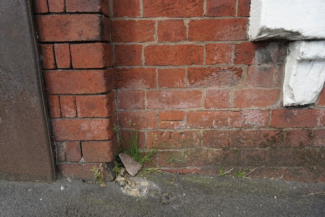
New Yard, St Georges The OS benchmark cut into the former New Yard Engineering Works in St. Georges, Telford. It was levelled in 1961 and last verified by the OS in 1985. It is recorded as being 141.37-metres above the Ordnance Datum at Newlyn
New Yard, St Georges Credit: Anthony Rowley

Middle Pool is a picturesque freshwater marsh located in Shropshire, England. Spanning over an area of approximately 10 acres, this tranquil water body is nestled amidst the stunning countryside of the region. It is situated near the village of Middle and is easily accessible for nature enthusiasts and visitors alike.

The pool features crystal-clear water, which is sourced from natural springs and rainfall. Surrounded by lush green vegetation and tall reeds, Middle Pool offers a diverse habitat for a variety of aquatic plants and wildlife. The marshy areas around the pool are home to a plethora of wetland species, including waterfowl, amphibians, and insects, making it a haven for birdwatchers and nature photographers.

The pool itself is a popular destination for fishing enthusiasts, with its calm and serene atmosphere providing the perfect setting for a day of angling. It is stocked with a variety of fish species, such as carp, tench, bream, and roach, ensuring a rewarding experience for both amateur and experienced anglers. Fishing platforms and pegs are strategically placed around the pool, allowing easy access and convenience for visitors.

Middle Pool also offers a peaceful and idyllic setting for those seeking relaxation and tranquility. The surrounding walking trails provide an opportunity for leisurely strolls, allowing visitors to immerse themselves in the natural beauty of the area. The pool's serene ambiance, combined with the gentle sounds of nature, makes it an ideal spot for picnics, meditation, or simply unwinding in the midst of nature.

Overall, Middle Pool in Shropshire is a scenic and biodiverse freshwater marsh that offers a range of activities for nature lovers and visitors seeking a peaceful retreat. Its natural beauty, abundant wildlife, and tranquil atmosphere make it a must-visit destination for anyone exploring the region.

If you have any feedback on the listing, please let us know in the comments section below.

Middle Pool Images

Images are sourced within 2km of 52.703761/-2.4620074 or Grid Reference SJ6811. Thanks to Geograph Open Source API. All images are credited.

New Yard, St Georges The OS benchmark cut into the former New Yard Engineering Works in St. Georges, Telford. It was levelled in 1961 and last verified by the OS in 1985. It is recorded as being 141.37-metres above the Ordnance Datum at Newlyn
New Yard, St Georges
The OS benchmark cut into the former New Yard Engineering Works in St. Georges, Telford. It was levelled in 1961 and last verified by the OS in 1985. It is recorded as being 141.37-metres above the Ordnance Datum at Newlyn
Marrion's Hill approaching West Street Viewed from the junction with Hill Crest Road.
Marrion's Hill approaching West Street
Viewed from the junction with Hill Crest Road.
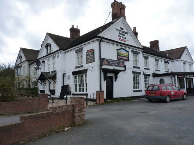
The White Horse
The White Horse
OS benchmark - Oakengates, Station Hill An OS cutmark in a stone wall on the N side of the steep Station Hill; originally levelled in 1960 at 147.25m above Ordnance Datum Newlyn.
OS benchmark - Oakengates, Station Hill
An OS cutmark in a stone wall on the N side of the steep Station Hill; originally levelled in 1960 at 147.25m above Ordnance Datum Newlyn.
OS benchmark - Oakengates, 68 The Nabb An OS cutmark on the brickwork of no68 The Nabb (Diamond Row); originally levelled in 1961 at 145.62m above Ordnance Datum Newlyn.
OS benchmark - Oakengates, 68 The Nabb
An OS cutmark on the brickwork of no68 The Nabb (Diamond Row); originally levelled in 1961 at 145.62m above Ordnance Datum Newlyn.
OS benchmark - Wrockwardine Wood, New Road An OS cutmark on a wall on the west side of New Road; originally levelled at 112.28m above Ordnance Datum Newlyn.
OS benchmark - Wrockwardine Wood, New Road
An OS cutmark on a wall on the west side of New Road; originally levelled at 112.28m above Ordnance Datum Newlyn.
OS benchmark -Wrockwardine Wood, Furnace Lane An OS cutmark on a house called Fairview; originally levelled at 104.16m above Ordnance Datum Newlyn.
OS benchmark -Wrockwardine Wood, Furnace Lane
An OS cutmark on a house called Fairview; originally levelled at 104.16m above Ordnance Datum Newlyn.
Spice of India restaurant, Gower Street This building was formerly a pub named The Barley Mow - see (2011 picture) <a href="https://www.geograph.org.uk/photo/2233221">SJ7010 : The Barley Mow, St George's</a> and (boarded up and for sale in 2008) <a href="https://www.geograph.org.uk/photo/858300">SJ7010 : The Barley Mow, St George's</a>.  This is one of numerous pubs in the St George's district of Telford. Becoming a restaurant has at least saved the building from demolition.
Spice of India restaurant, Gower Street
This building was formerly a pub named The Barley Mow - see (2011 picture) SJ7010 : The Barley Mow, St George's and (boarded up and for sale in 2008) SJ7010 : The Barley Mow, St George's. This is one of numerous pubs in the St George's district of Telford. Becoming a restaurant has at least saved the building from demolition.
Former Gower Street Youth Centre Known locally as 'The Gower', and currently empty and undergoing restoration, the building dates from the 1870s. It has been both hospital and school in its time, but most recently was used as a Youth Centre. Plans had been drawn up to demolish the building and replace it with housing and a supermarket, but a local petition signed by nearly 1000 people led to the building being saved, to be restored for community use. The Gower is now grade 2 listed.
Other views: <a href="https://www.geograph.org.uk/photo/4762097">SJ7011 : The Gower, under restoration</a>, <a href="https://www.geograph.org.uk/photo/4762108">SJ7011 : The Gower, St George's</a>.
Former Gower Street Youth Centre
Known locally as 'The Gower', and currently empty and undergoing restoration, the building dates from the 1870s. It has been both hospital and school in its time, but most recently was used as a Youth Centre. Plans had been drawn up to demolish the building and replace it with housing and a supermarket, but a local petition signed by nearly 1000 people led to the building being saved, to be restored for community use. The Gower is now grade 2 listed. Other views: SJ7011 : The Gower, under restoration, SJ7011 : The Gower, St George's.
The Gower, under restoration Somewhat hidden by fence and scaffolding, this is the centre part of this grade 2 listed building known locally as The Gower. The building was built in 1873 as a hospital for workers from Lilleshall Mining Company. 
Wider views: <a href="https://www.geograph.org.uk/photo/4762080">SJ7011 : Former Gower Street Youth Centre</a>, <a href="https://www.geograph.org.uk/photo/4762108">SJ7011 : The Gower, St George's</a>.
The Gower, under restoration
Somewhat hidden by fence and scaffolding, this is the centre part of this grade 2 listed building known locally as The Gower. The building was built in 1873 as a hospital for workers from Lilleshall Mining Company. Wider views: SJ7011 : Former Gower Street Youth Centre, SJ7011 : The Gower, St George's.
The Gower, St George's Built in 1873 as a hospital for workers from Lilleshall Mining Company, the building now known locally as 'The Gower' has also served as a school and most recently as a Youth Centre. The building then fell derelict, and plans were in place for its demolition when local pressure and the granting of Grade 2 listed building status persuaded the Council to agree to the renovation of the building. Some lottery funding has been secured to support the project which will eventually see The Gower restored for community use.
Other views: <a href="https://www.geograph.org.uk/photo/4762080">SJ7011 : Former Gower Street Youth Centre</a>, <a href="https://www.geograph.org.uk/photo/4762097">SJ7011 : The Gower, under restoration</a>.
The Gower, St George's
Built in 1873 as a hospital for workers from Lilleshall Mining Company, the building now known locally as 'The Gower' has also served as a school and most recently as a Youth Centre. The building then fell derelict, and plans were in place for its demolition when local pressure and the granting of Grade 2 listed building status persuaded the Council to agree to the renovation of the building. Some lottery funding has been secured to support the project which will eventually see The Gower restored for community use. Other views: SJ7011 : Former Gower Street Youth Centre, SJ7011 : The Gower, under restoration.
White Horse Tavern   Wrockwardine Wood Telford White Horse Tavern
New Rd, Wrockwardine Wood Telford TF2 7AB
Taken September 2016
White Horse Tavern Wrockwardine Wood Telford
White Horse Tavern New Rd, Wrockwardine Wood Telford TF2 7AB Taken September 2016
White Horse Tavern Wrockwardine Wood Telford White Horse Tavern Wrockwardine Wood Telford TF27AB
Taken on a sunday morning in September 2016
White Horse Tavern Wrockwardine Wood Telford
White Horse Tavern Wrockwardine Wood Telford TF27AB Taken on a sunday morning in September 2016
White Horse Tavern looking from rear of pub White Horse Tavern 
New Rd, Wrockwardine Wood Telford TF2 7AB
looking from rear of pub showing Bowling club
White Horse Tavern looking from rear of pub
White Horse Tavern New Rd, Wrockwardine Wood Telford TF2 7AB looking from rear of pub showing Bowling club
The Gower building - rear view The rear side of what was originally built in 1873 as The Granville Hospital, a cottage hospital for the workers of the nearby Lilleshall Company at Snedshill (signs of that business are long gone), and changed to use as a school in 1879. School use persisted right through until the late 1950s, and then in the mid 1960s it became a youth and community centre, until eventual closure in 2006.  It was given a Grade II listing in 2014 <span class="nowrap"><a title="https://www.britishlistedbuildings.co.uk/101418616-gower-street-school-former-cottage-hospital-telford-st-georges-and-priorslee#.WRFd3fkrKM8" rel="nofollow ugc noopener" href="https://www.britishlistedbuildings.co.uk/101418616-gower-street-school-former-cottage-hospital-telford-st-georges-and-priorslee#.WRFd3fkrKM8">Link</a><img style="margin-left:2px;" alt="External link" title="External link - shift click to open in new window" src="https://s1.geograph.org.uk/img/external.png" width="10" height="10"/></span> after threats of demolition were made, for the site to be used for yet more housing and a supermarket. It is considered a rare example of a largely intact 19th century cottage hospital, and many of the original interior features and rooms survive, albeit converted during its time as a school.
The Gower building - rear view
The rear side of what was originally built in 1873 as The Granville Hospital, a cottage hospital for the workers of the nearby Lilleshall Company at Snedshill (signs of that business are long gone), and changed to use as a school in 1879. School use persisted right through until the late 1950s, and then in the mid 1960s it became a youth and community centre, until eventual closure in 2006. It was given a Grade II listing in 2014 LinkExternal link after threats of demolition were made, for the site to be used for yet more housing and a supermarket. It is considered a rare example of a largely intact 19th century cottage hospital, and many of the original interior features and rooms survive, albeit converted during its time as a school.
The Gower building - frontage The front view of what was originally built in 1873 as The Granville Hospital, a cottage hospital for the workers of the nearby Lilleshall Company at Snedshill (signs of that business are long gone), and changed to use as a school in 1879. School use persisted right through until the late 1950s, and then in the mid 1960s it became a youth and community centre, until eventual closure in 2006. It was given a Grade II listing in 2014 <span class="nowrap"><a title="https://www.britishlistedbuildings.co.uk/101418616-gower-street-school-former-cottage-hospital-telford-st-georges-and-priorslee" rel="nofollow ugc noopener" href="https://www.britishlistedbuildings.co.uk/101418616-gower-street-school-former-cottage-hospital-telford-st-georges-and-priorslee">Link</a><img style="margin-left:2px;" alt="External link" title="External link - shift click to open in new window" src="https://s1.geograph.org.uk/img/external.png" width="10" height="10"/></span> after threats of demolition were made, for the site to be used for yet more housing and a supermarket. It is considered a rare example of a largely intact 19th century cottage hospital, and many of the original interior features and rooms survive, albeit converted during its time as a school.
Update November 2019. Local press reports suggest that the building could be brought back into full community use (not sure quite what that means) including a bar and outdoor space, provided the scheme is backed by the public. Two local councils have offered funds of roughly £1.2m to pay for the work, subject to community consultation.
The Gower building - frontage
The front view of what was originally built in 1873 as The Granville Hospital, a cottage hospital for the workers of the nearby Lilleshall Company at Snedshill (signs of that business are long gone), and changed to use as a school in 1879. School use persisted right through until the late 1950s, and then in the mid 1960s it became a youth and community centre, until eventual closure in 2006. It was given a Grade II listing in 2014 LinkExternal link after threats of demolition were made, for the site to be used for yet more housing and a supermarket. It is considered a rare example of a largely intact 19th century cottage hospital, and many of the original interior features and rooms survive, albeit converted during its time as a school. Update November 2019. Local press reports suggest that the building could be brought back into full community use (not sure quite what that means) including a bar and outdoor space, provided the scheme is backed by the public. Two local councils have offered funds of roughly £1.2m to pay for the work, subject to community consultation.
The Rectory, Wrockwardine Wood Built in the early 19th century, around the same time as the nearby <a href="https://www.geograph.org.uk/photo/1156329">SJ6912 : Holy Trinity Church, Wrockwardine Wood, Telford</a>, and Grade II listed <span class="nowrap"><a title="https://britishlistedbuildings.co.uk/101025281-rectory-holy-trinity-wrockwardine-wood-and-trench#.XBvJINSLTGg" rel="nofollow ugc noopener" href="https://britishlistedbuildings.co.uk/101025281-rectory-holy-trinity-wrockwardine-wood-and-trench#.XBvJINSLTGg">Link</a><img style="margin-left:2px;" alt="External link" title="External link - shift click to open in new window" src="https://s1.geograph.org.uk/img/external.png" width="10" height="10"/></span> in 1983.
The Rectory, Wrockwardine Wood
Built in the early 19th century, around the same time as the nearby SJ6912 : Holy Trinity Church, Wrockwardine Wood, Telford, and Grade II listed LinkExternal link in 1983.
The Bull's Head Inn, Wrockwardine Wood Built in the late 19th century, and fronted extensively with tiles from the Maws Tileworks at Coalport, The Bull's Head was renovated in 1984, very shortly after being Grade II listed <span class="nowrap"><a title="https://britishlistedbuildings.co.uk/101033298-bulls-head-public-house-wrockwardine-wood-and-trench#.XBvLDdSLTGg" rel="nofollow ugc noopener" href="https://britishlistedbuildings.co.uk/101033298-bulls-head-public-house-wrockwardine-wood-and-trench#.XBvLDdSLTGg">Link</a><img style="margin-left:2px;" alt="External link" title="External link - shift click to open in new window" src="https://s1.geograph.org.uk/img/external.png" width="10" height="10"/></span> the year before. The interior is also much tiled.
The Bull's Head Inn, Wrockwardine Wood
Built in the late 19th century, and fronted extensively with tiles from the Maws Tileworks at Coalport, The Bull's Head was renovated in 1984, very shortly after being Grade II listed LinkExternal link the year before. The interior is also much tiled.
Show me another place!

Middle Pool is located at Grid Ref: SJ6811 (Lat: 52.703761, Lng: -2.4620074)

Unitary Authority: Telford and Wrekin

Police Authority: West Mercia

What 3 Words

///ramp.walking.thudding. Near Oakengates, Shropshire

Nearby Locations

Middle Pool

Related Wikis

Wombridge Priory

Wombridge Priory was a small Augustinian monastery in Shropshire. Established in the early 12th century, it was supported by a network of minor nobility...

Telford Priory School

Telford Priory School is a coeducational secondary school located in the Wrockwardine Wood area of Telford in Shropshire, England. The school opened in...

Trench, Telford

Trench is a suburb of Telford in the borough of Telford and Wrekin and ceremonial county of Shropshire, England. It is to the north of the town and north...

New Hadley Halt railway station

New Hadley Halt was a minor station between Oakengates and Wellington on the former Great Western Railway's London Paddington to Birkenhead via Birmingham...

Nearby Amenities

Located within 500m of 52.703761,-2.4620074
Motorway Junction
Wombridge Interchange
Lat/Long: 52.7067388/-2.4619935
Motorway Junction
Wombridge Interchange
Lat/Long: 52.702312/-2.4563374
Created By: Merkaartor 0.12
Lat/Long: 52.7025769/-2.461248
Created By: Merkaartor 0.12
Lat/Long: 52.705073/-2.4559378
Barrier: cycle_barrier
Bicycle: yes
Foot: yes
Lat/Long: 52.7031525/-2.4570672
Pub
Blue Pig
Addr City: Telford
Addr Postcode: TF2 6QQ
Addr Street: Capewell Road
Addr Suburb: Donnington
Brand: Marston's
Brand Wikidata: Q6773982
Contact Facebook: https://www.facebook.com/pages/Blue%20Pig/528305713957312/
Fhrs Id: 1250595
Source Addr: FHRS Open Data
Lat/Long: 52.7076652/-2.4637433
Noexit: yes
Lat/Long: 52.7058048/-2.4665953
Give Way
Direction: backward
Source: bing
Lat/Long: 52.7005598/-2.4637967
Trench Lock
Place: suburb
Lat/Long: 52.7064593/-2.4674253
BMX track
Leisure: park
Lat/Long: 52.7017145/-2.4612535
Leisure: pitch
Sport: skateboard
Lat/Long: 52.7014143/-2.4606448
Noexit: yes
Lat/Long: 52.7071882/-2.4667806
Noexit: yes
Lat/Long: 52.7073979/-2.4656138
Noexit: yes
Lat/Long: 52.7072906/-2.4649111
Noexit: yes
Lat/Long: 52.705599/-2.4659468
Generator Method: photovoltaic
Generator Output Biogas: yes
Generator Source: solar
Generator Type: solar_photovoltaic_panel
Location: roof
Power: generator
Lat/Long: 52.7069127/-2.4586844
Generator Method: photovoltaic
Generator Output Biogas: yes
Generator Source: solar
Generator Type: solar_photovoltaic_panel
Location: roof
Power: generator
Lat/Long: 52.7074222/-2.4605566
Crossing
Lat/Long: 52.7049247/-2.4551903
Generator Method: photovoltaic
Generator Output Electricity: yes
Generator Source: solar
Generator Type: solar_photovoltaic_panel
Location: roof
Power: generator
Lat/Long: 52.7006441/-2.4588776
Generator Method: photovoltaic
Generator Output Electricity: yes
Generator Source: solar
Generator Type: solar_photovoltaic_panel
Location: roof
Power: generator
Lat/Long: 52.7009611/-2.4586228
Generator Method: photovoltaic
Generator Output Electricity: yes
Generator Source: solar
Generator Type: solar_photovoltaic_panel
Location: roof
Power: generator
Lat/Long: 52.7009838/-2.4585289
Noexit: yes
Lat/Long: 52.7059417/-2.4668438
Noexit: yes
Lat/Long: 52.7063645/-2.4677387
Barrier: cycle_barrier
Cycle Barrier: tilted
Lat/Long: 52.7024213/-2.4569716
Crossing
Crossing: unmarked
Crossing Markings: no
Lat/Long: 52.7054903/-2.4658199
Crossing
Crossing: unmarked
Crossing Island: no
Crossing Markings: no
Tactile Paving: yes
Lat/Long: 52.7061255/-2.4678781
Barrier: kerb
Kerb: flush
Lat/Long: 52.705956/-2.4673188
Barrier: kerb
Kerb: flush
Lat/Long: 52.7060191/-2.4672463
Crossing
Button Operated: yes
Crossing: traffic_signals
Crossing Island: no
Crossing Markings: dots
Tactile Paving: yes
Lat/Long: 52.7059851/-2.4672854
Barrier: kerb
Kerb: flush
Tactile Paving: yes
Lat/Long: 52.7061508/-2.4679267
Barrier: kerb
Kerb: flush
Tactile Paving: yes
Lat/Long: 52.70611/-2.4678422
The data included in this document is from www.openstreetmap.org. The data is made available under ODbL.

Have you been to Middle Pool?

Leave your review of Middle Pool below (or comments, questions and feedback).