Herbuck

Lake, Pool, Pond, Freshwater Marsh in Yorkshire South Lakeland

England

Herbuck

OS Bench Mark OS cut bench mark from the 19th century levelling, on the corner of Rose Cottage. 469.3 feet above old datum. Badly eroded and almost illegible.
OS Bench Mark Credit: Phil Johnstone

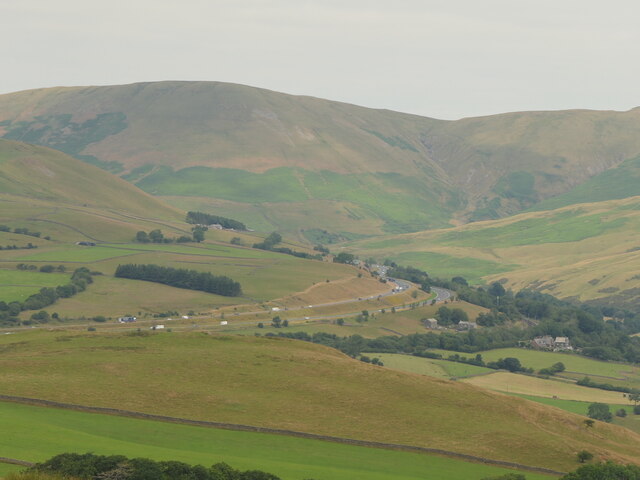
Herbuck, Yorkshire is a picturesque region located in the heart of England, renowned for its stunning natural landscapes and abundant freshwater ecosystems. The area encompasses a diverse range of water bodies, including lakes, pools, ponds, and freshwater marshes, which contribute to its unique ecological beauty.

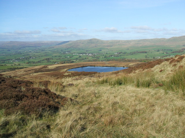
The centerpiece of Herbuck is its expansive lake, which stretches across several acres and provides a serene haven for both wildlife and visitors alike. The crystal-clear waters of the lake are home to a plethora of freshwater fish species, such as trout, perch, and pike, making it a popular destination for fishing enthusiasts.

Surrounding the lake are numerous pools and ponds, acting as smaller satellite ecosystems that further enhance the region's biodiversity. These bodies of water provide vital habitats for various aquatic plants, insects, and amphibians, fostering a delicate balance of species within the area.

One of the most captivating features of Herbuck is its freshwater marshes. These wetland areas are characterized by their lush vegetation, including reeds, rushes, and water lilies. The marshes act as a natural filtering system, purifying the water and providing a safe haven for a wide range of bird species, including herons, ducks, and kingfishers.

The diverse array of water bodies in Herbuck, Yorkshire, serves not only as a haven for wildlife but also as a recreational paradise for visitors. The region offers opportunities for boating, kayaking, and wildlife spotting, attracting nature enthusiasts from far and wide.

In conclusion, Herbuck, Yorkshire, is a captivating region renowned for its breathtaking lakes, pools, ponds, and freshwater marshes. Its diverse aquatic ecosystems support a rich array of wildlife and provide a serene escape for visitors seeking to immerse themselves in the beauty of nature.

If you have any feedback on the listing, please let us know in the comments section below.

Herbuck Images

Images are sourced within 2km of 54.352715/-2.5776807 or Grid Reference SD6295. Thanks to Geograph Open Source API. All images are credited.

OS Bench Mark OS cut bench mark from the 19th century levelling, on the corner of Rose Cottage. 469.3 feet above old datum. Badly eroded and almost illegible.
OS Bench Mark
OS cut bench mark from the 19th century levelling, on the corner of Rose Cottage. 469.3 feet above old datum. Badly eroded and almost illegible.
Stile, Firbank Fell A gap stile where a path leaves the road.
Stile, Firbank Fell
A gap stile where a path leaves the road.
Firbank Fell Used by the Westmorland Motor Club, but quiet today.
Firbank Fell
Used by the Westmorland Motor Club, but quiet today.
Firbank Fell summit
Firbank Fell summit
M6, Lunedale
M6, Lunedale
Crooked tree behind Fox's Pulpit A very attractive bit of moorland with complex contours.
Crooked tree behind Fox's Pulpit
A very attractive bit of moorland with complex contours.
Summit, Knotts A view of the Howgill Fells.
Summit, Knotts
A view of the Howgill Fells.
Castley A farm at the foot of Fell Head.
Castley
A farm at the foot of Fell Head.
Tarnhouse Barn
Tarnhouse Barn
Fields around the Chapel Beck The chapel which gives its name to the beck is on the right.
Fields around the Chapel Beck
The chapel which gives its name to the beck is on the right.
Knotts The summit area.
Knotts
The summit area.
Lowgill Viaduct On the Ingleton Branch between Tebay and Clapham. The line closed gradually with various services being withdrawn over the 1950s and 1960s with the tracks finally lifted in 1967.
Lowgill Viaduct
On the Ingleton Branch between Tebay and Clapham. The line closed gradually with various services being withdrawn over the 1950s and 1960s with the tracks finally lifted in 1967.
B6257 Passing Lowgill Viaduct.
B6257
Passing Lowgill Viaduct.
 M6 northbound
M6 northbound
Road over Firbank Fell Taken during a scenic detour due to the M6 being closed. It was raining hard. View towards Fox's Pulpit.
Road over Firbank Fell
Taken during a scenic detour due to the M6 being closed. It was raining hard. View towards Fox's Pulpit.
Lowgill Viaduct Lowgill Viaduct, Ingleton branch. The Ingleton branch left the Skipton - Lancaster line at Clapham Junction and ran through Ingleton, Kirkby Lonsdale & Sedburgh, joining what is now the WCML at Lowgill, south of Tebay. Had the Midland and the LNWR reached agreement before parliament forced the Midland to build the S&C, this would have been the Midland’s main line to Scotland. As it was, the Midland was ordered to follow through with its plans for the S&C, and the Ingleton branch operated for around a century as a country backwater and sometime diversionary route. Opened 1861, closed to passengers 1954 and closed outright 1967.
Lowgill Viaduct
Lowgill Viaduct, Ingleton branch. The Ingleton branch left the Skipton - Lancaster line at Clapham Junction and ran through Ingleton, Kirkby Lonsdale & Sedburgh, joining what is now the WCML at Lowgill, south of Tebay. Had the Midland and the LNWR reached agreement before parliament forced the Midland to build the S&C, this would have been the Midland’s main line to Scotland. As it was, the Midland was ordered to follow through with its plans for the S&C, and the Ingleton branch operated for around a century as a country backwater and sometime diversionary route. Opened 1861, closed to passengers 1954 and closed outright 1967.
Farm road north-east of Birkhaw The farm road is also a bridleway heading into the valley of Bram Rigg Beck.
Farm road north-east of Birkhaw
The farm road is also a bridleway heading into the valley of Bram Rigg Beck.
Blue tractors parked at Birkhaw Birkhaw is a farm at the western side of the Howgill Fells.
Both machines appear to be Fords.
Blue tractors parked at Birkhaw
Birkhaw is a farm at the western side of the Howgill Fells. Both machines appear to be Fords.
Show me another place!

Herbuck is located at Grid Ref: SD6295 (Lat: 54.352715, Lng: -2.5776807)

Division: West Riding

Administrative County: Cumbria

District: South Lakeland

Police Authority: Cumbria

What 3 Words

///scrambles.hurry.panels. Near Sedbergh, Cumbria

Related Wikis

Holy Trinity Church, Howgill

Holy Trinity Church stands in a country lane near the hamlet of Howgill, between Sedbergh and Tebay, Cumbria, England. It is an active Anglican church...

Firbank

Firbank is a village and civil parish in the South Lakeland district of the English county of Cumbria. It has a population of 97. As Firbank had a population...

Beck Foot

Beck Foot is a hamlet in Cumbria, England, situated on the B6257 road south of Lowgill, the West Coast Main Line and M6 motorway. The disused Lowgill Viaduct...

Low Gill railway station

Low Gill railway station served the hamlet of Lowgill, Westmorland (now in Cumbria), England, from 1846 to 1966 on the Lancaster and Carlisle Railway....

Firbank Fell

Firbank Fell is a hill in Cumbria between the towns of Kendal and Sedbergh that is renowned as a place where George Fox, the founder of the Religious Society...

Grayrigg railway station

Grayrigg railway station in Lambrigg parish, was situated on the course of the original Lancaster and Carlisle Railway (L&CR) (the West Coast Main Line...

Lambrigg

Lambrigg is a civil parish in the South Lakeland district of the English county of Cumbria. It includes the hamlets of Cross Houses and Lambrigg Head...

St Gregory's Church, Vale of Lune

St Gregory's Church, Vale of Lune, also known as the Vale of Lune Chapel, is a redundant Anglican church situated on the A684 road about 1.5 miles (2 km...

Nearby Amenities

Located within 500m of 54.352715,-2.5776807
Power: pole
Lat/Long: 54.3485795/-2.5787387
Power: pole
Lat/Long: 54.3493719/-2.578959
Power: pole
Lat/Long: 54.3499934/-2.5802092
Power: pole
Lat/Long: 54.350475/-2.5811563
Power: pole
Lat/Long: 54.3510058/-2.5822111
Power: pole
Lat/Long: 54.3516012/-2.5833818
Power: pole
Lat/Long: 54.3514574/-2.5844201
Power: pole
Lat/Long: 54.3517653/-2.5822161
Power: pole
Lat/Long: 54.3519361/-2.5810089
Power: pole
Lat/Long: 54.3519892/-2.5806728
Power: pole
Lat/Long: 54.3563192/-2.5822293
Power: pole
Lat/Long: 54.3557296/-2.5811861
Power: pole
Lat/Long: 54.3550975/-2.5800932
Power: pole
Lat/Long: 54.3550165/-2.5785682
Power: pole
Lat/Long: 54.3549257/-2.5768676
Power: pole
Lat/Long: 54.3548206/-2.5747712
Power: pole
Lat/Long: 54.3547559/-2.5734813
Power: pole
Lat/Long: 54.3549576/-2.5724182
Power: pole
Lat/Long: 54.3551535/-2.5713005
Barrier: stile
Stile: stepover
Lat/Long: 54.3510067/-2.572616
Power: pole
Lat/Long: 54.3565257/-2.5761708
Power: pole
Lat/Long: 54.3558062/-2.5764558
Power: pole
Lat/Long: 54.3532521/-2.5702634
Power: pole
Lat/Long: 54.3539979/-2.57066
Power: pole
Lat/Long: 54.35482/-2.5711078
The data included in this document is from www.openstreetmap.org. The data is made available under ODbL.

Have you been to Herbuck?

Leave your review of Herbuck below (or comments, questions and feedback).