Bedwyn, Great

Settlement in Wiltshire

England

Bedwyn, Great

Farm Gate by the Chapel The medieval St Martin's Chapel is literally in a farmyard, as the gate and concrete yard surface bear out.
This is probably what saved it as it was used as a barn for centuries without being greatly altered and survived to the present day.
Now looked after by English Heritage.
Farm Gate by the Chapel Credit: Des Blenkinsopp

Bedwyn, Great is a picturesque village located in the county of Wiltshire, England. Situated on the banks of the River Dun, it is part of the civil parish of Great Bedwyn. The village is nestled amidst the stunning countryside of the North Wessex Downs, an Area of Outstanding Natural Beauty.

With a population of around 1,000 residents, Bedwyn, Great exudes a charming and idyllic atmosphere. The village is characterized by its traditional thatched cottages, historic buildings, and quaint streets. The St. Mary's Church, a Grade I listed building, dominates the village skyline and serves as a focal point for the community.

Great Bedwyn boasts a range of amenities, including a primary school, a post office, a village shop, and several pubs that offer warm hospitality and traditional fare. The village also benefits from excellent transport links, with a railway station providing regular services to London and other major cities.

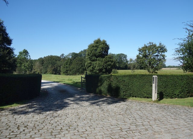
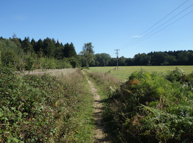
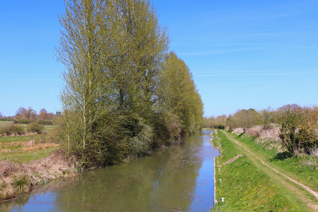
Nature enthusiasts and outdoor lovers will find themselves in paradise in Bedwyn, Great. The surrounding countryside offers a myriad of walking and cycling trails, allowing visitors to explore the breathtaking landscapes. The Kennet and Avon Canal, which runs through the village, offers opportunities for boating, fishing, and peaceful waterside strolls.

Throughout the year, Bedwyn, Great hosts a variety of events and festivals that bring the community together. From summer fetes to Christmas markets, there is always something to enjoy and participate in.

In summary, Bedwyn, Great is a quintessential English village that combines natural beauty, historic charm, and a strong sense of community. Its stunning location, range of amenities, and welcoming atmosphere make it an idyllic place to live or visit.

If you have any feedback on the listing, please let us know in the comments section below.

Bedwyn, Great Images

Images are sourced within 2km of 51.379225/-1.601299 or Grid Reference SU2764. Thanks to Geograph Open Source API. All images are credited.

Farm Gate by the Chapel The medieval St Martin's Chapel is literally in a farmyard, as the gate and concrete yard surface bear out.
This is probably what saved it as it was used as a barn for centuries without being greatly altered and survived to the present day.
Now looked after by English Heritage.
Farm Gate by the Chapel
The medieval St Martin's Chapel is literally in a farmyard, as the gate and concrete yard surface bear out. This is probably what saved it as it was used as a barn for centuries without being greatly altered and survived to the present day. Now looked after by English Heritage.
St Martin's Chapel. West Wall The medieval St Martin's Chapel is literally in a farmyard, as the gate and concrete yard surface show.
This is probably what saved it as it was used as a barn for centuries without being greatly altered and survived to the present day.
Now looked after by English Heritage.
St Martin's Chapel. West Wall
The medieval St Martin's Chapel is literally in a farmyard, as the gate and concrete yard surface show. This is probably what saved it as it was used as a barn for centuries without being greatly altered and survived to the present day. Now looked after by English Heritage.
The way to Chisbury Chapel A track to Chisbury Manor Farm which has the medieval St Martin's Chapel in the farmyard.
The chapel is looked after by English Heritage and access for visitors is on foot along the farm road.
The way to Chisbury Chapel
A track to Chisbury Manor Farm which has the medieval St Martin's Chapel in the farmyard. The chapel is looked after by English Heritage and access for visitors is on foot along the farm road.
Sunflowers at Chisbury Manor Farm A view over the fields on the way to visit the medieval Chapel of St Martin which is in the yard at Manor Farm.
Sunflowers at Chisbury Manor Farm
A view over the fields on the way to visit the medieval Chapel of St Martin which is in the yard at Manor Farm.
Farmland near Chisbury We were here to visit the medieval St Martin's Chapel, an English Heritage site along the farm track behind me.
Visitor numbers are low and there is no special parking place so we just pulled up on the verge here beside Chisbury Lane.
Farmland near Chisbury
We were here to visit the medieval St Martin's Chapel, an English Heritage site along the farm track behind me. Visitor numbers are low and there is no special parking place so we just pulled up on the verge here beside Chisbury Lane.
Digger in the Bracken In a clearing in Castle Copse. Obviously abandoned here for some time, with broken windows and bracken growing up through the cab.
Digger in the Bracken
In a clearing in Castle Copse. Obviously abandoned here for some time, with broken windows and bracken growing up through the cab.
Apples in the Plantation One of several new plantations I passed on my walk today where apple trees have been included in the mix along with oaks and wild cherries and other more usual woodland trees.
Apples in the Plantation
One of several new plantations I passed on my walk today where apple trees have been included in the mix along with oaks and wild cherries and other more usual woodland trees.
Folly Farm Surrounded by fields and woods. This is a view from the bridleway which skirts around the edge of the farm outbuildings.
Folly Farm
Surrounded by fields and woods. This is a view from the bridleway which skirts around the edge of the farm outbuildings.
Road to Folly Farm Also a public bridleway.
Road to Folly Farm
Also a public bridleway.
Burridge Heath Farm A neat and tidy place along a quiet lane.
Burridge Heath Farm
A neat and tidy place along a quiet lane.
Entrance to Foxwood Farm Probably no longer in the agriculture business.
Entrance to Foxwood Farm
Probably no longer in the agriculture business.
Bridleway near Bedwyn Just one of the many paths around this pleasant area of fields and woods all within easy reach of Bedwyn Station.
Bridleway near Bedwyn
Just one of the many paths around this pleasant area of fields and woods all within easy reach of Bedwyn Station.
Frog Lane, Great Bedwyn Did people consciously build beautiful cottages back then, or was there just nothing around to build ugly ones with.
Frog Lane, Great Bedwyn
Did people consciously build beautiful cottages back then, or was there just nothing around to build ugly ones with.
School Lane Dwelling in Little Bedwyn.
School Lane
Dwelling in Little Bedwyn.
Potter's Lock View along the Kennet & Avon canal from the lock.
Potter's Lock
View along the Kennet & Avon canal from the lock.
Buntmill Lock Lock on the Kennet & Avon canal.
Buntmill Lock
Lock on the Kennet & Avon canal.
Hall Grainger & The Pig Killer I found a few more old pictures from the amazing stonemason's museum which used to be in Great Bedwyn until it closed in 2009.
Poor old Hall Grainger only made it to 55, while up above is a bizarre testament to John Higgs.....
"A famous man for killing Pigs.
For killing Pigs was his Delight
Both morning Afternoon and Night
Both heats and Colds he did Endure
Which no Physician did ere Cure
His knife is laid His work is Done
I hope to Heaven his Soul has Gone"
No doubt the pigs would agree.
Hall Grainger & The Pig Killer
I found a few more old pictures from the amazing stonemason's museum which used to be in Great Bedwyn until it closed in 2009. Poor old Hall Grainger only made it to 55, while up above is a bizarre testament to John Higgs..... "A famous man for killing Pigs. For killing Pigs was his Delight Both morning Afternoon and Night Both heats and Colds he did Endure Which no Physician did ere Cure His knife is laid His work is Done I hope to Heaven his Soul has Gone" No doubt the pigs would agree.
Chisbury Lane Crossroads near Little Bedwyn.
Chisbury Lane
Crossroads near Little Bedwyn.
Show me another place!

Bedwyn, Great is located at Grid Ref: SU2764 (Lat: 51.379225, Lng: -1.601299)

Unitary Authority: Wiltshire

Police Authority: Wiltshire

What 3 Words

///dummy.create.digesting. Near Great Bedwyn, Wiltshire

Related Wikis

Great Bedwyn

Great Bedwyn is a village and civil parish in east Wiltshire, England. The village is on the River Dun about 4.5 miles (7.2 km) southwest of Hungerford...

Bedwyn railway station

Bedwyn railway station serves the village of Great Bedwyn in Wiltshire, England. It is 66 miles 33 chains (66.41 mi; 106.9 km) from the zero point at London...

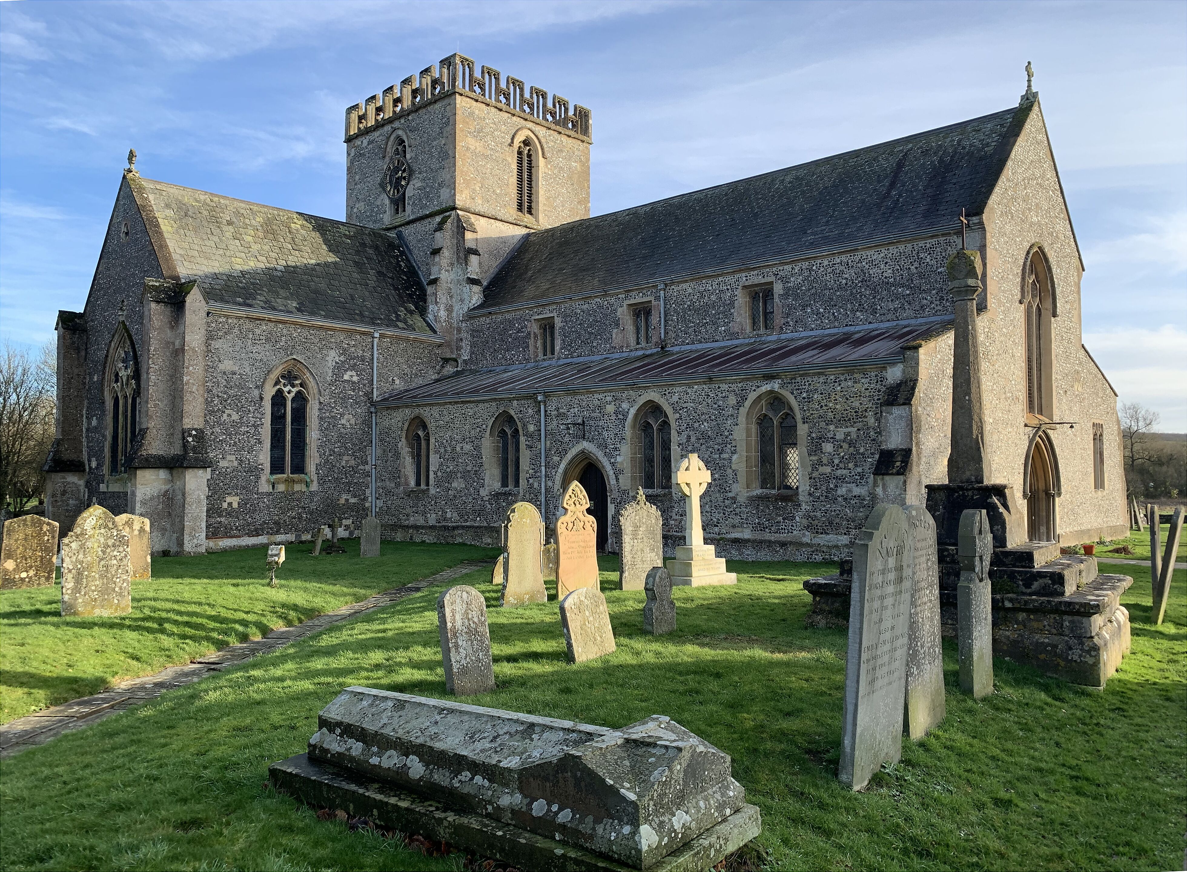
St Mary's Church, Great Bedwyn

The Church of Saint Mary the Virgin is the parish church of Great Bedwyn, Wiltshire, England, and a Grade I listed building. The church was built in the...

Bedwyn Church Lock

Bedwyn Church Lock is on the Kennet and Avon Canal at Great Bedwyn, Wiltshire, England. The lock has a rise/fall of 7 ft 11 in (2.41 m). It is a Grade...

Nearby Amenities

Located within 500m of 51.379225,-1.601299
Bedwyn
Public Transport: stop_position
Railway: stop
Train: yes
Lat/Long: 51.3795509/-1.5988532
Great Bedwyn
Place: village
Lat/Long: 51.379406/-1.601919
Seamark Type: gate
Waterway: lock_gate
Lat/Long: 51.3756552/-1.601624
Crossing
Crossing: unmarked
Tactile Paving: no
Wheelchair: no
Lat/Long: 51.3766613/-1.603551
Barrier: stile
Foot: yes
Material: metal
Source: survey
Stile: squeezer
Lat/Long: 51.3764984/-1.6029212
Post Office
Great Bedwyn Post Office
Addr Postcode: SN8 3PF
Branch: Great Bedwyn
Brand: Post Office
Brand Wikidata: Q1783168
Check Date: 2020-02-20
Contact Website: https://www.postoffice.co.uk/branch-finder/2215489/great-bedwyn
Ref Pol Id: 8295
Wheelchair: yes
Lat/Long: 51.3778917/-1.6027745
Crossing
Crossing: unmarked
Lat/Long: 51.3787562/-1.5993695
Crossing: uncontrolled
Railway: crossing
Lat/Long: 51.3816159/-1.5970173
Entrance: yes
Wheelchair: limited
Wheelchair Description: Step-free and double doors available during services. Only narrow doorway open for other visits. Photos will be added on Wheelmap
Lat/Long: 51.3768306/-1.6028991
Crossing
Crossing: unmarked
Kerb: lowered
Tactile Paving: no
Wheelchair: yes
Lat/Long: 51.3771582/-1.6031615
Bedwyn
Public Transport: stop_position
Railway: stop
Train: yes
Lat/Long: 51.3795657/-1.5988977
Crossing: uncontrolled
Railway: crossing
Lat/Long: 51.3816301/-1.5970625
The Bakery
Disused Shop: bakery
Lat/Long: 51.378629/-1.6016506
Seamark Type: gate
Waterway: lock_gate
Lat/Long: 51.3754678/-1.6018117
Turning Point Type: winding_hole
Waterway: turning_point
Lat/Long: 51.3772173/-1.5996513
Centralkey: crt_watermate
Operator: Canal and River Trust
Waterway: water_point
Lat/Long: 51.3782921/-1.5986452
Waste Disposal
Access: private
Centralkey: crt_watermate
Operator: Canal and River Trust
Lat/Long: 51.378394/-1.5985168
The Stores
Addr City: Great Bedwyn
Addr Housenumber: 19
Addr Postcode: SN8 3NU
Addr Street: High Street
Brand: Londis
Brand Wikidata: Q21008564
Operator: Londis
Shop: convenience
Source: survey
Lat/Long: 51.3792849/-1.6019859
Bus Stop
Railway Station (SW-bound)
Bus: yes
Departures Board: yes
Naptan AtcoCode: 4600WIA13240
Naptan CommonName: Railway Station (SW-bound)
Naptan NaptanCode: wildpapm
Naptan Verified: no
Public Transport: platform
Shelter: no
Source: Nextbus;survey for Wheelmap
Wheelchair: yes
Wheelchair Description: Step-free to/from both station platforms. Part of Loop - No opposite stop, ALL Buses to & from both Hungerford and Marlborough,
Lat/Long: 51.3791255/-1.5996899
Vending Machine
Note: National Rail tickets only
Source: Survey photos for wheelmap Dec 2020
Vending: public_transport_tickets
Wheelchair: yes
Lat/Long: 51.379285/-1.5991778
Shelter
Shelter Type: public_transport
Lat/Long: 51.3793224/-1.5991495
Telephone
Booth: K6
Covered: booth
Description: tourist information inside old red phone box
Listed Status: Grade II
Man Made: telephone_box
Operator: BT
Tourism: information
Lat/Long: 51.3794839/-1.6018888
Historic: memorial
Memorial: war_memorial
Wheelchair: limited
Lat/Long: 51.3770381/-1.6030028
Post Box
Post Box Type: pillar
Ref: SN8 117
Royal Cypher: EIIR
Royal Cypher Wikidata: Q33102113
Lat/Long: 51.377732/-1.6028258
Waste Basket
Lat/Long: 51.3795316/-1.6019427
Post Box
Post Box Type: lamp
Ref: SN8 95D
Royal Cypher: EIIR
Royal Cypher Wikidata: Q33102113
Lat/Long: 51.3791112/-1.6002275
Railway: switch
Lat/Long: 51.3779633/-1.6001986
Railway: switch
Lat/Long: 51.3777651/-1.6004232
Railway: switch
Lat/Long: 51.3773915/-1.6007692
Railway: buffer_stop
Lat/Long: 51.3759647/-1.6020828
Post Box
Post Box Type: lamp
Ref: SN8 148D
Royal Cypher: EIIR
Royal Cypher Wikidata: Q33102113
Lat/Long: 51.3813001/-1.5997204
Bedwyn
Addr City: Great Bedwyn
Addr Street: The Knapp
Internet Access: no
Naptan AtcoCode: 9100BEDYN
Network: National Rail
Network Website: https://www.nationalrail.co.uk/stations/bdw/
Network Wikidata: Q26334
Operator: Great Western Railway
Operator Website: https://www.gwr.com/stations-and-destinations/stations/bedwyn
Operator Wikidata: Q1419438
Public Transport: station
Railway: station
Ref Crs: BDW
Source: NPE
Wheelchair: yes
Wheelchair Description: Wheelchair ramps available. Step-free between platforms via steep ramp from platform 1 (terminating trains) and narrow bridge. Platform 2 (towards Reading & Paddington) has level access from car park and bus stop.
Wikidata: Q2453952
Wikipedia: en:Bedwyn railway station
Lat/Long: 51.3795602/-1.5988756
Cafe
Wendy's Community Cafe & Juice Bar
Lat/Long: 51.3804562/-1.601742
Barrier: kissing_gate
Horse: no
Motor Vehicle: no
Source: survey;aerial imagery
Wheelchair: no
Wheelchair Description: Narrow and restricted dwell space
Lat/Long: 51.3759237/-1.6021476
Barrier: kissing_gate
Horse: no
Motor Vehicle: no
Source: survey;aerial imagery
Wheelchair: no
Wheelchair Description: Narrow and restricted dwell space
Lat/Long: 51.3759347/-1.6018703
Railway: crossing
Lat/Long: 51.3758816/-1.6020182
Railway: crossing
Lat/Long: 51.3758983/-1.6020687
Barrier: bollard
Foot: yes
Lat/Long: 51.3766446/-1.6034863
Bus Stop
St Marys Church (S-bound)
Bus: yes
Departures Board: no
Naptan AtcoCode: 4600WIA13295
Naptan NaptanCode: wildpajp
Public Transport: platform
Shelter: no
Source: Nextbus;survey;streetlevel imagery
Wheelchair: yes
Wheelchair Description: Step-free to opposite stop at Church gate 50m to North
Lat/Long: 51.3766611/-1.6035026
Bus Stop
St Marys Church (N-bound) (Unmarked)
Bus: yes
Departures Board: no
Naptan AtcoCode: 4600WIA13296
Naptan NaptanCode: wildpajd
Public Transport: platform
Shelter: no
Source: Nextbus;survey
Wheelchair: yes
Wheelchair Description: Step-free to opposite stop at Church gate 50m to North
Lat/Long: 51.376689/-1.6035973
Crossing
Crossing: unmarked
Kerb: lowered
Tactile Paving: yes
Wheelchair: yes
Lat/Long: 51.37731/-1.6029773
Crossing
Crossing: unmarked
Kerb: lowered
Tactile Paving: no
Wheelchair: yes
Lat/Long: 51.3763936/-1.6039156
Bus Stop
The Square (S-bound)
Bus: yes
Departures Board: timetable
Naptan AtcoCode: 4600WIA13237
Naptan NaptanCode: wildpamw
Naptan Verified: no
Public Transport: platform
Shelter: no
Source: Nextbus;survey for Wheelmap
Wheelchair: yes
Wheelchair Description: Step-free crossing to station. Cars often obstruct this stop
Lat/Long: 51.379192/-1.6013282
Crossing
Crossing: unmarked
Crossing Island: no
Kerb: lowered
Tactile Paving: yes
Wheelchair: yes
Lat/Long: 51.3792931/-1.6011968
Crossing
Crossing: unmarked
Kerb: lowered
Tactile Paving: yes
Wheelchair: yes
Lat/Long: 51.3790439/-1.6004858
Crossing
Crossing: unmarked
Kerb: lowered
Tactile Paving: yes
Wheelchair: yes
Lat/Long: 51.3789623/-1.6000862
Bench
Source: survey
Lat/Long: 51.3794422/-1.5993506
Crossing
Crossing: unmarked
Note: Pavement flush across side turning
Tactile Paving: no
Wheelchair: yes
Lat/Long: 51.3776777/-1.6029017
Bench
Backrest: yes
Inscription: MARY TOPPING 1949- 2003 Captain of the Juno Head of The Chalet Champion of early years special education Fondly remembered by The Heads of Swindon Special Schools.
Material: wood
Note: Inscription with typos listed on OpenBenches (Location only from my survey photos).
Source: survey
Lat/Long: 51.3754721/-1.6019246
Bench
Backrest: yes
Source: survey
Lat/Long: 51.375601/-1.6018186
Bus Stop
Three Tuns
Bus: yes
Departures Board: no
Naptan AtcoCode: 460000242
Naptan NaptanCode: wildwmja
Public Transport: platform
Shelter: no
Source: streetlevel imagery;aerial imagery
Wheelchair: limited
Wheelchair Description: short platform footway with kerbs
Lat/Long: 51.3799948/-1.6036548
Bus Stop
Three Tuns
Bus: yes
Naptan AtcoCode: 460000192
Naptan NaptanCode: wildwmtg
Public Transport: platform
Source: Nextbus;streetlevel imagery
Wheelchair: limited
Wheelchair Description: narrow footway and kerbs
Lat/Long: 51.3801032/-1.603795
Grit Bin
Material: plastic
Source: Survey photos for wheelmap Dec 2020;aerial imagery
Lat/Long: 51.3789759/-1.5992893
Sanitary Dump Station
Network: Canal & River Trust
Sanitary Dump Station Basin: yes
Lat/Long: 51.3783787/-1.5984772
Sanitary Dump Station
Sanitary Dump Station Pump-out: yes
Lat/Long: 51.3783201/-1.5986502
GWR
Boundary: marker
Fixme: Inscription needs verification
Inscription: Great Western Railways
Material: metal
Lat/Long: 51.3813716/-1.5975043
Bench
Lat/Long: 51.3795582/-1.6020101
Street Lamp
Lat/Long: 51.3792446/-1.6014951
Information: guidepost
Tourism: information
Lat/Long: 51.3792535/-1.6014397
The data included in this document is from www.openstreetmap.org. The data is made available under ODbL.

Have you been to Bedwyn, Great?

Leave your review of Bedwyn, Great below (or comments, questions and feedback).