Bavington, Great
Settlement in Northumberland
England
Bavington, Great
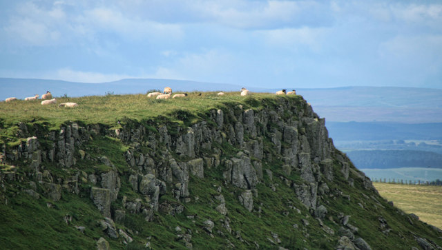
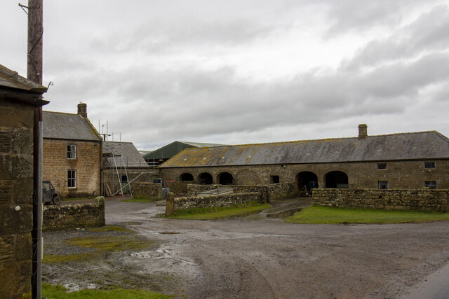
![Disused limestone quarry, north of Quarry House "Firstly, at the east of this part of the area, is a limekiln [site 12] which is also marked on the Thockrington Tithe Map of 1844. No kiln is marked on the site in the Second Edition Ordnance Survey Map (1898) - indicating that it was disused by that date - but the map indicates a quarry adjacent and to the east of the site of the limekiln. This quarry would have been the source of limestone when the kiln was operating. Today, the limekiln appears only as a grassy mound, although the ramp which was used for loading the kiln is evident on the south side. No arch (from which the lime was drawn) is now visible, but it is likely that at least one drawing arch was originally located at the foot of the north side of the kiln, facing the modern tarmac road."
A Field Survey at Quarry House and North Heugh Farms, Northumberland.
P.C. Sellers and D.H. Prothero (1991). Northern Archaeology Vol.11 p.57-72.](https://s2.geograph.org.uk/geophotos/07/40/29/7402902_73839b2c.jpg)
Bavington, Great is a small village located in the county of Northumberland, in the northeast region of England. Situated in the Tyne Valley and surrounded by picturesque countryside, Bavington offers a tranquil and idyllic setting for its residents. The village is part of the civil parish of Kirkheaton and is approximately 20 miles west of the city of Newcastle upon Tyne.
Known for its rich history, Bavington can trace its roots back to medieval times when it was mentioned in historical records as a settlement with strong agricultural ties. Today, the village retains its rural charm and is home to a close-knit community of residents.
Bavington is primarily an agricultural community, with farming playing a significant role in the local economy. The village is characterized by its rolling green fields, dotted with livestock and crops, creating a picturesque backdrop for its residents and visitors alike.
While Bavington is predominantly a residential area, it does offer a few amenities to its residents. These include a village hall, where various community events and gatherings take place, as well as a local pub, providing a social hub for villagers to relax and socialize.
For those seeking outdoor activities, Bavington is surrounded by beautiful countryside, offering ample opportunities for walking, hiking, and exploring nature. The nearby Northumberland National Park and Hadrian's Wall are popular destinations for outdoor enthusiasts.
Overall, Bavington, Great is a charming and peaceful village, perfect for those seeking a quiet and rural lifestyle amidst the beauty of the Northumberland countryside.
If you have any feedback on the listing, please let us know in the comments section below.
Bavington, Great Images
Images are sourced within 2km of 55.117277/-2.026964 or Grid Reference NY9880. Thanks to Geograph Open Source API. All images are credited.


Bavington, Great is located at Grid Ref: NY9880 (Lat: 55.117277, Lng: -2.026964)
Unitary Authority: Northumberland
Police Authority: Northumbria
What 3 Words
///increases.pulp.sensitive. Near Rothley, Northumberland
Nearby Locations
Related Wikis

Bavington Crags
Bavington Crags is a Site of Special Scientific Interest (SSSI) in north Northumberland, England. The site is an outcropping of the Whin Sill which gives...

Bavington Hall
Bavington Hall is a 17th-century privately owned country house at Little Bavington in Northumberland. It is a Grade II* listed building.A tower house...
Bavington
Bavington is a civil parish in Northumberland, England. The parish includes the villages of Great Bavington, Little Bavington and Thockrington. According...

Thockrington
Thockrington is a village and former civil parish, now in the parish of Bavington, in Northumberland, England. The village lies about 10 miles (16 km)...

Kirkharle Hall
Kirkharle Hall was a country house at Kirkharle, Northumberland, England, the former seat of the Loraine family, now much reduced and in use as a farmhouse...
Kirkharle
Kirkharle (otherwise Kirk Harle) is a village and former civil parish, now in the parish of Kirkwhelpington, in the county of Northumberland in Northern...
Kirkheaton, Northumberland
Kirkheaton (English: ) is a village and former civil parish, now in the parish of Capheaton, in the county of Northumberland, England. The village lies...

Hallington Reservoirs
Hallington Reservoirs are located near the small village of Colwell, Northumberland, England on the B6342 road off the A68 road, and 7 miles (11 km) north...
Nearby Amenities
Located within 500m of 55.117277,-2.026964Have you been to Bavington, Great?
Leave your review of Bavington, Great below (or comments, questions and feedback).