Newton Tarn

Lake, Pool, Pond, Freshwater Marsh in Lancashire South Lakeland

England

Newton Tarn

A590 eastbound at Ayside
A590 eastbound at Ayside Credit: Colin Pyle

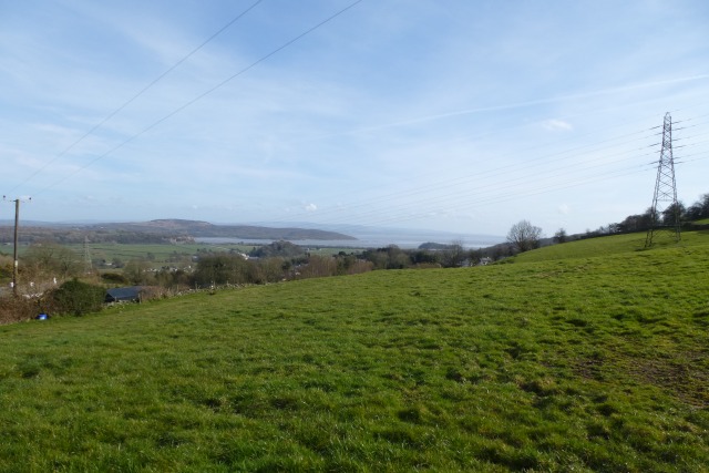
Newton Tarn is a picturesque body of water located in the county of Lancashire, England. Situated amidst the stunning countryside, this natural feature is renowned for its tranquil and idyllic setting, attracting visitors from near and far.

The tarn itself is a small lake, encompassing an area of approximately 4 acres. It is nestled within a valley, surrounded by rolling hills and verdant greenery, creating a breathtaking backdrop for nature lovers and photographers alike. The water in Newton Tarn is crystal clear, reflecting the beauty of its surroundings and offering a serene atmosphere.

The tarn is home to a diverse range of flora and fauna, making it a haven for wildlife enthusiasts. The surrounding vegetation includes reeds, rushes, and water lilies, providing a habitat for various bird species, such as ducks, swans, and herons. Visitors can often spot these graceful creatures gliding across the water or nesting in the nearby trees.

Additionally, Newton Tarn is a popular spot for fishing enthusiasts. The lake is stocked with a variety of freshwater fish, including trout and perch, making it an ideal location for anglers to cast their lines and enjoy a day of fishing.

For those who prefer to simply immerse themselves in the tranquility of nature, there are several walking trails that meander around the tarn, offering breathtaking views and opportunities to spot other wildlife such as deer and rabbits. The area also boasts a picnic spot where visitors can relax and enjoy a meal while taking in the beauty of Newton Tarn.

In conclusion, Newton Tarn is a delightful freshwater feature situated in Lancashire's countryside. With its serene atmosphere, diverse wildlife, and scenic surroundings, it is a haven for nature lovers and offers a peaceful retreat from the hustle and bustle of daily life.

If you have any feedback on the listing, please let us know in the comments section below.

Newton Tarn Images

Images are sourced within 2km of 54.236009/-2.9091807 or Grid Reference SD4082. Thanks to Geograph Open Source API. All images are credited.

A590 eastbound at Ayside
View across the fields from Old Town Hill
High and Low Newton By-pass The A590 north of Grange-Over-Sands
High and Low Newton By-pass
The A590 north of Grange-Over-Sands
Farmland above Lindale Looking towards the coast from a road above Lindale.
Farmland above Lindale
Looking towards the coast from a road above Lindale.
Hollow Lane Looking along Hollow Lane near the B5271 junction.
Hollow Lane
Looking along Hollow Lane near the B5271 junction.
Sheep off Hollow Lane Looking across farmland above Lindale.
Sheep off Hollow Lane
Looking across farmland above Lindale.
Hollow Lane Looking along Hollow Lane above Lindale.
Hollow Lane
Looking along Hollow Lane above Lindale.
Hedgerow along Hollow Lane Looking along Hollow Lane between Cartmel Lane and the B5271.
Hedgerow along Hollow Lane
Looking along Hollow Lane between Cartmel Lane and the B5271.
Hungry sheep beside Hollow Lane Sheep all gathered eating by the edge of the field.
Hungry sheep beside Hollow Lane
Sheep all gathered eating by the edge of the field.
Sheep feeding Sheep busy feeding beside Hollow Lane.
Sheep feeding
Sheep busy feeding beside Hollow Lane.
Fields off Old Town Hill Looking over fields from Old Town Hill with Great Wood behind.
Fields off Old Town Hill
Looking over fields from Old Town Hill with Great Wood behind.
Farm bridge over A590 south of Low Newton The A590 is a 34 mile long trunk road in southern Cumbria. It runs north-east to south-west from M6 junction 36, through the towns of Ulverston and Barrow-in-Furness to terminate at Vickerstown on Walney Island.
Farm bridge over A590 south of Low Newton
The A590 is a 34 mile long trunk road in southern Cumbria. It runs north-east to south-west from M6 junction 36, through the towns of Ulverston and Barrow-in-Furness to terminate at Vickerstown on Walney Island.
Lay-by on A590 near Low Newton Including the Pink A590 Pit-stop snack bar trailer
Lay-by on A590 near Low Newton
Including the Pink A590 Pit-stop snack bar trailer
Former A590 from Low Newton Traffic on the former A590 road which ran through the villages of High Newton and Low Newton has fallen considerably since the (new A590) bypass road was opened in 2008 (<span class="nowrap"><a title="https://www.gov.uk/government/news/big-journey-savings-and-safety-boost-from-a590-bypass-in-cumbria" rel="nofollow ugc noopener" href="https://www.gov.uk/government/news/big-journey-savings-and-safety-boost-from-a590-bypass-in-cumbria">Link</a><img style="margin-left:2px;" alt="External link" title="External link - shift click to open in new window" src="https://s1.geograph.org.uk/img/external.png" width="10" height="10"/></span>  Gov.uk)
Former A590 from Low Newton
Traffic on the former A590 road which ran through the villages of High Newton and Low Newton has fallen considerably since the (new A590) bypass road was opened in 2008 (LinkExternal link Gov.uk)
Approaching Low Newton Approaching Low Newton on the former A590. Traffic on this road which runs through the villages of High Newton and Low Newton has fallen considerably since the (new A590) 2½-mile bypass was opened in 2008 (<span class="nowrap"><a title="https://www.gov.uk/government/news/big-journey-savings-and-safety-boost-from-a590-bypass-in-cumbria" rel="nofollow ugc noopener" href="https://www.gov.uk/government/news/big-journey-savings-and-safety-boost-from-a590-bypass-in-cumbria">Link</a><img style="margin-left:2px;" alt="External link" title="External link - shift click to open in new window" src="https://s1.geograph.org.uk/img/external.png" width="10" height="10"/></span>  Gov.uk)
Approaching Low Newton
Approaching Low Newton on the former A590. Traffic on this road which runs through the villages of High Newton and Low Newton has fallen considerably since the (new A590) 2½-mile bypass was opened in 2008 (LinkExternal link Gov.uk)
Former A590 Road towards Low Newton Traffic on the former A590 road which ran through the villages of High Newton and Low Newton has fallen considerably since the (new A590) bypass road was opened in 2008 (<span class="nowrap"><a title="https://www.gov.uk/government/news/big-journey-savings-and-safety-boost-from-a590-bypass-in-cumbria" rel="nofollow ugc noopener" href="https://www.gov.uk/government/news/big-journey-savings-and-safety-boost-from-a590-bypass-in-cumbria">Link</a><img style="margin-left:2px;" alt="External link" title="External link - shift click to open in new window" src="https://s1.geograph.org.uk/img/external.png" width="10" height="10"/></span>  Gov.uk)
Former A590 Road towards Low Newton
Traffic on the former A590 road which ran through the villages of High Newton and Low Newton has fallen considerably since the (new A590) bypass road was opened in 2008 (LinkExternal link Gov.uk)
Tom Tarn, below Dixon Heights
The A590 at Eller How About 2.5 miles of the A590, from here to Whitestone, was upgraded to dual carriageway in 2008.
The A590 at Eller How
About 2.5 miles of the A590, from here to Whitestone, was upgraded to dual carriageway in 2008.
Show me another place!

Newton Tarn is located at Grid Ref: SD4082 (Lat: 54.236009, Lng: -2.9091807)

Administrative County: Cumbria

District: South Lakeland

Police Authority: Cumbria

What 3 Words

///bagpipes.toothpick.banks. Near Grange-over-Sands, Cumbria

Related Wikis

Low Newton, Cumbria

Low Newton (originally Nether Newton) is a hamlet in the South Lakeland District, in the county of Cumbria, England and in the Lake District also commonly...

Newton Fell

Newton Fell is a hill in the English Lake District near High Newton, south east of Newby Bridge, Cumbria. It lies to the north east of the A590 road. It...

High Newton

High Newton is a village in the South Lakeland district, in the county of Cumbria, England. == By-pass == Formerly, the village was bisected by the A590...

Barber Green

Barber Green is a village in Cumbria, England.

Ayside

Ayside is a hamlet on the A590 road, in the South Lakeland district, in the county of Cumbria, England. == References == Philip's Street Atlas Cumbria...

Hampsfield House

Hampsfield House is a country house located to the west of the village of Lindale, Cumbria, England. It was built between 1880 and 1882, and designed...

St Peter's Church, Field Broughton

St Peter's Church is in the village of Field Broughton, Cumbria, England. It is an active Anglican parish church in the deanery of Windermere, the archdeaconry...

Field Broughton

Field Broughton is a village in the South Lakeland district of the English county of Cumbria. The village forms part of the civil parish of Broughton East...

Nearby Amenities

Located within 500m of 54.236009,-2.9091807
Ele: 221
Is In Country Code: GB
Is In County: Cumbria
Natural: peak
Source: NPE
Lat/Long: 54.2377581/-2.9094308
Low Newton
Is In Country Code: GB
Is In County: Cumbria
Is In Historic County: Lancashire
Place: hamlet
Wikidata: Q6692926
Lat/Long: 54.2322715/-2.913287
Power: pole
Lat/Long: 54.234134/-2.9140635
Power: pole
Lat/Long: 54.2337206/-2.9141679
Power: pole
Lat/Long: 54.2333156/-2.9142913
Post Box
Ref: LA11 144
Lat/Long: 54.2332097/-2.9134388
Bus Stop
Yewtree Barn
Bus: yes
Naptan AtcoCode: 090079034810
Public Transport: platform
Lat/Long: 54.2331987/-2.9134479
Yewtree Barn
Bus: yes
Public Transport: stop_position
Lat/Long: 54.2332032/-2.9133219
Bus Stop
Yewtree Barn
Bus: yes
Naptan AtcoCode: 90079034811
Public Transport: platform
Lat/Long: 54.2327683/-2.9131779
Yewtree Barn
Bus: yes
Public Transport: stop_position
Lat/Long: 54.232773/-2.9132815
Yew Tree Barn
Addr City: Low Newton
Addr Postcode: LA11 6JP
Shop: antiques
Website: https://yewtreebarn.co.uk/
Lat/Long: 54.2332339/-2.9139871
Cafe
Lat/Long: 54.2331862/-2.9137612
The data included in this document is from www.openstreetmap.org. The data is made available under ODbL.

Have you been to Newton Tarn?

Leave your review of Newton Tarn below (or comments, questions and feedback).