Monks Pool

Lake, Pool, Pond, Freshwater Marsh in Denbighshire

Wales

Monks Pool

Ruabon station
Ruabon station Credit: Roy Hughes

Monks Pool is a picturesque freshwater marsh located in Denbighshire, Wales. Spread over an area of approximately 5 acres, it is often referred to as a lake, pool, or pond due to its size and tranquility. The pool is tucked away amidst rolling green hills and is surrounded by dense vegetation, creating a serene and natural ambiance.

The water in Monks Pool is crystal clear and fed by a small stream that originates from the nearby hills. It is home to a diverse range of aquatic plants and serves as a habitat for various species of fish, amphibians, and insects. The pool's calm and undisturbed nature make it an ideal breeding ground for many aquatic creatures.

The surrounding area of Monks Pool is abundant with wildlife, including a variety of birds such as ducks, swans, and herons. These avian species are often seen gliding gracefully across the water or nesting in the surrounding trees. The pool's tranquil environment also attracts other wildlife enthusiasts, who come to observe and study the diverse flora and fauna that thrive in this unique ecosystem.

Monks Pool is a popular spot for nature lovers and photographers, who are drawn to its natural beauty and peaceful atmosphere. Its remote location and quiet surroundings make it an ideal place for relaxation and contemplation, away from the hustle and bustle of urban life.

Overall, Monks Pool in Denbighshire is a hidden gem, offering a glimpse into the beauty and diversity of Wales' natural landscapes.

If you have any feedback on the listing, please let us know in the comments section below.

Monks Pool Images

Images are sourced within 2km of 52.996203/-3.0391554 or Grid Reference SJ3044. Thanks to Geograph Open Source API. All images are credited.

Ruabon station
Ruabon station
Railway bridge over the B5605 North of Ruabon station.
Railway bridge over the B5605
North of Ruabon station.
The Wynnstay Arms Hotel in the centre of Ruabon.
The Wynnstay Arms
Hotel in the centre of Ruabon.
Stryt Fawr, Rhiwabon Ruabon's High Street, once the very busy main A483, now something of a backwater.
Stryt Fawr, Rhiwabon
Ruabon's High Street, once the very busy main A483, now something of a backwater.
Rhiwabon Nowhere is the brilliant red Ruabon brick better shown off than in its home village on a bright early spring morning.
Rhiwabon
Nowhere is the brilliant red Ruabon brick better shown off than in its home village on a bright early spring morning.
Old avenue from Wynnstay Hall to Ruabon An avenue connecting Wynnstay and its estate village of Ruabon was planted c.1777. After the Williams-Wynn family left the house in 1948, the avenue was increasingly neglected, and in the late 1980s was severed by the new A483 Wrexham/Ruabon by-pass.
Old avenue from Wynnstay Hall to Ruabon
An avenue connecting Wynnstay and its estate village of Ruabon was planted c.1777. After the Williams-Wynn family left the house in 1948, the avenue was increasingly neglected, and in the late 1980s was severed by the new A483 Wrexham/Ruabon by-pass.
Old circular AA sign in the Bridge End, Ruabon Old AA Sign located in the Bridge End PH on the northwest side of the B5605 Bridge Street, Ruabon. Ruabon community.

This is the Circular, village name on black band, no Motor Union symbol or name type, dating from 1923 showing distances Wrexham 5¼ Llangollen 6 London 180. 

There were five series of AA signs, mostly dating from 1923 and made by Francis & Co / Franco in Deptford, London. The village name and distance to London or Dublin were normally displayed.

Milestone Society National ID: DEN-RUABON
Old circular AA sign in the Bridge End, Ruabon
Old AA Sign located in the Bridge End PH on the northwest side of the B5605 Bridge Street, Ruabon. Ruabon community. This is the Circular, village name on black band, no Motor Union symbol or name type, dating from 1923 showing distances Wrexham 5¼ Llangollen 6 London 180. There were five series of AA signs, mostly dating from 1923 and made by Francis & Co / Franco in Deptford, London. The village name and distance to London or Dublin were normally displayed. Milestone Society National ID: DEN-RUABON
Rontec services, Ruabon Bypass The A483 is a major north-south trunk road in Wales, running for 149 miles between Chester and Junction 42 of the M4 motorway just east of Swansea.
<span class="nowrap"><a title="http://www.sabre-roads.org.uk/wiki/index.php?title=A483" rel="nofollow ugc noopener" href="http://www.sabre-roads.org.uk/wiki/index.php?title=A483">Link</a><img style="margin-left:2px;" alt="External link" title="External link - shift click to open in new window" src="https://s1.geograph.org.uk/img/external.png" width="10" height="10"/></span>  SABRE
<span class="nowrap"><a title="https://en.wikipedia.org/wiki/A483_road" rel="nofollow ugc noopener" href="https://en.wikipedia.org/wiki/A483_road">Link</a><img style="margin-left:2px;" alt="External link" title="External link - shift click to open in new window" src="https://s1.geograph.org.uk/img/external.png" width="10" height="10"/></span>  Wikipedia
Rontec services, Ruabon Bypass
The A483 is a major north-south trunk road in Wales, running for 149 miles between Chester and Junction 42 of the M4 motorway just east of Swansea. LinkExternal link SABRE LinkExternal link Wikipedia
A483, Ruabon Bypass The A483 is a major north-south trunk road in Wales, running for 149 miles between Chester and Junction 42 of the M4 motorway just east of Swansea.
<span class="nowrap"><a title="http://www.sabre-roads.org.uk/wiki/index.php?title=A483" rel="nofollow ugc noopener" href="http://www.sabre-roads.org.uk/wiki/index.php?title=A483">Link</a><img style="margin-left:2px;" alt="External link" title="External link - shift click to open in new window" src="https://s1.geograph.org.uk/img/external.png" width="10" height="10"/></span>  SABRE
<span class="nowrap"><a title="https://en.wikipedia.org/wiki/A483_road" rel="nofollow ugc noopener" href="https://en.wikipedia.org/wiki/A483_road">Link</a><img style="margin-left:2px;" alt="External link" title="External link - shift click to open in new window" src="https://s1.geograph.org.uk/img/external.png" width="10" height="10"/></span>  Wikipedia
A483, Ruabon Bypass
The A483 is a major north-south trunk road in Wales, running for 149 miles between Chester and Junction 42 of the M4 motorway just east of Swansea. LinkExternal link SABRE LinkExternal link Wikipedia
Bridge over the A483 at Ruabon The A483 is a major north-south trunk road in Wales, running for 149 miles between Chester and Junction 42 of the M4 motorway just east of Swansea.
<span class="nowrap"><a title="http://www.sabre-roads.org.uk/wiki/index.php?title=A483" rel="nofollow ugc noopener" href="http://www.sabre-roads.org.uk/wiki/index.php?title=A483">Link</a><img style="margin-left:2px;" alt="External link" title="External link - shift click to open in new window" src="https://s1.geograph.org.uk/img/external.png" width="10" height="10"/></span>  SABRE
<span class="nowrap"><a title="https://en.wikipedia.org/wiki/A483_road" rel="nofollow ugc noopener" href="https://en.wikipedia.org/wiki/A483_road">Link</a><img style="margin-left:2px;" alt="External link" title="External link - shift click to open in new window" src="https://s1.geograph.org.uk/img/external.png" width="10" height="10"/></span>  Wikipedia
Bridge over the A483 at Ruabon
The A483 is a major north-south trunk road in Wales, running for 149 miles between Chester and Junction 42 of the M4 motorway just east of Swansea. LinkExternal link SABRE LinkExternal link Wikipedia
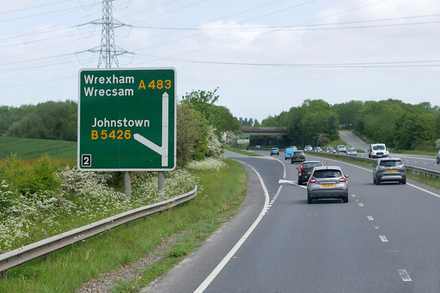
Northbound A483 at Junction 2 The A5 is a major trunk road which runs for about 181 miles from London, in England, to Holyhead, in Wales. For part of its route, it follows a section of the Roman route which later took the Anglo-Saxon name Watling Street.  At Oswestry, the A5 joins the A483 and becomes the bypass to the east of the town. It continues to multiplex with the A483 until it reaches Halton, where it diverges towards Llangollen and Holyhead.
Northbound A483 at Junction 2
The A5 is a major trunk road which runs for about 181 miles from London, in England, to Holyhead, in Wales. For part of its route, it follows a section of the Roman route which later took the Anglo-Saxon name Watling Street. At Oswestry, the A5 joins the A483 and becomes the bypass to the east of the town. It continues to multiplex with the A483 until it reaches Halton, where it diverges towards Llangollen and Holyhead.
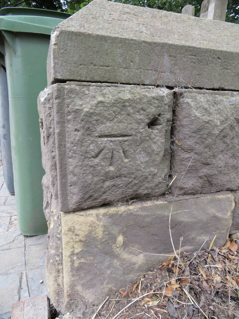
Benchmark in Vincent Street, Ruabon Ordnance Survey benchmark in Vincent Street, Ruabon. Levelled at 116.482m above Newlyn datum, verified in 1960. For a wider view see: <a href="https://www.geograph.org.uk/photo/7540804">SJ3044 : The former County Constabulary building, New High Street</a> Benchmark database: <span class="nowrap"><a title="https://www.bench-marks.org.uk/bm197092" rel="nofollow ugc noopener" href="https://www.bench-marks.org.uk/bm197092">Link</a><img style="margin-left:2px;" alt="External link" title="External link - shift click to open in new window" src="https://s1.geograph.org.uk/img/external.png" width="10" height="10"/></span>
Benchmark in Vincent Street, Ruabon
Ordnance Survey benchmark in Vincent Street, Ruabon. Levelled at 116.482m above Newlyn datum, verified in 1960. For a wider view see: SJ3044 : The former County Constabulary building, New High Street Benchmark database: LinkExternal link
The former County Constabulary building, New High Street Looking across New High Street towards the former County Constabulary building, which is dated 1898. There is an Ordnance Survey benchmark on the side wall behind the white car: <a href="https://www.geograph.org.uk/photo/7540783">SJ3044 : Benchmark in Vincent Street, Ruabon</a>
The former County Constabulary building, New High Street
Looking across New High Street towards the former County Constabulary building, which is dated 1898. There is an Ordnance Survey benchmark on the side wall behind the white car: SJ3044 : Benchmark in Vincent Street, Ruabon
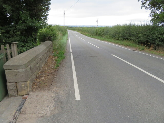
Benchmark on Black Brook Bridge Ordnance Survey benchmark on Black Brook Bridge parapet alongside the B5426, east of Rhosllanerchrugog. Levelled at 92.162m above Newlyn Datum, verified 1959. For a wider view see: <a href="https://www.geograph.org.uk/photo/7541558">SJ3245 : The B5426 over Black Brook Bridge</a>  Benchmark database: <span class="nowrap"><a title="https://www.bench-marks.org.uk/bm197126" rel="nofollow ugc noopener" href="https://www.bench-marks.org.uk/bm197126">Link</a><img style="margin-left:2px;" alt="External link" title="External link - shift click to open in new window" src="https://s1.geograph.org.uk/img/external.png" width="10" height="10"/></span>
Benchmark on Black Brook Bridge
Ordnance Survey benchmark on Black Brook Bridge parapet alongside the B5426, east of Rhosllanerchrugog. Levelled at 92.162m above Newlyn Datum, verified 1959. For a wider view see: SJ3245 : The B5426 over Black Brook Bridge Benchmark database: LinkExternal link
The B5426 over Black Brook Bridge Looking west across Black Brook Bridge, east of Rhosllanerchrugog. There is an Ordnance Survey benchmark on the corner of the bridge parapet on the left: <a href="https://www.geograph.org.uk/photo/7541548">SJ3245 : Benchmark on Black Brook Bridge</a>
The B5426 over Black Brook Bridge
Looking west across Black Brook Bridge, east of Rhosllanerchrugog. There is an Ordnance Survey benchmark on the corner of the bridge parapet on the left: SJ3245 : Benchmark on Black Brook Bridge
A539 looking west from A483 slip road The slip road leaves the A438 here at the Ruabon junction.
A539 looking west from A483 slip road
The slip road leaves the A438 here at the Ruabon junction.
Exit from James Farm caravan site At junction with A539
Exit from James Farm caravan site
At junction with A539
Bench mark on Pont Adam, Ruabon This bench mark is on the north parapet of the old stone bridge, Pont Adam, that carries the B5079, also called Pont Adam, over the Afon Eitha. The mark was recorded on the 1874 O.S. map, levelled at 379.5 feet. See also <a href="https://www.geograph.org.uk/photo/2595312">SJ3043 : Pont Adam and a bench mark</a>
Bench mark on Pont Adam, Ruabon
This bench mark is on the north parapet of the old stone bridge, Pont Adam, that carries the B5079, also called Pont Adam, over the Afon Eitha. The mark was recorded on the 1874 O.S. map, levelled at 379.5 feet. See also SJ3043 : Pont Adam and a bench mark
Show me another place!

Monks Pool is located at Grid Ref: SJ3044 (Lat: 52.996203, Lng: -3.0391554)

Unitary Authority: Wrexham

Police Authority: North Wales

What 3 Words

///saying.subsets.beginning. Near Ruabon, Wrexham

Related Wikis

Wynnville Halt railway station

Wynnville Halt was a small railway halt located on the Shrewsbury to Chester Line less than a mile north of Ruabon station in Wales. It was opened by the...

Ruabon Grammar School

Ruabon Grammar School was situated in Ruabon, Denbighshire in north-east Wales. It provided a grammar school education to boys in the parishes of Ruabon...

Lindisfarne College

Lindisfarne College was a private school or independent school. It was founded in 1891 in Westcliff-on-Sea in Essex, England. In 1940 Lindisfarne College...

Ysgol Rhiwabon

Ysgol Rhiwabon (Welsh for 'Ruabon School') is a comprehensive school in Ruabon, Wrexham, Wales for 11- to 16-year-olds. The headteacher is Melanie Ferron...

Nearby Amenities

Located within 500m of 52.996203,-3.0391554
Mini Roundabout
Lat/Long: 52.9945175/-3.0347923
Clwyd Breakers
Industrial: auto_wrecker
Lat/Long: 52.9972543/-3.0434085
Bus Stop
Bus: yes
Naptan AtcoCode: 5140AWD70625
Naptan NaptanCode: wrejama
Public Transport: platform
Lat/Long: 52.9919188/-3.0380459
Bus Stop
Bus: yes
Naptan AtcoCode: 5140WRX02131
Naptan NaptanCode: wregatj
Public Transport: platform
Lat/Long: 52.999071/-3.0419518
Direction: 190
Generator Method: photovoltaic
Generator Output Electricity: yes
Generator Solar Modules: 17
Generator Source: solar
Generator Type: solar_photovoltaic_panel
Location: roof
Power: generator
Lat/Long: 52.9946834/-3.036802
Direction: 190
Generator Method: photovoltaic
Generator Output Electricity: yes
Generator Solar Modules: 7
Generator Source: solar
Generator Type: solar_photovoltaic_panel
Location: roof
Power: generator
Lat/Long: 52.9946999/-3.0369737
Direction: 190
Generator Method: photovoltaic
Generator Output Electricity: yes
Generator Solar Modules: 9
Generator Source: solar
Generator Type: solar_photovoltaic_panel
Location: roof
Power: generator
Lat/Long: 52.9944844/-3.0361509
Direction: 190
Generator Method: photovoltaic
Generator Output Electricity: yes
Generator Solar Modules: 9
Generator Source: solar
Generator Type: solar_photovoltaic_panel
Location: roof
Power: generator
Lat/Long: 52.994478/-3.0360704
Direction: 190
Generator Method: photovoltaic
Generator Output Electricity: yes
Generator Solar Modules: 14
Generator Source: solar
Generator Type: solar_photovoltaic_panel
Location: roof
Power: generator
Lat/Long: 52.9942362/-3.0362796
Direction: 190
Generator Method: photovoltaic
Generator Output Electricity: yes
Generator Solar Modules: 8
Generator Source: solar
Generator Type: solar_photovoltaic_panel
Location: roof
Power: generator
Lat/Long: 52.9941829/-3.0357871
Direction: 190
Generator Method: photovoltaic
Generator Output Electricity: yes
Generator Solar Modules: 12
Generator Source: solar
Generator Type: solar_photovoltaic_panel
Location: roof
Power: generator
Lat/Long: 52.994888/-3.0359932
Direction: 190
Generator Method: photovoltaic
Generator Output Electricity: yes
Generator Solar Modules: 7
Generator Source: solar
Generator Type: solar_photovoltaic_panel
Location: roof
Power: generator
Lat/Long: 52.9948743/-3.0358833
Direction: 190
Generator Method: photovoltaic
Generator Output Electricity: yes
Generator Solar Modules: 15
Generator Source: solar
Generator Type: solar_photovoltaic_panel
Location: roof
Power: generator
Lat/Long: 52.9948513/-3.0356111
Direction: 190
Generator Method: photovoltaic
Generator Output Electricity: yes
Generator Solar Modules: 9
Generator Source: solar
Generator Type: solar_photovoltaic_panel
Location: roof
Power: generator
Lat/Long: 52.9948197/-3.0353402
Direction: 190
Generator Method: photovoltaic
Generator Output Electricity: yes
Generator Solar Modules: 9
Generator Source: solar
Generator Type: solar_photovoltaic_panel
Location: roof
Power: generator
Lat/Long: 52.9948101/-3.035255
Direction: 190
Generator Method: photovoltaic
Generator Output Electricity: yes
Generator Solar Modules: 7
Generator Source: solar
Generator Type: solar_photovoltaic_panel
Location: roof
Power: generator
Lat/Long: 52.9940085/-3.0366431
Direction: 190
Generator Method: photovoltaic
Generator Output Electricity: yes
Generator Solar Modules: 7
Generator Source: solar
Generator Type: solar_photovoltaic_panel
Location: roof
Power: generator
Lat/Long: 52.994015/-3.0367396
Direction: 190
Generator Method: photovoltaic
Generator Output Electricity: yes
Generator Solar Modules: 8
Generator Source: solar
Generator Type: solar_photovoltaic_panel
Location: roof
Power: generator
Lat/Long: 52.9940352/-3.0369421
Direction: 190
Generator Method: photovoltaic
Generator Output Electricity: yes
Generator Solar Modules: 7
Generator Source: solar
Generator Type: solar_photovoltaic_panel
Location: roof
Power: generator
Lat/Long: 52.9940513/-3.0371433
Direction: 190
Generator Method: photovoltaic
Generator Output Electricity: yes
Generator Solar Modules: 9
Generator Source: solar
Generator Type: solar_photovoltaic_panel
Location: roof
Power: generator
Lat/Long: 52.9940245/-3.0368402
Direction: 175
Generator Method: photovoltaic
Generator Output Electricity: yes
Generator Solar Modules: 7
Generator Source: solar
Generator Type: solar_photovoltaic_panel
Location: roof
Power: generator
Lat/Long: 52.9937662/-3.0364043
Direction: 175
Generator Method: photovoltaic
Generator Output Electricity: yes
Generator Solar Modules: 7
Generator Source: solar
Generator Type: solar_photovoltaic_panel
Location: roof
Power: generator
Lat/Long: 52.9937589/-3.0365129
Direction: 175
Generator Method: photovoltaic
Generator Output Electricity: yes
Generator Solar Modules: 7
Generator Source: solar
Generator Type: solar_photovoltaic_panel
Location: roof
Power: generator
Lat/Long: 52.9937476/-3.036651
Direction: 175
Generator Method: photovoltaic
Generator Output Electricity: yes
Generator Solar Modules: 7
Generator Source: solar
Generator Type: solar_photovoltaic_panel
Location: roof
Power: generator
Lat/Long: 52.9937412/-3.0367771
Direction: 175
Generator Method: photovoltaic
Generator Output Electricity: yes
Generator Solar Modules: 7
Generator Source: solar
Generator Type: solar_photovoltaic_panel
Location: roof
Power: generator
Lat/Long: 52.9935571/-3.036356
Direction: 175
Generator Method: photovoltaic
Generator Output Electricity: yes
Generator Solar Modules: 7
Generator Source: solar
Generator Type: solar_photovoltaic_panel
Location: roof
Power: generator
Lat/Long: 52.9935507/-3.0364606
Direction: 175
Generator Method: photovoltaic
Generator Output Electricity: yes
Generator Solar Modules: 7
Generator Source: solar
Generator Type: solar_photovoltaic_panel
Location: roof
Power: generator
Lat/Long: 52.9935349/-3.036641
Direction: 125
Generator Method: photovoltaic
Generator Output Electricity: yes
Generator Solar Modules: 7
Generator Source: solar
Generator Type: solar_photovoltaic_panel
Location: roof
Power: generator
Lat/Long: 52.9934558/-3.036989
Direction: SSW
Generator Method: photovoltaic
Generator Output Electricity: yes
Generator Solar Modules: 10
Generator Source: solar
Generator Type: solar_photovoltaic_panel
Location: roof
Power: generator
Lat/Long: 52.9929553/-3.0351249
Direction: SSW
Generator Method: photovoltaic
Generator Output Electricity: yes
Generator Solar Modules: 10
Generator Source: solar
Generator Type: solar_photovoltaic_panel
Location: roof
Power: generator
Lat/Long: 52.9929198/-3.0350096
Direction: SW
Generator Method: photovoltaic
Generator Output Electricity: yes
Generator Solar Modules: 10
Generator Source: solar
Generator Type: solar_photovoltaic_panel
Location: roof
Power: generator
Lat/Long: 52.9928339/-3.0347929
Direction: SW
Generator Method: photovoltaic
Generator Output Electricity: yes
Generator Solar Modules: 10
Generator Source: solar
Generator Type: solar_photovoltaic_panel
Location: roof
Power: generator
Lat/Long: 52.9931083/-3.034506
Direction: 215
Generator Method: photovoltaic
Generator Output Electricity: yes
Generator Solar Modules: 8
Generator Source: solar
Generator Type: solar_photovoltaic_panel
Location: roof
Power: generator
Lat/Long: 52.9931741/-3.0346494
Direction: 215
Generator Method: photovoltaic
Generator Output Electricity: yes
Generator Solar Modules: 10
Generator Source: solar
Generator Type: solar_photovoltaic_panel
Location: roof
Power: generator
Lat/Long: 52.9932129/-3.0347674
Direction: 235
Generator Method: photovoltaic
Generator Output Electricity: yes
Generator Solar Modules: 16
Generator Source: solar
Generator Type: solar_photovoltaic_panel
Location: roof
Power: generator
Lat/Long: 52.9939051/-3.0337677
Direction: SSE
Generator Method: photovoltaic
Generator Output Electricity: yes
Generator Solar Modules: 15
Generator Source: solar
Generator Type: solar_photovoltaic_panel
Location: roof
Power: generator
Lat/Long: 52.9950617/-3.0330033
Direction: SE
Generator Method: photovoltaic
Generator Output Electricity: yes
Generator Solar Modules: 11
Generator Source: solar
Generator Type: solar_photovoltaic_panel
Location: roof
Power: generator
Lat/Long: 52.9944725/-3.0354789
Direction: SE
Generator Method: photovoltaic
Generator Output Electricity: yes
Generator Solar Modules: 11
Generator Source: solar
Generator Type: solar_photovoltaic_panel
Location: roof
Power: generator
Lat/Long: 52.9945468/-3.0353368
Direction: SE
Generator Method: photovoltaic
Generator Output Electricity: yes
Generator Solar Modules: 11
Generator Source: solar
Generator Type: solar_photovoltaic_panel
Location: roof
Power: generator
Lat/Long: 52.9945984/-3.0352402
Direction: SE
Generator Method: photovoltaic
Generator Output Electricity: yes
Generator Solar Modules: 8
Generator Source: solar
Generator Type: solar_photovoltaic_panel
Location: roof
Power: generator
Lat/Long: 52.9945016/-3.0354038
Post Box
Brand: Royal Mail
Brand Wikidata: Q638098
Brand Wikipedia: en:Royal Mail
Operator: Royal Mail
Operator Wikidata: Q638098
Post Box Type: lamp
Source: survey
Lat/Long: 52.9991952/-3.041993
Wynnville
Historic Railway: halt
Railway: site
Wikidata: Q8040238
Wikipedia: en:Wynnville Halt railway station
Lat/Long: 52.9929635/-3.0381572
Direction: ESE
Generator Method: photovoltaic
Generator Output Electricity: yes
Generator Solar Modules: 9
Generator Source: solar
Generator Type: solar_photovoltaic_panel
Location: roof
Power: generator
Lat/Long: 52.9937185/-3.0355445
Give Way
Direction: forward
Lat/Long: 52.9959914/-3.0338745
Bench
Backrest: yes
Seats: 5
Lat/Long: 52.9967123/-3.043349
The data included in this document is from www.openstreetmap.org. The data is made available under ODbL.

Have you been to Monks Pool?

Leave your review of Monks Pool below (or comments, questions and feedback).