Moodlaw Loch

Lake, Pool, Pond, Freshwater Marsh in Dumfriesshire

Scotland

Moodlaw Loch

On the south-east flank of Quickningair Hill Almost pristine snow on a forestry access track on Quickningair Hill - fox and hare tracks were the notable impressions.

This photograph was taken during the Coronavirus (COVID-19) pandemic of 2020.
On the south-east flank of Quickningair Hill Credit: James T M Towill

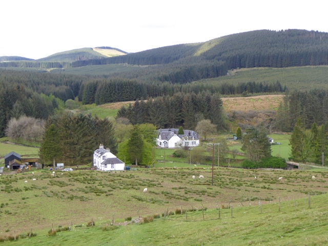
Moodlaw Loch is a picturesque freshwater loch located in Dumfriesshire, Scotland. Nestled amidst the rolling hills and lush greenery, this natural gem offers a tranquil and idyllic setting for visitors to immerse themselves in nature's beauty. Covering an area of approximately 10 acres, Moodlaw Loch boasts a diverse ecosystem that supports a wide range of flora and fauna.

Surrounded by dense woodlands, the loch is home to various species of waterfowl, including swans, ducks, and geese, making it a haven for birdwatchers and nature enthusiasts. The calm waters of the loch provide a perfect habitat for aquatic plants, such as water lilies and reeds, which add to its visual appeal.

The loch is easily accessible via a well-maintained footpath that winds its way around the perimeter. This path offers visitors the opportunity to take leisurely strolls while soaking in the serene atmosphere and stunning views. Many visitors also choose to bring their fishing gear to try their luck at catching some of the loch's abundant fish population, which includes trout and perch.

Moodlaw Loch is not just a destination for leisure activities; it also serves as an important freshwater marsh, providing a habitat for various amphibians and invertebrates. The marshy areas surrounding the loch are teeming with life, with frogs, toads, and dragonflies being commonly spotted.

Overall, Moodlaw Loch offers a peaceful retreat from the hustle and bustle of everyday life. Its scenic beauty, diverse wildlife, and serene ambiance make it a must-visit destination for nature lovers and those seeking a moment of tranquility in Dumfriesshire.

If you have any feedback on the listing, please let us know in the comments section below.

Moodlaw Loch Images

Images are sourced within 2km of 55.355492/-3.1141603 or Grid Reference NT2907. Thanks to Geograph Open Source API. All images are credited.

On the south-east flank of Quickningair Hill Almost pristine snow on a forestry access track on Quickningair Hill - fox and hare tracks were the notable impressions.

This photograph was taken during the Coronavirus (COVID-19) pandemic of 2020.
On the south-east flank of Quickningair Hill
Almost pristine snow on a forestry access track on Quickningair Hill - fox and hare tracks were the notable impressions. This photograph was taken during the Coronavirus (COVID-19) pandemic of 2020.
Sundown in the forest A view over the western extreme of Craik Forest at 1537 hrs on a late December afternoon.

This photograph was taken during the Coronavirus (COVID-19) pandemic of 2020.
Sundown in the forest
A view over the western extreme of Craik Forest at 1537 hrs on a late December afternoon. This photograph was taken during the Coronavirus (COVID-19) pandemic of 2020.
Snow-laden branches Snow-laden branches hang over the forestry access track near Moodlaw Loch.  Light, wind-driven snow had penetrated deep into the spruce stands and formed fluffy deposits on the branches in the area.

This photograph was taken during the Coronavirus (COVID-19) pandemic of 2020.
Snow-laden branches
Snow-laden branches hang over the forestry access track near Moodlaw Loch. Light, wind-driven snow had penetrated deep into the spruce stands and formed fluffy deposits on the branches in the area. This photograph was taken during the Coronavirus (COVID-19) pandemic of 2020.
A snowy scene at Moodlaw Loch With a temperature of -1°C, Moodlaw Loch was partially-frozen.  The forest has recently been harvested, opening up the loch a little to the north-east.  Forestry machinery could be heard operating in the distance.

This photograph was taken during the Coronavirus (COVID-19) pandemic of 2020.
A snowy scene at Moodlaw Loch
With a temperature of -1°C, Moodlaw Loch was partially-frozen. The forest has recently been harvested, opening up the loch a little to the north-east. Forestry machinery could be heard operating in the distance. This photograph was taken during the Coronavirus (COVID-19) pandemic of 2020.
Reflections at Moodlaw Loch Some spindly spruce specimens have been spared from the harvester and stand (perhaps not for long) on the exposed north-eastern side of Moodlaw Loch.

This photograph was taken during the Coronavirus (COVID-19) pandemic of 2020.
Reflections at Moodlaw Loch
Some spindly spruce specimens have been spared from the harvester and stand (perhaps not for long) on the exposed north-eastern side of Moodlaw Loch. This photograph was taken during the Coronavirus (COVID-19) pandemic of 2020.
The southern end of Moodlaw Loch The area in the foreground consists of damp, tussocky vegetation and one has to be wary where the feet are placed.  Harvesting is taking place nearby and it may well be that come the same time next year, Moodlaw Loch is free of forestry on all sides.

This photograph was taken during the Coronavirus (COVID-19) pandemic of 2020.
The southern end of Moodlaw Loch
The area in the foreground consists of damp, tussocky vegetation and one has to be wary where the feet are placed. Harvesting is taking place nearby and it may well be that come the same time next year, Moodlaw Loch is free of forestry on all sides. This photograph was taken during the Coronavirus (COVID-19) pandemic of 2020.
Late afternoon in the forest Sundown approaching in the forest west of Moodlaw Loch.

This photograph was taken during the Coronavirus (COVID-19) pandemic of 2020.
Late afternoon in the forest
Sundown approaching in the forest west of Moodlaw Loch. This photograph was taken during the Coronavirus (COVID-19) pandemic of 2020.
Between Black Sike and Quickening Cleuch Various stages of forestry as viewed from the access track approaching sundown.  The distinctive profile of the Eildon Hills near Melrose could clearly be noted from this vantage point.

This photograph was taken during the Coronavirus (COVID-19) pandemic of 2020.
Between Black Sike and Quickening Cleuch
Various stages of forestry as viewed from the access track approaching sundown. The distinctive profile of the Eildon Hills near Melrose could clearly be noted from this vantage point. This photograph was taken during the Coronavirus (COVID-19) pandemic of 2020.
Quickening Cleuch A view of Quickening Cleuch from the forestry access track nearby.

This photograph was taken during the Coronavirus (COVID-19) pandemic of 2020.
Quickening Cleuch
A view of Quickening Cleuch from the forestry access track nearby. This photograph was taken during the Coronavirus (COVID-19) pandemic of 2020.
Crossing the Wolfcleuch Burn The road has been reopened after being blocked by windthrown trees. Some paths are still blocked elsewhere in the forest.
Crossing the Wolfcleuch Burn
The road has been reopened after being blocked by windthrown trees. Some paths are still blocked elsewhere in the forest.
Ride, Long Tae (Craik Forest) This ride was once enclosed like its continuation over on far side of the Rankle Burn. One side was felled, and the wind did for the remaining trees on the eastern side. Cotton grass is a reminder that this was once boggy moorland.
Ride, Long Tae (Craik Forest)
This ride was once enclosed like its continuation over on far side of the Rankle Burn. One side was felled, and the wind did for the remaining trees on the eastern side. Cotton grass is a reminder that this was once boggy moorland.
Ride junction, Long Tae A large replanted area on the northeast side of a boggy ride (complete with cotton grass).
Ride junction, Long Tae
A large replanted area on the northeast side of a boggy ride (complete with cotton grass).
Road, Post Office Knowe Near the road end on the Dumfriesshire side of Post Office Knowe.
Road, Post Office Knowe
Near the road end on the Dumfriesshire side of Post Office Knowe.
Sitka plantation, Craik Forest Deep in the shade.
Sitka plantation, Craik Forest
Deep in the shade.
Young trees. Long Tae A cleared and replanted part of Craik Forest.
Young trees. Long Tae
A cleared and replanted part of Craik Forest.
Wind thrown forest After the removal of a block neighbouring trees, having lost their shelter, often get blown down. Dangerous and expensive to clear up.
Wind thrown forest
After the removal of a block neighbouring trees, having lost their shelter, often get blown down. Dangerous and expensive to clear up.
End of the road Nearing the edge of the Forestry Commission's part of Craik Forest and the logging road stops. A wet ride heads southwards towards another block of young trees.
End of the road
Nearing the edge of the Forestry Commission's part of Craik Forest and the logging road stops. A wet ride heads southwards towards another block of young trees.
Young trees, Long Tae Replanted block of Sitka spruce, Craik Forest.
Young trees, Long Tae
Replanted block of Sitka spruce, Craik Forest.
Show me another place!

Moodlaw Loch is located at Grid Ref: NT2907 (Lat: 55.355492, Lng: -3.1141603)

Unitary Authority: Dumfries and Galloway

Police Authority: Dumfries and Galloway

What 3 Words

///tens.started.splints. Near Ettrick, Scottish Borders

Nearby Locations

Loch Rig Moodlaw Loch

Related Wikis

Craik, Scottish Borders

Craik is a hamlet in Craik Forest, by the Airhouse Burn in the Scottish Borders area of Scotland, close to Roberton, Scottish Borders (grid reference NT348084...

Craik Forest

Craik Forest is a forest near Hawick in the Scottish Borders area of Scotland, and managed by the Forestry Commission. It is adjoined to the south-west...

Buccleuch, Scottish Borders

East and West Buccleuch ( bə-KLOO) are two homesteads in the Scottish Borders, in the Ettrick parish of historic Selkirkshire. They are located off the...

Eskdalemuir Observatory

The Eskdalemuir Observatory is a UK national environmental observatory located near Eskdalemuir, Dumfries and Galloway, Scotland. Along with Lerwick and...

Ettrick, Scotland

Ettrick (Scottish Gaelic: Eadaraig, IPA: [ˈet̪əɾɪkʲ]) is a small village and civil parish in the Scottish Borders area of Scotland. It is located on the...

Kagyu Samye Ling Monastery and Tibetan Centre

Kagyu Samye Ling Monastery and Tibetan Centre is a Tibetan Buddhist complex associated with the Karma Kagyu school located at Eskdalemuir, Scotland....

Falnash

Falnash (Scots: Fawenesh) is a village in the Scottish Borders of Scotland. It is near Teviothead, in the former Roxburghshire, and in the parish of Teviothead...

Ettrick Pen

Ettrick Pen is a hill in the Ettrick Hills range, part of the Southern Uplands of Scotland. A remote peak, It lies southwest of the village of Ettrick...

Have you been to Moodlaw Loch?

Leave your review of Moodlaw Loch below (or comments, questions and feedback).