Loch of Lintrathen

Lake, Pool, Pond, Freshwater Marsh in Angus

Scotland

Loch of Lintrathen

Sand and mud flats, Loch of Lintrathen The northernmost corner of the loch where low water levels expose areas of sand and mud.
Sand and mud flats, Loch of Lintrathen Credit: Gordon Hatton

Loch of Lintrathen, located in Angus, Scotland, is a picturesque freshwater loch encompassing an area of approximately 560 acres. Nestled amidst rolling hills and surrounded by dense woodlands, the loch offers a serene and tranquil setting for visitors.

The loch is fed by the Lintrathen Burn and various small streams, ensuring a constant flow of freshwater. Its depth reaches up to 21 meters, providing a habitat for a diverse range of aquatic species. Anglers are particularly drawn to the loch, as it is well-stocked with brown trout, rainbow trout, and pike, making it a popular destination for fishing enthusiasts.

The surrounding area is rich in wildlife, with numerous bird species taking refuge in the loch's marshy edges and reed beds. Visitors can spot a variety of waterfowl, including tufted ducks, teal, and wigeons, as well as larger birds such as herons and grebes. The loch is also a designated site of special scientific interest due to its diverse vegetation and important role in supporting local ecosystems.

For those seeking outdoor activities, Loch of Lintrathen offers opportunities for sailing and windsurfing. The tranquil waters and gentle breezes make it an ideal location for water sports enthusiasts of all levels. Additionally, the loch is surrounded by a network of walking trails, allowing visitors to explore the scenic beauty of the area on foot.

Overall, Loch of Lintrathen is a haven of natural beauty and biodiversity. With its diverse wildlife, recreational activities, and stunning surroundings, it offers a memorable experience for visitors seeking to immerse themselves in the tranquility of Angus' countryside.

If you have any feedback on the listing, please let us know in the comments section below.

Loch of Lintrathen Images

Images are sourced within 2km of 56.680242/-3.1828318 or Grid Reference NO2754. Thanks to Geograph Open Source API. All images are credited.
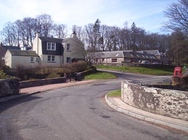
Sand and mud flats, Loch of Lintrathen The northernmost corner of the loch where low water levels expose areas of sand and mud.
Sand and mud flats, Loch of Lintrathen
The northernmost corner of the loch where low water levels expose areas of sand and mud.
Melgam Water enters the Loch of Lintrathen The OS maps shows much of this area in blue, but with water levels low in the loch there is much sand and mud exposed which has become green with vegetation.
Melgam Water enters the Loch of Lintrathen
The OS maps shows much of this area in blue, but with water levels low in the loch there is much sand and mud exposed which has become green with vegetation.
Telephone box at Bridgend of Lintrathen The few buildings at the village of Bridgend of Lintrathen lie immediately below the dam of the Loch of Lintrathen; it's hidden from view in the image by trees. The telephone box is still standing, if leaning; it's not known if there's a functioning telephone inside.
Until recently, close beside the box stood an old, protected road sign; it was demolished by a falling tree during one of the storms of winter 2021-2022. A photograph of it can be seen... <a title="https://www.geograph.org.uk/photo/6043246" href="https://www.geograph.org.uk/photo/6043246">Link</a> .
Telephone box at Bridgend of Lintrathen
The few buildings at the village of Bridgend of Lintrathen lie immediately below the dam of the Loch of Lintrathen; it's hidden from view in the image by trees. The telephone box is still standing, if leaning; it's not known if there's a functioning telephone inside. Until recently, close beside the box stood an old, protected road sign; it was demolished by a falling tree during one of the storms of winter 2021-2022. A photograph of it can be seen... Link .
Loch of Lintrathen It is always surprisingly difficult to access the shore of Loch of Lintrathen. This stretch here is accessed by parking on a small space on the west side, and then ambling through a hole in the hedge down a narrow path to the shore.
Loch of Lintrathen
It is always surprisingly difficult to access the shore of Loch of Lintrathen. This stretch here is accessed by parking on a small space on the west side, and then ambling through a hole in the hedge down a narrow path to the shore.
Field above Loch of Lintrathen A mapped clump of trees.
Field above Loch of Lintrathen
A mapped clump of trees.
Pitmudie View upstream, along the Melgam Water.
Pitmudie
View upstream, along the Melgam Water.
Woodland, Pitmudie
Woodland, Pitmudie
Pitmudie Fields amongst the woodlands near Loch of Lintrathen.
Pitmudie
Fields amongst the woodlands near Loch of Lintrathen.
B951 A bridge over the Inzion Burn.
B951
A bridge over the Inzion Burn.
North of Loch of Lintrathen Cattle were grazing a set of fields with the interconnecting gates left open.  The woodlands are by the Inzeon Burn.
North of Loch of Lintrathen
Cattle were grazing a set of fields with the interconnecting gates left open. The woodlands are by the Inzeon Burn.
North of Loch of Lintrathen Cattle were grazing these fields.
North of Loch of Lintrathen
Cattle were grazing these fields.
North of Loch of Lintrathen Fields at the foot of Brankam Hill.
North of Loch of Lintrathen
Fields at the foot of Brankam Hill.
Loch of Lintrathen The loch is well screened by trees, here there is a glimpse from above the B951.
Loch of Lintrathen
The loch is well screened by trees, here there is a glimpse from above the B951.
Barley beneath Brankam Hill
Gravel pit Sandy deposits have been quarried near Loch of Lintrathen.
Gravel pit
Sandy deposits have been quarried near Loch of Lintrathen.
Isla Primary School At Lintrathen.
<span class="nowrap"><a title="http://www.angus.gov.uk/directory_record/461/isla_primary_school" rel="nofollow ugc noopener" href="http://www.angus.gov.uk/directory_record/461/isla_primary_school">Link</a><img style="margin-left:2px;" alt="External link" title="External link - shift click to open in new window" src="https://s1.geograph.org.uk/img/external.png" width="10" height="10"/></span>
Isla Primary School
At Lintrathen. LinkExternal link
Arable field on Gallow Knowe Loch of Lintrathen reservoir in the background.
Arable field on Gallow Knowe
Loch of Lintrathen reservoir in the background.
Crossroads near Loch of Lintrathen B951 junction, right for Balintore and left for Formal via the west shore of the loch - a reservoir of potable water for Dundee. [Lintrathen ~ High water/fast-flowing water]
Crossroads near Loch of Lintrathen
B951 junction, right for Balintore and left for Formal via the west shore of the loch - a reservoir of potable water for Dundee. [Lintrathen ~ High water/fast-flowing water]
Show me another place!

Loch of Lintrathen is located at Grid Ref: NO2754 (Lat: 56.680242, Lng: -3.1828318)

Unitary Authority: Angus

Police Authority: Tayside

What 3 Words

///starring.immune.clinking. Near Alyth, Perth & Kinross

Related Wikis

Loch of Lintrathen

Loch of Lintrathen is a man-made loch occupying a glacial basin at the southern end of Glen Isla, approximately 13 kilometres (8.1 mi) west of town of...

Bridgend of Lintrathen

Bridgend of Lintrathen is a village in Angus, Scotland. It is situated on the southern shore of Loch of Lintrathen, six miles west of Kirriemuir. ��2...

Bridge of Craigisla

Bridge of Craigisla is a hamlet in Angus, Scotland. The bridge crosses the River Isla. This settlement lies along the B954 road. == References ==

Airlie Castle

Airlie Castle is a mansion house in the parish of Airlie, Angus, near the junction of the Isla and Melgund rivers, 9 kilometres west of Kirriemuir, Angus...

Nearby Amenities

Located within 500m of 56.680242,-3.1828318
Kinloch Cottage
Place: isolated_dwelling
Lat/Long: 56.684375/-3.184642
Power: pole
Lat/Long: 56.6845399/-3.1846589
The data included in this document is from www.openstreetmap.org. The data is made available under ODbL.

Have you been to Loch of Lintrathen?

Leave your review of Loch of Lintrathen below (or comments, questions and feedback).