Greendale Tarn

Lake, Pool, Pond, Freshwater Marsh in Cumberland Copeland

England

Greendale Tarn

Flush Bracket benchmark, Seatallan Detail of the flush bracket benchmark on the triangulation pillar on the summit of Seatallan. The flush bracket, benchmark number S5762, is on the south south east face of the pillar and marks a height of 692.200m above sea level (Ordnance Datum Newlyn), last levelled in 1952 (location photograph <a href="https://www.geograph.org.uk/photo/7080016">NY1308 : Triangulation pillar, Seatallan</a>).
Flush Bracket benchmark, Seatallan Credit: Adrian Taylor

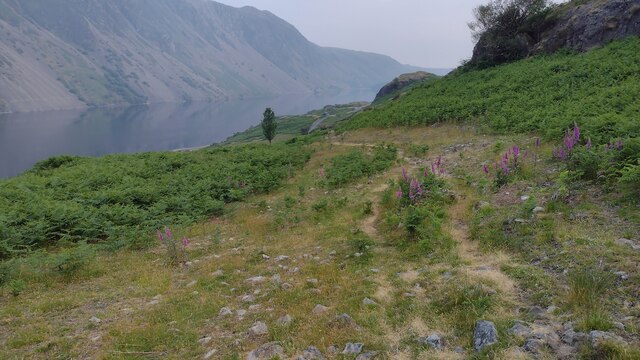
Greendale Tarn is a picturesque freshwater lake located in the county of Cumberland, England. Nestled amidst the tranquil landscape of the Lake District National Park, this natural wonder has captivated visitors for centuries with its serene beauty and diverse ecosystem.

Spanning an area of approximately 10 acres, Greendale Tarn boasts crystal-clear waters that reflect the surrounding fells and lush vegetation. The lake is fed by several small streams that meander through the nearby valleys, ensuring a constant supply of fresh water. Its depth varies, with the deepest parts reaching around 20 feet, providing a haven for a variety of aquatic life.

Surrounded by verdant meadows and pristine woodlands, Greendale Tarn offers a habitat for numerous species of flora and fauna. The lake's shores are adorned with vibrant wildflowers, creating a colorful tapestry that changes with the seasons. The area is particularly renowned for its diverse bird population, attracting ornithologists and birdwatchers alike. Species such as herons, ducks, and swans can often be spotted gracefully gliding across the water's surface.

The lake also features a small freshwater marsh, which provides an ideal breeding ground for amphibians and a habitat for various marshland plants. This marshland is a crucial part of the lake's ecosystem, acting as a natural filter that helps to maintain the water's clarity and purity.

Greendale Tarn is a haven for nature enthusiasts, offering opportunities for fishing, birdwatching, and scenic walks along its tranquil shores. Its idyllic setting and rich biodiversity make it a beloved destination for locals and tourists seeking solace in the natural beauty of Cumberland's landscape.

If you have any feedback on the listing, please let us know in the comments section below.

Greendale Tarn Images

Images are sourced within 2km of 54.455458/-3.3167853 or Grid Reference NY1407. Thanks to Geograph Open Source API. All images are credited.

Flush Bracket benchmark, Seatallan Detail of the flush bracket benchmark on the triangulation pillar on the summit of Seatallan. The flush bracket, benchmark number S5762, is on the south south east face of the pillar and marks a height of 692.200m above sea level (Ordnance Datum Newlyn), last levelled in 1952 (location photograph <a href="https://www.geograph.org.uk/photo/7080016">NY1308 : Triangulation pillar, Seatallan</a>).
Flush Bracket benchmark, Seatallan
Detail of the flush bracket benchmark on the triangulation pillar on the summit of Seatallan. The flush bracket, benchmark number S5762, is on the south south east face of the pillar and marks a height of 692.200m above sea level (Ordnance Datum Newlyn), last levelled in 1952 (location photograph NY1308 : Triangulation pillar, Seatallan).
Triangulation pillar, Seatallan The triangulation pillar on the summit of Seatallan.
The flush bracket benchmark number S5762 on the south south east face of the pillar marks a height of 692.200m above sea level (Ordnance Datum Newlyn) last levelled in 1952 (photograph <a href="https://www.geograph.org.uk/photo/7079993">NY1308 : Flush Bracket benchmark, Seatallan</a>).
Triangulation pillar, Seatallan
The triangulation pillar on the summit of Seatallan. The flush bracket benchmark number S5762 on the south south east face of the pillar marks a height of 692.200m above sea level (Ordnance Datum Newlyn) last levelled in 1952 (photograph NY1308 : Flush Bracket benchmark, Seatallan).
Greendale Tarn Below Middle Fell looking to Greendale Tarn
Greendale Tarn
Below Middle Fell looking to Greendale Tarn
Bridleway heading down by Nether Beck Bridleway heading down by Nether Beck with Middle Fell in the distance
Bridleway heading down by Nether Beck
Bridleway heading down by Nether Beck with Middle Fell in the distance
Bridleway heading down by Nether Beck Bridleway heading down by Nether Beck near Standy Gill
Bridleway heading down by Nether Beck
Bridleway heading down by Nether Beck near Standy Gill
Bridleway from Nether Beck Bridleway from Nether Beck coming out on the road by Wast Water
Bridleway from Nether Beck
Bridleway from Nether Beck coming out on the road by Wast Water
Wall, Greendale Backed with the impressive Buckbarrow which looks like a smaller version of Pike o Stickle
Wall, Greendale
Backed with the impressive Buckbarrow which looks like a smaller version of Pike o Stickle
Violet The fells are studded with violets at this time of year
Violet
The fells are studded with violets at this time of year
Greendale Gill Gorse coming into flower by the gill
Greendale Gill
Gorse coming into flower by the gill
Old Fold By Tongues Gills on the steep west bank of Greendale Gill
Old Fold
By Tongues Gills on the steep west bank of Greendale Gill
On Buckbarrow On Broad Crag, Buckbarrow. Looking towards The Scafells
On Buckbarrow
On Broad Crag, Buckbarrow. Looking towards The Scafells
On Buckbarrow Looking towards Middle Fell
On Buckbarrow
Looking towards Middle Fell
On Seatallen On the extensive southern slope. There are several rudimentary bields in the sprinkling of boulders on the flank.
On Seatallen
On the extensive southern slope. There are several rudimentary bields in the sprinkling of boulders on the flank.
On Seatallan Mickledore on Scafell Pike in shot beyond Middle Fell from the grassy southern flank of Seatallan.
On Seatallan
Mickledore on Scafell Pike in shot beyond Middle Fell from the grassy southern flank of Seatallan.
On Middle Fell Looking towards the Scafells.
On Middle Fell
Looking towards the Scafells.
On Middle Fell Looking towards Buckbarrow
On Middle Fell
Looking towards Buckbarrow
Descending Middle Fell Heading for Greendale which is aptly named with emerald green fields at the foot of the fell.
Descending Middle Fell
Heading for Greendale which is aptly named with emerald green fields at the foot of the fell.
Netherbeck Bridge, Wasdale This carries the road to Wasdale Head over Nether Beck.
Netherbeck Bridge, Wasdale
This carries the road to Wasdale Head over Nether Beck.
Show me another place!

Greendale Tarn is located at Grid Ref: NY1407 (Lat: 54.455458, Lng: -3.3167853)

Administrative County: Cumbria

District: Copeland

Police Authority: Cumbria

What 3 Words

///sunbeam.pins.shop. Near Seascale, Cumbria

Nearby Locations

Greendale Tarn

Related Wikis

Middle Fell

Middle Fell is a hill or fell in the English Lake District. It is a satellite of Seatallan standing above the northern shore of Wastwater. Middle Fell...

Seatallan

Seatallan is a mountain in the western part of the English Lake District. It is rounded, grassy and fairly unassuming, occupying a large amount of land...

Buckbarrow

Buckbarrow is a small fell in the English Lake District overlooking the western end of Wastwater. It is featured in Alfred Wainwright’s Pictorial Guide...

Wast Water

Wast Water or Wastwater () is a lake located in Wasdale, a valley in the western part of the Lake District National Park, England. The lake is almost three...

Nearby Amenities

Located within 500m of 54.455458,-3.3167853
Middle Fell
Ele: 582
Natural: peak
Source: npe
Wikidata: Q8524368
Wikipedia: en:Middle Fell
Lat/Long: 54.4531982/-3.3113946
The data included in this document is from www.openstreetmap.org. The data is made available under ODbL.

Have you been to Greendale Tarn?

Leave your review of Greendale Tarn below (or comments, questions and feedback).