Allt na h-Eirghe

Lake, Pool, Pond, Freshwater Marsh in Inverness-shire

Scotland

Allt na h-Eirghe

Heather moorland, Braes of Abernethy Moorland with some scattered clumps of pine trees.
Heather moorland, Braes of Abernethy Credit: Alan O'Dowd

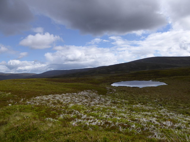
Allt na h-Eirghe is a small freshwater marsh located in Inverness-shire, Scotland. It is situated near the village of Invermoriston, close to the eastern shore of Loch Ness. The name "Allt na h-Eirghe" translates to "stream of the shieling" in Gaelic, reflecting the historical use of the area for seasonal farming.

The marsh is characterized by its diverse aquatic vegetation and rich wildlife. It comprises a combination of open water, reed beds, and wetland vegetation, creating a variety of habitats for different species. The open water areas are often home to waterfowl, such as ducks and geese, while the reed beds provide nesting sites for birds like reed warblers and sedge warblers.

The vegetation surrounding Allt na h-Eirghe consists of a mix of grasses, sedges, and rushes, which thrive in the marshy conditions. This vegetation not only provides food and shelter for various insects and invertebrates but also acts as a natural filter, helping to improve water quality in the surrounding area.

The marsh is also known for its important role in water regulation and flood prevention. During periods of heavy rainfall, the wetland acts as a sponge, absorbing excess water and reducing the risk of flooding downstream.

Allt na h-Eirghe is a popular destination for nature enthusiasts and birdwatchers, who can enjoy the tranquil surroundings while observing the diverse range of wildlife. It is important to note that access to the marsh may be restricted during certain times of the year to protect nesting birds and other sensitive wildlife.

If you have any feedback on the listing, please let us know in the comments section below.

Allt na h-Eirghe Images

Images are sourced within 2km of 57.217777/-3.5021312 or Grid Reference NJ0915. Thanks to Geograph Open Source API. All images are credited.

Heather moorland, Braes of Abernethy Moorland with some scattered clumps of pine trees.
Heather moorland, Braes of Abernethy
Moorland with some scattered clumps of pine trees.
Moorland, Bac na Craoibhe Looking across Allt Slugan na Cloiche below Geal Charn towards the distant Foregin Hills north of Carrbridge.
Moorland, Bac na Craoibhe
Looking across Allt Slugan na Cloiche below Geal Charn towards the distant Foregin Hills north of Carrbridge.
Allt na h-Eirghe at the Braes of Abernethy
Ruined house at Upper Dell Deserted apart from lapwings and curlews, and surrounded by a healthy patch of nettles, as is often the case where there was once human habitation.
Ruined house at Upper Dell
Deserted apart from lapwings and curlews, and surrounded by a healthy patch of nettles, as is often the case where there was once human habitation.
Abandoned farm, Upper Dell Deserted apart from curlews, and lapwings wheeling around noisily.
Abandoned farm, Upper Dell
Deserted apart from curlews, and lapwings wheeling around noisily.
Loch an Sidhein Dhuibh ('loch of the black fairy') This kettle hole must be one of the smallest bodies of water to be named a loch, rather than a lochan.
Loch an Sidhein Dhuibh ('loch of the black fairy')
This kettle hole must be one of the smallest bodies of water to be named a loch, rather than a lochan.
Ford on Allt na h-Eìrghe ('burn of the uprising') Perhaps a Jacobite-related placename - the site of the Battle of Cromdale in 1690 is a few miles away.
Ford on Allt na h-Eìrghe ('burn of the uprising')
Perhaps a Jacobite-related placename - the site of the Battle of Cromdale in 1690 is a few miles away.
Estate Track, Dorback A track across moorland in the Braes of Abernethy, approaching Allt na h-Eìrghe ('burn of the uprising').
Estate Track, Dorback
A track across moorland in the Braes of Abernethy, approaching Allt na h-Eìrghe ('burn of the uprising').
North-west spur of Geal Charn A relatively gentle heathery slope on Geal Charn, on dry ground above Allt nan Gamhuinn ('burn of the stirk').
North-west spur of Geal Charn
A relatively gentle heathery slope on Geal Charn, on dry ground above Allt nan Gamhuinn ('burn of the stirk').
A Grouse Butt on Tom na Fianaig (Hill), Speyside
View over the Valley of the Dorback Burn, Cairngorms View from the west side of Carn na Farraidh over the valley of the Dorback Burn (watercourse) in the Cairngorm Mountains National Park in Scotland.  Near the Braes of Abernethy and Upper Dell.
View over the Valley of the Dorback Burn, Cairngorms
View from the west side of Carn na Farraidh over the valley of the Dorback Burn (watercourse) in the Cairngorm Mountains National Park in Scotland. Near the Braes of Abernethy and Upper Dell.
Burn of Dorback (Watercourse), Cairngorms National Park A typical upland stream with sediment deposits from a spate.
Burn of Dorback (Watercourse), Cairngorms National Park
A typical upland stream with sediment deposits from a spate.
End of the stalkers' track
Lunch house on the moor
Path descending Gael Charn
Descending north from Gael Charn
A side track to the butts
Allt Nan Gamhuinn
Allt Nan Gamhuinn
Show me another place!

Allt na h-Eirghe is located at Grid Ref: NJ0915 (Lat: 57.217777, Lng: -3.5021312)

Unitary Authority: Highland

Police Authority: Highlands and Islands

What 3 Words

///unrealistic.purified.chained. Near Grantown-on-Spey, Highland

Nearby Locations

Allt na h-Eirghe

Related Wikis

A939 road

The A939 'Lecht Road' connects the A96 at Nairn on the Moray Coast with the A95 Grantown on Spey, then it continues to the A93 at Ballater by way of the...

Lynbreck Croft

Lynbreck Croft is a 59 hectares (150 acres) farm near Tomintoul in the Highlands of Scotland. The land is held under crofting tenure and the activities...

Tomintoul

Tomintoul ( ; from Scottish Gaelic: Tom an t-Sabhail, meaning "Hillock of the Barn") is a village in the Moray council area of Scotland in the historic...

Abernethy Forest

Abernethy Forest is a remnant of the Caledonian Forest in Strathspey, in the Highland council area of Scotland. It lies within the Cairngorms National...

Nearby Amenities

Located within 500m of 57.217777,-3.5021312
Ford: yes
Lat/Long: 57.2190071/-3.5000109
The data included in this document is from www.openstreetmap.org. The data is made available under ODbL.

Have you been to Allt na h-Eirghe?

Leave your review of Allt na h-Eirghe below (or comments, questions and feedback).