Nant Colwyn

Lake, Pool, Pond, Freshwater Marsh in Montgomeryshire

Wales

Nant Colwyn
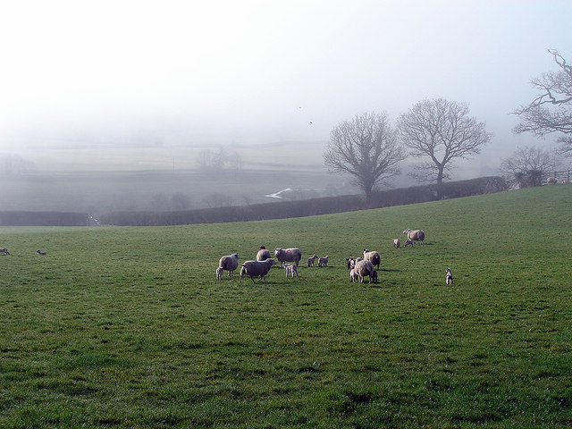
Sheep at Pen-y-ffynnon Viewed from a footpath just leaving Park Wood. Afon Trannon is just visible in the valley below.
Sheep at Pen-y-ffynnon Credit: John Lucas

The requested URL returned error: 429 Too Many Requests

If you have any feedback on the listing, please let us know in the comments section below.

Nant Colwyn Images

Images are sourced within 2km of 52.521068/-3.4942241 or Grid Reference SN9892. Thanks to Geograph Open Source API. All images are credited.

Sheep at Pen-y-ffynnon Viewed from a footpath just leaving Park Wood. Afon Trannon is just visible in the valley below.
Sheep at Pen-y-ffynnon
Viewed from a footpath just leaving Park Wood. Afon Trannon is just visible in the valley below.
Tree in the hedgerow Near Pen-y-ffynon. The sun is just breaking through after a very misty start to the day.
Tree in the hedgerow
Near Pen-y-ffynon. The sun is just breaking through after a very misty start to the day.
Approaching Pen-y-ffynnon [farm] On a minor no-through-road from Ddaenen Ddu.
Approaching Pen-y-ffynnon [farm]
On a minor no-through-road from Ddaenen Ddu.
Farmland at Lower Ffrydd Park Wood stands on the hillside above.
Farmland at Lower Ffrydd
Park Wood stands on the hillside above.
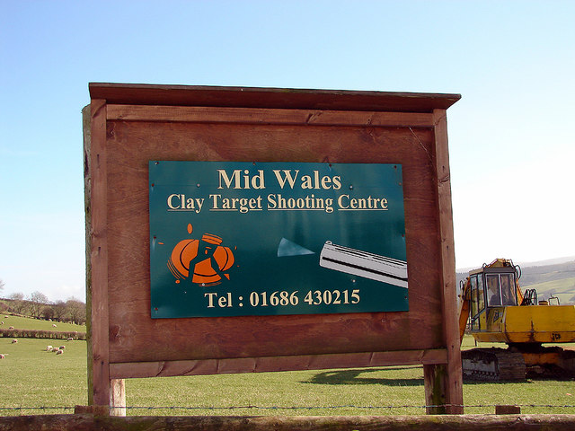
Mid-Wales Clay Target Shooting Centre Beside the B4569 road near Trefeglwys.
Mid-Wales Clay Target Shooting Centre
Beside the B4569 road near Trefeglwys.
Upper Ffrydd and Lower Ffrydd Another interesting mix of English and Welsh. Where I live, in Ceredigion, that would be Ffrydd-uchaf and Ffrydd-isaf or maybe Ffridd-uchaf and Ffridd-isaf. Indeed, the OS is also somewhat confused as Ffridd-uchaf is marked as such but its neighbour is shown as Lower Ffrydd!
Upper Ffrydd and Lower Ffrydd
Another interesting mix of English and Welsh. Where I live, in Ceredigion, that would be Ffrydd-uchaf and Ffrydd-isaf or maybe Ffridd-uchaf and Ffridd-isaf. Indeed, the OS is also somewhat confused as Ffridd-uchaf is marked as such but its neighbour is shown as Lower Ffrydd!
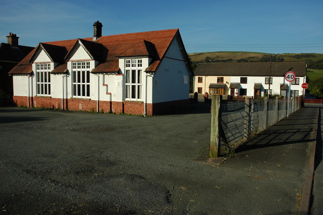
Entering Trefeglwys With Gleiniant Calvinistic Methodist Chapel and its associated British School prominent in the view.
Entering Trefeglwys
With Gleiniant Calvinistic Methodist Chapel and its associated British School prominent in the view.
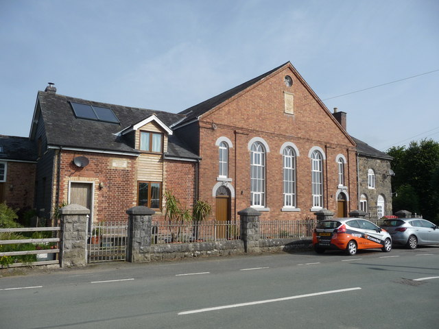
Gleiniant Chapel and British School The school is the annex at this end of the building. The chapel dates from 1823 (rebuilt 1870) and the school from 1865.
Gleiniant Chapel and British School
The school is the annex at this end of the building. The chapel dates from 1823 (rebuilt 1870) and the school from 1865.
Converted chapel
Converted chapel
Bodaioch Hall Large house on the outskirts of Trefeqlwys.
Bodaioch Hall
Large house on the outskirts of Trefeqlwys.
House above the Trannon valley
Cefn Farm, near Trefeglwys Foel y Belan <a href="https://www.geograph.org.uk/gridref/SN9993">SN9993</a> rises beyond.
Cefn Farm, near Trefeglwys
Foel y Belan SN9993 rises beyond.
Country lane near Fridd-uchaf Running down to join the B4569 Trefeglwys to Caersws road.
Country lane near Fridd-uchaf
Running down to join the B4569 Trefeglwys to Caersws road.
Old chapel and school at Gleiniant near Trefeglwys Now apparently converted into a home or homes.
Old chapel and school at Gleiniant near Trefeglwys
Now apparently converted into a home or homes.
Mid Wales Clay Target Shooting Centre The entrance is marked with flags of a curious selection of nations. I could hear shooting and, checking the website <span class="nowrap"><a title="http://www.midwalesshootingcentre.com/" rel="nofollow ugc noopener" href="http://www.midwalesshootingcentre.com/">Link</a><img style="margin-left:2px;" alt="External link" title="External link - shift click to open in new window" src="https://s1.geograph.org.uk/img/external.png" width="10" height="10"/></span> , note the BASC 4.10 championships were being held.
Mid Wales Clay Target Shooting Centre
The entrance is marked with flags of a curious selection of nations. I could hear shooting and, checking the website LinkExternal link , note the BASC 4.10 championships were being held.
Mid Wales Clay Target Shooting Centre The entrance is marked with flags of a curious selection of nations. I could hear shooting and, checking the website <span class="nowrap"><a title="http://www.midwalesshootingcentre.com/" rel="nofollow ugc noopener" href="http://www.midwalesshootingcentre.com/">Link</a><img style="margin-left:2px;" alt="External link" title="External link - shift click to open in new window" src="https://s1.geograph.org.uk/img/external.png" width="10" height="10"/></span> , note the BASC 4.10 championships were being held.
The entrance is opposite Ffinnant farm just outside Trefeglwys on the B4569.
Mid Wales Clay Target Shooting Centre
The entrance is marked with flags of a curious selection of nations. I could hear shooting and, checking the website LinkExternal link , note the BASC 4.10 championships were being held. The entrance is opposite Ffinnant farm just outside Trefeglwys on the B4569.
Sheep opposite Ffinnant farm Beside the entrance to Mid Wales Clay Target Shooting Centre. I could hear shooting and, checking the website <span class="nowrap"><a title="http://www.midwalesshootingcentre.com/" rel="nofollow ugc noopener" href="http://www.midwalesshootingcentre.com/">Link</a><img style="margin-left:2px;" alt="External link" title="External link - shift click to open in new window" src="https://s1.geograph.org.uk/img/external.png" width="10" height="10"/></span> , note the BASC 4.10 championships were being held. This didn't seem to bother the sheep.
The low green structures and small shelters in the next field must be something to do with clay shooting.
Sheep opposite Ffinnant farm
Beside the entrance to Mid Wales Clay Target Shooting Centre. I could hear shooting and, checking the website LinkExternal link , note the BASC 4.10 championships were being held. This didn't seem to bother the sheep. The low green structures and small shelters in the next field must be something to do with clay shooting.
Show me another place!

Nant Colwyn is located at Grid Ref: SN9892 (Lat: 52.521068, Lng: -3.4942241)

Unitary Authority: Powys

Police Authority: Dyfed Powys

What 3 Words

///stocks.disgraced.luck. Near Llanidloes, Powys

Nearby Locations

Nant Colwyn

Related Wikis

Pontdolgoch railway station

Pontdolgoch railway station was a station in Pontdolgoch, Powys, Wales. The station opened on 3 January 1863 and closed on 14 June 1965. == References... ==

Pontdolgoch

Pontdolgoch is a very small village in Powys, Wales. It is located on the A470 road, some 2 miles (3.2 km) northwest of Caersws. The River Carno flows...

Clatter, Powys

Clatter is a small village in Powys, Wales located in the community of Caersws on the main A470 road between Carno and Caersws village. == External... ==

Trefeglwys

Trefeglwys is a village and community in Powys, Wales, within the historic county of Montgomeryshire. The name derives from the Welsh language tref 'township...

Nearby Amenities

Located within 500m of 52.521068,-3.4942241
Place: farm
Lat/Long: 52.5201268/-3.4962615
Place: farm
Lat/Long: 52.5217793/-3.4876207
Direction: 195
Generator Method: photovoltaic
Generator Output Electricity: yes
Generator Solar Modules: 10
Generator Source: solar
Generator Type: solar_photovoltaic_panel
Location: roof
Power: generator
Lat/Long: 52.5235522/-3.4988045
The data included in this document is from www.openstreetmap.org. The data is made available under ODbL.

Have you been to Nant Colwyn?

Leave your review of Nant Colwyn below (or comments, questions and feedback).