Bengairn Loch

Lake, Pool, Pond, Freshwater Marsh in Kirkcudbrightshire

Scotland

Bengairn Loch

Track to Bluehill Leaving Blackford Bridge.
Track to Bluehill Credit: Jon Alexander

Bengairn Loch, located in Kirkcudbrightshire, Scotland, is a picturesque freshwater loch surrounded by rolling hills and lush greenery. With a surface area of approximately 20 hectares, it serves as a tranquil oasis for both locals and tourists alike. The loch is situated in the southern part of the country, near the town of Dalbeattie.

With its calm, clear waters, Bengairn Loch provides a perfect habitat for various aquatic species. It is home to a diverse range of both plant and animal life, including numerous species of fish, birds, and invertebrates. Anglers are often drawn to the loch due to its abundance of fish such as brown trout and perch.

The surrounding area of Bengairn Loch is characterized by its wetland and marsh features. Freshwater marshes are found along the shoreline, providing a vital habitat for numerous plant species such as reeds, rushes, and water lilies. These marshes also attract a variety of bird species, including swans, ducks, and herons.

Visitors to Bengairn Loch can enjoy various recreational activities. Fishing is a popular pastime, with many anglers casting their lines from the peaceful banks. Additionally, the loch offers a tranquil setting for boating and kayaking enthusiasts. The scenic trails surrounding the loch are perfect for nature walks and birdwatching, allowing visitors to immerse themselves in the stunning natural beauty of the area.

Overall, Bengairn Loch in Kirkcudbrightshire is a serene freshwater haven teeming with diverse wildlife and providing an idyllic setting for outdoor activities and nature appreciation.

If you have any feedback on the listing, please let us know in the comments section below.

Bengairn Loch Images

Images are sourced within 2km of 54.849748/-3.8885499 or Grid Reference NX7852. Thanks to Geograph Open Source API. All images are credited.

Track to Bluehill Leaving Blackford Bridge.
Track to Bluehill
Leaving Blackford Bridge.
Blackford Bridge The remaining visible parapet of Blackford Bridge crossing Blackford Burn on the old A711, left when it was straightened.
Blackford Bridge
The remaining visible parapet of Blackford Bridge crossing Blackford Burn on the old A711, left when it was straightened.
Auchencairn Parish Church
Church Road, Auchencairn
Farmland at Auchencairn With view over to Torr Point.
Farmland at Auchencairn
With view over to Torr Point.
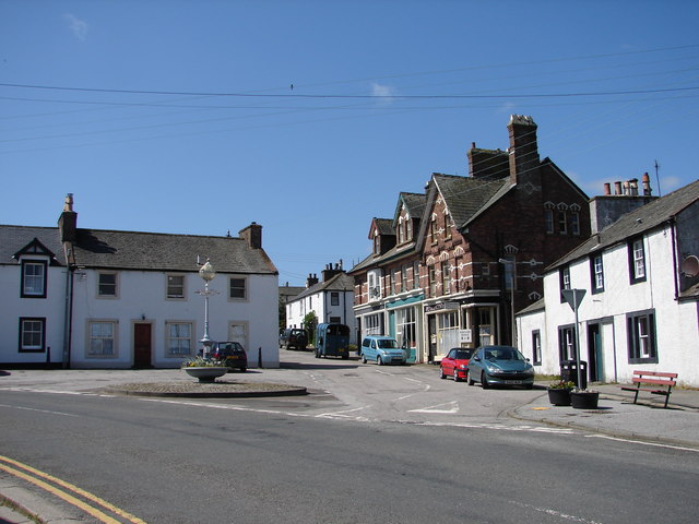
In the centre of Auchencairn The "Jubilee Lamp" was erected by public subscription in 1897 to mark the sixtieth year of Queen Victoria's long reign.
In the centre of Auchencairn
The "Jubilee Lamp" was erected by public subscription in 1897 to mark the sixtieth year of Queen Victoria's long reign.
Looking north-east from the viewpoint at Hazlefield The house on the right is Drungans. The A711 can just be seen curving round to the left.
Looking north-east from the viewpoint at Hazlefield
The house on the right is Drungans. The A711 can just be seen curving round to the left.
Junction of A711 and Shore Road, Auchencairn The bridge on the left carries the A711 across the Auchencairn Burn, which enters Auchencairn Bay less than half a mile from this point. This is the section of the A711 from Dalbeattie to Kirkcudbright.
The War Memorial on the right is a simple stone Maltese Cross located at the corner of the A711 and Shore Road, a 'no-through road' branching off to the right.
Junction of A711 and Shore Road, Auchencairn
The bridge on the left carries the A711 across the Auchencairn Burn, which enters Auchencairn Bay less than half a mile from this point. This is the section of the A711 from Dalbeattie to Kirkcudbright. The War Memorial on the right is a simple stone Maltese Cross located at the corner of the A711 and Shore Road, a 'no-through road' branching off to the right.
Rascarrel Lane The hill ahead is Bengairn.
Rascarrel Lane
The hill ahead is Bengairn.
Minor country road This single track road serves several isolated farms.
Minor country road
This single track road serves several isolated farms.
Farmland West of Auchencairn Open fields near to Auchencairn.
Farmland West of Auchencairn
Open fields near to Auchencairn.
Cattle at rest Grazing land above Auchencairn.
Cattle at rest
Grazing land above Auchencairn.
Grazing above Auchencairn Grazing land by the road above Auchencairn.
Grazing above Auchencairn
Grazing land by the road above Auchencairn.
Heading west from Auchencairn The minor road leaving Auchencairn.
Heading west from Auchencairn
The minor road leaving Auchencairn.
Auchencairn Cemetery The cemetery on the outskirts of Auchencairn.
Auchencairn Cemetery
The cemetery on the outskirts of Auchencairn.
Show me another place!

Bengairn Loch is located at Grid Ref: NX7852 (Lat: 54.849748, Lng: -3.8885499)

Unitary Authority: Dumfries and Galloway

Police Authority: Dumfries and Galloway

What 3 Words

///districts.knocking.rather. Near Dalbeattie, Dumfries & Galloway

Nearby Locations

Bengairn Loch Forest Wood

Related Wikis

Auchencairn

Auchencairn ([ɔxən'kʰɛ:(r)n]) is a village in the historical county of Kirkcudbrightshire in the Dumfries and Galloway region of Scotland. It is located...

Orchardton Castle

Orchardton Castle overlooks the Solway Coast. Built in the 1880s, this is a Grade B listed property formerly known as Orchardton House. Built around a...

Urr Water

Urr Water or River Urr (arc. River Orr) is a river in which flows through the counties of Dumfriesshire and Kirkcudbrightshire in southwest Scotland....

Wickerman Festival

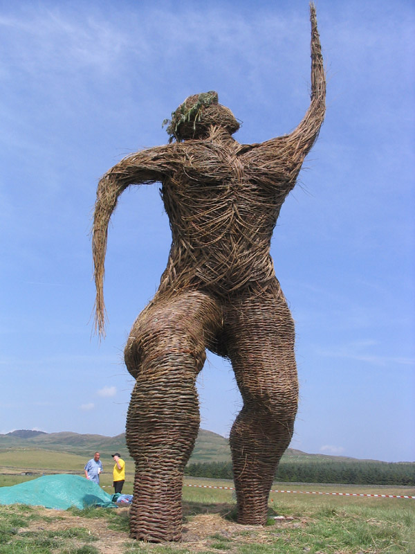
The Wickerman Festival was an annual music festival held near Auchencairn in Dumfries and Galloway, Scotland. Dubbed "Scotland's Alternative Music festival...

Nearby Amenities

Located within 500m of 54.849748,-3.8885499
Power: pole
Lat/Long: 54.8457185/-3.8856099
Power: pole
Lat/Long: 54.8461589/-3.8847113
Power: pole
Lat/Long: 54.8467558/-3.883426
Power: pole
Lat/Long: 54.8473613/-3.8821513
Power: pole
Lat/Long: 54.8525056/-3.8907193
Power: pole
Lat/Long: 54.852283/-3.8917772
Power: pole
Lat/Long: 54.852069/-3.8928374
Power: pole
Lat/Long: 54.851795/-3.8941991
Power: pole
Lat/Long: 54.8514978/-3.8955907
Power: pole
Lat/Long: 54.8465179/-3.8855887
Power: pole
Lat/Long: 54.8471772/-3.8868931
Power: pole
Lat/Long: 54.8479441/-3.8884588
Power: pole
Lat/Long: 54.8485251/-3.8896018
Power: pole
Lat/Long: 54.8493556/-3.8912822
Power: pole
Lat/Long: 54.8502069/-3.8929924
Power: pole
Lat/Long: 54.8508527/-3.8942937
The data included in this document is from www.openstreetmap.org. The data is made available under ODbL.

Have you been to Bengairn Loch?

Leave your review of Bengairn Loch below (or comments, questions and feedback).