Faughlin Reservoir

Lake, Pool, Pond, Freshwater Marsh in Stirlingshire

Scotland

Faughlin Reservoir

Old fingerpost A photo taken in poor light showing the unique fingerpost at the crossroads just north of Carron Bridge which is the southernmost boundary of Stirlingshire with North Lanarkshire and Falkirk.  The only other recorded post of this style was, in 1983, at the junction of the A836 and B838 north of Lairg.  Now lost.
Old fingerpost Credit: John Riddell

Faughlin Reservoir is a picturesque freshwater lake located in Stirlingshire, Scotland. Covering an area of approximately 10 acres, it serves as an important water source for the surrounding region. The reservoir is situated in a tranquil setting, nestled amidst rolling hills and verdant landscapes.

The lake itself is relatively shallow, with an average depth of around 6 meters. It boasts crystal-clear waters that are teeming with a diverse array of aquatic life, including various species of fish, amphibians, and invertebrates. The presence of such abundant wildlife makes Faughlin Reservoir a popular spot for fishing enthusiasts, who flock here to try their luck at catching brown trout and perch.

Surrounding the lake is a rich ecosystem of wetlands, marshes, and reed beds, which provide a haven for a wide range of bird species. Birdwatchers can expect to spot a variety of waterbirds, including herons, swans, ducks, and geese. The surrounding vegetation, comprising of tall grasses, rushes, and sedges, adds to the scenic beauty and biodiversity of the area.

Faughlin Reservoir offers a serene and tranquil environment, attracting visitors seeking relaxation, nature appreciation, and recreational activities. The lake is a popular destination for boating and canoeing, providing ample opportunities for outdoor enthusiasts to explore its calm waters and admire the surrounding natural beauty.

Overall, Faughlin Reservoir in Stirlingshire is a hidden gem, offering a peaceful retreat in the heart of Scotland's stunning countryside. Whether one is interested in fishing, birdwatching, or simply soaking in the beauty of nature, this freshwater lake has something to offer to all who visit.

If you have any feedback on the listing, please let us know in the comments section below.

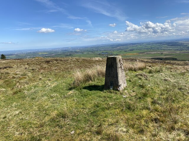
Faughlin Reservoir Images

Images are sourced within 2km of 56.023047/-4.0213885 or Grid Reference NS7482. Thanks to Geograph Open Source API. All images are credited.

Old fingerpost A photo taken in poor light showing the unique fingerpost at the crossroads just north of Carron Bridge which is the southernmost boundary of Stirlingshire with North Lanarkshire and Falkirk.  The only other recorded post of this style was, in 1983, at the junction of the A836 and B838 north of Lairg.  Now lost.
Old fingerpost
A photo taken in poor light showing the unique fingerpost at the crossroads just north of Carron Bridge which is the southernmost boundary of Stirlingshire with North Lanarkshire and Falkirk. The only other recorded post of this style was, in 1983, at the junction of the A836 and B838 north of Lairg. Now lost.
Old fingerpost A clearer view of the unique fingerpost at the crossroads on the B818 near Carron Bridge.  It was cast at the Smith and Wellstead Foundry in Bonnybridge and is the only known survivor in Scotland of this style of fingerpost with a 6" diameter ball finial and arrowhead ends to the fingers.
Old fingerpost
A clearer view of the unique fingerpost at the crossroads on the B818 near Carron Bridge. It was cast at the Smith and Wellstead Foundry in Bonnybridge and is the only known survivor in Scotland of this style of fingerpost with a 6" diameter ball finial and arrowhead ends to the fingers.
Old fingerpost This photograph shows the zigzag pattern of 4 inverted Vs cast around the post beneath the fingers of the unique fingerpost on the B818 near Carron Bridge.  The two lost fingers may have indicated the routes to Denny and Stirling.
Old fingerpost
This photograph shows the zigzag pattern of 4 inverted Vs cast around the post beneath the fingers of the unique fingerpost on the B818 near Carron Bridge. The two lost fingers may have indicated the routes to Denny and Stirling.
Minor road leaving the B818 at Carron Bridge Looking north-eastward. Signage suggests that this road leads to Stirling.
Minor road leaving the B818 at Carron Bridge
Looking north-eastward. Signage suggests that this road leads to Stirling.
Forestry track restricted to foot, hoof and cycle usage Looking south-westward.
Forestry track restricted to foot, hoof and cycle usage
Looking south-westward.
A somewhat overgrown and disused forestry track Looking eastward.
A somewhat overgrown and disused forestry track
Looking eastward.
Tak Ma Doon Road, Kilsyth Hills Looking southward from near to the entrance to the View Point Car Park.
Tak Ma Doon Road, Kilsyth Hills
Looking southward from near to the entrance to the View Point Car Park.
Cleared, replanted forest on Denny Muir The dense forest seen ten years ago in <a href="https://www.geograph.org.uk/photo/3485770">NS7582 : Forest, Denny Muir</a> has been felled and replanted. For now one has a clear view across the Denny Muir to Birns Hill and beyond.
Cleared, replanted forest on Denny Muir
The dense forest seen ten years ago in NS7582 : Forest, Denny Muir has been felled and replanted. For now one has a clear view across the Denny Muir to Birns Hill and beyond.
Birns hill A rocky knoll above the boggy moorland of Denny Muir. The dry stane dyke runs across the hill from the west.
Birns hill
A rocky knoll above the boggy moorland of Denny Muir. The dry stane dyke runs across the hill from the west.
Birns trig point The pillar is seen looking roughly west, with Tomtain at upper left.
Birns trig point
The pillar is seen looking roughly west, with Tomtain at upper left.
Earl's Burn View from the A818
Earl's Burn
View from the A818
River Carron Downstream of the dam and Forestry car park.
River Carron
Downstream of the dam and Forestry car park.
Start of track to Birns Hill
Nearly at the end of the track
Birns Hill on the horizon
Fence to be crossed on the way to Birns Hill
Birns Hill Trig Point Flush Bracket S3645
Show me another place!

Faughlin Reservoir is located at Grid Ref: NS7482 (Lat: 56.023047, Lng: -4.0213885)

Unitary Authority: North Lanarkshire

Police Authority: Lanarkshire

What 3 Words

///livid.flies.warnings. Near Banknock, Falkirk

Nearby Locations

Faughlin Reservoir

Related Wikis

Duncarron

Duncarron is a modern reproduction of a fortified village from the early Middle Ages of Scotland. It is the reconstruction of a typical residence of a...

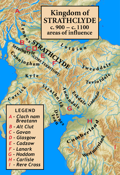
Kingdom of Strathclyde

Strathclyde (lit. "broad valley of the Clyde", Welsh: Ystrad Clud, Latin: Cumbria) was a Brittonic kingdom in northern Britain during the Middle Ages....

Banton, North Lanarkshire

Banton is a small village situated near Kilsyth in North Lanarkshire, Scotland. == History == The Covenanter army under General William Baillie formed...

Battle of Kilsyth

The Battle of Kilsyth, fought on 15 August 1645 near Kilsyth, was an engagement of the Wars of the Three Kingdoms. The largest battle of the conflict in...

Nearby Amenities

Located within 500m of 56.023047,-4.0213885
The data included in this document is from www.openstreetmap.org. The data is made available under ODbL.

Have you been to Faughlin Reservoir?

Leave your review of Faughlin Reservoir below (or comments, questions and feedback).