Llyn Cwmorthin

Lake, Pool, Pond, Freshwater Marsh in Merionethshire

Wales

Llyn Cwmorthin

Cwmorthin Waterfall, Above Tanygrisiau
Cwmorthin Waterfall, Above Tanygrisiau Credit: Brian Deegan

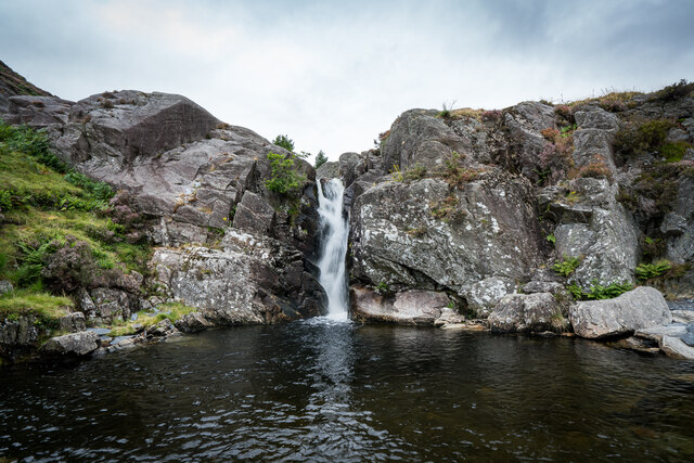
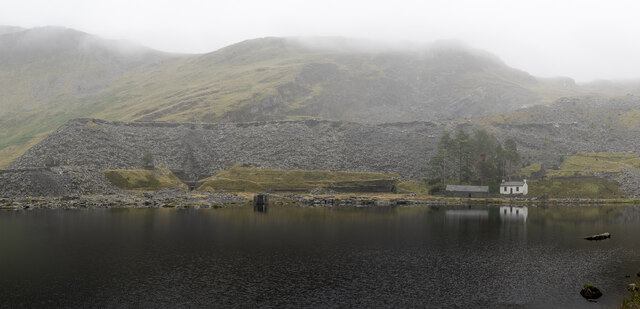
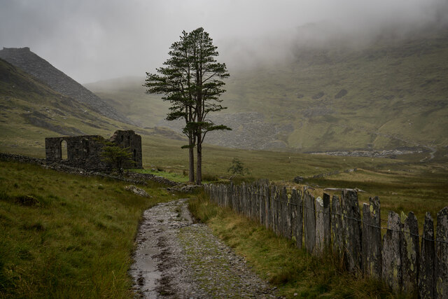
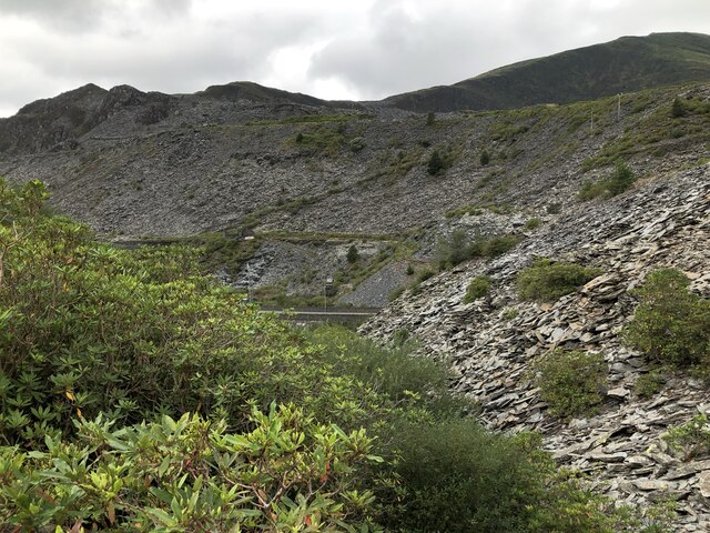
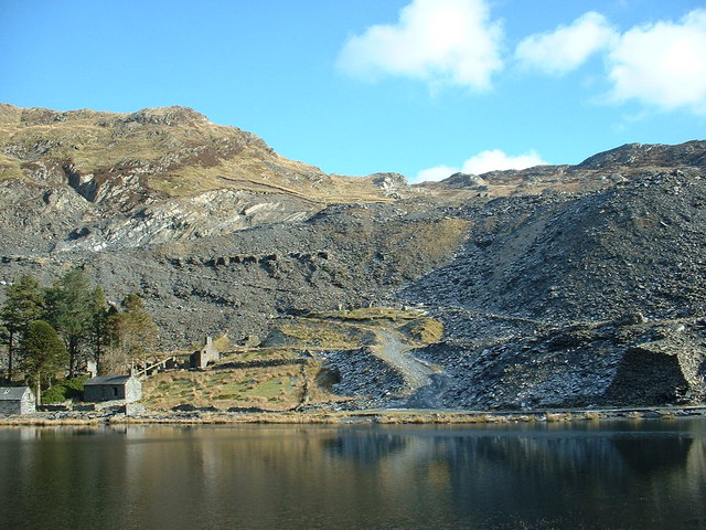
Llyn Cwmorthin, located in the county of Merionethshire in northwest Wales, is a picturesque freshwater lake nestled within the rugged and scenic landscape of Snowdonia National Park. This natural wonder is situated in the Cwmorthin Valley, surrounded by imposing mountains and steep cliffs, creating a dramatic backdrop.

The lake itself has a surface area of approximately 12 acres, with crystal-clear waters that reflect the surrounding mountains and sky. It is fed by several small streams and springs, ensuring a constant flow of fresh water. The lake's depth varies, reaching around 30 meters in some areas, making it a popular spot for diving enthusiasts.

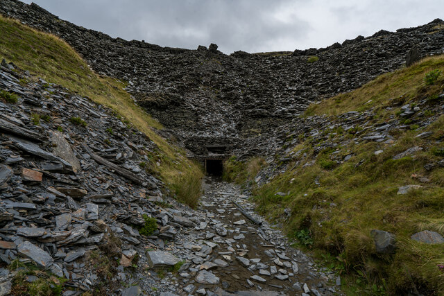
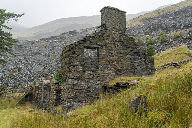
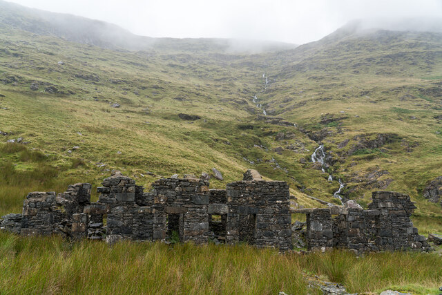
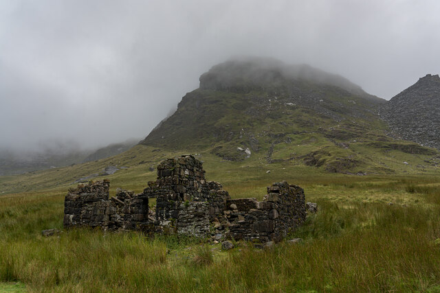
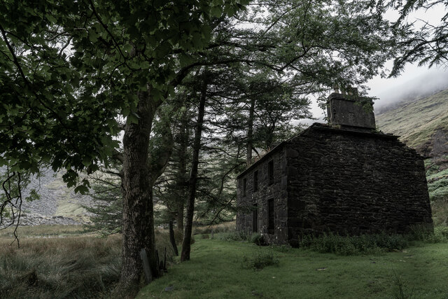
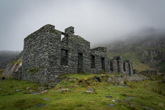
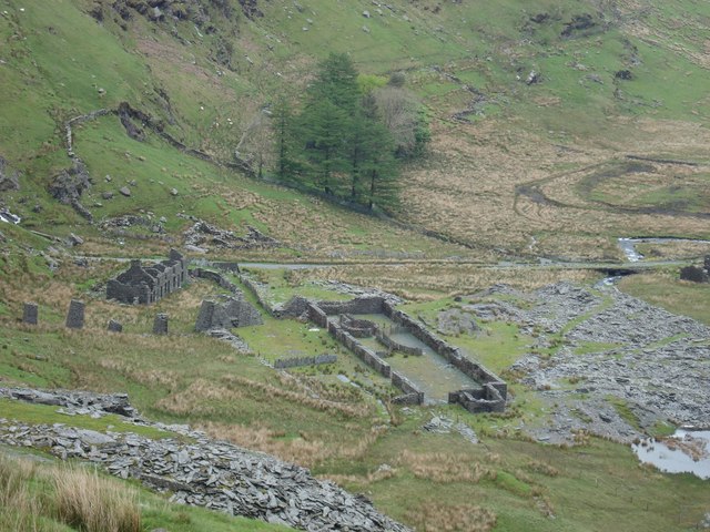
Surrounding the lake, there are remnants of the area's industrial past. Llyn Cwmorthin was once a crucial part of the slate mining industry during the 19th and early 20th centuries. The remains of old mine buildings, quarries, and tramways can be seen, adding a historical and atmospheric element to the landscape.

The lake and its surrounding area are now a haven for wildlife, with various species of birds, insects, and plants making it their home. It is particularly renowned for its diverse birdlife, including rare species such as the peregrine falcon and ring ouzel.

For outdoor enthusiasts, Llyn Cwmorthin offers a range of activities. Fishing is a popular pastime, with the lake stocked with brown trout. Hiking and walking trails abound in the area, providing stunning vistas and opportunities to explore the surrounding valleys and mountains.

Llyn Cwmorthin is a remarkable destination, combining natural beauty, a rich industrial heritage, and abundant wildlife, making it a must-visit location for nature lovers and history enthusiasts alike.

If you have any feedback on the listing, please let us know in the comments section below.

Llyn Cwmorthin Images

Images are sourced within 2km of 52.997109/-3.9719406 or Grid Reference SH6746. Thanks to Geograph Open Source API. All images are credited.

Cwmorthin Waterfall, Above Tanygrisiau
Cwmorthin Waterfall and Plunge Pool
Cwmorthin Quarry Mine Adit There is a gate inside the entrance with a chilly breeze blowing through it.

Cwmorthin quarry was a slate quarry west of the village of Tanygrisiau, north Wales. Quarrying on the site started in 1810. In 1860 it was connected to the Ffestiniog Railway. In 1900 it was acquired by the nearby Oakeley quarry and the two were connected underground. In 1970 it closed along with Oakeley. There was small-scale working in the 1980s and 1990s, and the mine finally closed in 1997.

<span class="nowrap"><a title="https://en.wikipedia.org/wiki/Cwmorthin_quarry" rel="nofollow ugc noopener" href="https://en.wikipedia.org/wiki/Cwmorthin_quarry">Link</a><img style="margin-left:2px;" alt="External link" title="External link - shift click to open in new window" src="https://s1.geograph.org.uk/img/external.png" width="10" height="10"/></span>
Cwmorthin Quarry Mine Adit
There is a gate inside the entrance with a chilly breeze blowing through it. Cwmorthin quarry was a slate quarry west of the village of Tanygrisiau, north Wales. Quarrying on the site started in 1810. In 1860 it was connected to the Ffestiniog Railway. In 1900 it was acquired by the nearby Oakeley quarry and the two were connected underground. In 1970 it closed along with Oakeley. There was small-scale working in the 1980s and 1990s, and the mine finally closed in 1997. LinkExternal link
Ruined Buildings, Cwmorthin Quarry <span class="nowrap"><a title="https://en.wikipedia.org/wiki/Cwmorthin_quarry" rel="nofollow ugc noopener" href="https://en.wikipedia.org/wiki/Cwmorthin_quarry">Link</a><img style="margin-left:2px;" alt="External link" title="External link - shift click to open in new window" src="https://s1.geograph.org.uk/img/external.png" width="10" height="10"/></span>
Ruined Buildings, Cwmorthin Quarry
Llyn Cwmorthin & Old Quarry Buildings <span class="nowrap"><a title="https://en.wikipedia.org/wiki/Cwmorthin_quarry" rel="nofollow ugc noopener" href="https://en.wikipedia.org/wiki/Cwmorthin_quarry">Link</a><img style="margin-left:2px;" alt="External link" title="External link - shift click to open in new window" src="https://s1.geograph.org.uk/img/external.png" width="10" height="10"/></span>
Llyn Cwmorthin & Old Quarry Buildings
Capel y Gorlan & Tree's, Cwmorthin Quarry Was a former Methodist Chapel built around the 1860's. The pair of trees and the location make it an imposing focal point.

<span class="nowrap"><a title="http://www.cwmorthin.com/4._capel_y_gorlan.html" rel="nofollow ugc noopener" href="http://www.cwmorthin.com/4._capel_y_gorlan.html">Link</a><img style="margin-left:2px;" alt="External link" title="External link - shift click to open in new window" src="https://s1.geograph.org.uk/img/external.png" width="10" height="10"/></span>

<span class="nowrap"><a title="https://en.wikipedia.org/wiki/Cwmorthin_quarry" rel="nofollow ugc noopener" href="https://en.wikipedia.org/wiki/Cwmorthin_quarry">Link</a><img style="margin-left:2px;" alt="External link" title="External link - shift click to open in new window" src="https://s1.geograph.org.uk/img/external.png" width="10" height="10"/></span>
Capel y Gorlan & Tree's, Cwmorthin Quarry
Was a former Methodist Chapel built around the 1860's. The pair of trees and the location make it an imposing focal point. LinkExternal link LinkExternal link
Rhosydd Terrace, Cwmorthin Quarry This is a row of six cottages built 1860s. Some very good information on the linked page, including Census information from 1871 when there were 27 people living here and 1881 where there were 41 people! With 13 people living in No 1 alone. <span class="nowrap"><a title="http://www.cwmorthin.com/6._tai_conglog.html" rel="nofollow ugc noopener" href="http://www.cwmorthin.com/6._tai_conglog.html">Link</a><img style="margin-left:2px;" alt="External link" title="External link - shift click to open in new window" src="https://s1.geograph.org.uk/img/external.png" width="10" height="10"/></span>
Rhosydd Terrace, Cwmorthin Quarry
This is a row of six cottages built 1860s. Some very good information on the linked page, including Census information from 1871 when there were 27 people living here and 1881 where there were 41 people! With 13 people living in No 1 alone. LinkExternal link
Rhosydd Stables, Cwmorthin Quarry Built in the late 1850’s by Rhosydd Quarry to home the ponies used to carry its slates through the valley.

<span class="nowrap"><a title="http://www.cwmorthin.com/rhosydd_stables.html" rel="nofollow ugc noopener" href="http://www.cwmorthin.com/rhosydd_stables.html">Link</a><img style="margin-left:2px;" alt="External link" title="External link - shift click to open in new window" src="https://s1.geograph.org.uk/img/external.png" width="10" height="10"/></span>
Rhosydd Stables, Cwmorthin Quarry
Built in the late 1850’s by Rhosydd Quarry to home the ponies used to carry its slates through the valley. LinkExternal link
Plas Cwmorthin Quarry Plas Cwmorthin, the Rhosydd Quarry manager’s house, was built in 1860.

<span class="nowrap"><a title="http://www.cwmorthin.com/7._plas_cwmorthin.html" rel="nofollow ugc noopener" href="http://www.cwmorthin.com/7._plas_cwmorthin.html">Link</a><img style="margin-left:2px;" alt="External link" title="External link - shift click to open in new window" src="https://s1.geograph.org.uk/img/external.png" width="10" height="10"/></span>
Plas Cwmorthin Quarry
Plas Cwmorthin, the Rhosydd Quarry manager’s house, was built in 1860. LinkExternal link
Cwmorthin Terrace (Tai Llyn) A total of thirteen Slate workers Houses. The first eight houses were erected in the 1860’s and constructed of dressed stone. A further five made of slate blocks (nearest the camera) were built in the 1870’s.

<span class="nowrap"><a title="http://www.cwmorthin.com/1._tai_llyn.html" rel="nofollow ugc noopener" href="http://www.cwmorthin.com/1._tai_llyn.html">Link</a><img style="margin-left:2px;" alt="External link" title="External link - shift click to open in new window" src="https://s1.geograph.org.uk/img/external.png" width="10" height="10"/></span>
Cwmorthin Terrace (Tai Llyn)
A total of thirteen Slate workers Houses. The first eight houses were erected in the 1860’s and constructed of dressed stone. A further five made of slate blocks (nearest the camera) were built in the 1870’s. LinkExternal link
Slate Waste, Blaenau Ffestiniog Slate waste around the slopes of former Llechwedd and Gloddfa Ganol slate mines.
Slate Waste, Blaenau Ffestiniog
Slate waste around the slopes of former Llechwedd and Gloddfa Ganol slate mines.
Llwyn-y-Gell Road, Blaenau Ffestiniog The A470, also known as the Cardiff to Glan Conwy Trunk Road, is the major long-distance road in Wales, from Cardiff on the south coast to Llandudno on the north coast. It is 185 miles long, and has undergone considerable road improvement in the last two decades. While previously one had to navigate the narrow roads of Llanidloes and Dolgellau, both these market towns are now bypassed due to extensive road modernisation.

The road travels through two of Wales's national parks, the Brecon Beacons in the South and Snowdonia National Park, starting just south of Dinas Mawddwy in the North. It is a primary trunk route throughout its length, and the southernmost 26 miles, from Cardiff Bay to Merthyr Tydfil, is mainly direct and good quality dual carriageway, but most of the route from north of Merthyr to Llandudno is single carriageway.
<span class="nowrap"><a title="http://www.sabre-roads.org.uk/wiki/index.php?title=A470" rel="nofollow ugc noopener" href="http://www.sabre-roads.org.uk/wiki/index.php?title=A470">Link</a><img style="margin-left:2px;" alt="External link" title="External link - shift click to open in new window" src="https://s1.geograph.org.uk/img/external.png" width="10" height="10"/></span>  SABRE
Llwyn-y-Gell Road, Blaenau Ffestiniog
The A470, also known as the Cardiff to Glan Conwy Trunk Road, is the major long-distance road in Wales, from Cardiff on the south coast to Llandudno on the north coast. It is 185 miles long, and has undergone considerable road improvement in the last two decades. While previously one had to navigate the narrow roads of Llanidloes and Dolgellau, both these market towns are now bypassed due to extensive road modernisation. The road travels through two of Wales's national parks, the Brecon Beacons in the South and Snowdonia National Park, starting just south of Dinas Mawddwy in the North. It is a primary trunk route throughout its length, and the southernmost 26 miles, from Cardiff Bay to Merthyr Tydfil, is mainly direct and good quality dual carriageway, but most of the route from north of Merthyr to Llandudno is single carriageway. LinkExternal link SABRE
A496, Blaenau Ffestiniog The A496 is a major coastal and mountainous road in southern Snowdonia. It runs for almost 33 miles from Blaenau Ffestiniog to Llanelltyd, via Harlech. The road passes through a diverse landscape, including the mountainous region of Blaenau Ffestiniog.
A496, Blaenau Ffestiniog
The A496 is a major coastal and mountainous road in southern Snowdonia. It runs for almost 33 miles from Blaenau Ffestiniog to Llanelltyd, via Harlech. The road passes through a diverse landscape, including the mountainous region of Blaenau Ffestiniog.
A496, Pencefn Road near to Tanygrisiau The A496 is a major coastal and mountainous road in southern Snowdonia. It runs for almost 33 miles from Blaenau Ffestiniog to Llanelltyd, via Harlech. The road passes through a diverse landscape, including the mountainous region of Blaenau Ffestiniog.
A496, Pencefn Road near to Tanygrisiau
The A496 is a major coastal and mountainous road in southern Snowdonia. It runs for almost 33 miles from Blaenau Ffestiniog to Llanelltyd, via Harlech. The road passes through a diverse landscape, including the mountainous region of Blaenau Ffestiniog.
Variation on a theme There is a currently popular piece of graffiti which reads "Cofiwch Dryweryn" (Remember Tryweryn - the village drowned to supply water for Liverpool). The original is on a wall near Aberystwyth, but it is now much copied around north Wales. 
In the same style, this sign exorts passers-by to "Remember Cwmorthin", presumably as a reference to the slate quarrying which has 'spoilt' the valley.
Variation on a theme
There is a currently popular piece of graffiti which reads "Cofiwch Dryweryn" (Remember Tryweryn - the village drowned to supply water for Liverpool). The original is on a wall near Aberystwyth, but it is now much copied around north Wales. In the same style, this sign exorts passers-by to "Remember Cwmorthin", presumably as a reference to the slate quarrying which has 'spoilt' the valley.
Approaching Tanygrisiau Approaching Tanygrisiau on the A496, with the village beneath the mountains.
Approaching Tanygrisiau
Approaching Tanygrisiau on the A496, with the village beneath the mountains.
Yr Moelwyniau Yr Moelwyniau oddi wrth Llan Ffestiniog, Cymru.

Moelwyn mountains viewed from Llan Ffestiniog, Wales. Ref:PC200045.
Yr Moelwyniau
Yr Moelwyniau oddi wrth Llan Ffestiniog, Cymru. Moelwyn mountains viewed from Llan Ffestiniog, Wales. Ref:PC200045.
Yr Moelwynau, Eryri Four peaks of the Moelwyn mountains (L to R): Moelwyn Bach (710m), Craigysgefn (689m), Moelwyn Mawr (770m) and Moel-yr-hydd (647m). View from across the valley from Llan Ffestiniog. Ref:PC200045a.
Yr Moelwynau, Eryri
Four peaks of the Moelwyn mountains (L to R): Moelwyn Bach (710m), Craigysgefn (689m), Moelwyn Mawr (770m) and Moel-yr-hydd (647m). View from across the valley from Llan Ffestiniog. Ref:PC200045a.
Show me another place!

Llyn Cwmorthin is located at Grid Ref: SH6746 (Lat: 52.997109, Lng: -3.9719406)

Unitary Authority: Gwynedd

Police Authority: North Wales

What 3 Words

///maple.whites.objecting. Near Blaenau-Ffestiniog, Gwynedd

Related Wikis

Cwmorthin quarry

Cwmorthin quarry was a slate quarry west of the village of Tanygrisiau, north Wales. Quarrying on the site started in 1810. In 1860 it was connected to...

Wrysgan quarry

Wrysgan quarry was a slate quarry near the village of Tanygrisiau, Blaenau Festiniog, North Wales. It was worked intermittently from the 1830s, and was...

Conglog quarry

Conglog quarry was a small enterprise situated to the north-west of Tanygrisiau, near Blaenau Ffestiniog in Wales. It was overshadowed by the much bigger...

Moel-yr-hydd

Moel-yr-hydd is a subsidiary summit of Moelwyn Mawr in Snowdonia, North Wales and forms part of the Moelwynion. (Strictly the mountain is not actually...

Deep Sleep (hotel)

Deep Sleep is an underground hotel located in Wales. It is built 1,375 feet (419 m) below ground level, inside an abandoned mine in Cwmorthin quarry in...

Allt-fawr

Allt-fawr is a mountain in Snowdonia, North Wales and forms part of the Moelwynion group. It is on the internal border of Snowdonia National Park, and...

Nyth-y-Gigfran quarry

Nyth-y-Gigfran quarry (sometimes spelt: Nith-y-Gigfran or Nidd-y-Gigfran; sometimes known as Glan-y-Pwll quarry) was a slate quarry in the town of Blaenau...

Rhosydd quarry

Rhosydd quarry was a slate quarry in the Moelwyn mountains, northeast of Porthmadog in North Wales. Small-scale working of the site began in the 1830s...

Nearby Amenities

Located within 500m of 52.997109,-3.9719406
Source: npe
Lat/Long: 53.0003946/-3.9739111
Source: npe
Lat/Long: 52.9999836/-3.9720938
Source: npe
Lat/Long: 52.9980409/-3.972106
Source: npe
Lat/Long: 52.9973872/-3.9708381
Source: npe
Lat/Long: 52.9971095/-3.9701362
Source: npe
Lat/Long: 52.9965526/-3.9693159
Source: npe
Lat/Long: 52.9951808/-3.9697213
Source: npe
Lat/Long: 52.9973411/-3.9730411
Source: npe
Lat/Long: 52.9990629/-3.9746925
Source: npe
Lat/Long: 52.9941587/-3.9688977
Cwmorthin Slate Mine Entrance
Description: Back seam 1 - Lake level - Floor 1 North
Man Made: adit
Lat/Long: 52.9978836/-3.9688819
Floor 2 South Adit
Man Made: adit
Note: aka "the Smoke Flue Adit"
Lat/Long: 52.9963189/-3.9676633
Ford: yes
Lat/Long: 52.9950265/-3.969557
Man Made: adit
Lat/Long: 52.9999649/-3.9694754
Man Made: adit
Lat/Long: 53.0001266/-3.9674292
Man Made: adit
Lat/Long: 53.0001106/-3.9674736
Man Made: adit
Lat/Long: 53.00005/-3.9674829
The data included in this document is from www.openstreetmap.org. The data is made available under ODbL.

Have you been to Llyn Cwmorthin?

Leave your review of Llyn Cwmorthin below (or comments, questions and feedback).