Mill Dam

Lake, Pool, Pond, Freshwater Marsh in Stirlingshire

Scotland

Mill Dam

Track leading to Slackdhu above Strathblane
Track leading to Slackdhu above Strathblane Credit: Chris Upson

Mill Dam is a picturesque freshwater marsh located in Stirlingshire, Scotland. Situated in a tranquil setting, it is a popular destination for nature lovers and outdoor enthusiasts. The dam itself is a man-made structure, created to retain water and provide a habitat for various aquatic species.

Covering an area of approximately 2 hectares, Mill Dam is surrounded by lush vegetation, including reeds, rushes, and water lilies. The diverse plant life provides a haven for a wide range of wildlife, including birds, insects, and amphibians. Visitors can often spot species such as herons, ducks, and dragonflies, as well as rare plants like the marsh cinquefoil.

The calm waters of Mill Dam support a healthy population of fish, making it a favorite spot for anglers. Common fish species found in the dam include perch, roach, and pike. Fishing permits are available for those who wish to try their luck in these waters.

The area around Mill Dam is also home to several walking trails, allowing visitors to explore the natural beauty of the surrounding countryside. The peaceful ambiance and stunning views make it an ideal location for a leisurely stroll or a picnic by the water's edge.

Overall, Mill Dam in Stirlingshire offers a serene and idyllic escape from the hustle and bustle of everyday life. With its diverse wildlife, picturesque views, and recreational activities, it is a must-visit destination for nature enthusiasts and those seeking a peaceful retreat in the heart of Scotland.

If you have any feedback on the listing, please let us know in the comments section below.

Mill Dam Images

Images are sourced within 2km of 55.97953/-4.3056717 or Grid Reference NS5678. Thanks to Geograph Open Source API. All images are credited.

Track leading to Slackdhu above Strathblane
Ballagan Burn The burn looks relatively placid here, but it is about to tumble over the Spout of Ballagan.
Ballagan Burn
The burn looks relatively placid here, but it is about to tumble over the Spout of Ballagan.
Very old signpost on the A81 I'm sure no-one nowadays needs directions to the Glasgow Royal Exchange, and the only evidence I can find for Aberfoyle being spelled Aberfoil is on an 1863 map, so how old is this milepost?! Impressive.
Very old signpost on the A81
I'm sure no-one nowadays needs directions to the Glasgow Royal Exchange, and the only evidence I can find for Aberfoyle being spelled Aberfoil is on an 1863 map, so how old is this milepost?! Impressive.
Campsie Dene Road From the town/country boundary, looking towards Campsie Dene House.
Campsie Dene Road
From the town/country boundary, looking towards Campsie Dene House.
The Spout of Ballagan This 21-metre fall is a highlight of the area. It displays a classic section of the calciferous sandstones called the Ballagan Beds. There is a fine building sandstone, Spout of Ballagan sandstone, at the top which is hard enough to cause the fall, and beneath it are alternating layers of cementstones & shales. These were laid down in the Carboniferous era c350million years ago when this whole area was the bed of a tropical lagoon south of the equator. Park in the village of Strathblane (opposite the church) & walk along the road to the entrance to Ballagan House. At the back of this is a stile & sign that takes you up to the nature reserve and fall. The actual approach to the foot of the fall is quite rough going but the path takes you to the top of it easily from where you can continue on up onto The Campsies.
The Spout of Ballagan
This 21-metre fall is a highlight of the area. It displays a classic section of the calciferous sandstones called the Ballagan Beds. There is a fine building sandstone, Spout of Ballagan sandstone, at the top which is hard enough to cause the fall, and beneath it are alternating layers of cementstones & shales. These were laid down in the Carboniferous era c350million years ago when this whole area was the bed of a tropical lagoon south of the equator. Park in the village of Strathblane (opposite the church) & walk along the road to the entrance to Ballagan House. At the back of this is a stile & sign that takes you up to the nature reserve and fall. The actual approach to the foot of the fall is quite rough going but the path takes you to the top of it easily from where you can continue on up onto The Campsies.
A81 milepost An iron milepost, one of several on the road. If not local and travelling from the north, the Glasgow 12 takes a bit of believing. Here in Strathblane there is little evidence (other than the traffic) that the centre of a great city is only 19km distant.

Note the spelling - probably an alternative now lost, chosen for brevity over Aberfoyle.
A81 milepost
An iron milepost, one of several on the road. If not local and travelling from the north, the Glasgow 12 takes a bit of believing. Here in Strathblane there is little evidence (other than the traffic) that the centre of a great city is only 19km distant. Note the spelling - probably an alternative now lost, chosen for brevity over Aberfoyle.
Scarp above East Ballewan A section of Strathblane: Lush grassland on the floor, woodland and steep craggy basalt crags.
Scarp above East Ballewan
A section of Strathblane: Lush grassland on the floor, woodland and steep craggy basalt crags.
Ballagan Glen The wooded gorge of Ballagan Glen, just below the Spout of Ballagan (waterfall).  The site is a Scottish Wildlife Trust Reserve and a Site of Special Scientific Interest on account of its geology.
Ballagan Glen
The wooded gorge of Ballagan Glen, just below the Spout of Ballagan (waterfall). The site is a Scottish Wildlife Trust Reserve and a Site of Special Scientific Interest on account of its geology.
The Ballagan Beds, Ballagan Glen The rock face shows the Ballagan Beds, a sequence of cementstones and mudstones of Carboniferous age.
The Ballagan Beds, Ballagan Glen
The rock face shows the Ballagan Beds, a sequence of cementstones and mudstones of Carboniferous age.
Strathblane Hills Long range photo from Muirhouse Muir.
Strathblane Hills
Long range photo from Muirhouse Muir.
1856 valve house, Blane Valley One of five valve houses built as part of the Glasgow Corporation Water Works system to bring clean water from Loch Katrine to Glasgow. This is one of the original three built in 1856, and another, built in 1932 stands close by. These buildings, together with an associated ventilation shaft, and walls, make up a group of buildings which are Category C listed [<span class="nowrap"><a title="http://portal.historicenvironment.scot/designation/LB51146" rel="nofollow ugc noopener" href="http://portal.historicenvironment.scot/designation/LB51146">Link</a><img style="margin-left:2px;" alt="External link" title="External link - shift click to open in new window" src="https://s1.geograph.org.uk/img/external.png" width="10" height="10"/></span>].
1856 valve house, Blane Valley
One of five valve houses built as part of the Glasgow Corporation Water Works system to bring clean water from Loch Katrine to Glasgow. This is one of the original three built in 1856, and another, built in 1932 stands close by. These buildings, together with an associated ventilation shaft, and walls, make up a group of buildings which are Category C listed [LinkExternal link].
Valve houses and ventilation shaft, Blane Valley On the left is one of the original 1856 valve houses from the Glasgow Corporation Water Works system which brought clean water from Loch Katrine to Glasgow. On the right is one of the 1932 valve houses. Both were built to control the flow of water in the large water pipes which run mainly below the ground. In the background is one of the ventilation shafts, above one of the pipes, with its very distinctive domed covering. The three structures, together with surrounding walls are Category B listed [<span class="nowrap"><a title="http://portal.historicenvironment.scot/designation/LB51146" rel="nofollow ugc noopener" href="http://portal.historicenvironment.scot/designation/LB51146">Link</a><img style="margin-left:2px;" alt="External link" title="External link - shift click to open in new window" src="https://s1.geograph.org.uk/img/external.png" width="10" height="10"/></span>].
Valve houses and ventilation shaft, Blane Valley
On the left is one of the original 1856 valve houses from the Glasgow Corporation Water Works system which brought clean water from Loch Katrine to Glasgow. On the right is one of the 1932 valve houses. Both were built to control the flow of water in the large water pipes which run mainly below the ground. In the background is one of the ventilation shafts, above one of the pipes, with its very distinctive domed covering. The three structures, together with surrounding walls are Category B listed [LinkExternal link].
Campsie Dene Road Looking towards Dumgoyne (just visible between the trees) from beside the entrance to Campsie Dene, one of several large houses built beside the road.
Campsie Dene Road
Looking towards Dumgoyne (just visible between the trees) from beside the entrance to Campsie Dene, one of several large houses built beside the road.
Gate beside the track Overlooking the Blane Valley.
Gate beside the track
Overlooking the Blane Valley.
Track up the hill The track leads through the gate and then up towards the slopes of Slackdhu.
Track up the hill
The track leads through the gate and then up towards the slopes of Slackdhu.
The Campsie Fells from the air The Strathblane Hills are in the foreground with the Campsie Fells beyond.
The Campsie Fells from the air
The Strathblane Hills are in the foreground with the Campsie Fells beyond.
Ballagan Glen The wooded gorge of Ballagan Glen, just below the Spout of Ballagan (waterfall). The site is a Scottish Wildlife Trust Reserve and a Site of Special Scientific Interest on account of its geology.
Ballagan Glen
The wooded gorge of Ballagan Glen, just below the Spout of Ballagan (waterfall). The site is a Scottish Wildlife Trust Reserve and a Site of Special Scientific Interest on account of its geology.
The Ballagan Beds, Ballagan Glen The rock face shows the Ballagan Beds, a sequence of cementstones and mudstones of Carboniferous age, named after their occurrence here. The height of the cliff is apparent from the size of the person at the bottom right.
The Ballagan Beds, Ballagan Glen
The rock face shows the Ballagan Beds, a sequence of cementstones and mudstones of Carboniferous age, named after their occurrence here. The height of the cliff is apparent from the size of the person at the bottom right.
Show me another place!

Mill Dam is located at Grid Ref: NS5678 (Lat: 55.97953, Lng: -4.3056717)

Unitary Authority: Stirling

Police Authority: Forth Valley

What 3 Words

///pigs.cafe.astounded. Near Strathblane, Stirling

Nearby Locations

Mill Dam

Related Wikis

Strathblane railway station

Strathblane railway station served the village of Strathblane, Stirling, Scotland from 1867 to 1951 on the Blane Valley Railway. == History == The station...
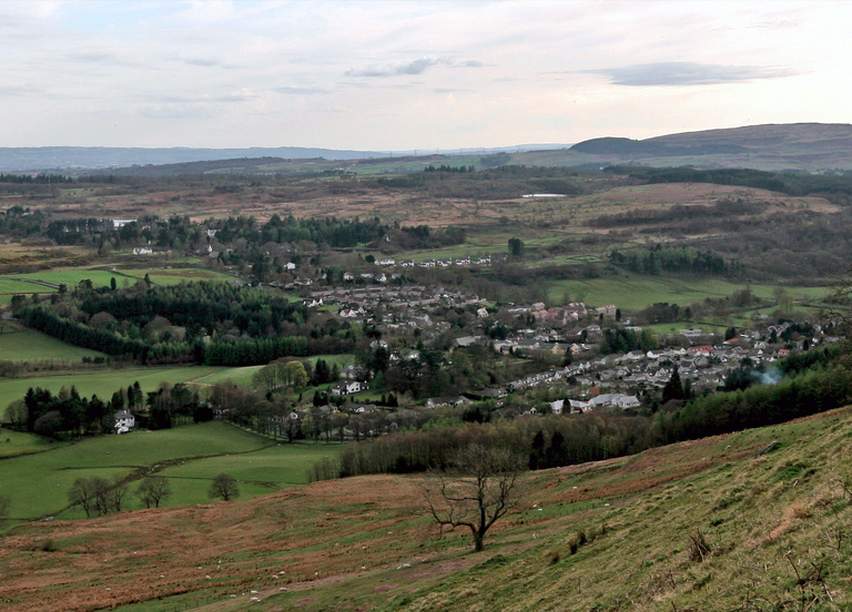
Blanefield

Blanefield is a settlement in Scotland contiguous with Strathblane's northwestern fringe. To the west is the volcanic plug Dumgoyne, Glengoyne Distillery...

Strathblane

Strathblane (Scottish Gaelic: Strath Bhlàthain, pronounced [s̪t̪ɾahˈvl̪ˠaː.ɪɲ]) is a village and parish in the registration county of Stirlingshire, situated...
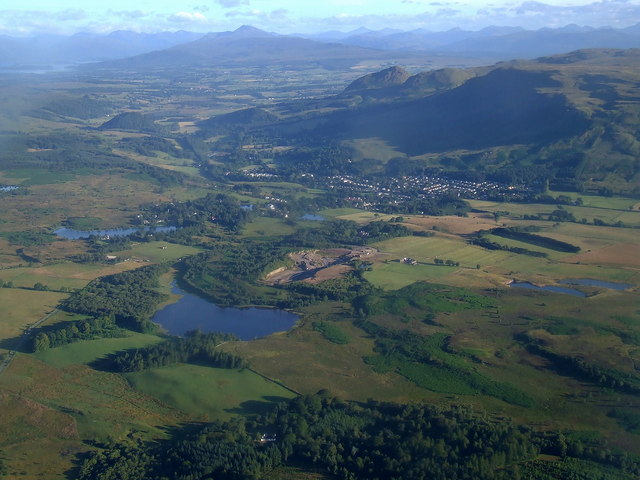
Loch Ardinning

Loch Ardinning (Scottish Gaelic: Loch Àird Dùnain) is a body of freshwater in the district of Stirling in Scotland, lying to the south of the village of...

Nearby Amenities

Located within 500m of 55.97953,-4.3056717
Post Box
Postal Code: G63 9
Ref: G63 612
Lat/Long: 55.983886/-4.3065423
Post Office
Strathblane Post Office
Addr Postcode: G63 9EJ
Branch: Strathblane
Brand: Post Office
Brand Wikidata: Q1783168
Check Date: 2020-02-20
Contact Website: https://www.postoffice.co.uk/branch-finder/2218550/strathblane
Ref Pol Id: 8311
Lat/Long: 55.9838829/-4.3063041
Power: pole
Lat/Long: 55.9819876/-4.3123878
Power: pole
Lat/Long: 55.9819641/-4.3112437
Power: pole
Lat/Long: 55.9817414/-4.3098943
Bus Stop
Bench: no
Bus: yes
Public Transport: platform
Shelter: yes
Lat/Long: 55.9803088/-4.3027547
Bus Stop
Bus: yes
Public Transport: platform
Shelter: no
Lat/Long: 55.9810166/-4.3030153
The data included in this document is from www.openstreetmap.org. The data is made available under ODbL.

Have you been to Mill Dam?

Leave your review of Mill Dam below (or comments, questions and feedback).