Burncrooks Reservoir

Lake, Pool, Pond, Freshwater Marsh in Stirlingshire

Scotland

Burncrooks Reservoir

Near the southern end of The Whangie The south-western entrance to The Whangie, a rock fissure in the cliff that folklore has it was caused by the devil flicking his tail as he flew past, is just ahead on the right.

The snowfall happened on the northern flank of Storm Eunice, which caused much damage south of the border.
Near the southern end of The Whangie Credit: Alan O'Dowd

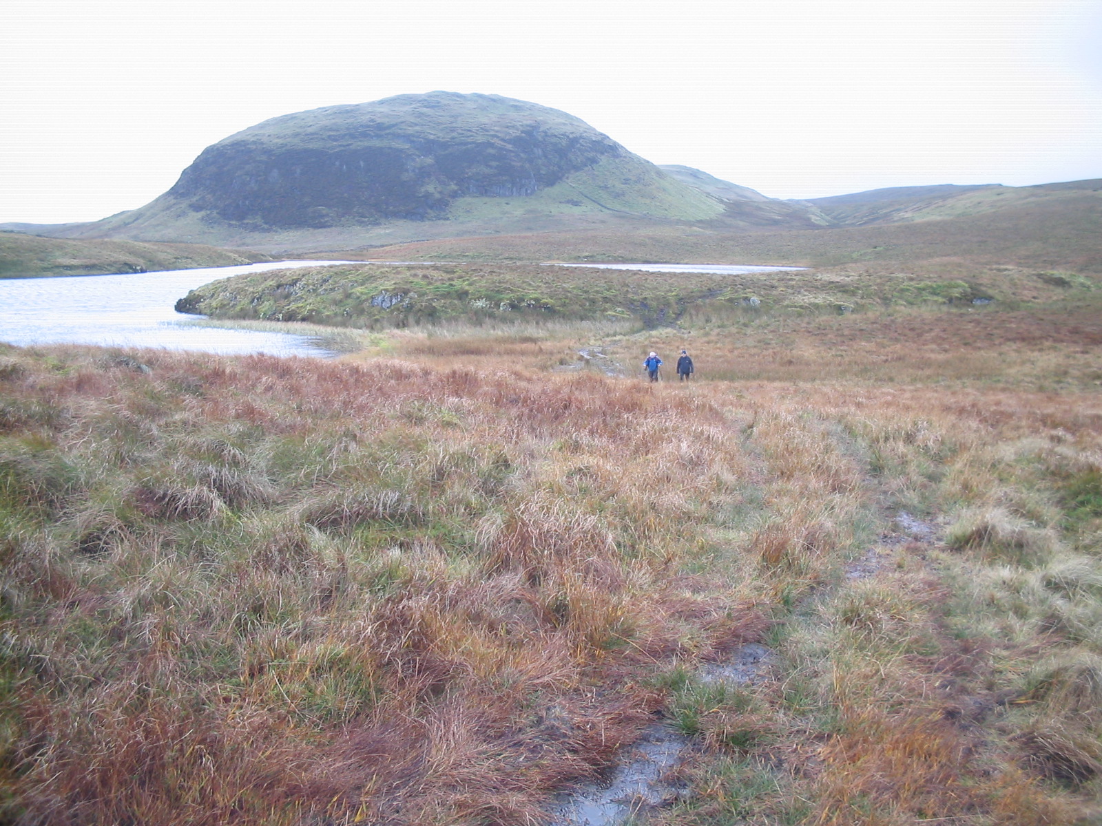
Burncrooks Reservoir is a man-made freshwater reservoir located in Stirlingshire, Scotland. Originally constructed in the 19th century to supply water to nearby towns and villages, it has since become a popular spot for outdoor recreation and wildlife observation.

The reservoir covers an area of approximately 21 hectares and is surrounded by rolling hills and forests, providing a picturesque backdrop for visitors. The water is clear and clean, making it suitable for a variety of water-based activities such as fishing, boating, and kayaking.

The reservoir is home to a diverse range of flora and fauna, including waterfowl, fish, and aquatic plants. Birdwatchers can spot species such as herons, swans, and ducks along the shoreline, while anglers can try their hand at catching trout and perch in the deeper waters.

Visitors can access Burncrooks Reservoir via a network of walking trails that wind through the surrounding countryside, offering stunning views of the water and surrounding landscape. The reservoir is a peaceful and tranquil spot, perfect for those looking to escape the hustle and bustle of city life and reconnect with nature.

If you have any feedback on the listing, please let us know in the comments section below.

Burncrooks Reservoir Images

Images are sourced within 2km of 55.981356/-4.4276949 or Grid Reference NS4879. Thanks to Geograph Open Source API. All images are credited.

Near the southern end of The Whangie The south-western entrance to The Whangie, a rock fissure in the cliff that folklore has it was caused by the devil flicking his tail as he flew past, is just ahead on the right.

The snowfall happened on the northern flank of Storm Eunice, which caused much damage south of the border.
Near the southern end of The Whangie
The south-western entrance to The Whangie, a rock fissure in the cliff that folklore has it was caused by the devil flicking his tail as he flew past, is just ahead on the right. The snowfall happened on the northern flank of Storm Eunice, which caused much damage south of the border.
The summit of Auchineden hill This hill is situated at the northern edge of the Kilpatrick hills and enjoys a magnificent view over Loch Lomond and the Highland Line in one direction and another superb view south over Glasgow and the Central Lowlands with views all the way to Tinto.
The summit of Auchineden hill
This hill is situated at the northern edge of the Kilpatrick hills and enjoys a magnificent view over Loch Lomond and the Highland Line in one direction and another superb view south over Glasgow and the Central Lowlands with views all the way to Tinto.
The Whangie This strange rock formation which is scots for slash or slice has been a favourite haunt for generations of rock climbers, It is about 300ft long by about 50ft high. My photo only shows a very small part of this magnificent geological feature which at the present offers excellent views of Loch Lomond but that may change with an encroaching forest.
The Whangie
This strange rock formation which is scots for slash or slice has been a favourite haunt for generations of rock climbers, It is about 300ft long by about 50ft high. My photo only shows a very small part of this magnificent geological feature which at the present offers excellent views of Loch Lomond but that may change with an encroaching forest.
Whangie in the snow
Whangie in the snow
Whangie in  the snow
Whangie in the snow
Stile into the forest This path is on the course of a pipeline out of Burncrooks Reservoir.
Stile into the forest
This path is on the course of a pipeline out of Burncrooks Reservoir.
A Dreich Day Forest edge near The Whangie, with Loch Lomond and Conic hill barely visible in the distance through the rain.
A Dreich Day
Forest edge near The Whangie, with Loch Lomond and Conic hill barely visible in the distance through the rain.
Fence along Forest Edge A fence along the edge of a forest plantation, taken from the top of the oddly named Tenpence with The Whangie in the distance.
Fence along Forest Edge
A fence along the edge of a forest plantation, taken from the top of the oddly named Tenpence with The Whangie in the distance.
The Whangie Rock formation and cliffs which make up a popular climbing and walking spot, over looking Loch Lomond and The Campsie Fells.
The Whangie
Rock formation and cliffs which make up a popular climbing and walking spot, over looking Loch Lomond and The Campsie Fells.
Trig Point on Auchineden Hill
The Whangie
The Whangie
A Narrow Part of the Whangie This passage is less than one metre across in many places.
A Narrow Part of the Whangie
This passage is less than one metre across in many places.
Auchineden Hill Trig Point The western end of the Campsie Fells can be seen in the background.
Auchineden Hill Trig Point
The western end of the Campsie Fells can be seen in the background.
The Whangie Narrow path through the rocks of Auchineden Hill. The Whangie is a stone corridor, that was allegedly created by the devil flicking his tail with the oncoming excitement of visiting Stockie Muir!
The Whangie
Narrow path through the rocks of Auchineden Hill. The Whangie is a stone corridor, that was allegedly created by the devil flicking his tail with the oncoming excitement of visiting Stockie Muir!
Hill near edge of forest This small rounded hill stands close to a fence that bounds the edge of the forest. Near the hill, there is a gate in that fence, and some forest clearings (see the 1:25000 map) end there. The photograph was taken from a point close to the gate.

The hills is called Knockvadie: see <a href="https://www.geograph.org.uk/photo/4980424">NS4780 : The John Muir Way passing Knockvadie</a> and <a href="https://www.geograph.org.uk/photo/4980420">NS4780 : The John Muir Way passing Knockvadie</a> for views of a path passing this hill. That path did not exist when the present picture was taken. The first of those links explains the meaning of the name Knockvadie.
Hill near edge of forest
This small rounded hill stands close to a fence that bounds the edge of the forest. Near the hill, there is a gate in that fence, and some forest clearings (see the 1:25000 map) end there. The photograph was taken from a point close to the gate. The hills is called Knockvadie: see NS4780 : The John Muir Way passing Knockvadie and NS4780 : The John Muir Way passing Knockvadie for views of a path passing this hill. That path did not exist when the present picture was taken. The first of those links explains the meaning of the name Knockvadie.
Rock outcrop near the Whangie The name of the Whangie, a dramatic geological fissure, comes from the old Scots verb "whang" (which is related to the word "thong", in the sense of a whip), and has the meaning of cutting, beating, chopping, or striking with a sudden slashing movement. (It is given in the form "Wanzie" on the first-edition OS map; regarding such "z" spellings in old Scottish names, see <a title="https://www.geograph.org.uk/photo/1055008" href="https://www.geograph.org.uk/photo/1055008">Link</a> for more information.)

The name relates to a legend that the Devil rounded the corner of the hill here in great haste, and that the whipping of his tail created the deep fissure.

The rock outcrop shown here, like a crouching figure on the hillside, stands just west of the Whangie itself. Loch Lomond and its islands can be seen in the background.

See also <a href="https://www.geograph.org.uk/photo/1092734">NS4980 : Western side of the Whangie</a> and <a href="https://www.geograph.org.uk/photo/1092786">NS4980 : Southern entrance of the Whangie</a>.
Rock outcrop near the Whangie
The name of the Whangie, a dramatic geological fissure, comes from the old Scots verb "whang" (which is related to the word "thong", in the sense of a whip), and has the meaning of cutting, beating, chopping, or striking with a sudden slashing movement. (It is given in the form "Wanzie" on the first-edition OS map; regarding such "z" spellings in old Scottish names, see Link for more information.) The name relates to a legend that the Devil rounded the corner of the hill here in great haste, and that the whipping of his tail created the deep fissure. The rock outcrop shown here, like a crouching figure on the hillside, stands just west of the Whangie itself. Loch Lomond and its islands can be seen in the background. See also NS4980 : Western side of the Whangie and NS4980 : Southern entrance of the Whangie.
Western side of the Whangie On the name "Whangie", see: <a href="https://www.geograph.org.uk/photo/1092723">NS4980 : Rock outcrop near the Whangie</a>.

The deep narrow fissure of the Whangie itself lies on the other side of the wall of rock that is visible in the right of the photo.

See also <a href="https://www.geograph.org.uk/photo/1092786">NS4980 : Southern entrance of the Whangie</a>.
Western side of the Whangie
On the name "Whangie", see: NS4980 : Rock outcrop near the Whangie. The deep narrow fissure of the Whangie itself lies on the other side of the wall of rock that is visible in the right of the photo. See also NS4980 : Southern entrance of the Whangie.
Southern entrance of the Whangie The meaning of the word "Whangie" is explained here: <a href="https://www.geograph.org.uk/photo/1092723">NS4980 : Rock outcrop near the Whangie</a>.

The Whangie (created, as legend would have it, by the Devil whipping his tail in excitement as he flew round the corner of the hill here) is a deep narrow fissure, running in a north-south direction, and bounded on both sides by steep walls of rock.

After having passed through the narrow passage itself, from north to south, I paused to look back and take this image of the southern end, from which I had just emerged.

The northern entrance is shown here: <a href="https://www.geograph.org.uk/photo/40341">NS4980 : The Whangie</a>. For views of the narrow passage, see <a href="https://www.geograph.org.uk/photo/951768">NS4980 : A Narrow Part of the Whangie</a> and <a href="https://www.geograph.org.uk/photo/1014076">NS4980 : The Whangie</a>.

See also <a href="https://www.geograph.org.uk/photo/1092734">NS4980 : Western side of the Whangie</a>.
Southern entrance of the Whangie
The meaning of the word "Whangie" is explained here: NS4980 : Rock outcrop near the Whangie. The Whangie (created, as legend would have it, by the Devil whipping his tail in excitement as he flew round the corner of the hill here) is a deep narrow fissure, running in a north-south direction, and bounded on both sides by steep walls of rock. After having passed through the narrow passage itself, from north to south, I paused to look back and take this image of the southern end, from which I had just emerged. The northern entrance is shown here: NS4980 : The Whangie. For views of the narrow passage, see NS4980 : A Narrow Part of the Whangie and NS4980 : The Whangie. See also NS4980 : Western side of the Whangie.
Show me another place!

Burncrooks Reservoir is located at Grid Ref: NS4879 (Lat: 55.981356, Lng: -4.4276949)

Unitary Authority: Stirling

Police Authority: Forth Valley

What 3 Words

///tablets.argued.craft. Near Duntocher, West Dunbartonshire

Nearby Locations

Burncrooks Reservoir

Related Wikis

Kilpatrick Hills

The Kilpatrick Hills are a range of hills in central Scotland, stretching from Dumbarton in the west to Strathblane in the east. Strathblane divides the...

Duncolm

Duncolm (Scottish Gaelic: Dùn Choluim) is a hill in Scotland. It is the highest point in both West Dunbartonshire and the Kilpatrick Hills, at an elevation...

Clydebank (district)

Clydebank (Scottish Gaelic: Bruach Chluaidh) was, from 1975 to 1996, one of nineteen local government districts in the Strathclyde region of Scotland,...

Carbeth

Carbeth is a hamlet in Stirlingshire, 2.5 miles (4 km) west of Strathblane and 5.5 miles (9 km) north of Clydebank. Named features include Carbeth Hill...

Nearby Amenities

Located within 500m of 55.981356,-4.4276949
The data included in this document is from www.openstreetmap.org. The data is made available under ODbL.

Have you been to Burncrooks Reservoir?

Leave your review of Burncrooks Reservoir below (or comments, questions and feedback).