Bogton Loch

Lake, Pool, Pond, Freshwater Marsh in Ayrshire

Scotland

Bogton Loch

Arriving at Dalmellington On the A713 from Carsphairn.
Arriving at Dalmellington Credit: Billy McCrorie

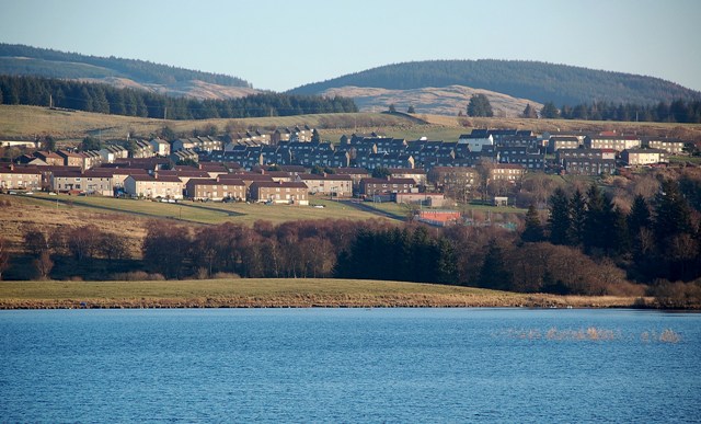
Bogton Loch is a small freshwater loch located in Ayrshire, Scotland. Situated in a picturesque setting surrounded by rolling hills and dense vegetation, it is a popular destination for nature lovers and outdoor enthusiasts. The loch covers an area of approximately 10 hectares and has a maximum depth of around 3 meters.

Bogton Loch is known for its diverse wildlife and rich ecosystem. The surrounding marshland provides a habitat for a variety of bird species, including herons, ducks, and swans, making it an excellent spot for birdwatching. The loch is also home to several species of fish, such as perch and pike, attracting anglers from the local area.

The loch's clear and calm waters make it ideal for recreational activities like canoeing and kayaking. Visitors can explore the tranquil surroundings, taking in the stunning views of the surrounding countryside. There are also designated walking trails that lead around the loch, offering visitors the opportunity to discover the diverse flora and fauna that call the area home.

Bogton Loch is easily accessible, with a car park and picnic area provided for visitors. The site is well-maintained, with facilities including public toilets and information boards about the local wildlife. It is a peaceful and serene location, providing a welcome escape from the hustle and bustle of everyday life.

Overall, Bogton Loch is a hidden gem in Ayrshire, offering a haven for nature enthusiasts and a tranquil setting for outdoor activities.

If you have any feedback on the listing, please let us know in the comments section below.

Bogton Loch Images

Images are sourced within 2km of 55.319212/-4.4144718 or Grid Reference NS4605. Thanks to Geograph Open Source API. All images are credited.

Arriving at Dalmellington On the A713 from Carsphairn.
Arriving at Dalmellington
On the A713 from Carsphairn.
The Road to Carsphairn Leaving Dalmellington.
The Road to Carsphairn
Leaving Dalmellington.
Woodland at Dalmellington Viewed from the A713.
Woodland at Dalmellington
Viewed from the A713.
Dismantled railway line This was the Ayr & Dalmellington Railway branch line that served the Doon Valley from 1856, originally carrying freight to and from the collieries and ironworks.
Dismantled railway line
This was the Ayr & Dalmellington Railway branch line that served the Doon Valley from 1856, originally carrying freight to and from the collieries and ironworks.
Former colliery site One of the new pools connected with the former open-cast colliery at Chalmerston, near Dalmellington.
Former colliery site
One of the new pools connected with the former open-cast colliery at Chalmerston, near Dalmellington.
A new home for Canada Geese This small but deep pool on the former Chalmerston Colliery site has been claimed by a pair of Canada Geese. The pool lies just inside the square.
A new home for Canada Geese
This small but deep pool on the former Chalmerston Colliery site has been claimed by a pair of Canada Geese. The pool lies just inside the square.
Former colliery pool The highest of the low-level pools at the former open-cast Chalmerston Colliery site.
Former colliery pool
The highest of the low-level pools at the former open-cast Chalmerston Colliery site.
Disused railway line near Dalmellington This view looks towards Dalmellington. A short stretch of this track is used by the steam heritage site at Waterside. See <a href="https://www.geograph.org.uk/photo/5007294">NS4408 : The Dunaskin Chimneys</a>
Disused railway line near Dalmellington
This view looks towards Dalmellington. A short stretch of this track is used by the steam heritage site at Waterside. See NS4408 : The Dunaskin Chimneys
An old way to Waterside This view of the disused railway looks towards Waterside. The line was built by the Dalmellington Iron Company in 1856 to connect the collieries and industrial sites between Waterside and Pennyvenie. See <a href="https://www.geograph.org.uk/photo/5007289">NS4408 : Former Industrial Site at Waterside</a>
An old way to Waterside
This view of the disused railway looks towards Waterside. The line was built by the Dalmellington Iron Company in 1856 to connect the collieries and industrial sites between Waterside and Pennyvenie. See NS4408 : Former Industrial Site at Waterside
The Standing Stones of Dael Meallain Tuinn Erected at the end of 1999 to mark over six thousand years of settlement in the Doon Valley, the seven stones record the original seven settlements between Waterside and Pennyvenie. Mining activity and the passage of time have altered and, in some cases, obliterated many of the historical remains. The name means “the meeting place at the mound with a motte”.
The Standing Stones of Dael Meallain Tuinn
Erected at the end of 1999 to mark over six thousand years of settlement in the Doon Valley, the seven stones record the original seven settlements between Waterside and Pennyvenie. Mining activity and the passage of time have altered and, in some cases, obliterated many of the historical remains. The name means “the meeting place at the mound with a motte”.
Auchenroy eggs If you like tasty double-yolkers, this is the place to come.
Auchenroy eggs
If you like tasty double-yolkers, this is the place to come.
War Memorial, Dalmellington (1)
War Memorial, Dalmellington (2)
War Memorial, Dalmellington (3)
History of Loch Doon Aerial Gunnery School Next to the War Memorial in Dalmellington.
History of Loch Doon Aerial Gunnery School
Next to the War Memorial in Dalmellington.
War Memorial Park, Dalmellington Centenary Fields commemorating WW1.
War Memorial Park, Dalmellington
Centenary Fields commemorating WW1.
War Memorial, Dalmellington (4)
Our Glorious Dead, Dalmellington Names on the War Memorial.
Our Glorious Dead, Dalmellington
Names on the War Memorial.
Show me another place!

Bogton Loch is located at Grid Ref: NS4605 (Lat: 55.319212, Lng: -4.4144718)

Unitary Authority: East Ayrshire

Police Authority: Ayrshire

What 3 Words

///urgent.snap.customers. Near Dalmellington, East Ayrshire

Related Wikis

Dalmellington railway station

Dalmellington railway station served the town of Dalmellington, East Ayrshire, Scotland, from 1856 to 1964 on the Ayr and Dalmellington Railway. ��2�...

Doon Academy

Doon Academy is a secondary school in Dalmellington that caters to the local surrounding areas Dalmellington, Patna, Rankinston and Bellsbank. The current...

Dalmellington

Dalmellington (Scots: Dawmellinton, Scottish Gaelic: Dail M'Fhaolain) is a market town and civil parish in East Ayrshire, Scotland. In 2001 the village...

Bellsbank

Bellsbank is a village half a mile away from the market town of Dalmellington in East Ayrshire, Scotland. It is the second-highest place in East Ayrshire...

Nearby Amenities

Located within 500m of 55.319212,-4.4144718
Old Power: tower
Lat/Long: 55.3232785/-4.4167747
Old Power: tower
Lat/Long: 55.3225387/-4.4126407
Old Power: tower
Lat/Long: 55.3218097/-4.4085676
The data included in this document is from www.openstreetmap.org. The data is made available under ODbL.

Have you been to Bogton Loch?

Leave your review of Bogton Loch below (or comments, questions and feedback).