Carman Reservoir

Lake, Pool, Pond, Freshwater Marsh in Dunbartonshire

Scotland

Carman Reservoir

Bonhill and Alexandria St Andrew's Royal Arch Number 321 Bonhill and Alexandria St Andrew's Royal Arch Number 321 on the Roll of The Grand Lodge of Scotland in the Province of Dunbartonshire.

The lodge was established in February 1826 and moved  to its current premises in 1921 when the Ewing Gilmour Institute for girls became available. The construction of the  building began in 1888, which was funded by William Ewing Gilmour, a noted Vale of Leven benefactor, who was a director of the United Turkey Red Company (UTR).   It was originally The Institute for Working Girls. On completion in 1891 it was presented to the Scots Girls' Friendly Society. The architect was J A Campbell.

During World War II the War Department commandeered the building to provide accommodation for some of those whose houses was bombed during the Clydebank blitz.
Bonhill and Alexandria St Andrew's Royal Arch Number 321 Credit: Raibeart MacAoidh

Carman Reservoir, located in Dunbartonshire, Scotland, is a picturesque freshwater loch nestled amidst breathtaking natural surroundings. Spanning an area of approximately 28 hectares, it offers a tranquil escape for nature enthusiasts and outdoor lovers alike.

Carman Reservoir, also known as Carman Loch, is a man-made body of water created in the 19th century to supply water to the nearby Forth and Clyde Canal. The reservoir is situated within the Kilpatrick Hills, a range of rolling hills that provide a stunning backdrop to the serene waters.

The loch is surrounded by lush greenery, including dense forests and sprawling meadows, making it an idyllic spot for picnics, leisurely walks, and wildlife spotting. It is home to a diverse range of flora and fauna, including various bird species such as mallards, tufted ducks, and herons.

Fishing is a popular activity at Carman Reservoir, with anglers drawn to its abundant stocks of brown trout. Fishing permits can be obtained from the local authorities, allowing visitors to enjoy a relaxing day on the waters, casting their lines and immersing themselves in the peaceful atmosphere.

Carman Reservoir offers a serene and picturesque setting, perfect for those seeking solace in nature or engaging in recreational activities. Whether it's a leisurely stroll along its shores, a peaceful fishing experience, or simply basking in the beauty of its surroundings, Carman Reservoir provides a welcome escape from the hustle and bustle of everyday life.

If you have any feedback on the listing, please let us know in the comments section below.

Carman Reservoir Images

Images are sourced within 2km of 55.973979/-4.6015579 or Grid Reference NS3778. Thanks to Geograph Open Source API. All images are credited.

Bonhill and Alexandria St Andrew's Royal Arch Number 321 Bonhill and Alexandria St Andrew's Royal Arch Number 321 on the Roll of The Grand Lodge of Scotland in the Province of Dunbartonshire.

The lodge was established in February 1826 and moved  to its current premises in 1921 when the Ewing Gilmour Institute for girls became available. The construction of the  building began in 1888, which was funded by William Ewing Gilmour, a noted Vale of Leven benefactor, who was a director of the United Turkey Red Company (UTR).   It was originally The Institute for Working Girls. On completion in 1891 it was presented to the Scots Girls' Friendly Society. The architect was J A Campbell.

During World War II the War Department commandeered the building to provide accommodation for some of those whose houses was bombed during the Clydebank blitz.
Bonhill and Alexandria St Andrew's Royal Arch Number 321
Bonhill and Alexandria St Andrew's Royal Arch Number 321 on the Roll of The Grand Lodge of Scotland in the Province of Dunbartonshire. The lodge was established in February 1826 and moved to its current premises in 1921 when the Ewing Gilmour Institute for girls became available. The construction of the building began in 1888, which was funded by William Ewing Gilmour, a noted Vale of Leven benefactor, who was a director of the United Turkey Red Company (UTR). It was originally The Institute for Working Girls. On completion in 1891 it was presented to the Scots Girls' Friendly Society. The architect was J A Campbell. During World War II the War Department commandeered the building to provide accommodation for some of those whose houses was bombed during the Clydebank blitz.
River Leven and cycle path The nicely surfaced path in the foreground is NCR7 as it approaches Renton from Dumbarton through farmland. The gate seen in <a href="https://www.geograph.org.uk/photo/5844075">NS3977 : The Howgate meets a footpath</a> is at the photographer's back.
River Leven and cycle path
The nicely surfaced path in the foreground is NCR7 as it approaches Renton from Dumbarton through farmland. The gate seen in NS3977 : The Howgate meets a footpath is at the photographer's back.
Lock-ups at Tontine Crescent, Renton Lock-ups at Tontine Crescent, Renton.  Just off Main Street.
Lock-ups at Tontine Crescent, Renton
Lock-ups at Tontine Crescent, Renton. Just off Main Street.
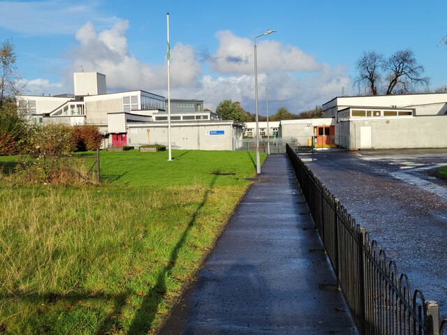
Saint Martin's R.C. Primary School, Renton Saint Martin's R.C. Primary School, at Place of Bonhill in Renton.
Saint Martin's R.C. Primary School, Renton
Saint Martin's R.C. Primary School, at Place of Bonhill in Renton.
Tunnel under A82 This tunnel leads from the Milburn housing estate west up to Milburn or Carman Muir or north along a footpath parallel to the A82 to the Vale of Leven Cemetery.

Images at <a href="https://www.geograph.org.uk/photo/429832">NS3879 : Tunnel under A82</a> and <a href="https://www.geograph.org.uk/photo/429832">NS3879 : Tunnel under A82</a> show the west and east ends. This photo illustrates the length of this unlit pedestrian tunnel.

For those brave enough to wander through at night-time, it is apparently a hang-out for bats.
Tunnel under A82
This tunnel leads from the Milburn housing estate west up to Milburn or Carman Muir or north along a footpath parallel to the A82 to the Vale of Leven Cemetery. Images at NS3879 : Tunnel under A82 and NS3879 : Tunnel under A82 show the west and east ends. This photo illustrates the length of this unlit pedestrian tunnel. For those brave enough to wander through at night-time, it is apparently a hang-out for bats.
Hall beside John Street and Tontine Park See <a href="https://www.geograph.org.uk/photo/5115847">NS3877 : Hall beside John Street</a> for Lairich Rig's description of the hall.
Hall beside John Street and Tontine Park
See NS3877 : Hall beside John Street for Lairich Rig's description of the hall.
Tontine Park Residential street in Renton.
Tontine Park
Residential street in Renton.
Renton Road The B857 looking south.
Renton Road
The B857 looking south.
Renton Road The B857 looking north.
Renton Road
The B857 looking north.
Carpark for Millburn Park, Vale of Leven FC
Alexander Street, Renton
Back Street, Renton
Back Street, Renton
Construction on the Kippen Dairy site, Alexandria The view is from the pavement beside the main road. See <a href="https://www.geograph.org.uk/photo/4732573">NS3980 : Construction on the Kippen Dairy site, Alexandria</a> for another picture.

Compare <a href="https://www.geograph.org.uk/photo/2198016">NS3980 : Creveul Court, Alexandria</a>, taken five years earlier; the area shown in the foreground, snow-covered but free of buildings, is the construction site shown in the present photograph.
Construction on the Kippen Dairy site, Alexandria
The view is from the pavement beside the main road. See NS3980 : Construction on the Kippen Dairy site, Alexandria for another picture. Compare NS3980 : Creveul Court, Alexandria, taken five years earlier; the area shown in the foreground, snow-covered but free of buildings, is the construction site shown in the present photograph.
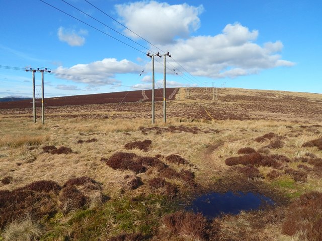
Approaching Bromley Muir This is a view across the lower ground that is between Overton Muir (behind the photographer) and Bromley Muir (ahead).

The darker ground in the left background is fenced off (see <a href="https://www.geograph.org.uk/photo/4313971">NS3680 : Moorland fence</a>, a view in the opposite direction), and those boundaries are shown on the 1:25000 map, as is the course of the power lines.
Approaching Bromley Muir
This is a view across the lower ground that is between Overton Muir (behind the photographer) and Bromley Muir (ahead). The darker ground in the left background is fenced off (see NS3680 : Moorland fence, a view in the opposite direction), and those boundaries are shown on the 1:25000 map, as is the course of the power lines.
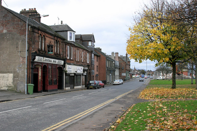
Mitchell Way, Alexandria This is the Bank Street end, during the early stages of redevelopment. For details on the right, compare <a href="https://www.geograph.org.uk/photo/1074064">NS3980 : Mitchell Way, Alexandria</a>.

The nearer buildings on the left were demolished soon afterwards: <a href="https://www.geograph.org.uk/photo/5100419">NS3980 : Mitchell Way, Alexandria</a>.
Mitchell Way, Alexandria
This is the Bank Street end, during the early stages of redevelopment. For details on the right, compare NS3980 : Mitchell Way, Alexandria. The nearer buildings on the left were demolished soon afterwards: NS3980 : Mitchell Way, Alexandria.
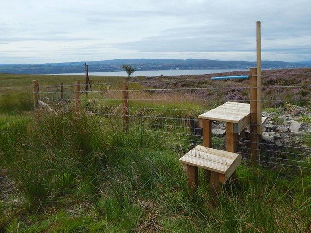
A new stile The 1:25000 map shows the line of the fence, and its sharp turn near the stile. The line of that fence is also the line of a Unitary Authority Boundary, as indicated on the map: West Dunbartonshire is on this side, and Argyll and Bute is on the other.

The Clyde can be seen in the background.

The high ground here at Overtoun Muir and Bromley Muir gives, on clear days, a view to many distant hills.

For example, from the top of Overtoun Muir, about 300 metres SSE of the point from which this picture was taken, and looking towards and over the top of nearby Carman Hill, some distant hills could be seen on the southern skyline, projecting above the nearer ones on the far side of the Clyde: Beninner (<a href="https://www.geograph.org.uk/gridref/NX6097">NX6097</a>, 86 km / 54 miles away) could be seen behind and just to the left of Cairnsmore of Carsphairn (<a href="https://www.geograph.org.uk/gridref/NX5998">NX5998</a>, 85 kms / 53 miles).

To the west, the peaks of Arran are often visible; see <a href="https://www.geograph.org.uk/photo/5061667">NS3581 : Gate on the Stoneymollan Road</a>, taken not far from here. In the present-picture, they are dimly visible on the skyline, directly above the blue sleeve that covers the top of the fence at the stile.

To the east, the Campsie Hills and the more distant Fintry Hills are usually visible; the even more distant Gargunnock and Touch Hills can be seen when the visibility is good: see <a href="https://www.geograph.org.uk/photo/1703819">NS3680 : Bromley Muir trig point</a>. As noted there, another distant hill can often be seen to the south-east: Tinto Hill (<a href="https://www.geograph.org.uk/gridref/NS9534">NS9534</a>), about 75 km away.

To the north, Ben Lomond and many far more distant peaks can be seen.
A new stile
The 1:25000 map shows the line of the fence, and its sharp turn near the stile. The line of that fence is also the line of a Unitary Authority Boundary, as indicated on the map: West Dunbartonshire is on this side, and Argyll and Bute is on the other. The Clyde can be seen in the background. The high ground here at Overtoun Muir and Bromley Muir gives, on clear days, a view to many distant hills. For example, from the top of Overtoun Muir, about 300 metres SSE of the point from which this picture was taken, and looking towards and over the top of nearby Carman Hill, some distant hills could be seen on the southern skyline, projecting above the nearer ones on the far side of the Clyde: Beninner (NX6097, 86 km / 54 miles away) could be seen behind and just to the left of Cairnsmore of Carsphairn (NX5998, 85 kms / 53 miles). To the west, the peaks of Arran are often visible; see NS3581 : Gate on the Stoneymollan Road, taken not far from here. In the present-picture, they are dimly visible on the skyline, directly above the blue sleeve that covers the top of the fence at the stile. To the east, the Campsie Hills and the more distant Fintry Hills are usually visible; the even more distant Gargunnock and Touch Hills can be seen when the visibility is good: see NS3680 : Bromley Muir trig point. As noted there, another distant hill can often be seen to the south-east: Tinto Hill (NS9534), about 75 km away. To the north, Ben Lomond and many far more distant peaks can be seen.
The Pawn Lounge mural The mural had only recently been painted when this picture was taken. It is by Barry the Cat, who had recently painted the nearby <a href="https://www.geograph.org.uk/photo/4946012">NS3979 : Laughing Fox mural</a>.

The building is on Overton Street (part of which is visible in the foreground), which becomes Overton Road beyond the next junction.
The Pawn Lounge mural
The mural had only recently been painted when this picture was taken. It is by Barry the Cat, who had recently painted the nearby NS3979 : Laughing Fox mural. The building is on Overton Street (part of which is visible in the foreground), which becomes Overton Road beyond the next junction.
Construction on the Kippen Dairy site, Alexandria Main Street is in the foreground. The building site is on its eastern side, and this picture shows its southern part.

Bank Street is at the far right, and Alexander Street is at the far left.
Construction on the Kippen Dairy site, Alexandria
Main Street is in the foreground. The building site is on its eastern side, and this picture shows its southern part. Bank Street is at the far right, and Alexander Street is at the far left.
Show me another place!

Carman Reservoir is located at Grid Ref: NS3778 (Lat: 55.973979, Lng: -4.6015579)

Unitary Authority: West Dunbartonshire

Police Authority: Argyll and West Dunbartonshire

What 3 Words

///clumped.watchdogs.backdrop. Near Renton, West Dunbartonshire

Related Wikis

Renton railway station

Renton railway station is a railway station serving the village of Renton, Scotland. The station is managed by ScotRail and is served by its trains on...

Millburn Church

Millburn Church is a ruined former church in Renton, West Dunbartonshire, Scotland. It was built in 1845 for the Free Church of Scotland in the Gothic...

Renton, West Dunbartonshire

Renton (Scottish Gaelic: An Reantan; Scots: The Renton) is a village in West Dunbartonshire, in the west Central Lowlands of Scotland. In the 2001 National...

Vale of Leven

The Vale of Leven (Scottish Gaelic: Magh Leamhna) is an area of West Dunbartonshire, Scotland, in the valley of the River Leven. Historically, it was part...

Nearby Amenities

Located within 500m of 55.973979,-4.6015579
Power: pole
Lat/Long: 55.9751273/-4.6091121
Power: pole
Lat/Long: 55.9740796/-4.608259
Power: pole
Lat/Long: 55.9700114/-4.6043682
Power: pole
Lat/Long: 55.9729594/-4.6073544
Power: pole
Lat/Long: 55.9718108/-4.6064542
Power: pole
Lat/Long: 55.9708076/-4.6056586
Power: pole
Lat/Long: 55.9739993/-4.6085188
Power: pole
Lat/Long: 55.9699751/-4.6047579
Power: pole
Lat/Long: 55.9747881/-4.6091641
Power: pole
Lat/Long: 55.9706664/-4.6058765
Power: pole
Lat/Long: 55.9728442/-4.6075957
Power: pole
Lat/Long: 55.9717158/-4.606706
Parking
Lat/Long: 55.9747393/-4.6052677
Aeroway: parking_position
Lat/Long: 55.9756279/-4.604289
Aeroway: parking_position
Lat/Long: 55.9756481/-4.6042394
Aeroway: parking_position
Lat/Long: 55.975665/-4.6041918
Aeroway: parking_position
Lat/Long: 55.9756868/-4.6041448
Aeroway: parking_position
Lat/Long: 55.9757063/-4.6040979
Aeroway: parking_position
Lat/Long: 55.9757265/-4.604051
Aeroway: parking_position
Lat/Long: 55.9757476/-4.6040107
Aeroway: parking_position
Lat/Long: 55.9757963/-4.6039383
Aeroway: parking_position
Lat/Long: 55.9758316/-4.6039417
Aeroway: parking_position
Lat/Long: 55.9758691/-4.6039604
Aeroway: parking_position
Lat/Long: 55.9758958/-4.6039933
Aeroway: parking_position
Lat/Long: 55.9759239/-4.6040382
Power: tower
Source: Bing
Lat/Long: 55.9697306/-4.6040976
Power: pole
Lat/Long: 55.9769183/-4.5956911
Power: pole
Lat/Long: 55.9761925/-4.5955612
Power: pole
Lat/Long: 55.9755101/-4.5954417
Power: pole
Lat/Long: 55.9747855/-4.5953265
Power: pole
Lat/Long: 55.9743505/-4.5946979
Power: pole
Lat/Long: 55.9738522/-4.5939582
Barrier: cattle_grid
Lat/Long: 55.975943/-4.6003848
The data included in this document is from www.openstreetmap.org. The data is made available under ODbL.

Have you been to Carman Reservoir?

Leave your review of Carman Reservoir below (or comments, questions and feedback).