An Gorm-Loch

Lake, Pool, Pond, Freshwater Marsh in Ross-shire

Scotland

An Gorm-Loch

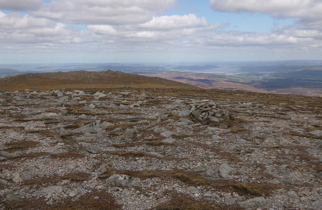
Summit plateau of Carn a' Ghorm-locha Looking towards Sgurr a' Ghlaisein (the rounded summit just left of centre).
Summit plateau of Carn a' Ghorm-locha Credit: Michael Earnshaw

An Gorm-Loch, located in Ross-shire, Scotland, is a picturesque freshwater loch encompassing an area of approximately 10 acres. Situated amidst the stunning natural beauty of the Scottish Highlands, this body of water is a popular tourist attraction for nature enthusiasts and anglers alike.

The loch is characterized by its crystal-clear waters, which are fed by several small streams and springs originating from the surrounding hills. Surrounded by rolling hills and lush greenery, An Gorm-Loch offers a tranquil and idyllic setting for visitors to unwind and connect with nature.

The diverse ecosystem of An Gorm-Loch supports a rich variety of flora and fauna. Water lilies, reeds, and rushes adorn the shallow edges of the loch, providing a habitat for numerous aquatic plants and insects. The loch is also home to various species of fish, including brown trout and perch, making it a popular spot for fishing.

Birdwatchers can delight in the presence of numerous waterfowl species that frequent An Gorm-Loch throughout the year. Mallards, tufted ducks, and common goldeneyes are commonly spotted gliding across the calm waters, while the surrounding wetlands attract waders such as lapwings and curlews.

An Gorm-Loch offers a range of recreational activities for visitors. Anglers can enjoy fishing for trout, while nature enthusiasts can explore the surrounding trails and observe the diverse wildlife. The loch also provides a peaceful setting for picnics and photography.

Overall, An Gorm-Loch in Ross-shire is a captivating freshwater loch that captivates visitors with its natural beauty, abundant wildlife, and serene ambiance.

If you have any feedback on the listing, please let us know in the comments section below.

An Gorm-Loch Images

Images are sourced within 2km of 57.479854/-4.7153852 or Grid Reference NH3746. Thanks to Geograph Open Source API. All images are credited.

Summit plateau of Carn a' Ghorm-locha Looking towards Sgurr a' Ghlaisein (the rounded summit just left of centre).
Summit plateau of Carn a' Ghorm-locha
Looking towards Sgurr a' Ghlaisein (the rounded summit just left of centre).
Burnside Fox Moth Our lunch stop by Allt a' Bhealaich proved a wise choice, this Fox Moth 'fuzzy' caterpillar was a welcome sight!
Burnside Fox Moth
Our lunch stop by Allt a' Bhealaich proved a wise choice, this Fox Moth 'fuzzy' caterpillar was a welcome sight!
Summit, Sgùrr a' Phollain Quite a wide, flat summit on Sgùrr a' Phollain. This small cairn may be the highest point (855m).
Good views towards the Beauly Firth and beyond.
Summit, Sgùrr a' Phollain
Quite a wide, flat summit on Sgùrr a' Phollain. This small cairn may be the highest point (855m). Good views towards the Beauly Firth and beyond.
Ridge to Carn na Gabhalach Looking east along the ridge between Sgùrr a' Phollain and Carn na Gabhalach.

There is a rough path along the ridge, along with a line of old metal fence posts.
Ridge to Carn na Gabhalach
Looking east along the ridge between Sgùrr a' Phollain and Carn na Gabhalach. There is a rough path along the ridge, along with a line of old metal fence posts.
Summit, Carn na Gabhalach A fairly wide, flat summit, at a height of 713m.
A line of old metal fence posts turn a corner at the summit, as does a somewhat indistinct path.
Summit, Carn na Gabhalach
A fairly wide, flat summit, at a height of 713m. A line of old metal fence posts turn a corner at the summit, as does a somewhat indistinct path.
Carn na Gabhalach View of ridge including Beinn a' Bha'ach Ard (l), Sgurr a' Phollain (c) and Carn na Gabhalach (r)
Carn na Gabhalach
View of ridge including Beinn a' Bha'ach Ard (l), Sgurr a' Phollain (c) and Carn na Gabhalach (r)
Drifts on Sgurr a' Phollain summit
Ridge east from Sgùrr a' Phollain The ground drops steeply eastwards from Sgùrr a' Phollain before levelling out and heading towards Carn na Gabhalach. A stalkers' path follows the ridge going down the steepness in zigzags, being lost in peat haggs at the foot of it then becoming clear again along the flat stretch.
Ridge east from Sgùrr a' Phollain
The ground drops steeply eastwards from Sgùrr a' Phollain before levelling out and heading towards Carn na Gabhalach. A stalkers' path follows the ridge going down the steepness in zigzags, being lost in peat haggs at the foot of it then becoming clear again along the flat stretch.
Summit rocks of Sgùrr a' Phollain Sgùrr a' Phollain is a subsidiary top of the Corbett, Beinn a' Bhàthaich Àrd. The summit rocks are seen here, the final rise there being a fine carpet of moss with lichen. The actual highest point is possibly a short distance beyond the mountain walker where there's a small cairn on a flat barren area.
Summit rocks of Sgùrr a' Phollain
Sgùrr a' Phollain is a subsidiary top of the Corbett, Beinn a' Bhàthaich Àrd. The summit rocks are seen here, the final rise there being a fine carpet of moss with lichen. The actual highest point is possibly a short distance beyond the mountain walker where there's a small cairn on a flat barren area.
Snow on Sgurr a' Phollaire in August Just to the right of the summit of Sgurr a' Phollaire, probably in NH3744, is a small patch of snow, on a south-facing slope in early August. It has been the poorest summer in Scotland for 30 years. Sgurr a ' Phollaire is really just a subsidiary peak of Beinn a' Bhataich Ard in NH3643, and to the left in the photo.
Snow on Sgurr a' Phollaire in August
Just to the right of the summit of Sgurr a' Phollaire, probably in NH3744, is a small patch of snow, on a south-facing slope in early August. It has been the poorest summer in Scotland for 30 years. Sgurr a ' Phollaire is really just a subsidiary peak of Beinn a' Bhataich Ard in NH3643, and to the left in the photo.
Waterfall on the Allt a'Bhealaich
Allt a'Bhealaich The Allt a'Bhealaich and a minor tributary merge, and continue onwards towards Orrin Reservoir.
Allt a'Bhealaich
The Allt a'Bhealaich and a minor tributary merge, and continue onwards towards Orrin Reservoir.
East ridge of Sgurr a'Phollain Descending the east ridge of Sgurr a'Phollain on a freezing but sunny day. A sea of clouds fills all the glens including covering Inverness which would normally be visible from here.
East ridge of Sgurr a'Phollain
Descending the east ridge of Sgurr a'Phollain on a freezing but sunny day. A sea of clouds fills all the glens including covering Inverness which would normally be visible from here.
Sgurr a' Pollain A superb beginning to the New Year of 2009. The vista of the Cromarty and Beauly Firths with the Black Isle in between them.
Sgurr a' Pollain
A superb beginning to the New Year of 2009. The vista of the Cromarty and Beauly Firths with the Black Isle in between them.
Cairn on Sgurr a'Phollain
Show me another place!

An Gorm-Loch is located at Grid Ref: NH3746 (Lat: 57.479854, Lng: -4.7153852)

Unitary Authority: Highland

Police Authority: Highlands and Islands

What 3 Words

///narrow.handle.dressings. Near Cannich, Highland

Nearby Locations

An Gorm-Loch

Related Wikis

Beinn a' Bhathaich Àrd

Beinn a' Bhathaich Àrd is mountain on the northern side of Glen Strathfarrar, in the Highlands of Scotland. It is situated at the eastern end of the glen...

Inchmore, Strathfarrar

Inchmore is a small hamlet at the foot of Glen Strathfarrar, in Inverness-shire in the Scottish Highlands of Scotland. It is situated 1 km (0.62 mi) north...

Struy

Struy (Scottish Gaelic: An t-Srùigh or Scottish Gaelic: Sruidh) is a small village at the end of Glen Strathfarrar, about 15 km south-west of Beauly in...

River Beauly

The River Beauly (Scottish Gaelic: Abhainn nam Manach, pronounced [ˈavɪɲ nə ˈmanəx]) is a river in the Scottish Highlands, about 15 km west of the city...

Have you been to An Gorm-Loch?

Leave your review of An Gorm-Loch below (or comments, questions and feedback).