Black Loch

Lake, Pool, Pond, Freshwater Marsh in Wigtownshire

Scotland

Black Loch

Forest near Barshalloch Hill Trees of varying ages and stages on the lower slopes of Barshalloch Hill.
Forest near Barshalloch Hill Credit: Mary and Angus Hogg

Black Loch is a freshwater loch located in Wigtownshire, Scotland. It is a relatively small body of water, covering an area of approximately 15 hectares. The loch is nestled within a picturesque landscape, surrounded by rolling hills and dense vegetation, providing a serene and tranquil atmosphere.

The water in Black Loch is clear and still, reflecting the stunning natural scenery that surrounds it. The loch is relatively shallow, with an average depth of around 3 meters, and its waters are primarily fed by rainfall and small streams that flow into it.

The vegetation around Black Loch is diverse and lush, consisting of reeds, rushes, and various aquatic plants. This rich vegetation provides a valuable habitat for a wide range of wildlife, including numerous bird species, such as swans, herons, and ducks. The loch is particularly popular among birdwatchers, as it attracts a significant number of migratory birds during the breeding season.

Fishing is also a popular activity in Black Loch, with anglers coming to enjoy the abundance of fish species, including pike, perch, and roach. The loch is well-known for its healthy fish population, making it an ideal spot for both recreational and competitive fishing.

Visitors to Black Loch can also explore the surrounding area, which offers various walking trails and picnic spots. The tranquil and scenic beauty of the loch, combined with its diverse wildlife and recreational opportunities, makes Black Loch a popular destination for nature enthusiasts and those seeking a peaceful retreat.

If you have any feedback on the listing, please let us know in the comments section below.

Black Loch Images

Images are sourced within 2km of 55.046989/-4.6325171 or Grid Reference NX3175. Thanks to Geograph Open Source API. All images are credited.
Forest near Barshalloch Hill Trees of varying ages and stages on the lower slopes of Barshalloch Hill.
Forest near Barshalloch Hill
Trees of varying ages and stages on the lower slopes of Barshalloch Hill.
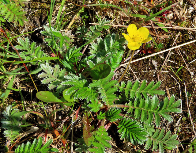
Tormentil This little flower could be mistaken for a buttercup but its 4-petalled flower defines it as Tormentil (Potentilla erecta).  One of many yellow spring flowers commonly found along our footpaths and tracks.
Tormentil
This little flower could be mistaken for a buttercup but its 4-petalled flower defines it as Tormentil (Potentilla erecta). One of many yellow spring flowers commonly found along our footpaths and tracks.
Common Silverweed The Common Silverweed (Argentina anserina) is a low-growing plant that spreads out easily to cover large areas.  Its name comes from the silvery underside of the leaves. In the olden days, Silverweed was believed to be a protection against witches. One of many yellow spring flowers commonly found along our footpaths and tracks.
Common Silverweed
The Common Silverweed (Argentina anserina) is a low-growing plant that spreads out easily to cover large areas. Its name comes from the silvery underside of the leaves. In the olden days, Silverweed was believed to be a protection against witches. One of many yellow spring flowers commonly found along our footpaths and tracks.
Coltsfoot flowers The bright yellow coltsfoot (Tussilago farfara) can be mistaken for a dandelion. These were growing on the forest track but the dry spring weather had kept them very small. One of many yellow spring flowers commonly found along our footpaths and tracks.
Coltsfoot flowers
The bright yellow coltsfoot (Tussilago farfara) can be mistaken for a dandelion. These were growing on the forest track but the dry spring weather had kept them very small. One of many yellow spring flowers commonly found along our footpaths and tracks.
Frog Spit on a plantain The cluster of frothy bubbles was produced by a froghopper insect.
Frog Spit on a plantain
The cluster of frothy bubbles was produced by a froghopper insect.
An overgrown forest track It’s a long time since this part of the track was used.
An overgrown forest track
It’s a long time since this part of the track was used.
Dalnaw view The farm lies on high ground well above the level of the surrounding boggy area.
Dalnaw view
The farm lies on high ground well above the level of the surrounding boggy area.
Towards Dalnaw The minor road skirts the forest and leads to two remote farms.
Towards Dalnaw
The minor road skirts the forest and leads to two remote farms.
A forest track near Barjarg The road on the left gives access to Barjarg and Dalnaw while the track on the right continues into the forest.
A forest track near Barjarg
The road on the left gives access to Barjarg and Dalnaw while the track on the right continues into the forest.
Forest road The road gives access to a large area on Barjarg Hill, managed by Tilhill Forestry.
Forest road
The road gives access to a large area on Barjarg Hill, managed by Tilhill Forestry.
Swirls of cirrus The high-level wind had produced some spectacular swirls of goat’s hair cloud above the forest near Barwinnock.
Swirls of cirrus
The high-level wind had produced some spectacular swirls of goat’s hair cloud above the forest near Barwinnock.
Towards Barshalloch The forest continues to Barshalloch Hill and beyond.
Towards Barshalloch
The forest continues to Barshalloch Hill and beyond.
Barwinnock view The low ground on the left is boggy, being fed by a slow-moving watercourse that flows into the Carrick Burn a little further downstream.
Barwinnock view
The low ground on the left is boggy, being fed by a slow-moving watercourse that flows into the Carrick Burn a little further downstream.
Approaching Barwinnock The steading lies on the other side of the cattle grid on this minor dead-end road.
Approaching Barwinnock
The steading lies on the other side of the cattle grid on this minor dead-end road.
The Southern Upland Way near Hill of Ochiltree
The Southern Upland Way near Top of the Fell
The Southern Upland Way near Butter Cairn
Show me another place!

Black Loch is located at Grid Ref: NX3175 (Lat: 55.046989, Lng: -4.6325171)

Unitary Authority: Dumfries and Galloway

Police Authority: Dumfries and Galloway

What 3 Words

///composers.chum.still. Near Newton Stewart, Dumfries & Galloway

Nearby Locations

Black Loch Castle Hill

Related Wikis

Loch Dornal

Loch Dornal is an irregular shaped, shallow, freshwater loch in south Ayrshire, in the Southern Uplands of Scotland. It lies approximately eight miles...

Bargrennan

Bargrennan (Scottish Gaelic: Bar Grianain, meaning height of the summer house or sunny spot) is a village in Dumfries and Galloway, in the south west of...

Cairnderry chambered cairn

Cairnderry chambered cairn is a chambered cairn in Dumfries and Galloway. It is a Bargrennan cairn, a type of Neolithic or early Bronze Age monument only...

Glentrool

Glentrool is a collection of mountain biking routes through the heart of Galloway in southwest Scotland. The mountain bike routes are part of the 7Stanes...

Wood of Cree

Wood of Cree is a nature reserve in Dumfries and Galloway, Scotland. Located approximately 4 miles (6.4 km) north north-west of Newton Stewart, it is managed...

Kilgallioch

Kilgallioch Wind Farm is a 96 turbine wind farm in South Ayrshire, Scotland with a total capacity of up to 239 megawatts (MW). Consent granted by the Scottish...

Glen Trool

Glen Trool (Scottish Gaelic: Gleann an t-Sruthail) is a glen in the Southern Uplands, Galloway, Scotland. It contains Loch Trool which is fed by several...

Nearby Amenities

Located within 500m of 55.046989,-4.6325171
Ele: 127
Natural: peak
Lat/Long: 55.0433627/-4.6333124
The data included in this document is from www.openstreetmap.org. The data is made available under ODbL.

Have you been to Black Loch?

Leave your review of Black Loch below (or comments, questions and feedback).