Black Loch

Lake, Pool, Pond, Freshwater Marsh in Ayrshire

Scotland

Black Loch

Ballochmorrie Farm
Ballochmorrie Farm Credit: Iain Thompson

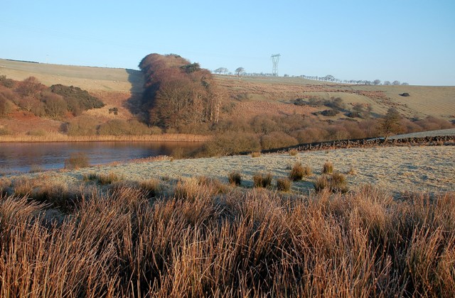
Black Loch is a picturesque freshwater loch located in Ayrshire, Scotland. It is situated within the Black Loch Wood Nature Reserve and covers an area of approximately 20 hectares. The loch is surrounded by dense woodlands, creating a serene and tranquil environment.

The water in Black Loch is clear and of high quality, being fed by natural springs and rainwater runoff. The depth of the loch varies, with some areas reaching up to 7 meters in depth. The water level is relatively stable throughout the year, being sustained by the natural water sources.

The loch is home to a diverse range of flora and fauna, making it a popular spot for nature enthusiasts and birdwatchers. The woodlands surrounding the loch are filled with oak, birch, and pine trees, providing a habitat for various wildlife species. Bird species such as great crested grebes, tufted ducks, and herons can be spotted around the loch, making it a haven for birdwatching enthusiasts.

Fishing is a popular activity in Black Loch, with anglers frequently visiting to catch brown trout and pike. The calm and peaceful atmosphere of the loch makes it an ideal spot for fishing.

Overall, Black Loch in Ayrshire offers a beautiful natural setting with its clear waters, surrounding woodlands, and diverse wildlife. Whether you are an avid birdwatcher, angler, or simply looking for a peaceful retreat, Black Loch is a destination worth exploring.

If you have any feedback on the listing, please let us know in the comments section below.

Black Loch Images

Images are sourced within 2km of 55.1091/-4.8279565 or Grid Reference NX1983. Thanks to Geograph Open Source API. All images are credited.

Ballochmorrie Farm
Ballochmorrie Farm
Field Beside Ballochmorrie Farm
Ballochmorrie Farm Viewed from the roadside in the next square on a frosty January morning.
Ballochmorrie Farm
Viewed from the roadside in the next square on a frosty January morning.
Towards Ballochmorrie Looking across pastureland towards Ballochmorrie Farm, in the next square, on a frosty January morning.
Towards Ballochmorrie
Looking across pastureland towards Ballochmorrie Farm, in the next square, on a frosty January morning.
Loch Lig The north-eastern end of the loch, viewed on a fine January morning.
Loch Lig
The north-eastern end of the loch, viewed on a fine January morning.
Blackpark Ruin The ruined cottage at Blackpark, viewed on a fine January morning with 4 days' unbroken frost on the ground.
Blackpark Ruin
The ruined cottage at Blackpark, viewed on a fine January morning with 4 days' unbroken frost on the ground.
Loch Lig View Looking towards Loch Lig and, in the next square, Craigbrae from the pastureland on the south side of the Lig valley.  The loch was partly covered with ice.  In the background are the distinctive pylons of the Scotland to Northern Ireland electricity Interconnector.
Loch Lig View
Looking towards Loch Lig and, in the next square, Craigbrae from the pastureland on the south side of the Lig valley. The loch was partly covered with ice. In the background are the distinctive pylons of the Scotland to Northern Ireland electricity Interconnector.
Down The Dyke Looking north-east from the pastureland between the Blackpark ruin and Loch Lig.  Viewed on a fine January morning after four days of unbroken frost.
Down The Dyke
Looking north-east from the pastureland between the Blackpark ruin and Loch Lig. Viewed on a fine January morning after four days of unbroken frost.
The Lig Valley Looking up the valley from the southern slopes near Loch Lig.
The Lig Valley
Looking up the valley from the southern slopes near Loch Lig.
Winter Sheep Sheep on the pastureland above Loch Lig, viewed on a fine but chilly January morning.
Winter Sheep
Sheep on the pastureland above Loch Lig, viewed on a fine but chilly January morning.
Frosty Track A farm track to the north of Loch Lig, encrusted with 4 days' unbroken frost.
Frosty Track
A farm track to the north of Loch Lig, encrusted with 4 days' unbroken frost.
Frosted Grass Beautiful crystalline patterns produced by four nights and days of frost.
Frosted Grass
Beautiful crystalline patterns produced by four nights and days of frost.
Frozen Track Although on the sunny side of the Lig valley, the water on this track is still frozen solid.  The trees in the background are at the top end of the small shelter belt, in the same square.
Frozen Track
Although on the sunny side of the Lig valley, the water on this track is still frozen solid. The trees in the background are at the top end of the small shelter belt, in the same square.
The Lig Valley Looking up the valley on a chilly January morning. The block of trees on the left is in the next square.
The Lig Valley
Looking up the valley on a chilly January morning. The block of trees on the left is in the next square.
Pasture Above Loch Lig Good grazing land above Loch Lig, viewed on a frosty January morning.  The block of trees is in the next square.
Pasture Above Loch Lig
Good grazing land above Loch Lig, viewed on a frosty January morning. The block of trees is in the next square.
Along The Fence Looking along the fence line to the south of Loch Lig towards the block of trees in the next square.
Along The Fence
Looking along the fence line to the south of Loch Lig towards the block of trees in the next square.
We Don't Feel The Cold! A small group of well-insulated sheep on frosty grazing land above Loch Lig.
We Don't Feel The Cold!
A small group of well-insulated sheep on frosty grazing land above Loch Lig.
The Burn of Lig This burn flows through Loch Lig to join the Duisk River a few miles north-west from Barrhill.  The water level was unusually low after a long spell of dry spring weather.
The Burn of Lig
This burn flows through Loch Lig to join the Duisk River a few miles north-west from Barrhill. The water level was unusually low after a long spell of dry spring weather.
Show me another place!

Black Loch is located at Grid Ref: NX1983 (Lat: 55.1091, Lng: -4.8279565)

Unitary Authority: South Ayrshire

Police Authority: Ayrshire

What 3 Words

///armrests.mothering.heaven. Near Girvan, South Ayrshire

Nearby Locations

Black Loch

Related Wikis

Barrhill railway station

Barrhill railway station is a railway station serving the village of Barrhill, South Ayrshire, Scotland. The station is managed by ScotRail and is on the...

Barrhill, South Ayrshire

Barrhill (Scots: Baurhill) is a village in South Ayrshire, Scotland with a population of approximately 400 in 2001.While the surrounding area is predominantly...

Pinwherry

Pinwherry is a hamlet in the civil parish of Colmonell, in the council area of South Ayrshire, Scotland. It is 8 miles south of Girvan. In 1961 it had...

Pinwherry railway station

Pinwherry railway station served the village of Pinwherry, South Ayrshire, Scotland from 1887 to 1965 on the Girvan and Portpatrick Junction Railway....

Nearby Amenities

Located within 500m of 55.1091,-4.8279565
Power: pole
Lat/Long: 55.1091801/-4.8353509
Power: pole
Lat/Long: 55.1085089/-4.8341916
Power: pole
Lat/Long: 55.108412/-4.8330181
Power: pole
Lat/Long: 55.1082963/-4.8316658
Power: pole
Lat/Long: 55.1081901/-4.8303653
Power: pole
Lat/Long: 55.1080717/-4.8290931
Power: pole
Lat/Long: 55.1079533/-4.8277832
Power: pole
Lat/Long: 55.1078403/-4.8264638
Power: pole
Lat/Long: 55.1073627/-4.8254362
Power: pole
Lat/Long: 55.1068273/-4.8243167
Power: pole
Lat/Long: 55.1063349/-4.8232914
The data included in this document is from www.openstreetmap.org. The data is made available under ODbL.

Have you been to Black Loch?

Leave your review of Black Loch below (or comments, questions and feedback).