Alit Glac Odhar

Lake, Pool, Pond, Freshwater Marsh in Ross-shire

Scotland

Alit Glac Odhar

Moorland above Inverlael Forest A good view towards An Teallach and the Fisherfield munros
Moorland above Inverlael Forest Credit: Andrew Spenceley

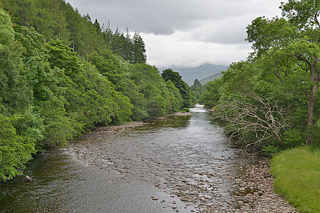
Alit Glac Odhar, located in Ross-shire, Scotland, is a picturesque freshwater marsh that offers a tranquil and serene setting for nature lovers. Spanning over a vast area, this marsh is nestled amidst stunning natural landscapes, making it a popular destination for tourists and locals alike.

The marsh is primarily characterized by its calm and still waters, which form a beautiful lake-like appearance. The water in Alit Glac Odhar is sourced from various streams and rainfall, contributing to its crystal-clear quality. This clarity also allows for an abundance of aquatic vegetation to thrive, creating a vibrant ecosystem within the marsh.

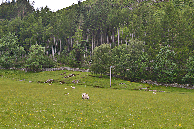
The marsh is home to a diverse range of flora and fauna. Visitors can spot a variety of bird species such as herons, ducks, and swans, which flock to the marsh for its rich food sources and nesting opportunities. Additionally, the surrounding vegetation includes lily pads, reeds, and other water-loving plants, providing a habitat for amphibians, insects, and small mammals.

Alit Glac Odhar offers a range of recreational activities for nature enthusiasts. Fishing is a popular pastime here, with anglers being drawn to the marsh in search of a catch. The marsh is known for its healthy population of fish, including trout and perch, providing an excellent opportunity for anglers to test their skills.

The marsh is also a haven for photographers and artists, with its breathtaking scenery and abundant wildlife providing endless inspiration. Walking trails and viewpoints are available, allowing visitors to explore and appreciate the marsh's beauty while being mindful of conservation efforts to protect this fragile ecosystem.

In conclusion, Alit Glac Odhar in Ross-shire is a captivating freshwater marsh that offers a peaceful retreat for those seeking a connection with nature. Its serene waters, diverse wildlife, and stunning landscapes make it a must-visit destination for anyone looking to escape the hustle and bustle of everyday life.

If you have any feedback on the listing, please let us know in the comments section below.

Alit Glac Odhar Images

Images are sourced within 2km of 57.793393/-5.0475011 or Grid Reference NH1882. Thanks to Geograph Open Source API. All images are credited.

Moorland above Inverlael Forest A good view towards An Teallach and the Fisherfield munros
Moorland above Inverlael Forest
A good view towards An Teallach and the Fisherfield munros
Moorland above Lael Forest In the distance can be seen the burning hillside of the western Fannich, due to the dry conditions of early May.
Moorland above Lael Forest
In the distance can be seen the burning hillside of the western Fannich, due to the dry conditions of early May.
Allt na h-Ighine Looking down the Allt na h-Ighine with An Teallach in the distance.
Allt na h-Ighine
Looking down the Allt na h-Ighine with An Teallach in the distance.
View down Strath More Photo taken from the viewpoint on the A832. The River Broom drains into the distant Loch Broom.
View down Strath More
Photo taken from the viewpoint on the A832. The River Broom drains into the distant Loch Broom.
The River Broom at Inverbroom Bridge
Field and forestry near Auchlunachan
Auchindrean Bridge A neat bow-string girder construction across the River Broom.
Auchindrean Bridge
A neat bow-string girder construction across the River Broom.
Picnic area, Braemore Wood
Noticeboard and start of walk, Braemore Wood
Forestry entrance near Glackour
The A835 near Glackour
The A835 near Foich Lodge
Entrance to Foich Lodge on the A835
The A835 approaching the Letters turn
Auchindrean Bridge Just off the A835 road, this bridge crosses the River Broom, carrying the estate road to Auchindrean Farm.

This bridge was built circa 1870, to designs by Sir John Fowler, who later designed the Forth Bridge. It is a lenticular-truss, wrought-iron bridge, said to be unique in Scotland. It is a Category A listed building. <span class="nowrap"><a title="http://portal.historicenvironment.scot/designation/LB7754" rel="nofollow ugc noopener" href="http://portal.historicenvironment.scot/designation/LB7754">Link</a><img style="margin-left:2px;" alt="External link" title="External link - shift click to open in new window" src="https://s1.geograph.org.uk/img/external.png" width="10" height="10"/></span>
Auchindrean Bridge
Just off the A835 road, this bridge crosses the River Broom, carrying the estate road to Auchindrean Farm. This bridge was built circa 1870, to designs by Sir John Fowler, who later designed the Forth Bridge. It is a lenticular-truss, wrought-iron bridge, said to be unique in Scotland. It is a Category A listed building. LinkExternal link
Waterfall  on  the  Altnah-gie  Lael  Forest  Garden Lael Forest is alongside the A835 good paths and two off road car parks, one each end. Over 200 different trees and shrubs
Waterfall on the Altnah-gie Lael Forest Garden
Lael Forest is alongside the A835 good paths and two off road car parks, one each end. Over 200 different trees and shrubs
Information  board  for  Lael  Forest  Garden
Information board for Lael Forest Garden
Checking  is  the  easy  bit, worry  if  you  find  some
Checking is the easy bit, worry if you find some
Show me another place!

Alit Glac Odhar is located at Grid Ref: NH1882 (Lat: 57.793393, Lng: -5.0475011)

Unitary Authority: Highland

Police Authority: Highlands and Islands

What 3 Words

///revives.wiring.absorb. Near Ullapool, Highland

Related Wikis

Auchindrean

Auchindrean (Scottish Gaelic: Achadh an Dreaghainn) is a small settlement close to the southern end of Loch Broom in Wester Ross, in the Highland council...

Ross-shire

Ross-shire (; Scottish Gaelic: Siorrachd Rois) is a historic county in the Scottish Highlands. The county borders Sutherland to the north and Inverness...

Inverlael

Inverlael is a hamlet on the southern tip of Loch Broom in Ross-shire in the Highland council area in Scotland. It is located on the A835 main road 6 miles...

Beinn Enaiglair

Beinn Enaiglair (890 m) is a mountain in Wester Ross, Scotland. It lies in the Northwest Highlands. An outlier of the Beinn Dearg range, it is a mountain...

Nearby Amenities

Located within 500m of 57.793393,-5.0475011
Townhall
Braemore Hall
Lat/Long: 57.7919216/-5.0464904
Power: pole
Lat/Long: 57.7893795/-5.0455704
Power: pole
Lat/Long: 57.7902945/-5.0465441
Power: pole
Lat/Long: 57.7909994/-5.0473273
Power: pole
Lat/Long: 57.7912867/-5.0481534
Power: pole
Lat/Long: 57.7915712/-5.0490117
Power: pole
Lat/Long: 57.7915169/-5.0500229
Power: pole
Lat/Long: 57.7920344/-5.0511387
Power: pole
Lat/Long: 57.7923632/-5.0519058
Power: pole
Lat/Long: 57.7931295/-5.0543788
Power: pole
Lat/Long: 57.7925274/-5.0495074
Power: pole
Lat/Long: 57.7933211/-5.0499887
Power: pole
Lat/Long: 57.7941595/-5.0505539
Power: pole
Lat/Long: 57.794968/-5.0510889
Power: pole
Lat/Long: 57.7958269/-5.0516541
Power: pole
Lat/Long: 57.7967694/-5.0522557
Power: pole
Lat/Long: 57.7915619/-5.0482159
Power: pole
Lat/Long: 57.7917578/-5.0482675
Power: pole
Lat/Long: 57.7920556/-5.0473284
Power: pole
Lat/Long: 57.7923213/-5.0464496
Power: pole
Lat/Long: 57.7930543/-5.047206
Power: pole
Lat/Long: 57.7926717/-5.0467998
Power: pole
Lat/Long: 57.7919949/-5.0460585
Power: pole
Lat/Long: 57.7915631/-5.0455234
Power: pole
Lat/Long: 57.7912126/-5.0451065
The data included in this document is from www.openstreetmap.org. The data is made available under ODbL.

Have you been to Alit Glac Odhar?

Leave your review of Alit Glac Odhar below (or comments, questions and feedback).