Allt Creagan nam Gobhar

Lake, Pool, Pond, Freshwater Marsh in Ross-shire

Scotland

Allt Creagan nam Gobhar

Valley of the R Meig from path up Coire Mhoraigein
Valley of the R Meig from path up Coire Mhoraigein Credit: Colin Park

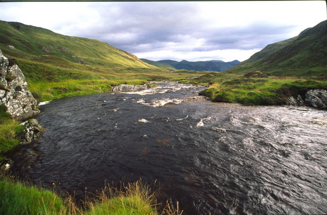
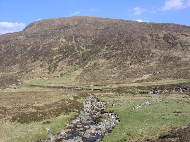
Allt Creagan nam Gobhar is a small freshwater marsh located in Ross-shire, Scotland. It is situated near a cluster of hills and is fed by a small stream called Allt Creagan nam Gobhar, which flows into the marsh, creating a tranquil atmosphere.

The marsh is relatively small in size, covering an area of approximately 2 acres. It is surrounded by lush vegetation, including grasses, sedges, and reeds, which provide a habitat for a diverse range of plant and animal species.

The water in Allt Creagan nam Gobhar is calm and clear, allowing for optimal visibility of the underwater ecosystem. This, in turn, attracts a variety of aquatic life, such as fish, amphibians, and invertebrates.

The marsh is also a popular spot for birdwatching enthusiasts, as it serves as a resting place for various species of birds during their migrations. Visitors can often spot waterfowl, wading birds, and even rare species that are attracted to the rich food sources and shelter provided by the marsh.

Access to Allt Creagan nam Gobhar is relatively easy, with a small path leading visitors to the marsh. The site is well-maintained, with wooden platforms and boardwalks allowing visitors to explore the marsh without damaging the delicate ecosystem.

Overall, Allt Creagan nam Gobhar is a serene and biodiverse freshwater marsh, offering visitors a chance to connect with nature and observe the beauty of the Scottish countryside.

If you have any feedback on the listing, please let us know in the comments section below.

Allt Creagan nam Gobhar Images

Images are sourced within 2km of 57.502581/-5.0316833 or Grid Reference NH1849. Thanks to Geograph Open Source API. All images are credited.

Valley of the R Meig from path up Coire Mhoraigein
Vague ATV track in Gleann Fhiodhaig Looking towards Maoile Lunndaidh
Vague ATV track in Gleann Fhiodhaig
Looking towards Maoile Lunndaidh
Allt Coire Mhòraigein A waterfall near Scardroy, below Meall Innes na Sìne.
Allt Coire Mhòraigein
A waterfall near Scardroy, below Meall Innes na Sìne.
Coire Mhòraigein Leading to Drochaid Coire Mhadaidh, a pass between Bac an Eich and Sgùrr Coire nan Eun. Trees survive in inaccessible parts of steep banks.
Coire Mhòraigein
Leading to Drochaid Coire Mhadaidh, a pass between Bac an Eich and Sgùrr Coire nan Eun. Trees survive in inaccessible parts of steep banks.
Allt Coire Mhòraigein An overnight stop between Achnasheen and Cannich. View from the top of a small waterfall.
Allt Coire Mhòraigein
An overnight stop between Achnasheen and Cannich. View from the top of a small waterfall.
View up the River Meig Valley
View down River Meig The river was in spate after a night of heavy rain - making it much more difficult to cross. Little did we know this was just the beginning !
View down River Meig
The river was in spate after a night of heavy rain - making it much more difficult to cross. Little did we know this was just the beginning !
Corrievuic Looking upstream from between Scardroy and Corriefeol
Corrievuic
Looking upstream from between Scardroy and Corriefeol
Allt na Criche burn flowing downhill to the River Meig The Allt na Criche burn flows down to the River Meig in Gleann Fhiodhaig. The burn is one of many that crosses the path/track from Scardroy to Craig. It is the biggest burn to cross the route and can be difficult to ford when it is in spate. 
Meall Innes na Sine is in the background.
Allt na Criche burn flowing downhill to the River Meig
The Allt na Criche burn flows down to the River Meig in Gleann Fhiodhaig. The burn is one of many that crosses the path/track from Scardroy to Craig. It is the biggest burn to cross the route and can be difficult to ford when it is in spate. Meall Innes na Sine is in the background.
On the path into Coire Mhoraigein
Coire Mhoraigein
Coire Mhoraigein
Meall Innis na Sine From the summit of Meall Innis na Sine.
Meall Innis na Sine
From the summit of Meall Innis na Sine.
From the summit of Meall Innis na Sine This is the superb view up Gleann Fhiodhaig (River Meig valley).
From the summit of Meall Innis na Sine
This is the superb view up Gleann Fhiodhaig (River Meig valley).
Allt Coire Mhòraigein A steep incident in the burn as it meets the flood plain in upper Strath Conon.
Allt Coire Mhòraigein
A steep incident in the burn as it meets the flood plain in upper Strath Conon.
View down River Meig valley past the Moraines The path takes us up over the moraines and this is the view back down the valley
View down River Meig valley past the Moraines
The path takes us up over the moraines and this is the view back down the valley
Island on River Meig The island, on the right hand side of the foreground, is in the middle of the River Meig, Gleann Fhiodhaig. Across the river, the Coire Mhoraigein flows down to the River Meig.
Island on River Meig
The island, on the right hand side of the foreground, is in the middle of the River Meig, Gleann Fhiodhaig. Across the river, the Coire Mhoraigein flows down to the River Meig.
Track above Corrievuic The track leads to Corrievuic, Strathconon, which is half a mile further east.
Track above Corrievuic
The track leads to Corrievuic, Strathconon, which is half a mile further east.
Hillside above Coir'a'Bhuic The hill on the right is Creag Coir'a'Bhuic
Hillside above Coir'a'Bhuic
The hill on the right is Creag Coir'a'Bhuic
Show me another place!

Allt Creagan nam Gobhar is located at Grid Ref: NH1849 (Lat: 57.502581, Lng: -5.0316833)

Unitary Authority: Highland

Police Authority: Highlands and Islands

What 3 Words

///surreal.passports.protected. Near Achnasheen, Highland

Related Wikis

Northwest Highlands

The Northwest Highlands are located in the northern third of Scotland that is separated from the Grampian Mountains by the Great Glen (Glen More). The...

Highland (council area)

Highland (Scottish Gaelic: Gàidhealtachd, pronounced [ˈkɛːəl̪ˠt̪əxk]; Scots: Hieland) is a council area in the Scottish Highlands and is the largest local...

Bac an Eich

Bac an Eich (849 m) is a mountain in Ross and Cromarty in the Northwest Highlands of Scotland. A very remote mountain, it lies at the head of Strathconan...

Maoile Lunndaidh

Maoile Lunndaidh or Maoil Lunndaidh is a Scottish mountain situated 13 km south of Achnasheen in the Ross and Cromarty district of the Highland council...

Nearby Amenities

Located within 500m of 57.502581,-5.0316833
Ford: yes
Lat/Long: 57.5025561/-5.0314553
The data included in this document is from www.openstreetmap.org. The data is made available under ODbL.

Have you been to Allt Creagan nam Gobhar?

Leave your review of Allt Creagan nam Gobhar below (or comments, questions and feedback).