Lochan an Fhithich

Lake, Pool, Pond, Freshwater Marsh in Inverness-shire

Scotland

Lochan an Fhithich

Bend in the Allt an Fhithich, Inverness-shire Looking towards Carn Dubh and Sgùrr Chòinnich.
Bend in the Allt an Fhithich, Inverness-shire Credit: Claire Pegrum

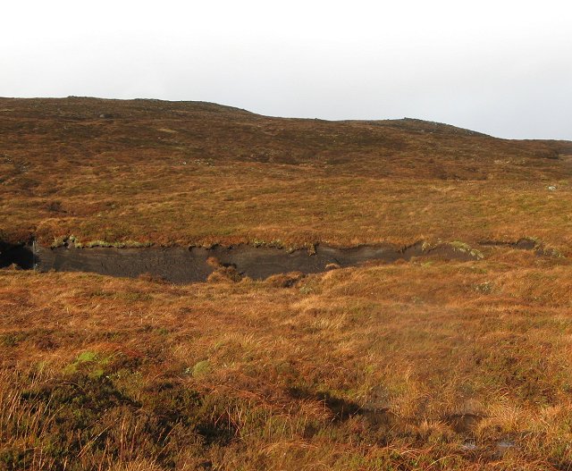
Lochan an Fhithich, located in Inverness-shire, Scotland, is a picturesque freshwater body that can be classified as a lake, pool, pond, and freshwater marsh. Nestled amidst the stunning Scottish Highlands, it offers a serene and tranquil setting for nature enthusiasts and visitors seeking a peaceful retreat.

Covering a relatively small area, Lochan an Fhithich is surrounded by lush greenery and rolling hills, creating a breathtaking backdrop. The crystal-clear waters of the lochan reflect the beauty of the surrounding landscape, making it a popular spot for photography and painting enthusiasts.

The lochan is home to diverse flora and fauna, making it an important ecological site. The freshwater marshes surrounding the lochan provide a habitat for various plant species like reeds, sedges, and water lilies. These marshes also attract a wide range of bird species, including ducks, geese, and waders, which thrive in this wetland environment.

Visitors can explore Lochan an Fhithich by following the well-maintained walking trails that encircle the lochan. The trails offer stunning panoramic views and allow visitors to observe the local wildlife up close. Fishing enthusiasts can also take advantage of the lochan's abundant fish population, with species such as wild brown trout and perch being commonly caught.

Overall, Lochan an Fhithich is a haven of natural beauty and biodiversity. Its combination of a small lake, pool, pond, and freshwater marsh makes it a unique and captivating destination for those seeking a peaceful and immersive experience in the Scottish Highlands.

If you have any feedback on the listing, please let us know in the comments section below.

Lochan an Fhithich Images

Images are sourced within 2km of 57.007843/-5.0695539 or Grid Reference NN1394. Thanks to Geograph Open Source API. All images are credited.

Bend in the Allt an Fhithich, Inverness-shire Looking towards Carn Dubh and Sgùrr Chòinnich.
Bend in the Allt an Fhithich, Inverness-shire
Looking towards Carn Dubh and Sgùrr Chòinnich.
The Allt an Fhithich, Inverness-shire
Geal Charn View west from the top of Geal Charn - the foreground is in the grid square
Geal Charn
View west from the top of Geal Charn - the foreground is in the grid square
Sgurr Chòinich Looking up the gentle southern slopes of Sgurr Chòinich. The summit area is finally coming into view.
Sgurr Chòinich
Looking up the gentle southern slopes of Sgurr Chòinich. The summit area is finally coming into view.
Summit, Sgurr Chòinich Rocky summit (749m) on the edge of a steep north face. Loch Garry in the distance.
Summit, Sgurr Chòinich
Rocky summit (749m) on the edge of a steep north face. Loch Garry in the distance.
Sgurr Chòinich The ruins of a fence run along the stony summit plateau.
Sgurr Chòinich
The ruins of a fence run along the stony summit plateau.
North face of Sgurr Chòinich Sgurr Chòinich is just high enough for a corrie glacier to have formed in the late ice age. The small north facing corrie has a steep headwall. Looking down a mix of steep grass and crag after a traverse into the square below the summit. 
The burns run north to Loch Garry.
North face of Sgurr Chòinich
Sgurr Chòinich is just high enough for a corrie glacier to have formed in the late ice age. The small north facing corrie has a steep headwall. Looking down a mix of steep grass and crag after a traverse into the square below the summit. The burns run north to Loch Garry.
The Watershed: Lochan an  Fhitich Looking down on Lochan an Fhitich from Sgurr Chòinich. Somewhere in the midst of this maze of boggy pools is the main East/West Watershed of Great Britain.  Only here it runs east/west with water flowing north to Glen Garry and eventually through the Ness to the Moray Firth and south flowing water taking a shorter route to the Lochay and Loch Linnhe via Loch Arkaig.
The Watershed: Lochan an Fhitich
Looking down on Lochan an Fhitich from Sgurr Chòinich. Somewhere in the midst of this maze of boggy pools is the main East/West Watershed of Great Britain. Only here it runs east/west with water flowing north to Glen Garry and eventually through the Ness to the Moray Firth and south flowing water taking a shorter route to the Lochay and Loch Linnhe via Loch Arkaig.
North face of Sgurr Chòinich View to the steep corrie headwall under the summit of Sgurr Chòinich.
North face of Sgurr Chòinich
View to the steep corrie headwall under the summit of Sgurr Chòinich.
Sgurr Chòinich: The northeast ridge Sgurr Chòinich is a lump of a hill, but the more remote side has a narrowish ridge running down to extensive moorland. View down the ridge with some fence posts from an old march fence. The fence line is shown on today's maps by the "purple plague" , that obscuring line introduced by the OS to indicate areas which are not in their opinion, open access.  Time to remove this redundant clutter from maps of Scotland.
Sgurr Chòinich: The northeast ridge
Sgurr Chòinich is a lump of a hill, but the more remote side has a narrowish ridge running down to extensive moorland. View down the ridge with some fence posts from an old march fence. The fence line is shown on today's maps by the "purple plague" , that obscuring line introduced by the OS to indicate areas which are not in their opinion, open access. Time to remove this redundant clutter from maps of Scotland.
Sgurr Chòinich Looking up the northeast ridge towards the summit.
Sgurr Chòinich
Looking up the northeast ridge towards the summit.
Allt an Fhithich Moorland glen running north from beneath Sgurr Chòinich.  Sròn a' Choire Ghairbh and Ben Tee in the distance.
Allt an Fhithich
Moorland glen running north from beneath Sgurr Chòinich. Sròn a' Choire Ghairbh and Ben Tee in the distance.
On the Watershed Bogland near Lochan an Fhitich beneath Sgurr Chòinich. The water I am standing in will flow, slowly at first towards the North Sea via the Allt an Fhitich, Allt Ghariadh Ghualaich, Loch and River Garry, Loch and River Oich and Loch and River Ness.  Lochan an Fhitich are hidden amongst the peat hags.
A short fair interval on an increasingly foul day, typical of mid altitudes in a Scottish Winter.
On the Watershed
Bogland near Lochan an Fhitich beneath Sgurr Chòinich. The water I am standing in will flow, slowly at first towards the North Sea via the Allt an Fhitich, Allt Ghariadh Ghualaich, Loch and River Garry, Loch and River Oich and Loch and River Ness. Lochan an Fhitich are hidden amongst the peat hags. A short fair interval on an increasingly foul day, typical of mid altitudes in a Scottish Winter.
Lochan an Fhitich Boggy pools on the main east/west watershed.  Taken from the drainage of the Allt Mhuic , which reaches the sea at Fort William, via Loch and River Arkaig and Loch and River Lochy.
Lochan an Fhitich
Boggy pools on the main east/west watershed. Taken from the drainage of the Allt Mhuic , which reaches the sea at Fort William, via Loch and River Arkaig and Loch and River Lochy.
Headwaters of the Allt Mhuic Flat boggy ground below Carn Dubh. The slopes steepen and fall into Coire Mhuic, more of a gathering ground at the head of a glen, than a glacial feature. Any bowl or hollow in the hills is likely to be called a corrie.
Headwaters of the Allt Mhuic
Flat boggy ground below Carn Dubh. The slopes steepen and fall into Coire Mhuic, more of a gathering ground at the head of a glen, than a glacial feature. Any bowl or hollow in the hills is likely to be called a corrie.
Geal Charn The western slopes of the 804m hill rise above a boggy foreground - a broad col between Geal Charn and a minor top, Carn Dubh.
Geal Charn
The western slopes of the 804m hill rise above a boggy foreground - a broad col between Geal Charn and a minor top, Carn Dubh.
Peat bank beneath Carn Dubh A natural feature in all likelihood.  Too far from habitation to be cut.
Peat bank beneath Carn Dubh
A natural feature in all likelihood. Too far from habitation to be cut.
Headwaters of the Allt Mhuic Burn confluence amongst the bogs beneath Geal Charn.  The Ordnance Survey don't often use the marsh symbol, and when they do it is often on land that is no more or less boggy then most of the Highlands.  This area is no exception. It is wet and peaty, but gives easy walking.
Headwaters of the Allt Mhuic
Burn confluence amongst the bogs beneath Geal Charn. The Ordnance Survey don't often use the marsh symbol, and when they do it is often on land that is no more or less boggy then most of the Highlands. This area is no exception. It is wet and peaty, but gives easy walking.
Show me another place!

Lochan an Fhithich is located at Grid Ref: NN1394 (Lat: 57.007843, Lng: -5.0695539)

Unitary Authority: Highland

Police Authority: Highlands and Islands

What 3 Words

///teardrop.skidding.weeknight. Near Gairlochy, Highland

Nearby Locations

Lochan an Fhithich

Related Wikis

Lochaber

Lochaber ( lokh-AH-bər; Scottish Gaelic: Loch Abar) is a name applied to a part of the Scottish Highlands. Historically, it was a provincial lordship consisting...

Battle of Lochaber

The Battle of Lochaber was a battle fought in 1429, in the Scottish Highlands, between the forces of Alexander of Islay, Earl of Ross, Lord of the Isles...

Ardechive

Ardechive (Scottish Gaelic: Àird Eachbhaidh) is a small crofting hamlet, located on the shores of Loch Arkaig, close to Achnasaul and Spean Bridge, county...

Meall na h-Eilde

Meall na h-Eilde is a Scottish hill situated in the high ground between the Great Glen and Glen Garry, 23 km north of Fort William in the Highland Council...

Have you been to Lochan an Fhithich?

Leave your review of Lochan an Fhithich below (or comments, questions and feedback).