Loch an Amadain

Lake, Pool, Pond, Freshwater Marsh in Inverness-shire

Scotland

Loch an Amadain

Ferry arriving at Clachan, Raasay
Ferry arriving at Clachan, Raasay Credit: Sandy Gerrard

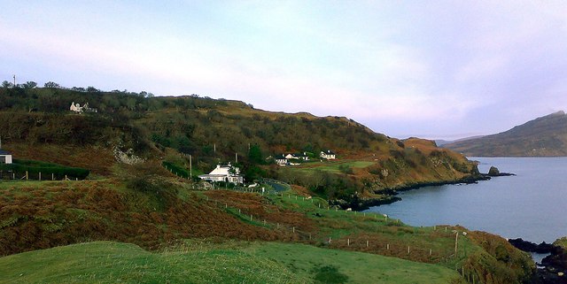
Loch an Amadain is a picturesque freshwater lake located in Inverness-shire, Scotland. Nestled within the scenic surroundings of the Scottish Highlands, this natural beauty spot attracts visitors from near and far.

Covering an area of approximately 50 hectares, Loch an Amadain is a tranquil oasis for both wildlife and nature enthusiasts. Its crystal-clear waters provide a home to a diverse range of aquatic flora and fauna. The lake is fed by several small streams and springs, ensuring a constant flow of fresh water. The surrounding landscape is characterized by rolling hills covered in heather and scattered with ancient oak trees.

The lake's shoreline is lined with dense vegetation, including reeds, rushes, and mosses, creating a thriving habitat for various bird species. Birdwatchers can spot a variety of waterfowl, such as mallards, tufted ducks, and coots. The lake also attracts larger birds of prey, including ospreys and golden eagles, which can be seen soaring above the lake's surface.

Loch an Amadain is a popular spot for fishing enthusiasts, with brown trout being the most common catch. Anglers can enjoy the tranquility of the lake while trying their luck at reeling in a prize fish. The lake is also a great place for water-based activities like kayaking and canoeing, allowing visitors to immerse themselves in the stunning natural surroundings.

Overall, Loch an Amadain offers a peaceful retreat for those seeking a connection with nature. Its scenic beauty, abundant wildlife, and range of recreational activities make it a must-visit destination in Inverness-shire.

If you have any feedback on the listing, please let us know in the comments section below.

Loch an Amadain Images

Images are sourced within 2km of 57.340223/-6.1024064 or Grid Reference NG5335. Thanks to Geograph Open Source API. All images are credited.

Ferry arriving at Clachan, Raasay
Camas a' Mhòr-bheòil Looking north from the beach towards Ben Tianavaig.
Camas a' Mhòr-bheòil
Looking north from the beach towards Ben Tianavaig.
The Cuillin Hills of Skye A view looking south over the roof of the Raasay ferry terminal.
The Cuillin Hills of Skye
A view looking south over the roof of the Raasay ferry terminal.
Arrival at Raasay CalMac's 'Hallaig' puts down its ramp on the island.
Arrival at Raasay
CalMac's 'Hallaig' puts down its ramp on the island.
Welcome to Raasay A welcome from Caledonian MacBrayne as one leaves the ferry from Skye.
Welcome to Raasay
A welcome from Caledonian MacBrayne as one leaves the ferry from Skye.
Rock in Churchton Bay Looking across the bay to Clachan.
Rock in Churchton Bay
Looking across the bay to Clachan.
Southwards from An Aird Looking across the tombolo and Balmeanach Bay towards Glamaig.
Southwards from An Aird
Looking across the tombolo and Balmeanach Bay towards Glamaig.
Loch an Amadain Looking north from An Aird towards Ben Tianavaig, with The Storr in the far distance.
Loch an Amadain
Looking north from An Aird towards Ben Tianavaig, with The Storr in the far distance.
Shoreline rocks, An Aird
Balmeanach Looking south over Balmeanach Bay, to the headland Tòrr Mòr (in the centre).
The hill to the left is Meall a' Mhaoil, with Sconser Quarry just visible.
The red hills are beyond.
Balmeanach
Looking south over Balmeanach Bay, to the headland Tòrr Mòr (in the centre). The hill to the left is Meall a' Mhaoil, with Sconser Quarry just visible. The red hills are beyond.
Ionad Aiseig Eilean Ratharsair/Raasay Ferry Terminal at Clachan With the restored Raasay House, now a hotel, beyond.
Ionad Aiseig Eilean Ratharsair/Raasay Ferry Terminal at Clachan
With the restored Raasay House, now a hotel, beyond.
Raasay mermaid One of a pair at the ferry terminal. See John Allan's description <a href="https://www.geograph.org.uk/photo/1465390">NG5436 : Raasay mermaid</a>.
Raasay mermaid
One of a pair at the ferry terminal. See John Allan's description NG5436 : Raasay mermaid.
Churchton Bay, Raasay From the battery above the ferry terminal building, the roof of which is just visible on the right. The hills of Skye are in the distance.
Churchton Bay, Raasay
From the battery above the ferry terminal building, the roof of which is just visible on the right. The hills of Skye are in the distance.
Shore at the Braes Looking north from above the beach towards Ben Tianavaig.
Camas a' Mhòr-bheòil extends to the right (east).
Sheep are grazing the steep slopes.
Shore at the Braes
Looking north from above the beach towards Ben Tianavaig. Camas a' Mhòr-bheòil extends to the right (east). Sheep are grazing the steep slopes.
Welcome to the Isle of Raasay Forestry Commission information board at the ferry terminal.
Welcome to the Isle of Raasay
Forestry Commission information board at the ferry terminal.
Balmeanach Bay The north side of the bay is a low-lying spit, and in the background are the lava cliffs north of Portree.
Balmeanach Bay
The north side of the bay is a low-lying spit, and in the background are the lava cliffs north of Portree.
Marker buoy on McMillan's Rock McMillan's Rock is a small low-water rock situate near the narrow channel between Raasay and An Aird on Skye. It can only be seen at extreme low tides, and is marked by this buoy.
Marker buoy on McMillan's Rock
McMillan's Rock is a small low-water rock situate near the narrow channel between Raasay and An Aird on Skye. It can only be seen at extreme low tides, and is marked by this buoy.
MV Lochinvar at Churchton Pier The MV Lochinvar is the sister vessel of the MV Hallaig <a title="https://www.geograph.org.uk/photo/3716228," href="https://www.geograph.org.uk/photo/3716228,">Link</a> which normally operates this ferry route between Raasay and Skye. The Lochinvar is more often seen on the Lochaline - Fishnish crossing to Mull, or occasionally supporting on the Oban - Craignure route to Mull. She is covering here as CalMac complete their winter 2017/18 dry dock programme.
MV Lochinvar at Churchton Pier
The MV Lochinvar is the sister vessel of the MV Hallaig Link which normally operates this ferry route between Raasay and Skye. The Lochinvar is more often seen on the Lochaline - Fishnish crossing to Mull, or occasionally supporting on the Oban - Craignure route to Mull. She is covering here as CalMac complete their winter 2017/18 dry dock programme.
Show me another place!

Loch an Amadain is located at Grid Ref: NG5335 (Lat: 57.340223, Lng: -6.1024064)

Unitary Authority: Highland

Police Authority: Highlands and Islands

What 3 Words

///penny.investors.landmark. Near Portree, Highland

Related Wikis

Gedintailor

Gedintailor (Scottish Gaelic: Gead an t-Sailleir) is a crofting village, lying on the shores of the Narrows of Raasay on the east coast of the island of...

Peinachorran

Peinchorran (Scottish Gaelic: Peighinn a' Chorrain; Peinachorrain on Ordnance Survey maps) is a remote settlement, lying at the end of the B883 road, on...

Isle of Raasay distillery

Isle of Raasay distillery is a Scotch whisky distillery on the Inner Hebridean Isle of Raasay in Northwest Scotland. The distillery is owned by R&B Distillers...

Ollach

Ollach (in Scottish Gaelic, An t-Olach) is a remote settlement, made up of Lower Ollach and Upper Ollach, lying on B883 road, south of Portree, Isle of...

Nearby Amenities

Located within 500m of 57.340223,-6.1024064
Source: PGS
Lat/Long: 57.3368007/-6.1044565
Source: PGS
Lat/Long: 57.3376692/-6.102835
Source: PGS
Lat/Long: 57.3381837/-6.1014275
Source: PGS
Lat/Long: 57.3384879/-6.1003731
Source: PGS
Lat/Long: 57.3386995/-6.0992222
Source: PGS
Lat/Long: 57.3386861/-6.09826
Source: PGS
Lat/Long: 57.3386695/-6.0971928
Source: PGS
Lat/Long: 57.3388795/-6.0957094
Source: PGS
Lat/Long: 57.3390193/-6.0951181
Source: PGS
Lat/Long: 57.3391919/-6.0947662
Power: pole
Lat/Long: 57.3369815/-6.1073926
Power: pole
Lat/Long: 57.3372667/-6.106258
Power: pole
Lat/Long: 57.3375656/-6.105157
Power: pole
Lat/Long: 57.3379796/-6.1035611
Power: pole
Lat/Long: 57.3379557/-6.1034471
Location Transition: yes
Power: pole
Lat/Long: 57.3379289/-6.1033089
An Àird
Natural: cape
Lat/Long: 57.3433365/-6.1025371
The data included in this document is from www.openstreetmap.org. The data is made available under ODbL.

Have you been to Loch an Amadain?

Leave your review of Loch an Amadain below (or comments, questions and feedback).