Gergask

Settlement in Inverness-shire

Scotland

Gergask

Laggan to Garva road By Blargie
Laggan to Garva road Credit: Richard Webb

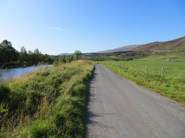
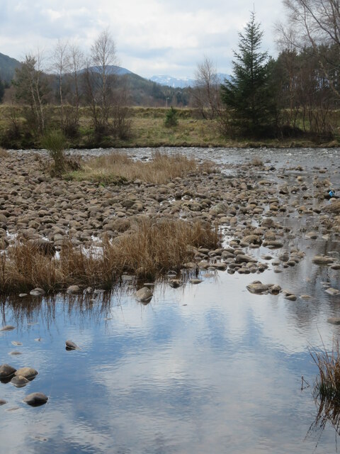
Gergask is a small village located in the Highland region of Scotland, specifically in the county of Inverness-shire. Situated in the heart of the Scottish Highlands, it is surrounded by breathtaking landscapes, including lush green hills, vast forests, and tranquil lochs. The village is nestled on the banks of the River Spey, one of Scotland's most famous salmon rivers.

With a population of only a few dozen residents, Gergask is a peaceful and close-knit community. The village mainly consists of traditional stone houses, giving it a charming and rustic atmosphere. The locals rely on agriculture and fishing as their primary sources of income, with many farms dotting the surrounding countryside.

Nature enthusiasts are drawn to Gergask due to its proximity to the Cairngorms National Park, which offers a wide range of outdoor activities, including hiking, mountain biking, and wildlife spotting. The area is also known for its abundance of bird species, making it a popular destination for birdwatchers.

Although Gergask is a small village, it is conveniently located near larger towns such as Kingussie and Aviemore, where residents and visitors can find a wider range of amenities and services. Additionally, the nearby A9 road provides easy access to Inverness, the capital city of the Highlands.

Overall, Gergask offers a tranquil and picturesque setting for those seeking a peaceful retreat in the midst of Scotland's stunning natural landscapes.

If you have any feedback on the listing, please let us know in the comments section below.

Gergask Images

Images are sourced within 2km of 57.020771/-4.28673 or Grid Reference NN6194. Thanks to Geograph Open Source API. All images are credited.

Laggan to Garva road By Blargie
Laggan to Garva road
By Blargie
Beside the Spey Flowers on a bank between river and road.
Beside the Spey
Flowers on a bank between river and road.
Minor road south of Blargie A straight section of minor road south of Blargie, which can be seen in the distance on the right side of the small plantation. Blargie Craig is the hill in the background.
Minor road south of Blargie
A straight section of minor road south of Blargie, which can be seen in the distance on the right side of the small plantation. Blargie Craig is the hill in the background.
River Spey downstream of the dam The road up the glen runs along the north bank at this point.
River Spey downstream of the dam
The road up the glen runs along the north bank at this point.
Fence-lined minor road near to Blargie Looking south-westward.
Fence-lined minor road near to Blargie
Looking south-westward.
Minor road beside River Spey near to Creag nan Each Looking north-westward.
Minor road beside River Spey near to Creag nan Each
Looking north-westward.
On the banks of the Spey The River Spey, a mile or so downstream from Spey Dam.
On the banks of the Spey
The River Spey, a mile or so downstream from Spey Dam.
A86 between Laggan and Spean Bridge
Minor road near Blargie
Rock outcrops beyond flat pasture The mountains of the Creag Meagaidh range on the horizon.
Rock outcrops beyond flat pasture
The mountains of the Creag Meagaidh range on the horizon.
River Spey
River Spey
Pasture below Blargie Craig
The River Spey Looking downstream on a late-October afternoon.
The River Spey
Looking downstream on a late-October afternoon.
The River Spey Looking upstream near Spey Dam on a late-October afternoon with lots of shower cloud activity.
The River Spey
Looking upstream near Spey Dam on a late-October afternoon with lots of shower cloud activity.
Homeward bound An image characteristic of long Geograph trips in the Highlands - returning home late in the day, car headlight beams cutting into the night - on this occasion 2km west of Laggan, after a day's walking in the Monadhliath.
Homeward bound
An image characteristic of long Geograph trips in the Highlands - returning home late in the day, car headlight beams cutting into the night - on this occasion 2km west of Laggan, after a day's walking in the Monadhliath.
Fields west of Blargie Flat meadows.
Fields west of Blargie
Flat meadows.
The Spey at Eilean Dubh The islet of Eilean Dubh can be seen on the left of the picture, with the southern channel around it to its right.
The Spey at Eilean Dubh
The islet of Eilean Dubh can be seen on the left of the picture, with the southern channel around it to its right.
River Spey
River Spey
Show me another place!

Gergask is located at Grid Ref: NN6194 (Lat: 57.020771, Lng: -4.28673)

Unitary Authority: Highland

Police Authority: Highlands and Islands

What 3 Words

///trek.hypocrite.stopped. Near Newtonmore, Highland

Nearby Locations

Gergask Laggan

Related Wikis

Laggan, Badenoch

Laggan (Gaelic: Lagan ) is a village in Badenoch, in the Highland region of Scotland. It is beside the River Spey, about 10 km west of Newtonmore. The...

Catlodge

Catlodge (Scottish Gaelic: Caitleag) is a hamlet, in the district of Newtonmore in Inverness-shire, Scottish Highlands and is in the Scottish council...

Dùn dà Làmh

Dùn dà Làmh is a Pictish now ruined hill fort near Laggan in the Scottish Highlands. It became a scheduled monument in 1986, with an extension to the protected...

Creag Dhubh (Newtonmore)

Creag Dhubh (756 m) is a mountain in the Grampian Mountains of Scotland. It is located in the Strathspey area of the central Highlands, above the village...

Related Videos

Bikepacking Scotland's East Highland Way

A shakey cam adventure docu-horror about a guy biking past his camera lots of times. *** FILMED BEFORE THE COVID-19 ...

Scotland🏴󠁧󠁢󠁳󠁣󠁴󠁿

July 2014 The Snyders continue their bizarre journey north from their ancestral lands in Northumberland to the Highlands of ...

Visit to pattack falls in the van #vanlife wandering & adventures

this was an amazing find and well worth a visit, please enjoy. the place wasn't the biggest for parking but definitely worth a visit.

Nearby Amenities

Located within 500m of 57.020771,-4.28673
Laggan
Name Gd: Lagan
Place: village
Wikidata: Q6472057
Wikipedia: en:Laggan, Badenoch
Lat/Long: 57.0192779/-4.2829357
Post Box
Collection Times: Mo-Fr 12:45; Sa 07:00
Operator: Royal Mail
Post Box Type: lamp
Ref: PH20 57
Royal Cypher: scottish_crown
Lat/Long: 57.0196176/-4.2831928
Toilets
Check Date: 2022-02-27
Fee: no
Wheelchair: yes
Wikidata: Q114076761
Lat/Long: 57.0195247/-4.2835466
Give Way
Direction: backward
Lat/Long: 57.0194116/-4.2832037
Barrier: cattle_grid
Bicycle: yes
Foot: yes
Motorcar: yes
Lat/Long: 57.021471/-4.2930579
Give Way
Direction: backward
Lat/Long: 57.0206535/-4.2867632
Post Box
Collection Times: Mo-Fr 12:45; Sa 07:00
Operator: Royal Mail
Post Box Type: lamp
Ref: PH20 14
Royal Cypher: scottish_crown
Lat/Long: 57.0201671/-4.2877243
Telephone
Booth: K6
Covered: booth
Lat/Long: 57.0201506/-4.2876374
Entrance: yes
Lat/Long: 57.0201761/-4.2859053
Recycling
Location: overground
Recycling Clothes: yes
Recycling Glass: no
Recycling Glass Bottles: yes
Recycling Paper: yes
Recycling Type: container
Lat/Long: 57.0201162/-4.2852331
Parking
Parking: street_side
Lat/Long: 57.0200875/-4.2850375
Gergask
Place: hamlet
Lat/Long: 57.0200592/-4.2876519
Kirk Laggan Bridge
Board Type: board
Information: board
Tourism: information
Lat/Long: 57.0188494/-4.2834328
Memorial to Neil Usher
Historic: memorial
Lat/Long: 57.0200065/-4.2849227
Addr City: Laggan
Addr Housenumber: 10
Addr Street: Gergask Avenue
Lat/Long: 57.019377/-4.2868579
Addr City: Laggan
Addr Housenumber: 11
Addr Street: Gergask Avenue
Lat/Long: 57.0196471/-4.2868813
Addr City: Laggan
Addr Housenumber: 12
Addr Street: Gergask Avenue
Lat/Long: 57.0197721/-4.2869248
Addr City: Laggan
Addr Housenumber: 7
Addr Street: Gergask Avenue
Lat/Long: 57.0192914/-4.2875334
Addr City: Laggan
Addr Housenumber: 8
Addr Street: Gergask Avenue
Lat/Long: 57.0192922/-4.2878051
Addr City: Laggan
Addr Housenumber: 9
Addr Street: Gergask Avenue
Lat/Long: 57.01931/-4.2867739
Board Type: notice
Check Date: 2022-02-27
Information: board
Tourism: information
Lat/Long: 57.0194955/-4.2830745
Fixme: continues
Lat/Long: 57.0195079/-4.2844186
Fixme: continues
Lat/Long: 57.0194068/-4.2850405
Tourism: picnic_site
Lat/Long: 57.0196462/-4.2851116
Post Office
Laggan Post Office
Addr City: Newtonmore
Addr Housename: Laggan Village Hall
Addr Postcode: PH20 1AH
Addr Suburb: Laggan
Opening Hours: We 09:00-11:00
Ref Pol Id: 95154
Lat/Long: 57.02045/-4.2868393
Cafe
Laggan Coffee Bothy & Gallery
Changing Table: yes
Check Date: 2024-05-08
Email: info@lagganstores.co.uk
Internet Access: wlan
Opening Hours: Tu-Sa 09:30-16:00 Su 11:00-14:00
Outdoor Seating: yes
Phone: +44 7795 163452
Takeaway: yes
Toilets: yes
Website: http://www.lagganstores.co.uk/
Lat/Long: 57.0196761/-4.2832667
Power: pole
Lat/Long: 57.0211434/-4.2939394
Location Transition: yes
Power: pole
Lat/Long: 57.0211004/-4.2933832
Power: pole
Lat/Long: 57.0199991/-4.2880245
Power: pole
Lat/Long: 57.0203193/-4.287759
Frequency: 50
Location Transition: yes
Material: wood
Phases: 3
Power: pole
Transformer: distribution
Voltage Primary: 11000
Voltage Secondary: 400
Lat/Long: 57.0207245/-4.2874364
Material: wood
Power: pole
Lat/Long: 57.0209257/-4.2866399
Material: wood
Power: pole
Lat/Long: 57.0206623/-4.2856585
Material: wood
Power: pole
Lat/Long: 57.0204263/-4.2847579
Material: wood
Power: pole
Lat/Long: 57.0202159/-4.2839043
Material: wood
Power: pole
Lat/Long: 57.0200522/-4.2828087
Power: pole
Lat/Long: 57.0198839/-4.2816912
Frequency: 50
Line Management: split
Phases: 3
Power: pole
Transformer: distribution
Voltage Primary: 11000
Voltage Secondary: 400
Lat/Long: 57.0196156/-4.2814422
Power: pole
Lat/Long: 57.0190926/-4.2814627
Power: pole
Lat/Long: 57.0180663/-4.2814711
Power: pole
Lat/Long: 57.0176336/-4.2814829
Power: pole
Lat/Long: 57.0199662/-4.2805671
Power: pole
Lat/Long: 57.0203385/-4.2795958
Power: pole
Lat/Long: 57.0206577/-4.2788111
Defibrillator
Defibrillator Location: Outside wall of Laggan Village Hall, beside entrance at west
Emergency: defibrillator
Indoor: no
Lat/Long: 57.0204994/-4.2868484
Entrance: main
Lat/Long: 57.0191721/-4.2827193
Entrance: main
Lat/Long: 57.0204898/-4.2868481
Grit Bin
Lat/Long: 57.020565/-4.2867834
The data included in this document is from www.openstreetmap.org. The data is made available under ODbL.

Have you been to Gergask?

Leave your review of Gergask below (or comments, questions and feedback).