Aveley

Settlement in Essex

England

Aveley

Footpath in Mardyke Woods
Footpath in Mardyke Woods Credit: Adrian Benn

Aveley is a village and civil parish located in the Thurrock unitary authority of Essex, England. Situated on the northern bank of the River Thames, Aveley is positioned approximately 16 miles east of London's city center. The village is part of the wider Thurrock borough, which encompasses a mix of rural and urban areas.

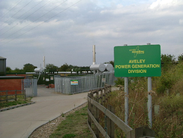
Aveley boasts a rich history, dating back to the Roman era when it was a significant agricultural settlement. Over the centuries, it evolved into a thriving industrial hub, with its proximity to the Thames facilitating trade and transport. Today, Aveley retains remnants of its past, including some historic buildings and landmarks.

The village is characterized by a mix of residential and commercial areas. It offers a range of amenities, including shops, supermarkets, pubs, and restaurants, catering to the needs of its residents. Additionally, Aveley is home to several schools, providing educational opportunities for children of all ages.

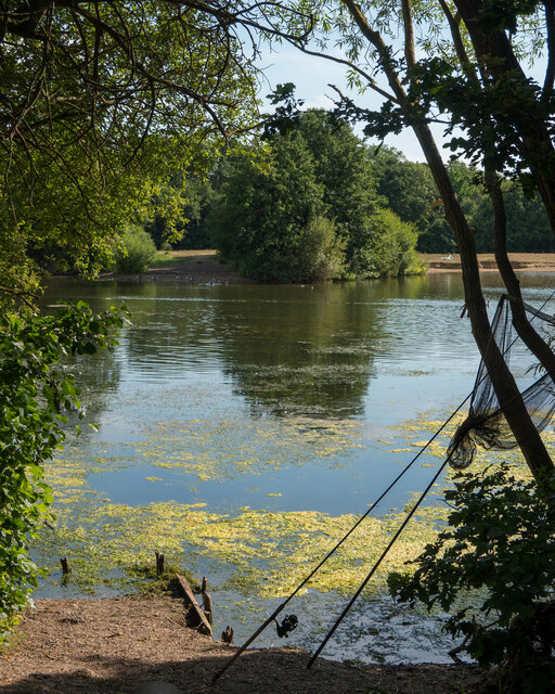
The natural surroundings of Aveley are also noteworthy. The village is bordered by expansive green spaces, such as Belhus Woods Country Park and Aveley Recreation Ground, offering opportunities for outdoor activities and leisure. Moreover, the River Thames provides a picturesque backdrop and opportunities for boating and fishing enthusiasts.

Transportation in Aveley is well-connected, with easy access to major road networks like the A13 and M25, facilitating travel to nearby towns and cities. The village is also served by bus routes, connecting it to neighboring areas and train stations.

Overall, Aveley presents a blend of historical charm, modern amenities, and natural beauty, making it a desirable place to live or visit in Essex.

If you have any feedback on the listing, please let us know in the comments section below.

Aveley Images

Images are sourced within 2km of 51.50346/0.256384 or Grid Reference TQ5680. Thanks to Geograph Open Source API. All images are credited.

Footpath in Mardyke Woods
Flooded Path alongside Mardyke Woods
Tree on one of the ex-gravel pit lakes at Belhus Woods Country Park Sections of Belhus Woods Country Park park were originally part of the Belhus Estate, the grounds of which were designed by Capability Brown; some remnants of which can still be seen.

As well as the areas of grassland and woodland, past gravel extraction on the site has created a series of lakes and clay extraction has created a number of small ponds.

The park includes land owned by Thurrock Council and Essex County Council and is managed by Essex County Council Ranger Service. 

It is situated within Thames Chase Community Forest and borders woodland owned by the Woodland Trust and Forestry Commission.

It is linked to the Oakwood and Ash Plantation by a footbridge <a href="https://www.geograph.org.uk/photo/2651109">TQ5781 : Longpond footbridge</a>.

See <span class="nowrap"><a title="http://www.visitparks.co.uk/placestovisit/belhuscountrypark.php" rel="nofollow ugc noopener" href="http://www.visitparks.co.uk/placestovisit/belhuscountrypark.php">Link</a><img style="margin-left:2px;" alt="External link" title="External link - shift click to open in new window" src="https://s1.geograph.org.uk/img/external.png" width="10" height="10"/></span>
Tree on one of the ex-gravel pit lakes at Belhus Woods Country Park
Sections of Belhus Woods Country Park park were originally part of the Belhus Estate, the grounds of which were designed by Capability Brown; some remnants of which can still be seen. As well as the areas of grassland and woodland, past gravel extraction on the site has created a series of lakes and clay extraction has created a number of small ponds. The park includes land owned by Thurrock Council and Essex County Council and is managed by Essex County Council Ranger Service. It is situated within Thames Chase Community Forest and borders woodland owned by the Woodland Trust and Forestry Commission. It is linked to the Oakwood and Ash Plantation by a footbridge TQ5781 : Longpond footbridge. See LinkExternal link
The A13 at Mar Dyke Interchange, Aveley
Rain on lake in Belhus Woods Country Park Just starting to rain after a long dry period
Rain on lake in Belhus Woods Country Park
Just starting to rain after a long dry period
Angler's view, Belhus Woods Country Park These sections are well used by anglers, as can be seen here with a net leaning against a tree.
Angler's view, Belhus Woods Country Park
These sections are well used by anglers, as can be seen here with a net leaning against a tree.
Limbs entwined (summer), Belhus Woods Country Park Compare to <a href="https://www.geograph.org.uk/photo/5260169">TQ5782 : Limbs entwined, like two old friends, Belhus Woods Country Park</a> taken in winter a few years ago.
Limbs entwined (summer), Belhus Woods Country Park
20 zone on Ship Lane, Aveley
M25 northbound, within Junction 30
Premier Inn Thurrock West
Footpath into Watt's Wood, Purfleet
Ship Lane nearing Aveley on bridge over A13
Arterial Road, Purfleet The car sales opposite appears to have closed as there is now a fence in front and no dealership signs.
Arterial Road, Purfleet
The car sales opposite appears to have closed as there is now a fence in front and no dealership signs.
Thames Chase at  Belhus Newly planted mixed woodland in Belhus Park. South Ockendon. Part of Thames Chase the new community forest to the East of London. See a couple of years more growth at <a href="https://www.geograph.org.uk/photo/536329">TQ5781 : Belhus Chase</a>. For more information see the Woodland Trust Website <span class="nowrap"><a title="http://www.woodlandtrust.org.uk/visiting-woods/wood-information/belhus-chase/" rel="nofollow ugc noopener" href="http://www.woodlandtrust.org.uk/visiting-woods/wood-information/belhus-chase/">Link</a><img style="margin-left:2px;" alt="External link" title="External link - shift click to open in new window" src="https://s1.geograph.org.uk/img/external.png" width="10" height="10"/></span>
Thames Chase at Belhus
Newly planted mixed woodland in Belhus Park. South Ockendon. Part of Thames Chase the new community forest to the East of London. See a couple of years more growth at TQ5781 : Belhus Chase. For more information see the Woodland Trust Website LinkExternal link
Kennington Park Lake The flooded gravel pit shown and its environs have during the past ten years  been remodelled into a country park for recreation. This is part of Thames Chase community forest.
Kennington Park Lake
The flooded gravel pit shown and its environs have during the past ten years been remodelled into a country park for recreation. This is part of Thames Chase community forest.
Fishing & Farming The image shows a private fishing lake a diversification from arable agriculture
Fishing & Farming
The image shows a private fishing lake a diversification from arable agriculture
Methane from Muck This plant in Sandy Lane Aveley Essex collects methane  from covered over landfill sites. The gas produced was piped to the Thames Board Mill in Purfleet. The mill is in the process of closing so new markets will need to be found for the gas. The plant has the advantage of preventing gas from leaking into nearby homes.
Methane from Muck
This plant in Sandy Lane Aveley Essex collects methane from covered over landfill sites. The gas produced was piped to the Thames Board Mill in Purfleet. The mill is in the process of closing so new markets will need to be found for the gas. The plant has the advantage of preventing gas from leaking into nearby homes.
All Gone Home (Derwent Parade) Derwent Parade South Ockendon Essex, built in the 1950’s to provide retail services to  the LCC (later GLC) overspill housing estate that surrounds it.  The name sign is the result of a recent revamp.
All Gone Home (Derwent Parade)
Derwent Parade South Ockendon Essex, built in the 1950’s to provide retail services to the LCC (later GLC) overspill housing estate that surrounds it. The name sign is the result of a recent revamp.
Show me another place!

Aveley is located at Grid Ref: TQ5680 (Lat: 51.50346, Lng: 0.256384)

Unitary Authority: Thurrock

Police Authority: Essex

What 3 Words

///rubble.defend.lasted. Near Aveley, Essex

Nearby Locations

Aveley

Related Wikis

Aveley

Aveley is a town and former civil parish in the unitary authority of Thurrock in Essex, England, and forms one of the traditional Church of England parishes...

Aveley F.C.

Aveley Football Club are a semi–professional football club based in Aveley, Essex, England. They are currently members of the National League South and...

Grays Athletic F.C.

Grays Athletic Football Club is a football club based in Grays, Essex, England. They are currently members of the Isthmian League North Division and play...

May & Baker F.C.

May & Baker Eastbrook Community Football Club is a football club based in Dagenham, Greater London, England. They are currently members of the Eastern...

Nearby Amenities

Located within 500m of 51.50346,0.256384
Traffic Calming: island
Lat/Long: 51.5021008/0.2507615
Aveley
Is In: Essex, England, GB
Is In Country: United Kingdom
Is In Country Code: GB
Is In County: Essex
Place: village
Wikidata: Q2449718
Lat/Long: 51.5001066/0.2561792
Mini Roundabout
Direction: clockwise
Lat/Long: 51.5031501/0.249331
Traffic Calming: bump
Lat/Long: 51.5050641/0.2596791
Barrier: bollard
Lat/Long: 51.5006569/0.2537657
Post Box
Brand: Royal Mail
Brand Wikidata: Q638098
Operator: Royal Mail
Operator Wikidata: Q638098
Ref: RM15 224
Lat/Long: 51.5062101/0.2523951
Bus Stop
Hanford Road
Naptan AtcoCode: 1590004501
Naptan Bearing: N
Naptan CommonName: Hanford Road
Naptan Indicator: Northbound
Naptan Landmark: Hanford Road
Naptan NaptanCode: thuagap
Naptan Street: Mill Road
Naptan Verified: no
Public Transport: platform
Source: naptan_import
Lat/Long: 51.5009491/0.2511842
Bus Stop
Hanford Road
Naptan AtcoCode: 1590004601
Naptan Bearing: S
Naptan CommonName: Hanford Road
Naptan Indicator: Southbound
Naptan Landmark: Hanford Road
Naptan NaptanCode: thuagat
Naptan Street: Mill Road
Naptan Verified: no
Public Transport: platform
Source: naptan_import
Lat/Long: 51.5007216/0.251456
Bus Stop
Teviot Avenue
Bus: yes
Naptan AtcoCode: 1590005101
Naptan Bearing: N
Naptan CommonName: Teviot Avenue
Naptan Indicator: Northbound
Naptan Landmark: Shannon Way
Naptan NaptanCode: thuagda
Naptan Street: Teviot Avenue
Naptan Verified: no
Public Transport: platform
Source: naptan_import
Lat/Long: 51.5073542/0.2533702
Noexit: yes
Lat/Long: 51.5005137/0.2562089
Traffic Calming: table
Lat/Long: 51.5030048/0.2562639
Crossing
Crossing: unmarked
Crossing Island: no
Tactile Paving: yes
Lat/Long: 51.5009112/0.255016
Community Centre
Aveley Scouts
Addr City: Aveley
Addr Housename: Orminston Park Academy
Club: scout
Community Centre: club_home
Community Centre For: scout
Operator: Aveley Scouts
Website: https://www.thurrockscouts.org.uk/groups/aveley
Lat/Long: 51.5054858/0.2543799
Barrier: bollard
Lat/Long: 51.502475/0.2505984
Traffic Calming: bump
Lat/Long: 51.504413/0.2595521
Crossing
Tactile Paving: yes
Traffic Calming: table
Lat/Long: 51.5046787/0.257012
Crossing
Crossing: unmarked
Crossing Island: no
Tactile Paving: yes
Lat/Long: 51.5017579/0.2595209
Crossing
Crossing: unmarked
Crossing Island: no
Tactile Paving: yes
Traffic Calming: table
Lat/Long: 51.5025544/0.2594941
Crossing
Bicycle: yes
Crossing: traffic_signals
Lat/Long: 51.5026774/0.25952
Bus Stop
Ormiston Park Academy
Bus: yes
Naptan AtcoCode: 1590705216
Naptan BusStopType: CUS
Naptan NaptanCode: thudtad
Naptan Verified: no
Public Transport: platform
Source: naptan
Lat/Long: 51.506108/0.2540044
Traffic Calming: bump
Lat/Long: 51.5031469/0.2601265
Noexit: yes
Lat/Long: 51.5028515/0.2536929
Barrier: bollard
Lat/Long: 51.5008372/0.2601957
Barrier: cycle_barrier
Lat/Long: 51.502271/0.2548677
Barrier: bollard
Lat/Long: 51.5017082/0.2595109
Barrier: bollard
Lat/Long: 51.5017996/0.2595258
Crossing
Crossing: unmarked
Crossing Island: no
Tactile Paving: yes
Lat/Long: 51.502356/0.2597026
Crossing
Crossing: unmarked
Crossing Island: no
Tactile Paving: yes
Lat/Long: 51.5012436/0.2610978
Bicycle Parking
Bicycle Parking: stands
Capacity: 8
Lat/Long: 51.5004378/0.2612799
Crossing
Crossing: unmarked
Crossing Island: no
Tactile Paving: yes
Lat/Long: 51.500854/0.2595218
Barrier: cycle_barrier
Lat/Long: 51.5018285/0.2593189
Noexit: yes
Lat/Long: 51.4994217/0.258724
Noexit: yes
Lat/Long: 51.4993818/0.2587147
Noexit: yes
Lat/Long: 51.4991731/0.256848
Crossing
Crossing: unmarked
Crossing Island: yes
Tactile Paving: yes
Lat/Long: 51.5029987/0.2582831
Crossing
Crossing: unmarked
Crossing Island: no
Tactile Paving: yes
Lat/Long: 51.5025653/0.2591327
Crossing
Crossing: marked
Crossing Island: no
Tactile Paving: yes
Lat/Long: 51.5025795/0.2578328
Crossing
Crossing: unmarked
Crossing Island: no
Tactile Paving: yes
Lat/Long: 51.5029424/0.2564614
Crossing
Crossing: marked
Crossing Island: no
Tactile Paving: yes
Lat/Long: 51.5025098/0.2575969
Crossing
Crossing: marked
Crossing Island: no
Tactile Paving: yes
Lat/Long: 51.5024227/0.2578234
Traffic Calming: bump
Lat/Long: 51.5026855/0.2571356
Crossing
Crossing: unmarked
Crossing Island: no
Tactile Paving: yes
Lat/Long: 51.5030589/0.2560929
Crossing
Crossing: unmarked
Crossing Island: no
Tactile Paving: yes
Lat/Long: 51.5030527/0.2562578
Crossing
Crossing: unmarked
Crossing Island: no
Tactile Paving: yes
Lat/Long: 51.5029414/0.256272
Crossing
Crossing: unmarked
Crossing Island: no
Tactile Paving: yes
Lat/Long: 51.5033085/0.2550711
Crossing
Crossing: unmarked
Crossing Island: no
Tactile Paving: yes
Lat/Long: 51.5032116/0.2552335
Crossing
Crossing: unmarked
Crossing Island: no
Tactile Paving: yes
Lat/Long: 51.503242/0.2553679
Bicycle Parking
Bicycle Parking: stands
Covered: no
Lat/Long: 51.5029787/0.2549878
Bicycle Parking
Bicycle Parking: stands
Covered: no
Lat/Long: 51.5030227/0.254715
Crossing
Crossing: unmarked
Crossing Island: no
Tactile Paving: yes
Lat/Long: 51.5032914/0.2546309
Crossing
Crossing: unmarked
Crossing Island: no
Tactile Paving: yes
Lat/Long: 51.5033913/0.2545124
Crossing
Crossing: unmarked
Crossing Island: no
Tactile Paving: yes
Lat/Long: 51.5034103/0.254894
Crossing
Crossing: unmarked
Crossing Island: no
Tactile Paving: yes
Lat/Long: 51.5033914/0.2538515
Barrier: bollard
Lat/Long: 51.502613/0.2516987
Crossing
Crossing: unmarked
Crossing Island: no
Tactile Paving: yes
Lat/Long: 51.5024526/0.2504242
Crossing
Crossing: unmarked
Crossing Island: no
Tactile Paving: yes
Lat/Long: 51.5032118/0.2494136
Crossing
Crossing: unmarked
Crossing Island: no
Tactile Paving: yes
Lat/Long: 51.5028443/0.2499117
Traffic Calming: island
Lat/Long: 51.5032023/0.2492356
Noexit: yes
Lat/Long: 51.5028276/0.2536308
Noexit: yes
Lat/Long: 51.5025382/0.251715
Traffic Calming: island
Lat/Long: 51.5018084/0.2509352
Barrier: bollard
Lat/Long: 51.5002407/0.2538323
Barrier: bollard
Lat/Long: 51.5002172/0.2528994
Turning Circle
Lat/Long: 51.4996254/0.2537857
Stop
Direction: backward
Lat/Long: 51.4997808/0.254978
Stop
Direction: backward
Lat/Long: 51.500058/0.2546883
Turning Circle
Lat/Long: 51.5004848/0.2562077
Noexit: yes
Lat/Long: 51.4992834/0.2553618
Crossing
Crossing: marked
Lat/Long: 51.5047945/0.2543275
Crossing
Crossing: marked
Lat/Long: 51.5046544/0.2543124
Crossing
Crossing: marked
Lat/Long: 51.5046405/0.2546816
Crossing
Crossing: marked
Lat/Long: 51.5047826/0.2546969
Crossing
Crossing: marked
Lat/Long: 51.5049325/0.2547132
Crossing
Crossing: marked
Lat/Long: 51.5049479/0.254345
Crossing
Crossing: marked
Lat/Long: 51.5031027/0.2599191
Crossing
Crossing: marked
Lat/Long: 51.5031328/0.2601317
Crossing
Crossing: marked
Lat/Long: 51.5031638/0.2603511
Crossing
Crossing: marked
Lat/Long: 51.5033629/0.2600437
Crossing
Crossing: marked
Lat/Long: 51.5033954/0.2602589
Traffic Calming: bump
Lat/Long: 51.5033739/0.2600395
Traffic Calming: bump
Lat/Long: 51.5033428/0.2598334
Traffic Calming: bump
Lat/Long: 51.5034053/0.2602549
Traffic Calming: bump
Lat/Long: 51.503524/0.2602076
Traffic Calming: bump
Lat/Long: 51.5036271/0.2597319
Traffic Calming: bump
Lat/Long: 51.5036562/0.2599312
Traffic Calming: bump
Lat/Long: 51.5031158/0.2599144
Traffic Calming: bump
Lat/Long: 51.5031786/0.2603452
Crossing
Crossing: unmarked
Crossing Island: no
Tactile Paving: yes
Lat/Long: 51.5038996/0.2594639
Crossing
Crossing: unmarked
Crossing Island: no
Tactile Paving: yes
Lat/Long: 51.5038525/0.2595753
Traffic Calming: bump
Lat/Long: 51.5059193/0.2598849
Traffic Calming: bump
Lat/Long: 51.5063641/0.2607307
The data included in this document is from www.openstreetmap.org. The data is made available under ODbL.

Have you been to Aveley?

Leave your review of Aveley below (or comments, questions and feedback).