Loch Cleiter

Lake, Pool, Pond, Freshwater Marsh in Ross-shire

Scotland

Loch Cleiter

Great Bernera bridges The new bridge under construction and the old white bridge.
Great Bernera bridges Credit: Catherine Morgan

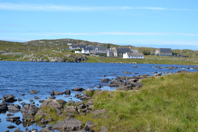
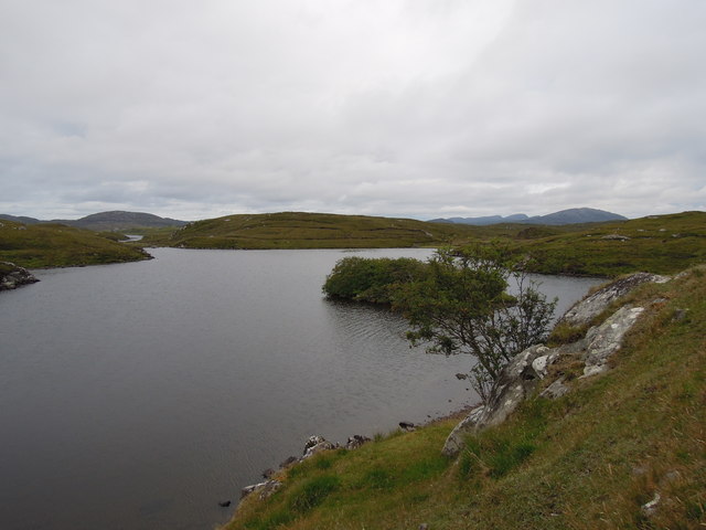
Loch Cleiter is a stunning freshwater loch located in Ross-shire, Scotland. Situated amidst the picturesque Scottish Highlands, this natural water body is known for its tranquil beauty and diverse ecosystem. The loch stretches over an area of approximately 50 acres, making it a medium-sized body of water.

Surrounded by rolling hills and lush greenery, Loch Cleiter offers a peaceful and scenic environment. The calm waters of the loch reflect the surrounding landscape, creating a mesmerizing sight for visitors. The lake is fed by several small streams and springs, ensuring a constant flow of freshwater throughout the year.

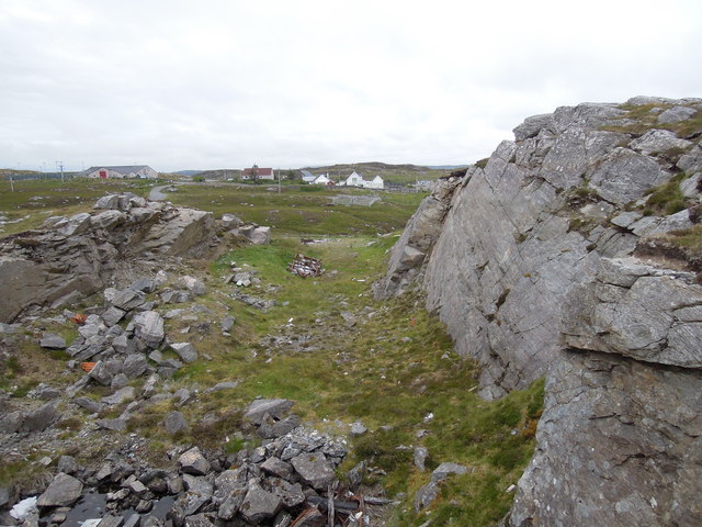
The diverse flora and fauna found in and around Loch Cleiter make it a haven for nature enthusiasts. The surrounding area is covered with dense vegetation, including heather, ferns, and wildflowers, providing a habitat for various species of birds, insects, and small mammals. Birdwatchers can spot a variety of avian species, including herons, ducks, and swans.

The loch also supports a rich aquatic life, with fish such as trout and perch inhabiting its depths. Anglers often visit Loch Cleiter to enjoy a peaceful fishing experience. Additionally, the freshwater marshes surrounding the loch provide a habitat for amphibians and wetland plants, adding to the biodiversity of the area.

Loch Cleiter offers a serene and natural escape for those seeking tranquility amidst Scotland's stunning landscape. Whether it's for fishing, birdwatching, or simply enjoying the breathtaking scenery, Loch Cleiter is a hidden gem in Ross-shire that never fails to captivate visitors with its natural beauty.

If you have any feedback on the listing, please let us know in the comments section below.

Loch Cleiter Images

Images are sourced within 2km of 58.209043/-6.8326756 or Grid Reference NB1634. Thanks to Geograph Open Source API. All images are credited.

Great Bernera bridges The new bridge under construction and the old white bridge.
Great Bernera bridges
The new bridge under construction and the old white bridge.
"The Bridge Across the Atlantic" Bernera Bridge is one of several bridges which claim to span the Atlantic Ocean. This one connects the Lewis mainland with the island of Great Bernera / Bearnaraigh. Note the standing stones on the far side of the bridge.
<span class="nowrap"><a title="http://www.uigandbernera.com/" rel="nofollow ugc noopener" href="http://www.uigandbernera.com/">Link</a><img style="margin-left:2px;" alt="External link" title="External link - shift click to open in new window" src="https://s1.geograph.org.uk/img/external.png" width="10" height="10"/></span>
"The Bridge Across the Atlantic"
Bernera Bridge is one of several bridges which claim to span the Atlantic Ocean. This one connects the Lewis mainland with the island of Great Bernera / Bearnaraigh. Note the standing stones on the far side of the bridge. LinkExternal link
Loch Ionail Freshwater loch on the island of Great Bernera / Bearnaraigh.
<span class="nowrap"><a title="http://www.uigandbernera.com/" rel="nofollow ugc noopener" href="http://www.uigandbernera.com/">Link</a><img style="margin-left:2px;" alt="External link" title="External link - shift click to open in new window" src="https://s1.geograph.org.uk/img/external.png" width="10" height="10"/></span>
Loch Ionail
Freshwater loch on the island of Great Bernera / Bearnaraigh. LinkExternal link
Bernera Bridge Opened in 1953 and connecting Lewis with Great Bernera / Bearnaraigh.
<span class="nowrap"><a title="http://www.uigandbernera.com/" rel="nofollow ugc noopener" href="http://www.uigandbernera.com/">Link</a><img style="margin-left:2px;" alt="External link" title="External link - shift click to open in new window" src="https://s1.geograph.org.uk/img/external.png" width="10" height="10"/></span>
Bernera Bridge
Opened in 1953 and connecting Lewis with Great Bernera / Bearnaraigh. LinkExternal link
Sea Kayakers by Port a Chruidh Kayakers who have come from Miavaig / Miabhaig and are heading eastwards, having just passed below Bernera Bridge. The mainland of Lewis is on the far side of the 1953 bridge.
<span class="nowrap"><a title="http://www.uigandbernera.com/" rel="nofollow ugc noopener" href="http://www.uigandbernera.com/">Link</a><img style="margin-left:2px;" alt="External link" title="External link - shift click to open in new window" src="https://s1.geograph.org.uk/img/external.png" width="10" height="10"/></span>
Sea Kayakers by Port a Chruidh
Kayakers who have come from Miavaig / Miabhaig and are heading eastwards, having just passed below Bernera Bridge. The mainland of Lewis is on the far side of the 1953 bridge. LinkExternal link
Lewisian Gneiss Pink, folded Lewisian gneiss at the north end of Bernera Bridge. These are amongst the oldest rocks in the world.
<span class="nowrap"><a title="http://www.uigandbernera.com/" rel="nofollow ugc noopener" href="http://www.uigandbernera.com/">Link</a><img style="margin-left:2px;" alt="External link" title="External link - shift click to open in new window" src="https://s1.geograph.org.uk/img/external.png" width="10" height="10"/></span>
Lewisian Gneiss
Pink, folded Lewisian gneiss at the north end of Bernera Bridge. These are amongst the oldest rocks in the world. LinkExternal link
Stone Circle by Bernera Bridge Ancient stone circle on a mound above the north end of the bridge. the stones are part of the famous Callanish complex of standing stones.
Stone Circle by Bernera Bridge
Ancient stone circle on a mound above the north end of the bridge. the stones are part of the famous Callanish complex of standing stones.
Cleitir Stone Circle Calanais VIII - four standing stones above Bernera Bridge and the sound separating the island from Lewis.
Cleitir Stone Circle
Calanais VIII - four standing stones above Bernera Bridge and the sound separating the island from Lewis.
Telephone Box at Crulabhig Probably it's only the sheep that get calls here?
Telephone Box at Crulabhig
Probably it's only the sheep that get calls here?
View across Loch Geal towards Breacleit
Bernera Bridge
Bernera Bridge
Standing stones by Bernera Bridge
Quarry at Buaile Chruidh An old quarry where hard Lewisian gneiss was extracted to construct not only many houses in the village but also public buildings seen in the background such as Bernera School, The Church of Scotland and the Free Kirk.
Quarry at Buaile Chruidh
An old quarry where hard Lewisian gneiss was extracted to construct not only many houses in the village but also public buildings seen in the background such as Bernera School, The Church of Scotland and the Free Kirk.
Loch Ional A very peaceful place
Loch Ional
A very peaceful place
Great Bernera: the stores and post office The post office has been relocated to this village store since 1994 when it was in a wooden shed: <a href="https://www.geograph.org.uk/photo/104795">NB1536 : Great Bernara Post Office</a>. The shop also operates petrol pumps, which are in a layby across the road.
Great Bernera: the stores and post office
The post office has been relocated to this village store since 1994 when it was in a wooden shed: NB1536 : Great Bernara Post Office. The shop also operates petrol pumps, which are in a layby across the road.
Great Bernera: postbox № HS2 82 and a ruined croft house This postbox stands at the southern end of the island, a few hundred yards from the Bernera Bridge. Behind it, we see a ruined croft house, so common in the Scottish islands.
Great Bernera: postbox № HS2 82 and a ruined croft house
This postbox stands at the southern end of the island, a few hundred yards from the Bernera Bridge. Behind it, we see a ruined croft house, so common in the Scottish islands.
Crulivig: the telephone box Pictured during heavy rain, this phone box has Hebridean doors, to keep the wind at bay.
Crulivig: the telephone box
Pictured during heavy rain, this phone box has Hebridean doors, to keep the wind at bay.
Crulivig: postbox № HS2 91 This postbox stands on the opposite side of the road to <a href="https://www.geograph.org.uk/photo/3286743">NB1733 : Crulivig: the telephone box</a>. It is emptied each morning except Sunday at a quarter to nine.
Crulivig: postbox № HS2 91
This postbox stands on the opposite side of the road to NB1733 : Crulivig: the telephone box. It is emptied each morning except Sunday at a quarter to nine.
Show me another place!

Loch Cleiter is located at Grid Ref: NB1634 (Lat: 58.209043, Lng: -6.8326756)

Unitary Authority: Na h-Eileanan an Iar

Police Authority: Highlands and Islands

What 3 Words

///clocked.ownership.servants. Near Carloway, Na h-Eileanan Siar

Related Wikis

Callanish VIII

The Callanish VIII stone setting is one of many megalithic structures around the better-known (and larger) Calanais I on the west coast of the Isle of...

Dun Bharabhat, Great Bernera

Dun Bharabhat (or Dun Baravat) is an Iron Age galleried dun or "semi-broch" situated on the island of Great Bernera near Lewis in Scotland (grid reference...

Breaclete

Breacleit (or Roulanish; Scottish Gaelic: Breacleit; Old Norse: Breiðiklettr) is the central village on Great Bernera in the Outer Hebrides, Scotland....

Great Bernera

Great Bernera (; Scottish Gaelic: Beàrnaraigh Mòr), often known just as Bernera (Scottish Gaelic: Beàrnaraigh), is an island and community in the Outer...

Fuaigh Mòr

Fuaigh Mòr (sometimes anglicised as Vuia Mor) is an island in the Outer Hebrides of Scotland. It is off the west coast of Lewis near Great Bernera in...

Ceabhaigh

Ceabhaigh is a small island in an arm of Loch Ròg on the west coast of Lewis in the Outer Hebrides of Scotland. It is about 25 hectares (62 acres) in extent...

Loch Ròg

Loch Ròg or Loch Roag is a large sea loch on the west coast of Lewis, Outer Hebrides. It is broadly divided into East Loch Roag and West Loch Roag with...

Eilean Chearstaidh

Eilean Kearstay (Scottish Gaelic: Eilean Chearstaigh) is an uninhabited island in Loch Roag in the Outer Hebrides of Scotland. It lies south east of Great...

Nearby Amenities

Located within 500m of 58.209043,-6.8326756
Passing Place
Lat/Long: 58.2105431/-6.8285376
Barraglom
Bus: yes
Naptan AtcoCode: 6010296
Naptan Bearing: S
Naptan BusStopType: CUS
Naptan CommonName: Road End
Naptan Indicator: at
Naptan Landmark: road junction
Naptan NaptanCode: 94725285
Naptan Street: Minor Road
Naptan Verified: no
Public Transport: platform
Source: naptan_import
Lat/Long: 58.2085207/-6.8267011
Passing Place
Lat/Long: 58.2129161/-6.8315433
Passing Place
Lat/Long: 58.2116781/-6.8298007
Passing Place
Lat/Long: 58.2092106/-6.8272874
Post Box
Collection Times: Mo-Fr 08:45; Sa 08:45
Operator: Royal Mail
Operator Wikidata: Q638098
Post Box Mounting: pier
Post Box Type: lamp
Ref: HS2 88
Royal Cypher: scottish_crown
Source: survey
Lat/Long: 58.2067739/-6.82679
Tursachan
Archaeological Site: megalith
Historic: archaeological_site
Name En: Callanish VIII
Name Gd: Tursachan
Lat/Long: 58.2055405/-6.8291215
Power: pole
Lat/Long: 58.2130131/-6.832668
Power: pole
Lat/Long: 58.2125052/-6.832144
Power: pole
Lat/Long: 58.2117035/-6.8313507
Power: pole
Lat/Long: 58.2110969/-6.8311222
Power: pole
Lat/Long: 58.2100684/-6.8307593
Power: pole
Lat/Long: 58.2091779/-6.8304579
Power: pole
Lat/Long: 58.2085434/-6.8302066
Power: pole
Lat/Long: 58.2076825/-6.8298861
Power: pole
Lat/Long: 58.206973/-6.8296288
Power: pole
Lat/Long: 58.2110822/-6.8297802
Power: pole
Lat/Long: 58.211053/-6.8290024
Power: pole
Lat/Long: 58.2110249/-6.8277131
Power: pole
Lat/Long: 58.2110135/-6.8268195
Power: pole
Lat/Long: 58.2109924/-6.8259723
Power: pole
Lat/Long: 58.2105943/-6.8273734
Power: pole
Lat/Long: 58.2103968/-6.8266988
Power: pole
Lat/Long: 58.2101635/-6.8259921
Power: pole
Lat/Long: 58.2099231/-6.8251679
Power: pole
Lat/Long: 58.2096445/-6.8242874
Power: pole
Lat/Long: 58.2106855/-6.8249109
The data included in this document is from www.openstreetmap.org. The data is made available under ODbL.

Have you been to Loch Cleiter?

Leave your review of Loch Cleiter below (or comments, questions and feedback).