Loch Fhleoideabhaigh

Lake, Pool, Pond, Freshwater Marsh in Inverness-shire

Scotland

Loch Fhleoideabhaigh

Fish Farm Pier at Loch Huamabhat
Fish Farm Pier at Loch Huamabhat Credit: Sandy Gerrard

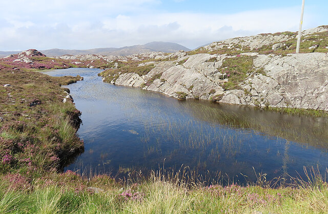
Loch Fhleoideabhaigh, commonly known as Fhleoideabhaigh Loch, is a picturesque freshwater loch located in the scenic Inverness-shire region of Scotland. Nestled amidst the breathtaking Highland landscape, this secluded body of water offers a tranquil haven for nature enthusiasts and outdoor lovers alike.

Stretching over an area of approximately 2 square kilometers, Loch Fhleoideabhaigh boasts crystal-clear waters that are renowned for their purity. The loch is fed by several small streams and springs, ensuring a constant flow of fresh, untainted water. Surrounded by rolling hills and scattered woodlands, the loch's shores provide a peaceful retreat for visitors seeking solace in nature.

The diverse ecosystem of Loch Fhleoideabhaigh supports a rich array of flora and fauna. The surrounding marshes and wetland areas are home to a variety of water-loving plants, including reeds, rushes, and water lilies. These lush vegetation areas provide an ideal habitat for a myriad of bird species, such as ducks, swans, and herons, making it a popular destination for birdwatching enthusiasts.

The loch also presents opportunities for various recreational activities. Anglers can indulge in the pursuit of trout, salmon, and char, as Loch Fhleoideabhaigh is known for its abundant fish population. Additionally, the calm waters of the loch offer a serene setting for kayaking, canoeing, and paddleboarding, allowing visitors to explore its beauty from a different perspective.

In summary, Loch Fhleoideabhaigh in Inverness-shire is a captivating freshwater loch that captivates visitors with its unspoiled beauty and serene ambiance. With its diverse ecosystem, pristine waters, and surrounding natural wonders, it is a haven for nature lovers and outdoor enthusiasts seeking solace in the Scottish Highlands.

If you have any feedback on the listing, please let us know in the comments section below.

Loch Fhleoideabhaigh Images

Images are sourced within 2km of 57.793418/-6.8846498 or Grid Reference NG0988. Thanks to Geograph Open Source API. All images are credited.

Fish Farm Pier at Loch Huamabhat
Solitary White house Geocaching is a type of global treasure hunt of people looking for caches, or hidden stashes of objects. Geocaching may also be described as a series of hide-and-seek games, where hiders provide online clues for seekers. Seekers use global positioning system (GPS) devices to find hidden caches
Solitary White house
Geocaching is a type of global treasure hunt of people looking for caches, or hidden stashes of objects. Geocaching may also be described as a series of hide-and-seek games, where hiders provide online clues for seekers. Seekers use global positioning system (GPS) devices to find hidden caches
Flodabay postbox Geocaching is a type of global treasure hunt of people looking for caches, or hidden stashes of objects. Geocaching may also be described as a series of hide-and-seek games, where hiders provide online clues for seekers. Seekers use global positioning system (GPS) devices to find hidden caches
Flodabay postbox
Geocaching is a type of global treasure hunt of people looking for caches, or hidden stashes of objects. Geocaching may also be described as a series of hide-and-seek games, where hiders provide online clues for seekers. Seekers use global positioning system (GPS) devices to find hidden caches
Loch Huamabhat One of the larger lochans in the wilderness of East Harris.
Loch Huamabhat
One of the larger lochans in the wilderness of East Harris.
Fishing Station? It's not immediately obvious what the reason for the large raft and jetties is.
Fishing Station?
It's not immediately obvious what the reason for the large raft and jetties is.
Cnoc and Lochan Topography The Lewisian gneiss typically produces topography with knolls or rocks interspersed with hollows that are occupied by small lochs. In geography and geology this is described as Cnoc and lochan topography.
Cnoc and Lochan Topography
The Lewisian gneiss typically produces topography with knolls or rocks interspersed with hollows that are occupied by small lochs. In geography and geology this is described as Cnoc and lochan topography.
Loch Buaile Cairistiona Mhurchaidh This rather cumbersome name for a very small loch means something like 'loch of Christina Murdoch's cattle fold'.
Loch Buaile Cairistiona Mhurchaidh
This rather cumbersome name for a very small loch means something like 'loch of Christina Murdoch's cattle fold'.
Church welcome sign A stone "noticeboard" on the side of the main road through Manish, inviting you to the Church of Scotland
Church welcome sign
A stone "noticeboard" on the side of the main road through Manish, inviting you to the Church of Scotland
Inlet of Loch Gheocrab
Turning for Aird Shleibhe
Unnamed Lochan on Flodabay Point Should have put my boots on for this one! Very wet underfoot
Unnamed Lochan on Flodabay Point
Should have put my boots on for this one! Very wet underfoot
House around Ob Leasaid near Manais Old and new houses around Ob Leasaid - a typical inlet in the Bays area of South Harris
House around Ob Leasaid near Manais
Old and new houses around Ob Leasaid - a typical inlet in the Bays area of South Harris
Old school at Manais
Shed at Manais The wood carving looks to be a copy of one of the Lewis Chessmen. The sign to the right of the carving has been taken? borrowed? nicked? from the Roghadal Hotel.
Shed at Manais
The wood carving looks to be a copy of one of the Lewis Chessmen. The sign to the right of the carving has been taken? borrowed? nicked? from the Roghadal Hotel.
Part of the Golden Road at Manais
Old school and Telephone box at Manais
Ob Leasaid At Manais
Ob Leasaid
At Manais
Cairn above Manais
Cairn above Manais
Show me another place!

Loch Fhleoideabhaigh is located at Grid Ref: NG0988 (Lat: 57.793418, Lng: -6.8846498)

Unitary Authority: Na h-Eileanan an Iar

Police Authority: Highlands and Islands

What 3 Words

///exit.scornful.leathers. Near Leverburgh, Na h-Eileanan Siar

Related Wikis

Borsham

Borsham (Scottish Gaelic: Boirseam) is a village in the 'Bays' area of Harris in the Outer Hebrides, Scotland. Borsham is within the parish of Harris....

Stockinish Island

Stockinish Island (Scottish Gaelic: Eilean Stocainis) is an uninhabited island off Harris, in the Outer Hebrides. == Geography and geology == Stockinish...

Lingarabay

Lingarabay (also Lingerabay or Lingerbay; Scottish Gaelic: Lingreabhagh) is a small coastal settlement on Harris, in the Outer Hebrides of Scotland. It...

Harris Superquarry

The Harris Super Quarry was a super quarry at Lingerbay, Harris, Scotland proposed by Redland Aggregates in 1991. The plan was to surface mine aggregate...

Nearby Amenities

Located within 500m of 57.793418,-6.8846498
Passing Place
Lat/Long: 57.7916313/-6.8897148
Passing Place
Lat/Long: 57.7933385/-6.8882279
Post Box
Source: survey
Lat/Long: 57.7949853/-6.8848363
Bus Stop
Flodabay
Naptan AtcoCode: 6010731652
Naptan Bearing: S
Naptan CommonName: Flodabay
Naptan Indicator: Village
Naptan Landmark: Village
Naptan NaptanCode: 94723628
Naptan Street: Village
Naptan Verified: no
Source: naptan_import
Lat/Long: 57.7950807/-6.8847505
Fleòideabhagh
Name En: Flodabay
Name Gd: Fleòideabhagh
Place: hamlet
Lat/Long: 57.7948017/-6.8852351
Passing Place
Lat/Long: 57.7944713/-6.8860688
Passing Place
Lat/Long: 57.7912438/-6.8907187
Passing Place
Lat/Long: 57.7921082/-6.8889452
Passing Place
Lat/Long: 57.7928142/-6.8889826
Passing Place
Lat/Long: 57.7933855/-6.8873213
Material: wood
Power: pole
Lat/Long: 57.7934714/-6.8881872
Passing Place
Lat/Long: 57.7971389/-6.8839712
Passing Place
Lat/Long: 57.7949855/-6.8847202
Material: wood
Power: pole
Lat/Long: 57.7957861/-6.8849249
Material: wood
Power: pole
Lat/Long: 57.7965152/-6.8849286
Material: wood
Power: pole
Lat/Long: 57.7974209/-6.8849662
Material: wood
Power: pole
Lat/Long: 57.7947648/-6.8858538
Material: wood
Power: pole
Lat/Long: 57.795318/-6.8854837
Material: wood
Power: pole
Lat/Long: 57.7935226/-6.8858083
Material: wood
Power: pole
Lat/Long: 57.7939115/-6.8856662
Loch Fhleoideabhaigh
Natural: bay
Lat/Long: 57.7909599/-6.8833233
Material: wood
Power: pole
Lat/Long: 57.7924265/-6.8904525
Material: wood
Power: pole
Lat/Long: 57.7916353/-6.8922174
Material: wood
Power: pole
Lat/Long: 57.7941948/-6.8853569
Power: pole
Lat/Long: 57.7928085/-6.8896244
Power: pole
Lat/Long: 57.7916223/-6.8883679
Power: pole
Lat/Long: 57.791248/-6.887975
Power: pole
Lat/Long: 57.7903181/-6.8869847
Power: pole
Lat/Long: 57.7907886/-6.8874903
Power: pole
Lat/Long: 57.7897581/-6.8863848
Power: pole
Lat/Long: 57.7890948/-6.8856775
Material: wood
Power: pole
Lat/Long: 57.7922338/-6.8890045
Power: pole
Lat/Long: 57.79211/-6.8911586
Passing Place
Lat/Long: 57.7936878/-6.8815589
Passing Place
Lat/Long: 57.7945149/-6.8830819
The data included in this document is from www.openstreetmap.org. The data is made available under ODbL.

Have you been to Loch Fhleoideabhaigh?

Leave your review of Loch Fhleoideabhaigh below (or comments, questions and feedback).