Loch Dubh Heillihope

Lake, Pool, Pond, Freshwater Marsh in Inverness-shire

Scotland

Loch Dubh Heillihope

Ruin at Ardvey Abandoned and derelict, in spite of being relatively modern.
Ruin at Ardvey Credit: Richard Dorrell

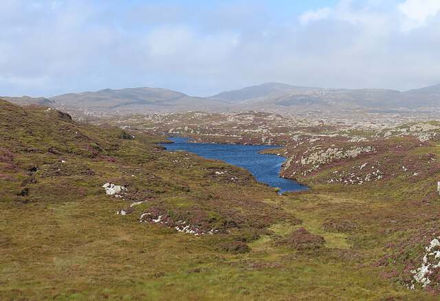
Loch Dubh Heillihope is a freshwater lake located in Inverness-shire, Scotland. The lake is surrounded by rolling hills and lush greenery, creating a picturesque and serene setting for visitors to enjoy. Loch Dubh Heillihope is known for its clear, calm waters, which make it a popular spot for fishing and boating.

The lake is home to a variety of freshwater fish species, including trout and perch, making it a prime destination for anglers looking to reel in a big catch. The surrounding marshland is also teeming with wildlife, providing ample opportunities for birdwatching and nature enthusiasts.

The peaceful atmosphere of Loch Dubh Heillihope makes it a popular spot for picnicking, hiking, and simply enjoying the natural beauty of the Scottish Highlands. Visitors can take in stunning views of the surrounding landscape from the shores of the lake, or explore the nearby walking trails that wind through the surrounding countryside.

Overall, Loch Dubh Heillihope offers a tranquil escape from the hustle and bustle of everyday life, making it a must-visit destination for those seeking a peaceful retreat in the heart of the Scottish countryside.

If you have any feedback on the listing, please let us know in the comments section below.

Loch Dubh Heillihope Images

Images are sourced within 2km of 57.783072/-6.902079 or Grid Reference NG0887. Thanks to Geograph Open Source API. All images are credited.

Ruin at Ardvey Abandoned and derelict, in spite of being relatively modern.
Ruin at Ardvey
Abandoned and derelict, in spite of being relatively modern.
Loch Fhionnsabhaigh The blue pay-to-view telescope is probably there to enable seal-watchers to get a closer view - though as the seals were today basking on rocks just a few yards from the shore, the scope was barely necessary.
See also: <a href="https://www.geograph.org.uk/photo/7033022">NG0887 : Common seals in Loch Fhionnsabhaigh</a>.
Loch Fhionnsabhaigh
The blue pay-to-view telescope is probably there to enable seal-watchers to get a closer view - though as the seals were today basking on rocks just a few yards from the shore, the scope was barely necessary. See also: NG0887 : Common seals in Loch Fhionnsabhaigh.
Common seals in Loch Fhionnsabhaigh A slightly zoomed-in image, taken from the shore of the loch.
Common seals in Loch Fhionnsabhaigh
A slightly zoomed-in image, taken from the shore of the loch.
The road approaching Fionnsabhagh from the south
Fish Farm Pier at Loch Huamabhat
Desolate inland Harris Geocaching is a type of global treasure hunt of people looking for caches, or hidden stashes of objects. Geocaching may also be described as a series of hide-and-seek games, where hiders provide online clues for seekers. Seekers use global positioning system (GPS) devices to find hidden caches
Desolate inland Harris
Geocaching is a type of global treasure hunt of people looking for caches, or hidden stashes of objects. Geocaching may also be described as a series of hide-and-seek games, where hiders provide online clues for seekers. Seekers use global positioning system (GPS) devices to find hidden caches
Solitary White house Geocaching is a type of global treasure hunt of people looking for caches, or hidden stashes of objects. Geocaching may also be described as a series of hide-and-seek games, where hiders provide online clues for seekers. Seekers use global positioning system (GPS) devices to find hidden caches
Solitary White house
Geocaching is a type of global treasure hunt of people looking for caches, or hidden stashes of objects. Geocaching may also be described as a series of hide-and-seek games, where hiders provide online clues for seekers. Seekers use global positioning system (GPS) devices to find hidden caches
Flodabay postbox Geocaching is a type of global treasure hunt of people looking for caches, or hidden stashes of objects. Geocaching may also be described as a series of hide-and-seek games, where hiders provide online clues for seekers. Seekers use global positioning system (GPS) devices to find hidden caches
Flodabay postbox
Geocaching is a type of global treasure hunt of people looking for caches, or hidden stashes of objects. Geocaching may also be described as a series of hide-and-seek games, where hiders provide online clues for seekers. Seekers use global positioning system (GPS) devices to find hidden caches
Loch an Luig One of the hundreds of small lochs among the gneiss of eastern Harris.
Loch an Luig
One of the hundreds of small lochs among the gneiss of eastern Harris.
Loch Sgùrr The road is right on the brink of this small lochan.
Loch Sgùrr
The road is right on the brink of this small lochan.
Fionnsabhaigh Finsbay is one of the scattered villages on the east side of Harris, settled by people evicted from the fertile machair land on the west during the Highand Clearances.
Fionnsabhaigh
Finsbay is one of the scattered villages on the east side of Harris, settled by people evicted from the fertile machair land on the west during the Highand Clearances.
Finsbay One of a handful of small settlements in Eastern Harris.
Finsbay
One of a handful of small settlements in Eastern Harris.
Sea Inlet at Ardvey Marked on the map as a tidal pond, this is connected to the sea on the right, beyond the narrowest part. It is, unfortunately, difficult to photograph anything in this area without including the necessary evil of power lines.
Sea Inlet at Ardvey
Marked on the map as a tidal pond, this is connected to the sea on the right, beyond the narrowest part. It is, unfortunately, difficult to photograph anything in this area without including the necessary evil of power lines.
Tidal Inlet at Aird Mhighe The inlet is in this square but the house is in the next square.
Tidal Inlet at Aird Mhighe
The inlet is in this square but the house is in the next square.
Loch Fhionnsabhaigh One of the larger sea-lochs on the east coast of Harris.
Loch Fhionnsabhaigh
One of the larger sea-lochs on the east coast of Harris.
Loch Holmasaig A small lochan, one of dozens alongside the Bays road.
Loch Holmasaig
A small lochan, one of dozens alongside the Bays road.
Loch Huamabhat One of the larger lochans in the wilderness of East Harris.
Loch Huamabhat
One of the larger lochans in the wilderness of East Harris.
Fishing Station? It's not immediately obvious what the reason for the large raft and jetties is.
Fishing Station?
It's not immediately obvious what the reason for the large raft and jetties is.
Show me another place!

Loch Dubh Heillihope is located at Grid Ref: NG0887 (Lat: 57.783072, Lng: -6.902079)

Unitary Authority: Na h-Eileanan an Iar

Police Authority: Highlands and Islands

What 3 Words

///unopposed.instance.petal. Near Leverburgh, Na h-Eileanan Siar

Related Wikis

Borsham

Borsham (Scottish Gaelic: Boirseam) is a village in the 'Bays' area of Harris in the Outer Hebrides, Scotland. Borsham is within the parish of Harris....

Lingarabay

Lingarabay (also Lingerabay or Lingerbay; Scottish Gaelic: Lingreabhagh) is a small coastal settlement on Harris, in the Outer Hebrides of Scotland. It...

Harris Superquarry

The Harris Super Quarry was a super quarry at Lingerbay, Harris, Scotland proposed by Redland Aggregates in 1991. The plan was to surface mine aggregate...

Roineabhal

Roineabhal is a hill in Harris, in the Western Isles of Scotland. The granite on the summit plateau of the mountain is anorthosite, and is similar in composition...

Nearby Amenities

Located within 500m of 57.783072,-6.902079
Passing Place
Lat/Long: 57.7851689/-6.9093617
Passing Place
Lat/Long: 57.7848919/-6.9058951
Passing Place
Lat/Long: 57.7853806/-6.9035515
Passing Place
Lat/Long: 57.7858488/-6.9019112
Cuidhtinis
Alt Name En: Quidnish
Alt Name Gd: Cuidhinis
Is In: Na Hearadh
Name En: Quidinish
Name Gd: Cuidhtinis
Place: hamlet
Lat/Long: 57.7813884/-6.9021565
Barrier: cattle_grid
Source: survey
Lat/Long: 57.7821536/-6.9050082
Passing Place
Lat/Long: 57.7855727/-6.9000682
Passing Place
Lat/Long: 57.7850444/-6.9043455
Passing Place
Lat/Long: 57.7848994/-6.9073413
Passing Place
Lat/Long: 57.7809062/-6.9020877
Material: wood
Power: pole
Lat/Long: 57.7857755/-6.9026512
Material: wood
Power: pole
Lat/Long: 57.785358/-6.9048989
Material: wood
Power: pole
Lat/Long: 57.7853909/-6.9068247
Material: wood
Power: pole
Lat/Long: 57.7854295/-6.9077044
Material: wood
Power: pole
Lat/Long: 57.7870838/-6.9021737
Material: wood
Power: pole
Lat/Long: 57.7833873/-6.9006313
Material: wood
Power: pole
Lat/Long: 57.7816127/-6.9028388
Material: wood
Power: pole
Lat/Long: 57.784359/-6.9004449
Material: wood
Power: pole
Lat/Long: 57.7849649/-6.9014038
Material: wood
Power: pole
Lat/Long: 57.7855969/-6.9023506
Material: wood
Power: pole
Lat/Long: 57.7826741/-6.901605
Material: wood
Power: pole
Lat/Long: 57.7821207/-6.9040833
Material: wood
Power: pole
Lat/Long: 57.7819334/-6.9048478
Material: wood
Power: pole
Lat/Long: 57.7824082/-6.903284
Material: wood
Power: pole
Lat/Long: 57.7818219/-6.9033618
Material: wood
Power: pole
Lat/Long: 57.7820335/-6.9056685
Material: wood
Power: pole
Lat/Long: 57.7821207/-6.9064866
Material: wood
Power: pole
Lat/Long: 57.7822194/-6.9074066
Material: wood
Power: pole
Lat/Long: 57.7824782/-6.9081362
Material: wood
Power: pole
Lat/Long: 57.7827242/-6.9088469
Material: wood
Power: pole
Lat/Long: 57.7829415/-6.9092198
Material: wood
Power: pole
Lat/Long: 57.783269/-6.9097562
Material: wood
Power: pole
Lat/Long: 57.7836336/-6.9103651
Power: pole
Lat/Long: 57.7813723/-6.8950089
Power: pole
Lat/Long: 57.7819232/-6.8955573
Power: pole
Lat/Long: 57.7825159/-6.89616
Power: pole
Lat/Long: 57.7831066/-6.8967402
Power: pole
Lat/Long: 57.7831884/-6.8976629
Power: pole
Lat/Long: 57.7832872/-6.8987915
Power: pole
Lat/Long: 57.783814/-6.8996
Power: pole
Lat/Long: 57.7800658/-6.8965714
Power: pole
Lat/Long: 57.7799076/-6.8969448
Power: pole
Lat/Long: 57.7797695/-6.8972919
Power: pole
Lat/Long: 57.7795195/-6.8978961
Power: pole
Lat/Long: 57.7797694/-6.8985291
Power: pole
Lat/Long: 57.7803964/-6.8973915
Power: pole
Lat/Long: 57.7803545/-6.9008933
Power: pole
Lat/Long: 57.780582/-6.9013724
Power: pole
Lat/Long: 57.7808016/-6.9018927
Power: pole
Lat/Long: 57.7812087/-6.9023606
Passing Place
Lat/Long: 57.7798697/-6.8971257
Heillihope
Place: locality
Lat/Long: 57.7792308/-6.8981431
Holmasaig
Place: locality
Lat/Long: 57.7840128/-6.9101916
Passing Place
Lat/Long: 57.780159/-6.8992486
The data included in this document is from www.openstreetmap.org. The data is made available under ODbL.

Have you been to Loch Dubh Heillihope?

Leave your review of Loch Dubh Heillihope below (or comments, questions and feedback).