Burrow Head

Coastal Feature, Headland, Point in Wigtownshire

Scotland

Burrow Head

Old Boundary Marker near Burrow Head, Dumfries and Galloway War Department Boundary Marker on the cliff top northwest of Burrow Head Holiday Farm and 1000 metres south of Tonderghie. Formerly in Whithorn parish, Wigtownshire, now Dumfries and Galloway. It marks the boundary of Burrow Head heavy anti-aircraft practice battery and domestic site, see <span class="nowrap"><a title="https://canmore.org.uk/site/146537/burrow-head-heavy-anti-aircraft-practice-battery-and-domestic-site" rel="nofollow ugc noopener" href="https://canmore.org.uk/site/146537/burrow-head-heavy-anti-aircraft-practice-battery-and-domestic-site">Link</a><img style="margin-left:2px;" alt="External link" title="External link - shift click to open in new window" src="https://s1.geograph.org.uk/img/external.png" width="10" height="10"/></span>.

Milestone Society National ID: WT_WDWHIT01em
Old Boundary Marker near Burrow Head, Dumfries and Galloway Credit: M Hatton

Burrow Head is a prominent headland located in Wigtownshire, Scotland. Situated on the southernmost tip of the Rhins of Galloway peninsula, it overlooks the Irish Sea and offers stunning coastal views. This rugged and picturesque headland is a popular destination for nature enthusiasts, hikers, and birdwatchers.

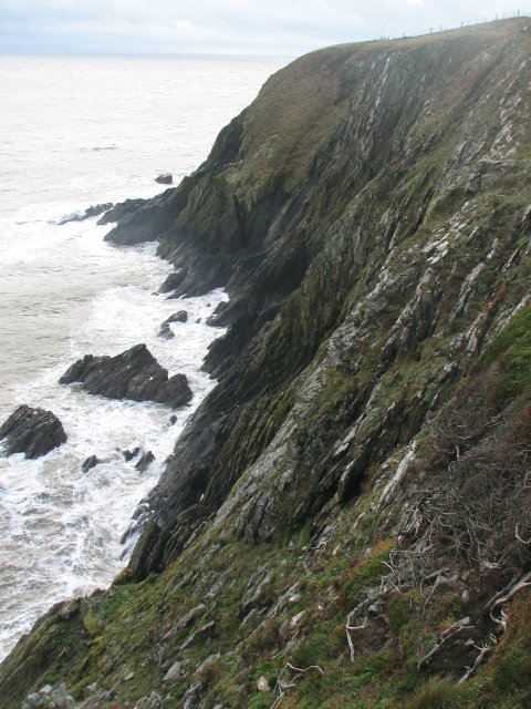
The headland is characterized by towering cliffs that reach heights of up to 80 meters (262 feet) in some areas. These cliffs are composed of sedimentary rock formations, showcasing layers of sandstone and limestone that have been shaped by the relentless pounding of the waves over thousands of years. The resulting jagged and dramatic coastline is a testament to the power of erosion.

Burrow Head is also home to a variety of wildlife, making it a designated Site of Special Scientific Interest (SSSI). Visitors can spot numerous seabirds, including guillemots, razorbills, and kittiwakes, nesting along the cliffs. Dolphins and porpoises can sometimes be seen swimming offshore, adding to the area's natural charm.

The headland is easily accessible via a coastal footpath that winds its way through the surrounding farmland. This path offers breathtaking vistas of the surrounding countryside and the sea, providing ample opportunities for photography and exploration.

For those interested in history, Burrow Head is also home to Burrow Head Lighthouse, which was built in 1813 to guide ships navigating the treacherous waters off the coast. The lighthouse is now automated and no longer open to the public, but its presence adds a touch of maritime history to the area.

Overall, Burrow Head is a captivating coastal feature that offers visitors a chance to experience the wild beauty of Scotland's coastline while immersing themselves in its rich natural and historical heritage.

If you have any feedback on the listing, please let us know in the comments section below.

Burrow Head Images

Images are sourced within 2km of 54.677957/-4.3930294 or Grid Reference NX4534. Thanks to Geograph Open Source API. All images are credited.

Old Boundary Marker near Burrow Head, Dumfries and Galloway War Department Boundary Marker on the cliff top northwest of Burrow Head Holiday Farm and 1000 metres south of Tonderghie. Formerly in Whithorn parish, Wigtownshire, now Dumfries and Galloway. It marks the boundary of Burrow Head heavy anti-aircraft practice battery and domestic site, see <span class="nowrap"><a title="https://canmore.org.uk/site/146537/burrow-head-heavy-anti-aircraft-practice-battery-and-domestic-site" rel="nofollow ugc noopener" href="https://canmore.org.uk/site/146537/burrow-head-heavy-anti-aircraft-practice-battery-and-domestic-site">Link</a><img style="margin-left:2px;" alt="External link" title="External link - shift click to open in new window" src="https://s1.geograph.org.uk/img/external.png" width="10" height="10"/></span>.

Milestone Society National ID: WT_WDWHIT01em
Old Boundary Marker near Burrow Head, Dumfries and Galloway
War Department Boundary Marker on the cliff top northwest of Burrow Head Holiday Farm and 1000 metres south of Tonderghie. Formerly in Whithorn parish, Wigtownshire, now Dumfries and Galloway. It marks the boundary of Burrow Head heavy anti-aircraft practice battery and domestic site, see LinkExternal link. Milestone Society National ID: WT_WDWHIT01em
Morrach Farm buildings viewed from the track leading past Orfasey.
Morrach
Farm buildings viewed from the track leading past Orfasey.
The Lick Coastline near Burrow Head.
The Lick
Coastline near Burrow Head.
Coastal path, Burrow Head Looking west from close to Burrow Head.  The land visible in the distance is the Mull of Galloway.
Coastal path, Burrow Head
Looking west from close to Burrow Head. The land visible in the distance is the Mull of Galloway.
Stank Rocky promontory by the Burrow Head Holiday Farm, marked as Stank on the Explorer map.
Stank
Rocky promontory by the Burrow Head Holiday Farm, marked as Stank on the Explorer map.
Cutcloy Farm buildings at Cutcloy.
Cutcloy
Farm buildings at Cutcloy.
Jamies's Hole Deep cave in the foot of the cliffs near Burrow Head.
Jamies's Hole
Deep cave in the foot of the cliffs near Burrow Head.
Cairn, Burrow Head Looking north from the high point of land at Burrow Head.  The lochan is not named.
Cairn, Burrow Head
Looking north from the high point of land at Burrow Head. The lochan is not named.
Burrowhead - Sea Cliffs To the west of the campsite at Burrowhead. There are the remains of war time gun emplacements and other buildings around this area.
Burrowhead - Sea Cliffs
To the west of the campsite at Burrowhead. There are the remains of war time gun emplacements and other buildings around this area.
Isle of Man from Burrow Head The outline of the Isle of Man can be made out amongst the clouds on the horizon. At night several different lighthouse beacons can be seen flashing.
Isle of Man from Burrow Head
The outline of the Isle of Man can be made out amongst the clouds on the horizon. At night several different lighthouse beacons can be seen flashing.
The east side of Broom Point Photographed from the nearest section of the cliff path above the point, without falling too far down the cliffs.
The east side of Broom Point
Photographed from the nearest section of the cliff path above the point, without falling too far down the cliffs.
The south side of Broom Point
Towards Burrow Head from Clachanlaukes A well-built dry-stane dyke keeps the cattle in the fields, and prevents them from wandering up onto the higher cliffs further to the southwest.
Towards Burrow Head from Clachanlaukes
A well-built dry-stane dyke keeps the cattle in the fields, and prevents them from wandering up onto the higher cliffs further to the southwest.
Along The Lick towards Thief's Hole
The Lick from the clifftop coastal path
A chasm just northeast of Thief's Hole A narrow inlet in the steep cliffs along this section of the coast.
A chasm just northeast of Thief's Hole
A narrow inlet in the steep cliffs along this section of the coast.
Thief's Hole from the west A small cave in the cliffs near Burrow Head; the name suggests it played a part in smuggling operations.
Thief's Hole from the west
A small cave in the cliffs near Burrow Head; the name suggests it played a part in smuggling operations.
Rocks at Burrow Head Sedimentary rocks (greywacke, I believe) are tilted moreor less vertically here in the area just east of Burrow Head. The overall effect is almost identical to the columnar basalt formations such as those on Staffa and at the Antrim Giant's Causeway.
Rocks at Burrow Head
Sedimentary rocks (greywacke, I believe) are tilted moreor less vertically here in the area just east of Burrow Head. The overall effect is almost identical to the columnar basalt formations such as those on Staffa and at the Antrim Giant's Causeway.
Show me another place!

Burrow Head is located at Grid Ref: NX4534 (Lat: 54.677957, Lng: -4.3930294)

Unitary Authority: Dumfries and Galloway

Police Authority: Dumfries and Galloway

What 3 Words

///remarried.corrosive.boomers. Near Whithorn, Dumfries & Galloway

Nearby Locations

Ducker Rock Burrow Head

Related Wikis

Burrow Head

Burrow Head is a headland located approximately two miles south-west of Isle of Whithorn, Wigtownshire, Scotland, and is the second southernmost point...

Isle of Whithorn

Isle of Whithorn (Port Rosnait in Gaelic) is one of the most southerly villages and seaports in Scotland, lying on the coast north east of Burrow Head...

St Ninian's Cave

St Ninian's Cave is a cave in Physgill Glen, Whithorn, Dumfries and Galloway, Scotland. It features in the climax of the acclaimed 1973 horror film The...

Glasserton

Glasserton is a civil parish in Dumfries and Galloway, south-west Scotland. It is on the Machars peninsula, in the traditional county of Wigtownshire....

Candida Casa

Candida Casa was the name given to the church established by St Ninian in Whithorn, Galloway, southern Scotland, in the mid fifth century AD. The name...

Whithorn Priory

Whithorn Priory was a medieval Scottish monastery that also served as a cathedral, located at 6 Bruce Street in Whithorn, Wigtownshire, Dumfries and Galloway...

Whithorn

Whithorn (Scots pronunciation: [ˈʍɪthorn], Taigh Mhàrtainn in modern Gaelic), is a royal burgh in the historic county of Wigtownshire in Dumfries and Galloway...

Rispain Camp

Rispain Camp is the remains of a fortified farmstead 1 mile west of Whithorn, Dumfries and Galloway, Scotland. It is one of the major Iron Age archaeological...

Nearby Amenities

Located within 500m of 54.677957,-4.3930294
Source: PGS
Lat/Long: 54.67741/-4.391596
Source: PGS
Lat/Long: 54.677541/-4.39138
Source: PGS
Lat/Long: 54.678056/-4.391176
Source: PGS
Lat/Long: 54.678198/-4.389855
Source: PGS
Lat/Long: 54.678469/-4.388538
Source: PGS
Lat/Long: 54.67848/-4.387654
Source: PGS
Lat/Long: 54.678267/-4.387357
Source: PGS
Lat/Long: 54.678101/-4.387199
Source: PGS
Lat/Long: 54.678106/-4.386757
Source: PGS
Lat/Long: 54.678362/-4.386766
Source: PGS
Lat/Long: 54.678446/-4.38706
Source: PGS
Lat/Long: 54.678872/-4.387005
Source: PGS
Lat/Long: 54.67782/-4.400451
Source: PGS
Lat/Long: 54.677846/-4.398241
Source: PGS
Lat/Long: 54.677984/-4.397362
Source: PGS
Lat/Long: 54.677472/-4.397344
Source: PGS
Lat/Long: 54.67761/-4.396465
Source: PGS
Lat/Long: 54.677741/-4.396249
Source: PGS
Lat/Long: 54.677871/-4.396032
Source: PGS
Lat/Long: 54.677876/-4.39559
Source: PGS
Lat/Long: 54.677751/-4.395366
Source: PGS
Lat/Long: 54.677244/-4.394906
Source: PGS
Lat/Long: 54.677118/-4.39468
Source: PGS
Lat/Long: 54.677133/-4.393355
Burrow Heid
Name En: Burrow Head
Natural: cape
Wikidata: Q5000496
Wikipedia: en:Burrow Head
Lat/Long: 54.6776002/-4.3931439
The data included in this document is from www.openstreetmap.org. The data is made available under ODbL.

Have you been to Burrow Head?

Leave your review of Burrow Head below (or comments, questions and feedback).