An Fhaighear Mhòir

Coastal Feature, Headland, Point in Ross-shire

Scotland

An Fhaighear Mhòir

Landing On Sgeir an Araig Our landing point on the NE of Sgeir an Araig to bag the trig point.
Landing On Sgeir an Araig Credit: Rude Health

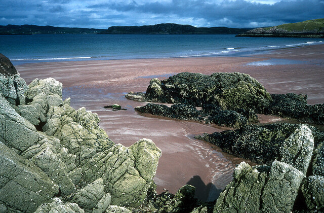
An Fhaighear Mhòir, also known as The Great Feathers, is a prominent coastal feature located in Ross-shire, Scotland. Situated on the west coast of the Scottish Highlands, it is a magnificent headland that stretches out into the North Atlantic Ocean. The Gaelic name "An Fhaighear Mhòir" translates to "the great sea cliff," aptly describing its towering cliffs that rise dramatically from the sea.

This headland is a popular destination for nature enthusiasts and hikers due to its stunning natural beauty. The rugged coastline is characterized by steep cliffs, with the highest point reaching approximately 200 meters above sea level. From the top, visitors are treated to breathtaking panoramic views of the surrounding waters and nearby islands, such as the Isle of Skye.

The area surrounding An Fhaighear Mhòir is abundant in diverse marine life, making it a prime spot for birdwatching and wildlife observation. Seabirds like puffins, guillemots, and razorbills can be spotted nesting on the cliffs, while seals and dolphins are often seen swimming in the waters below. The headland is also blessed with rich flora, including heather, gorse, and wildflowers, adding vibrant splashes of color to the rugged landscape.

In addition to its natural wonders, An Fhaighear Mhòir holds historical significance. The headland is home to ancient ruins and archaeological sites, with traces of human habitation dating back thousands of years. These remnants offer a glimpse into the lives of early settlers and the rich cultural heritage of the region.

Overall, An Fhaighear Mhòir is a captivating coastal feature that combines stunning natural landscapes, diverse wildlife, and a rich history, making it a must-visit destination for anyone exploring the beauty of Ross-shire in Scotland.

If you have any feedback on the listing, please let us know in the comments section below.

An Fhaighear Mhòir Images

Images are sourced within 2km of 57.831287/-5.6694806 or Grid Reference NG8288. Thanks to Geograph Open Source API. All images are credited.

Landing On Sgeir an Araig Our landing point on the NE of Sgeir an Araig to bag the trig point.
Landing On Sgeir an Araig
Our landing point on the NE of Sgeir an Araig to bag the trig point.
Firemore Beach on the side of Loch Ewe Rich red sand.
Firemore Beach on the side of Loch Ewe
Rich red sand.
B8057 near Poolewe, Scottish Highlands
Loch Sguod from the path to Camas Mor Loch Ewe (sea loch) lies beyond.
Loch Sguod from the path to Camas Mor
Loch Ewe (sea loch) lies beyond.
Camas na Muic and the beach at Firemore
Uidh Chrò - the outflow from Loch Sguod
Lifebelt at Camas na Muic, Firemore
Buildings at Coast, Inverasdale In the distance, beyond Loch Ewe, the mountains of the Fisherfield Forest.
Buildings at Coast, Inverasdale
In the distance, beyond Loch Ewe, the mountains of the Fisherfield Forest.
Cottage near Cove, Poolewe Picture was taken from the pebble beach below this holiday cottage on the shores of Loch Ewe. Memorable because it was taken the day Princess Diana died
Cottage near Cove, Poolewe
Picture was taken from the pebble beach below this holiday cottage on the shores of Loch Ewe. Memorable because it was taken the day Princess Diana died
Sheep pens at Firemore
Firemore beach
Firemore beach
Rough land at Coast
Rough land at Coast
Firemore beach
Firemore beach
Foam spiral on Loch Sguod A very slight breeze was forming the foam along the beach into a spiral.
Foam spiral on Loch Sguod
A very slight breeze was forming the foam along the beach into a spiral.
Dwellings at Mellangaun
Mellangaun Mostly peat bog in the foreground.
Mellangaun
Mostly peat bog in the foreground.
The beach at Firemore At low tide a great sandy beach to explore.
The beach at Firemore
At low tide a great sandy beach to explore.
Bridge over Uidh Chro Carrying the B8057.

Uidh is gaelic for slowly moving water.
Bridge over Uidh Chro
Carrying the B8057. Uidh is gaelic for slowly moving water.
Show me another place!

An Fhaighear Mhòir is located at Grid Ref: NG8288 (Lat: 57.831287, Lng: -5.6694806)

Unitary Authority: Highland

Police Authority: Highlands and Islands

What 3 Words

///fancy.eyelashes.hissing. Near Gairloch, Highland

Related Wikis

Cove, Highland

Cove is a remote hamlet located on the northwestern shore of the sea loch Loch Ewe, and 8 mi (13 km) northwest of Poolewe in Ross-shire, Scottish Highlands...

Inverasdale

Inverasdale (Scottish Gaelic: Inbhir Àsdail) is a hamlet in the Northwest Highlands of Scotland, located by Loch Ewe, in the region of Wester Ross. �...

Isle of Ewe

The Isle of Ewe (Scottish Gaelic: Eilean Iùbh) is a small Scottish island on the west coast of Ross and Cromarty. The island is inhabited by a single family...

Loch Ewe

Loch Ewe (Scottish Gaelic: Loch Iùbh) is a sea loch in the region of Wester Ross in the Northwest Highlands of Scotland. The shores are inhabited by a...

Nearby Amenities

Located within 500m of 57.831287,-5.6694806
Source: PGS
Lat/Long: 57.8269563/-5.6681706
Source: PGS
Lat/Long: 57.8268454/-5.6686357
Source: PGS
Lat/Long: 57.8272704/-5.669481
Source: PGS
Lat/Long: 57.8279262/-5.6699512
Source: PGS
Lat/Long: 57.8284891/-5.6699908
Created By: almien_coastlines
Source: PGS
Lat/Long: 57.828737/-5.669864
Created By: almien_coastlines
Source: PGS
Lat/Long: 57.82887/-5.669633
Source: PGS
Lat/Long: 57.82902/-5.6677442
Created By: almien_coastlines
Source: PGS
Lat/Long: 57.82891/-5.667716
Source: PGS
Lat/Long: 57.8289089/-5.6673667
Source: PGS
Lat/Long: 57.8291689/-5.6670893
Created By: almien_coastlines
Source: PGS
Lat/Long: 57.829309/-5.667026
Source: PGS
Lat/Long: 57.8294909/-5.6667931
Source: PGS
Lat/Long: 57.8299481/-5.6669513
Created By: almien_coastlines
Source: PGS
Lat/Long: 57.830332/-5.667101
Created By: almien_coastlines
Source: PGS
Lat/Long: 57.831099/-5.667158
Source: PGS
Lat/Long: 57.8316286/-5.6671231
Created By: almien_coastlines
Source: PGS
Lat/Long: 57.832122/-5.667234
Source: PGS
Lat/Long: 57.8324077/-5.6676484
Source: PGS
Lat/Long: 57.8325042/-5.6680903
Source: PGS
Lat/Long: 57.8329553/-5.6690847
Source: PGS
Lat/Long: 57.8328472/-5.6698971
Source: PGS
Lat/Long: 57.8319988/-5.6707283
Source: PGS
Lat/Long: 57.8319561/-5.6710392
Source: PGS
Lat/Long: 57.8317542/-5.671282
Source: PGS
Lat/Long: 57.8309817/-5.6715583
Source: PGS
Lat/Long: 57.8305736/-5.6718667
Source: PGS
Lat/Long: 57.8302175/-5.6724744
Source: PGS
Lat/Long: 57.8298068/-5.6726825
Created By: almien_coastlines
Source: PGS
Lat/Long: 57.829695/-5.673055
Source: PGS
Lat/Long: 57.8295293/-5.6737952
Source: PGS
Lat/Long: 57.8295872/-5.675218
Source: PGS
Lat/Long: 57.8295244/-5.6759959
Camas na Muic
Natural: bay
Lat/Long: 57.8312838/-5.6769711
Firemore
Place: hamlet
Lat/Long: 57.827796/-5.6744875
Power: pole
Lat/Long: 57.8283079/-5.6732051
Power: pole
Lat/Long: 57.827738/-5.6729303
The data included in this document is from www.openstreetmap.org. The data is made available under ODbL.

Have you been to An Fhaighear Mhòir?

Leave your review of An Fhaighear Mhòir below (or comments, questions and feedback).