Rubha Àird a' Choin
Coastal Feature, Headland, Point in Argyllshire
Scotland
Rubha Àird a' Choin
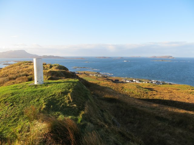
![Torsa from Luing The land in the foreground is the western coast of the isle of Luing at its northern end, looking across to the uninhabited isle of Torsa.
Torsa is almost connected (fordable at low tide) to Luing near Ardinamir Bay.
Although no longer permanently inhabited since the early 1960s, it is possible to stay in a holiday let in the island&#039;s only remaining house - see <span class="nowrap"><a title="https://torsa-island.co.uk" rel="nofollow ugc noopener" href="https://torsa-island.co.uk">Link</a><img style="margin-left:2px;" alt="External link" title="External link - shift click to open in new window" src="https://s1.geograph.org.uk/img/external.png" width="10" height="10"/></span>
The island has never had a large population, but at the beginning of the C19th there were eleven families living here. It has an area of 113ha (280 acres) and its highest point, 62m (203&#039;) is an unnamed hill in the centre of the island.
See also <a href="https://www.geograph.org.uk/photo/7258530">NM7512 : Torsa Beag and Sgeir a' Bhodaich from Luing</a>
[Edit Late 2023] The entire island of Torsa comprising Torsa, Torsa Beag, Eilean na h-Eaglaise, and their reclaimed foreshore is currently up for sale for &quot;offers over £1.5m&quot; - you do get about 270 acres and several buildings for your money though! See <span class="nowrap"><a title="https://island-seeker.com/islands-for-sale/scotland" rel="nofollow ugc noopener" href="https://island-seeker.com/islands-for-sale/scotland">Link</a><img style="margin-left:2px;" alt="External link" title="External link - shift click to open in new window" src="https://s1.geograph.org.uk/img/external.png" width="10" height="10"/></span>](https://s2.geograph.org.uk/geophotos/07/25/83/7258358_d28f3352.jpg)
Rubha Àird a' Choin is a prominent headland located in Argyllshire, Scotland. Situated on the west coast of the country, it juts out into the Atlantic Ocean, offering breathtaking views of the surrounding landscape. The headland is characterized by its rugged cliffs, which reach heights of up to 100 meters, creating a dramatic and awe-inspiring sight.
The name Rubha Àird a' Choin translates to "Point of the Dog's Headland" in English, which is believed to be derived from the shape of the headland resembling a dog's head. The area is rich in natural beauty, with a diverse range of flora and fauna calling it home. Visitors to Rubha Àird a' Choin can expect to see a variety of seabirds, including gannets, puffins, and guillemots, as well as seals basking on the rocks below.
The headland also offers a number of walking trails, allowing visitors to explore the area at their own pace. One popular route takes hikers along the cliff tops, providing panoramic views of the ocean and the nearby islands. Another trail leads down to a secluded beach, which is a great spot for picnicking or simply enjoying the peaceful surroundings.
Rubha Àird a' Choin is not only a picturesque location, but it also holds historical significance. The remains of an ancient fort can be found on the headland, dating back to the Iron Age. This archaeological site offers an insight into the region's early inhabitants and their way of life.
Overall, Rubha Àird a' Choin is a must-visit destination for nature lovers, history enthusiasts, and anyone seeking a serene and captivating coastal experience in Argyllshire, Scotland.
If you have any feedback on the listing, please let us know in the comments section below.
Rubha Àird a' Choin Images
Images are sourced within 2km of 56.247965/-5.6193899 or Grid Reference NM7512. Thanks to Geograph Open Source API. All images are credited.


Rubha Àird a' Choin is located at Grid Ref: NM7512 (Lat: 56.247965, Lng: -5.6193899)
Unitary Authority: Argyll and Bute
Police Authority: Argyll and West Dunbartonshire
What 3 Words
///drags.unusable.tops. Near Lochbuie, Argyll & Bute
Nearby Locations
Related Wikis

Torsa
Torsa (occasionally Torsay) is one of the Slate Islands in Argyll and Bute, Scotland. Lying east of Luing and south of Seil, this tidal island was inhabited...

Slate Islands
The Slate Islands are an island group in the Inner Hebrides, lying immediately off the west coast of Scotland, north of Jura and southwest of Oban. The...

Ardinamir
Ardinamir is an anchorage and small settlement on the island of Luing in Argyll and Bute, Scotland. == References ==

Cuan Sound
Cuan Sound is a narrow channel, 200 metres (660 ft) wide, located in Argyll, western Scotland. It separates Seil and Luing and later becomes the Firth...
Nearby Amenities
Located within 500m of 56.247965,-5.6193899Have you been to Rubha Àird a' Choin?
Leave your review of Rubha Àird a' Choin below (or comments, questions and feedback).