Rubha nan Laogh
Coastal Feature, Headland, Point in Argyllshire
Scotland
Rubha nan Laogh

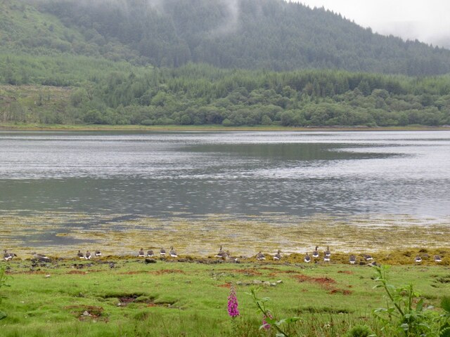
Rubha nan Laogh is a picturesque headland located in Argyllshire, Scotland. Situated on the western coast of the country, this coastal feature offers breathtaking views of the surrounding landscape and the vast expanse of the Atlantic Ocean. The name Rubha nan Laogh translates to "Point of the Calves" in English, reflecting the historical significance of this area.
The headland is characterized by its rugged terrain, with cliffs and rocky outcrops jutting out into the sea. The coastline is dotted with small caves and inlets, providing a habitat for diverse marine life. It is not uncommon to spot seals, dolphins, and various species of seabirds in this area.
Rubha nan Laogh is a popular destination for nature enthusiasts and hikers, who are drawn to its natural beauty and tranquility. There are several walking trails that wind through the headland, allowing visitors to explore the unique flora and fauna of the region. The clear, unpolluted waters surrounding the headland also make it an excellent spot for snorkeling and diving.
Throughout history, Rubha nan Laogh has played a significant role in the lives of the local communities. The headland has witnessed centuries of fishing and maritime activities, contributing to the cultural heritage of the area. Today, it continues to be a place of importance for the local economy, with tourism and outdoor activities playing a vital role.
In conclusion, Rubha nan Laogh is a stunning headland in Argyllshire, Scotland, known for its rugged beauty, diverse wildlife, and historical significance. It is a must-visit destination for anyone seeking to immerse themselves in the natural wonders of the Scottish coastline.
If you have any feedback on the listing, please let us know in the comments section below.
Rubha nan Laogh Images
Images are sourced within 2km of 56.629068/-5.8419357 or Grid Reference NM6455. Thanks to Geograph Open Source API. All images are credited.


Rubha nan Laogh is located at Grid Ref: NM6455 (Lat: 56.629068, Lng: -5.8419357)
Unitary Authority: Highland
Police Authority: Highlands and Islands
What 3 Words
///riots.cobras.including. Near Drimnin, Highland
Nearby Locations
Related Wikis

Barr River, Morvern
Barr River is a short watercourse in Morvern in the Scottish Highlands. Its principal tributaries are the Allt Ghleann Sleibhtecoire and the Allt na Lice...
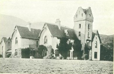
Glencripesdale House
Glencripesdale House, or Glencripesdale Castle as it was sometimes referred to, was the centre of the 26,000-acre (11,000-hectare) Glencripesdale Estate...
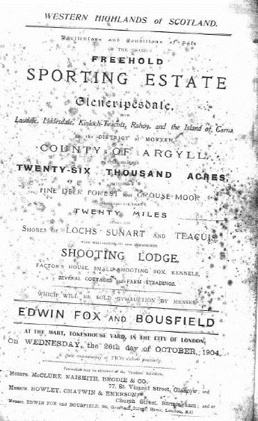
Glencripesdale Estate
The Glencripesdale Estate is a country estate situated along the south side of Loch Sunart, a sea loch in the west highlands of Scotland. Today, the Isle...

Càrna
Carna or Càrna is an island in Loch Sunart, an arm of the sea, close to the Ardnamurchan peninsula, on the west coast of Scotland. == Geography == Carna...
Nearby Amenities
Located within 500m of 56.629068,-5.8419357Have you been to Rubha nan Laogh?
Leave your review of Rubha nan Laogh below (or comments, questions and feedback).