Àird Tharsgabhaig

Coastal Feature, Headland, Point in Inverness-shire

Scotland

Àird Tharsgabhaig

House at Tarscabhaig A house with a beautiful situation and a fine view to the south.
House at Tarscabhaig Credit: Anne Burgess

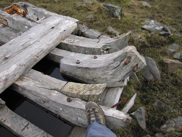
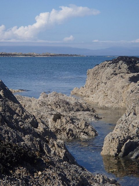
Àird Tharsgabhaig is a rocky headland located in Inverness-shire, Scotland. Situated along the coast, this point offers stunning views of the surrounding landscape and the sea. The rugged terrain of the headland is characterized by tall cliffs, rocky outcrops, and grassy slopes.

The area is known for its rich biodiversity, with a variety of plant and animal species inhabiting the rocky shores and grassy fields. Visitors to Àird Tharsgabhaig can expect to see seabirds such as gulls and puffins nesting on the cliffs, as well as seals and other marine life in the waters below.

The headland is a popular destination for hikers and nature enthusiasts, with several walking trails and paths leading to various viewpoints and lookout spots. The coastal location also provides opportunities for fishing, birdwatching, and other outdoor activities.

Overall, Àird Tharsgabhaig is a picturesque and peaceful spot where visitors can enjoy the beauty of Scotland's coastal landscape and immerse themselves in nature.

If you have any feedback on the listing, please let us know in the comments section below.

Àird Tharsgabhaig Images

Images are sourced within 2km of 57.114526/-6.0022471 or Grid Reference NG5709. Thanks to Geograph Open Source API. All images are credited.

House at Tarscabhaig A house with a beautiful situation and a fine view to the south.
House at Tarscabhaig
A house with a beautiful situation and a fine view to the south.
Bàgh Tharsgabhaig The southern beach in Tarskavaig Bay (near Achnacloich) at low water.
The Cuillin is covered by cloud, but Blabheinn is attempting to make an appearance (centre). Belig is clear to the right.
Bàgh Tharsgabhaig
The southern beach in Tarskavaig Bay (near Achnacloich) at low water. The Cuillin is covered by cloud, but Blabheinn is attempting to make an appearance (centre). Belig is clear to the right.
Tarscavaig - 1980 Tarscavaig, Isle of Skye.
Tarskavaig is a crofting village on the West coast of Sleat on the Isle of Skye in Scotland. It sits in a glen which meets Tarskavaig Bay and lies opposite the Isles of Eigg, Rum and Canna. 
It is often said that Tarskavaig has the best view of the Cuillin in Skye.
Tarscavaig - 1980
Tarscavaig, Isle of Skye. Tarskavaig is a crofting village on the West coast of Sleat on the Isle of Skye in Scotland. It sits in a glen which meets Tarskavaig Bay and lies opposite the Isles of Eigg, Rum and Canna. It is often said that Tarskavaig has the best view of the Cuillin in Skye.
Beach at Gillean A view south over autumn-coloured moorland from the unclassified road to Tarskavaig.
Beach at Gillean
A view south over autumn-coloured moorland from the unclassified road to Tarskavaig.
Tarskavaig Bay An autumn view to compare to John Allan's springtime photograph taken from the same spot. 
(<a href="https://www.geograph.org.uk/photo/816610">NG5809 : Tarskavaig Bay</a>).
Tarskavaig Bay
An autumn view to compare to John Allan's springtime photograph taken from the same spot. (NG5809 : Tarskavaig Bay).
Tarskavaig Bay Tarskavaig Bay, Isle of Skye, July 2001 with Tarskavaig Point in the foreground. In the distance can be seen the Cuillin Hills.
Tarskavaig Bay
Tarskavaig Bay, Isle of Skye, July 2001 with Tarskavaig Point in the foreground. In the distance can be seen the Cuillin Hills.
Disused church at Tarskavaig Notice how the roof of the side building has collapsed compared to this photo in 2006 <a title="https://www.geograph.org.uk/photo/173960" href="https://www.geograph.org.uk/photo/173960">Link</a>
Disused church at Tarskavaig
Notice how the roof of the side building has collapsed compared to this photo in 2006 Link
Old boat hull It's hard to visualise what size this boat must have been, but my boot (for scale) indicates that it was not a small rowing boat.
Old boat hull
It's hard to visualise what size this boat must have been, but my boot (for scale) indicates that it was not a small rowing boat.
Tarskavaig Free Church Tarskavaig Free church and school, built circa 1860, and believed to have been abandoned circa 1960.
Tarskavaig Free Church
Tarskavaig Free church and school, built circa 1860, and believed to have been abandoned circa 1960.
Tarskavaig Free Church - Pier Pier was built circa 1846/7 to provide assistance during a period of extreme hardship (Potato Blight).  The crofters were apparently given a bowl of meal for a day's work on the pier.
Tarskavaig Free Church - Pier
Pier was built circa 1846/7 to provide assistance during a period of extreme hardship (Potato Blight). The crofters were apparently given a bowl of meal for a day's work on the pier.
Tarskavaig church and schoolhouse Located beyond the end of the current road, the 19th century church is disused.
Tarskavaig church and schoolhouse
Located beyond the end of the current road, the 19th century church is disused.
Inside Tarskavaig church Abandoned, but still with its pews and pulpit.
Inside Tarskavaig church
Abandoned, but still with its pews and pulpit.
Tarskavaig Bay View near Gillean, a grand combination of coast and mountain in view.
Tarskavaig Bay
View near Gillean, a grand combination of coast and mountain in view.
Lane to Tarskavaig View near Gillean just after the lane reaches the coastline and heads north passing a succession of bays and headlands.
Lane to Tarskavaig
View near Gillean just after the lane reaches the coastline and heads north passing a succession of bays and headlands.
Gillean Burn running into Tarskavaig Bay A lovely shoreline accessible from the lane.
Gillean Burn running into Tarskavaig Bay
A lovely shoreline accessible from the lane.
Rocky coastline, Tarskavaig Bay An area of pale rocks and pools at the edge of the beach at Tarskavaig Bay.
Rocky coastline, Tarskavaig Bay
An area of pale rocks and pools at the edge of the beach at Tarskavaig Bay.
Headland near Tarskavaig with view to Rum The lane winds up and down between bays and headlands with scattered communities and fine views of the coast and isles.
Headland near Tarskavaig with view to Rum
The lane winds up and down between bays and headlands with scattered communities and fine views of the coast and isles.
View of Tarskavaig village The view from the top lane passing above the village.
View of Tarskavaig village
The view from the top lane passing above the village.
Show me another place!

Àird Tharsgabhaig is located at Grid Ref: NG5709 (Lat: 57.114526, Lng: -6.0022471)

Unitary Authority: Highland

Police Authority: Highlands and Islands

What 3 Words

///pans.circles.birdcage. Near Elgol, Highland

Nearby Locations

Àird Tharsgabhaig

Related Wikis

Tarskavaig

Tarskavaig (Tarsgabhaig in Scottish Gaelic) is a crofting village on the west coast of Sleat on the Isle of Skye in Scotland. It sits in a glen which meets...
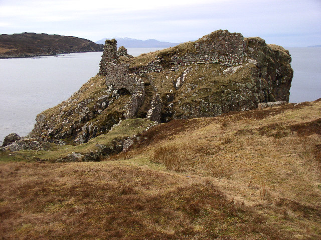
Dunscaith Castle

Dunscaith Castle also known as Dun Scaich, Dun Sgathaich Castle and Tokavaig, is a ruined castle on the coast of the Isle of Skye, in the north-west of...

Sleat

Sleat is a peninsula and civil parish on the island of Skye in the Highland council area of Scotland, known as "the garden of Skye". It is the home of...

Strathaird

Strathaird is a peninsula on the island of Skye, Scotland, situated between Loch Slapin and Loch Scavaig on the south coast.W. H. Murray said that "Skye...

Nearby Amenities

Located within 500m of 57.114526,-6.0022471
Àird Tharsgabhaig
Natural: cape
Lat/Long: 57.1133506/-6.0029756
Camas Daraich
Natural: bay
Lat/Long: 57.1166127/-6.0042201
The data included in this document is from www.openstreetmap.org. The data is made available under ODbL.

Have you been to Àird Tharsgabhaig?

Leave your review of Àird Tharsgabhaig below (or comments, questions and feedback).