Àird Chill Fhinichin

Coastal Feature, Headland, Point in Argyllshire

Scotland

Àird Chill Fhinichin

Kilfinichen Church, Isle of Mull
Kilfinichen Church, Isle of Mull Credit: J M Briscoe

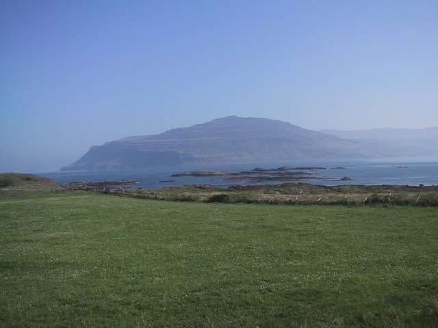
Àird Chill Fhinichin, also known as the Point of Kilmun, is a prominent coastal feature located in Argyllshire, Scotland. This headland juts out into the waters of the Holy Loch, offering spectacular views and a rich history to its visitors.

Situated on the Cowal Peninsula, Àird Chill Fhinichin is characterized by its rugged cliffs, which rise dramatically from the sea. The headland is covered in lush greenery, with a variety of trees and shrubs dotting the landscape. This natural beauty is enhanced by the presence of an ancient graveyard, adding an air of mystery and historical significance to the site.

The area has been inhabited for centuries, with evidence of human activity dating back to prehistoric times. The ruins of a medieval church can still be seen on the headland, providing a glimpse into the area's past. The site is also associated with the Clan Campbell, one of Scotland's most powerful clans, who once owned the nearby Dunoon Castle.

Visitors to Àird Chill Fhinichin can enjoy stunning panoramic views of the Holy Loch and the surrounding mountains. The headland is a popular spot for hiking and nature walks, with several trails leading through the rugged terrain. Birdwatchers will also delight in the diverse range of species that can be spotted in the area.

Overall, Àird Chill Fhinichin is a captivating coastal feature that offers both natural beauty and a rich historical tapestry. Its dramatic cliffs, ancient ruins, and stunning views make it a must-visit destination for nature enthusiasts and history buffs alike.

If you have any feedback on the listing, please let us know in the comments section below.

Àird Chill Fhinichin Images

Images are sourced within 2km of 56.377978/-6.0598043 or Grid Reference NM4928. Thanks to Geograph Open Source API. All images are credited.

Kilfinichen Church, Isle of Mull
Abhainn Bail A'Mhuilinn
Loch Scridain
Loch Scridain
Thrift, Traigh Mhor There are few machairs on Mull, Calagary Bay has one. This could be said to be a small one.
Thrift, Traigh Mhor
There are few machairs on Mull, Calagary Bay has one. This could be said to be a small one.
Woodland, Tiroran House
Buildings at Balevulin The BT telephone exchange is the one on the left.
Buildings at Balevulin
The BT telephone exchange is the one on the left.
Kilfinichan Bay With Sunnybank Villa and Loch Scridain
Kilfinichan Bay
With Sunnybank Villa and Loch Scridain
Forestry This section of trees, with the Ardmeanach headland behind it, is the residence of a pair of White Tailed (sea) Eagles.
Forestry
This section of trees, with the Ardmeanach headland behind it, is the residence of a pair of White Tailed (sea) Eagles.
Plant Euphorbia A wonderful bright orange patch to enliven the green sides of the road.
Plant Euphorbia
A wonderful bright orange patch to enliven the green sides of the road.
The Steadings, Tiroran
Drystone wall and forest clearing This wall is evidently from an old estate wall that may have served as a retaining wall for the forest element at image right. This is a conifer plantation that has not been disturbed for some considerable length of time. A small water rivulet is running down the clearing to join the main burn about 200 metres downhill from here. Old rusted parts of an iron gate were found loose on the ground here.
Drystone wall and forest clearing
This wall is evidently from an old estate wall that may have served as a retaining wall for the forest element at image right. This is a conifer plantation that has not been disturbed for some considerable length of time. A small water rivulet is running down the clearing to join the main burn about 200 metres downhill from here. Old rusted parts of an iron gate were found loose on the ground here.
Bracken lined road with pasture and farm below
Mudflats at Bagh Chill Fhinichin Photographer is positioned not far south of the minor road.
Mudflats at Bagh Chill Fhinichin
Photographer is positioned not far south of the minor road.
Backshore near Aird Chill Fhinichin Photographer is located at a point not far from the church.
Backshore near Aird Chill Fhinichin
Photographer is located at a point not far from the church.
Grounds and path at Tiroran
Looking downhill from the Tiroran access drive Photographer is standing not far south of the southern edge of an access drive to Tiroran House.
Looking downhill from the Tiroran access drive
Photographer is standing not far south of the southern edge of an access drive to Tiroran House.
Seabank Villa across Kilfinichen Bay
Show me another place!

Àird Chill Fhinichin is located at Grid Ref: NM4928 (Lat: 56.377978, Lng: -6.0598043)

Unitary Authority: Argyll and Bute

Police Authority: Argyll and West Dunbartonshire

What 3 Words

///smoke.forget.salary. Near Lochbuie, Argyll & Bute

Related Wikis

Tiroran

Tiroran is hamlet on the Isle of Mull in Argyll and Bute, Scotland. == History == In the late 18th century Tiroran House was associated with the McKinnon...

Loch Scridain

Loch Scridain is a 15-kilometre-long (9-mile) sea loch, with a west-south west aspect, on the western, or Atlantic coastline of the Isle of Mull, in the...

Pennyghael

Pennyghael (Scottish Gaelic: Peighinn nan Gàidheal) is a small village in the Ross of Mull, Argyll and Bute, Scotland. It is located along the A849 road...

Aird of Kinloch

Aird of Kinloch (Gaelic:An Àird) is a rocky outcrop between Loch Scridain and Loch Beg on the Isle of Mull, Argyll and Bute, Scotland. == References ==

Ardmeanach

Ardmeanach in modern times refers to a peninsula on the Isle of Mull. It is the middle one out of three westward-facing peninsulas on the island, and the...

Ben More (Mull)

Ben More (Scottish Gaelic: Beinn Mhòr, meaning "great mountain") is the highest mountain and only Munro (mountains in Scotland that reach an elevation...

Carsaig Bay

Carsaig Bay is a cove on the Ross of Mull in the south of the Isle of Mull, off the west coast of Scotland. It is situated 5 kilometres (3 miles) eastward...

Isle of Mull

The Isle of Mull (Scottish Gaelic: An t-Eilean Muileach [əɲ ˈtʲʰelan ˈmuləx]) or just Mull (Scots pronunciation: [mʌl]; Scottish Gaelic: Muile [ˈmulə]...

Nearby Amenities

Located within 500m of 56.377978,-6.0598043
Source: PGS
Lat/Long: 56.3806393/-6.0540361
Source: PGS
Lat/Long: 56.3782568/-6.0628155
Source: PGS
Lat/Long: 56.3787809/-6.0626636
Source: PGS
Lat/Long: 56.3789912/-6.0621818
Source: PGS
Lat/Long: 56.3795736/-6.0608882
Source: PGS
Lat/Long: 56.3797427/-6.0610288
Source: PGS
Lat/Long: 56.3800334/-6.060661
Source: PGS
Lat/Long: 56.3802066/-6.0600651
Source: PGS
Lat/Long: 56.3806706/-6.0599525
Source: PGS
Lat/Long: 56.3813012/-6.060633
Source: PGS
Lat/Long: 56.381725/-6.0615373
Source: PGS
Lat/Long: 56.3819689/-6.0624053
Telephone
Booth: K6
Covered: booth
Lat/Long: 56.3815889/-6.0577775
Post Box
Post Box Type: lamp
Ref: PA69 149
Royal Cypher: scottish_crown
Lat/Long: 56.3815887/-6.0578243
Power: pole
Lat/Long: 56.3823472/-6.0598131
Power: pole
Lat/Long: 56.3821476/-6.059166
Power: pole
Lat/Long: 56.3819525/-6.058523
Power: pole
Lat/Long: 56.3815931/-6.0551741
The data included in this document is from www.openstreetmap.org. The data is made available under ODbL.

Have you been to Àird Chill Fhinichin?

Leave your review of Àird Chill Fhinichin below (or comments, questions and feedback).