Am Maol

Coastal Feature, Headland, Point in Argyllshire

Scotland

Am Maol

Approaching the pier at Muck
Approaching the pier at Muck Credit: Alan Reid

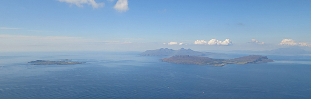
Am Maol is a prominent coastal feature located in Argyllshire, Scotland. Positioned on the western coast, it is a headland that extends into the Atlantic Ocean, forming a distinctive point. The name "Am Maol" translates to "the bald" in Scottish Gaelic, referring to the bare and rugged nature of the landscape.

This headland is characterized by its dramatic cliffs, which tower over the surrounding sea. The cliffs are made up of layers of sedimentary rock, primarily composed of sandstone and shale, providing a glimpse into the geological history of the area. The exposed rock formations showcase the effects of weathering and erosion, displaying intricate patterns and textures.

Am Maol is situated within a region known for its diverse and abundant marine life. The coastal waters surrounding the headland are home to various species of fish, including cod, haddock, and mackerel. Seabirds and marine mammals, such as seals and dolphins, can also be observed in the vicinity.

Visitors to Am Maol can enjoy breathtaking panoramic views of the ocean and the surrounding coastal landscape. The headland offers a perfect vantage point for witnessing stunning sunsets over the water. Additionally, the area is a popular spot for outdoor activities, including hiking and birdwatching.

Overall, Am Maol in Argyllshire is a captivating coastal feature that showcases the natural beauty and rugged charm of Scotland's western coastline.

If you have any feedback on the listing, please let us know in the comments section below.

Am Maol Images

Images are sourced within 2km of 56.844474/-6.2230403 or Grid Reference NM4280. Thanks to Geograph Open Source API. All images are credited.

Approaching the pier at Muck
The old pier, Port Mòr
The Coastguard team leaving Muck after an exercise with local auxiliaries
Isle of Muck Photographed from a Glasgow to Benbecula flight.
Isle of Muck
Photographed from a Glasgow to Benbecula flight.
Muck, Rum and Eigg Three of the Small Isles from the air. Muck is on the left, Eigg on the right and Rum, with its high peaks, is in the background. The Black Cuillins of Skye are at extreme right.
Muck, Rum and Eigg
Three of the Small Isles from the air. Muck is on the left, Eigg on the right and Rum, with its high peaks, is in the background. The Black Cuillins of Skye are at extreme right.
Muck seen from Eigg The Isle of Muck seen from the summit of An Sgurr. In front is Dubh Sgeir, the tiny island of Godag is right of centre with Eilean nan Each to the right of Muck.
Muck seen from Eigg
The Isle of Muck seen from the summit of An Sgurr. In front is Dubh Sgeir, the tiny island of Godag is right of centre with Eilean nan Each to the right of Muck.
Harbour at Port Mor, Isle of Muck Taken from Cal/Mac ferry Loch Nevis
Harbour at Port Mor, Isle of Muck
Taken from Cal/Mac ferry Loch Nevis
Eastern shore of Muck A small section of the coast of Muck sits in this square.   This appears towards the centre of this picture.
Eastern shore of Muck
A small section of the coast of Muck sits in this square. This appears towards the centre of this picture.
Chickens by the road to Port Mòr
Memorial and ruined chapel, A' Chill, Isle of Muck
Old wall, Isle of Muck
Caisteil an Duin Bhain, Isle of Muck
Port Mòr, Isle of Muck Port Mòr is both the name of the inlet and the small village beside it. This is the limit of the Port Mòr inlet. The backbone of Eigg makes a fitting backcloth.
Port Mòr, Isle of Muck
Port Mòr is both the name of the inlet and the small village beside it. This is the limit of the Port Mòr inlet. The backbone of Eigg makes a fitting backcloth.
The head of Port Mòr, Isle of Muck Far beyond, the mountains of the Isle of Rum peep over the Muck skyline.
The head of Port Mòr, Isle of Muck
Far beyond, the mountains of the Isle of Rum peep over the Muck skyline.
MV Lochnevis at Port Mòr, Isle of Muck MV Lochnevis has served The Small Isles since November 2001.
MV Lochnevis at Port Mòr, Isle of Muck
MV Lochnevis has served The Small Isles since November 2001.
MV Lochnevis discharging at Muck The vessel calls five days a week in summer.
MV Lochnevis discharging at Muck
The vessel calls five days a week in summer.
Promontory by Port Mòr, Isle of Muck A quiet place to stare at the beauty of the Western seaboard of Scotland.  The mountains of Mull are prominent in this view.
Promontory by Port Mòr, Isle of Muck
A quiet place to stare at the beauty of the Western seaboard of Scotland. The mountains of Mull are prominent in this view.
Muck from a highpoint on Rum The peaks of Rum give an exhilarating view both south and west.  To the west the Outer Hebrides command attention, whilst due southwards the small island of Muck looks intriguing, and encourages one to consider a visit later in life when mountaineering may become too energetic a way to spend a holiday.
Muck from a highpoint on Rum
The peaks of Rum give an exhilarating view both south and west. To the west the Outer Hebrides command attention, whilst due southwards the small island of Muck looks intriguing, and encourages one to consider a visit later in life when mountaineering may become too energetic a way to spend a holiday.
Show me another place!

Am Maol is located at Grid Ref: NM4280 (Lat: 56.844474, Lng: -6.2230403)

Unitary Authority: Highland

Police Authority: Highlands and Islands

What 3 Words

///lies.crackled.shiver. Near Kilchoan, Highland

Related Wikis

Port Mòr

Port Mòr is a harbour and settlement on the Isle of Muck in the Inner Hebrides off the west coast of Scotland.Port Mòr is the most populated settlement...

Muck, Scotland

Muck (; Scottish Gaelic: Eilean nam Muc) is the smallest of four main islands in the Small Isles, part of the Inner Hebrides of Scotland. Today, much of...

An Sgùrr (Eigg)

An Sgùrr is the highest hill on the Inner Hebridean island of Eigg, Lochaber, Highland, Scotland. It was formed 58.72 ± 0.07 million years ago; the result...

Galmisdale

Galmisdale is the main port of the island of Eigg, one of the Small Isles of the Inner Hebrides. It is in the Scottish council area of Highland. ��2�...

Eilean Chathastail

Eilean Chathastail (Eng: Castle Island) is one of the Small Isles in the Inner Hebrides of Scotland. == Geography == Eilean Chathastail...

Eigg

Eigg ( eg; Scottish Gaelic: Eige; Scots: Eigg) is one of the Small Isles in the Scottish Inner Hebrides. It lies to the south of the Isle of Skye and to...

Cleadale

Cleadale (Scottish Gaelic: Clèadail) is a settlement on the north west side of the island of Eigg, in the Small Isles of Scotland and is in the council...

Nearby Amenities

Located within 500m of 56.844474,-6.2230403
Port nam Maol
Lang: gd
Natural: bay
Lat/Long: 56.8457098/-6.2261689
Innacamas
Lang: gd
Natural: bay
Lat/Long: 56.8461616/-6.228658
Blàr Mòr
Place: isolated_dwelling
Lat/Long: 56.8425595/-6.2302351
The data included in this document is from www.openstreetmap.org. The data is made available under ODbL.

Have you been to Am Maol?

Leave your review of Am Maol below (or comments, questions and feedback).