Àird Mhòr

Coastal Feature, Headland, Point in Inverness-shire

Scotland

Àird Mhòr

A bracken-filled field, interrupted by a quirky post and wire fence. Beyond, behold the enchanting Àird Mhor, dancing with Ardmore Bay's captivating allure.
A bracken-filled field, interrupted by a quirky post and wire fence. Credit: Mick Garratt

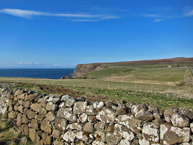
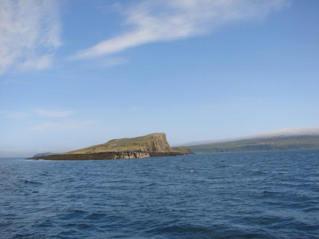
Àird Mhòr, located in Inverness-shire, Scotland, is a prominent coastal feature that encompasses a headland and point. Situated on the west coast of Scotland, it lies within the picturesque area known as the Scottish Highlands. This coastal feature is renowned for its stunning natural beauty and rugged landscape.

Àird Mhòr is characterized by its dramatic cliffs that tower above the crashing waves of the Atlantic Ocean. These cliffs offer breathtaking panoramic views of the surrounding area, including the vast expanse of the ocean and the distant mountains. The headland juts out into the sea, forming a distinctive point that is a popular destination for nature enthusiasts and photographers.

The coastline around Àird Mhòr is dotted with a variety of fascinating rock formations, caves, and arches, which have been sculpted over thousands of years by the relentless power of the sea. These geological features provide a unique habitat for a diverse range of marine life, making it a haven for wildlife enthusiasts and birdwatchers. Visitors to Àird Mhòr may spot seals, dolphins, and various species of seabirds, including puffins and gannets.

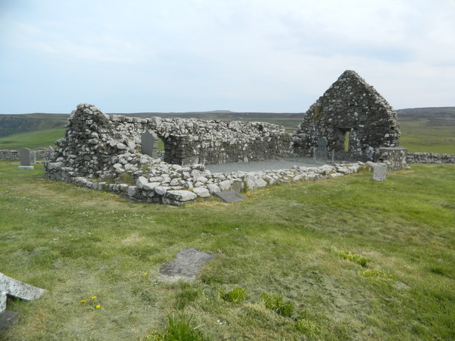
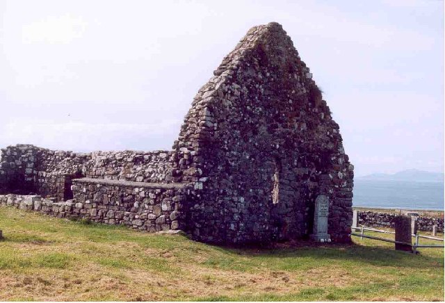
Aside from its natural beauty, Àird Mhòr also holds historical significance. The area is home to the ruins of an ancient fort, which once served as a strategic defensive position. This fort, with its commanding views of the coastline, offers a glimpse into the region's rich history and serves as a reminder of the area's past.

In conclusion, Àird Mhòr in Inverness-shire is a captivating coastal feature that encompasses a headland and point. With its dramatic cliffs, stunning views, and rich biodiversity, it is a must-visit destination for those seeking to explore the natural wonders of the Scottish Highlands.

If you have any feedback on the listing, please let us know in the comments section below.

Àird Mhòr Images

Images are sourced within 2km of 57.546095/-6.6513623 or Grid Reference NG2160. Thanks to Geograph Open Source API. All images are credited.

A bracken-filled field, interrupted by a quirky post and wire fence. Beyond, behold the enchanting Àird Mhor, dancing with Ardmore Bay's captivating allure.
A bracken-filled field, interrupted by a quirky post and wire fence.
Beyond, behold the enchanting Àird Mhor, dancing with Ardmore Bay's captivating allure.
In a world of their own, guided by sunshine and Cow parsley
Cottage at Ardmore The tiny cottage was restored from a roofless ruin more than 40 years ago. Sections of wall and other ruins, probably a farmstead and kiln barn, still surround it, and parts of the cobbled courtyard pre-date the restoration of the garden. 
Locational view: <a href="https://www.geograph.org.uk/photo/4906412">NG2261 : North from Trumpan</a>.
Cottage at Ardmore
The tiny cottage was restored from a roofless ruin more than 40 years ago. Sections of wall and other ruins, probably a farmstead and kiln barn, still surround it, and parts of the cobbled courtyard pre-date the restoration of the garden. Locational view: NG2261 : North from Trumpan.
North from Trumpan Grazing land on the Waternish peninsula. The cottage on the right was once part of a larger farmstead. 
See also: <a href="https://www.geograph.org.uk/photo/4906406">NG2261 : Cottage at Ardmore</a>.
North from Trumpan
Grazing land on the Waternish peninsula. The cottage on the right was once part of a larger farmstead. See also: NG2261 : Cottage at Ardmore.
Trumpan cemetery The modern cemetery is an extension of the ancient burial ground which surrounds the ruin of Trumpan church.
Trumpan cemetery
The modern cemetery is an extension of the ancient burial ground which surrounds the ruin of Trumpan church.
Resting in Peace Even in a place as beautiful as Skye, there can be no other cemetery with such a peaceful location and fine view.
This is Trumpan cemetery, Waternish. The recent interment is of a popular local resident who lived nearby for very many years.
Resting in Peace
Even in a place as beautiful as Skye, there can be no other cemetery with such a peaceful location and fine view. This is Trumpan cemetery, Waternish. The recent interment is of a popular local resident who lived nearby for very many years.
Over a gate in Waternish Sheep and cattle are sharing the rough pasture.
Over a gate in Waternish
Sheep and cattle are sharing the rough pasture.
Road in Trumpan Looking south. The road is part of a loop which serves the few houses at the tip of the Waternish peninsula.
Road in Trumpan
Looking south. The road is part of a loop which serves the few houses at the tip of the Waternish peninsula.
Ruins of Trumpan church, Isle of Skye
Roadside dwellings above Ardmore bay, Isle of Skye
Ardmore Bay, Waternish In the distance is Dunvegan Head.
Ardmore Bay, Waternish
In the distance is Dunvegan Head.
Rogheadh
Rogheadh
Ard Beag
Ard Beag
Rogheadh - natural arches
Trumpan burial ground Taken from the part of the burial ground that is currently used for interments.
Trumpan burial ground
Taken from the part of the burial ground that is currently used for interments.
Clach Deuchainn Clach Deuchainn (the trial stone) stands in the grounds of Trumpan Church. It is a prehistoric standing stone, also known as the Priest's Stone.
The cracks are jammed full of coins, I know not why. The story that goes with the stone is that if an accused person is able to insert their index finger into the hole near the top while blindfolded, they are innocent of the offence.
Clach Deuchainn
Clach Deuchainn (the trial stone) stands in the grounds of Trumpan Church. It is a prehistoric standing stone, also known as the Priest's Stone. The cracks are jammed full of coins, I know not why. The story that goes with the stone is that if an accused person is able to insert their index finger into the hole near the top while blindfolded, they are innocent of the offence.
Memorial stone to Rachel Chiesley, Lady Grange This memorial stone in Trumpan Churchyard reads:

RIP
Rachel
wife of
The Hon James Erskine
Lord Grange
Died AD 1746

The story of Lady Grange is long, complex and quite remarkable, see <span class="nowrap"><a title="http://en.wikipedia.org/wiki/Rachel_Chiesley,_Lady_Grange" rel="nofollow ugc noopener" href="http://en.wikipedia.org/wiki/Rachel_Chiesley,_Lady_Grange">Link</a><img style="margin-left:2px;" alt="External link" title="External link - shift click to open in new window" src="https://s1.geograph.org.uk/img/external.png" width="10" height="10"/></span>
Memorial stone to Rachel Chiesley, Lady Grange
This memorial stone in Trumpan Churchyard reads: RIP Rachel wife of The Hon James Erskine Lord Grange Died AD 1746 The story of Lady Grange is long, complex and quite remarkable, see LinkExternal link
Yellow and Blue Study Across the road from Trumpan Church the yellow wild flowers contrast with the blue of The Little Minch.
Yellow and Blue Study
Across the road from Trumpan Church the yellow wild flowers contrast with the blue of The Little Minch.
Show me another place!

Àird Mhòr is located at Grid Ref: NG2160 (Lat: 57.546095, Lng: -6.6513623)

Unitary Authority: Highland

Police Authority: Highlands and Islands

What 3 Words

///deflection.vies.should. Near Glendale, Highland

Nearby Locations

Rogheadh Àird Mhòr

Related Wikis

Trumpan

Trumpan (Scottish Gaelic: Trumpan) is a hamlet located on the Vaternish peninsula in the Isle of Skye, in the Scottish council area of the Highland. Trumpan...
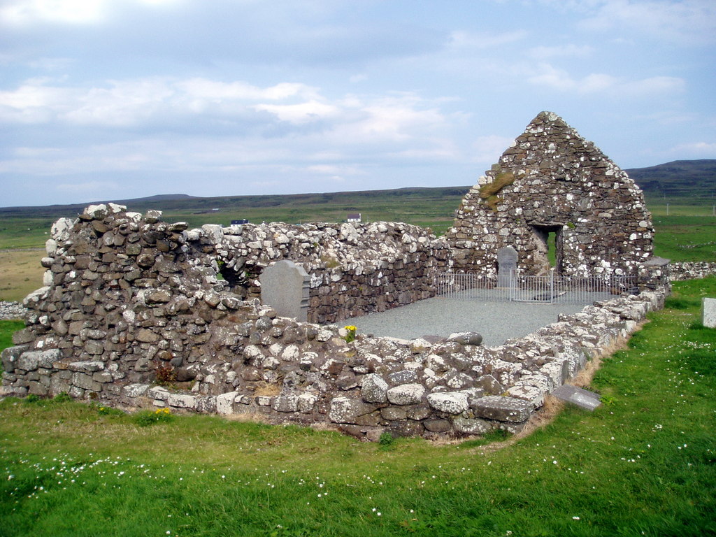
Trumpan Church

Trumpan Church is a ruined medieval church located on the Isle of Skye in Scotland. In 1578, the church was the site of a brutal massacre of the Clan MacLeod...

Mingay

Mingay is an islet in the Inner Hebrides off Skye and Isay. Together with Isay and Loch Dunvegan, it is designated as a Special Area of Conservation owing...

Halistra

Halistra (Scottish Gaelic: Halastra), is a small crofting township located on the west coast of the Waternish peninsula, overlooking Loch Bay, on the island...

Nearby Amenities

Located within 500m of 57.546095,-6.6513623
Source: PGS
Lat/Long: 57.5500353/-6.6531861
Source: PGS
Lat/Long: 57.5486099/-6.6539395
Source: PGS
Lat/Long: 57.5478627/-6.6541762
Source: PGS
Lat/Long: 57.5469798/-6.6547613
Source: PGS
Lat/Long: 57.546089/-6.6552238
Source: PGS
Lat/Long: 57.5458431/-6.6546284
Source: PGS
Lat/Long: 57.5456309/-6.6548043
Source: PGS
Lat/Long: 57.5454425/-6.6546211
Source: PGS
Lat/Long: 57.5446472/-6.6542826
Source: PGS
Lat/Long: 57.5444629/-6.6540723
Source: PGS
Lat/Long: 57.5443489/-6.6537054
Source: PGS
Lat/Long: 57.5441232/-6.6538191
Source: PGS
Lat/Long: 57.5441019/-6.6533288
Source: PGS
Lat/Long: 57.543472/-6.652345
Source: PGS
Lat/Long: 57.5430408/-6.6525134
Source: PGS
Lat/Long: 57.5428646/-6.6517399
Source: PGS
Lat/Long: 57.542936/-6.6499353
Source: PGS
Lat/Long: 57.5431945/-6.6499246
Source: PGS
Lat/Long: 57.543502/-6.6495984
Source: PGS
Lat/Long: 57.5443708/-6.6490491
Source: PGS
Lat/Long: 57.5453237/-6.6484708
Source: PGS
Lat/Long: 57.5456179/-6.6480084
Source: PGS
Lat/Long: 57.546136/-6.6472155
Created By: dmgroom_coastlines
Source: PGS
Lat/Long: 57.5464/-6.64722
Source: PGS
Lat/Long: 57.5467008/-6.6470524
Source: PGS
Lat/Long: 57.5469357/-6.6479065
Source: PGS
Lat/Long: 57.54712/-6.6481189
Source: PGS
Lat/Long: 57.5470358/-6.6485196
Source: PGS
Lat/Long: 57.5471286/-6.6489993
Source: PGS
Lat/Long: 57.5472944/-6.6495191
Source: PGS
Lat/Long: 57.548117/-6.650036
Source: PGS
Lat/Long: 57.548462/-6.650262
Source: PGS
Lat/Long: 57.5488355/-6.6512061
Source: PGS
Lat/Long: 57.5495598/-6.6515561
Source: PGS
Lat/Long: 57.5501769/-6.6513947
Àrd Mòr
Alt Name: Ardmore Point
Natural: cape
Wikidata: Q24657009
Lat/Long: 57.5451993/-6.6509813
Blar Mhilleadh-garaidh
Historic: battlefield
Note: site of conflict between the Macleads and Macdonalds
Source: OS Scottish Popular Historic
Lat/Long: 57.549908/-6.6521808
Rogheadh
Place: locality
Lat/Long: 57.5461466/-6.6553809
Ele: 33
Natural: peak
Lat/Long: 57.5463742/-6.6546096
The data included in this document is from www.openstreetmap.org. The data is made available under ODbL.

Have you been to Àird Mhòr?

Leave your review of Àird Mhòr below (or comments, questions and feedback).