Àird Caol

Coastal Feature, Headland, Point in Inverness-shire

Scotland

Àird Caol

Ruin at Ardvey Abandoned and derelict, in spite of being relatively modern.
Ruin at Ardvey Credit: Richard Dorrell

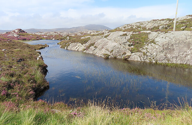
Àird Caol is a prominent coastal feature located in Inverness-shire, Scotland. It is a headland that juts out into the waters of the North Atlantic Ocean, forming a distinct point along the rugged coastline. The name "Àird Caol" translates to "narrow headland" in Gaelic, which accurately describes its physical characteristics.

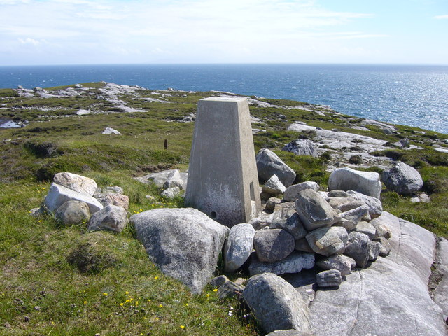
The headland is characterized by steep cliffs that rise dramatically from the sea, offering breathtaking views of the surrounding landscape. These cliffs are composed of various types of rock, including sandstone and granite, which have been shaped by the forces of erosion over time. The headland also features a rocky shoreline, with small coves and inlets that provide sheltered areas for marine life.

Àird Caol is known for its rich biodiversity, with a diverse range of flora and fauna inhabiting the area. The headland is home to a variety of seabirds, including gulls, puffins, and cormorants, which nest along the cliffs. It is also a popular spot for birdwatching enthusiasts who flock to the area to observe these magnificent creatures in their natural habitat.

In addition to its natural beauty, Àird Caol is also steeped in history and folklore. The headland has been a site of human activity for centuries, with evidence of ancient settlements and burial sites in the surrounding area. Local folklore tells tales of mythical creatures and legends associated with the headland, adding to its mystique and allure.

Overall, Àird Caol is a captivating coastal feature that combines stunning natural beauty, rich biodiversity, and historical significance. It is a must-visit destination for nature lovers, history enthusiasts, and those seeking an escape into the wild and rugged beauty of the Scottish coastline.

If you have any feedback on the listing, please let us know in the comments section below.

Àird Caol Images

Images are sourced within 2km of 57.774243/-6.8949697 or Grid Reference NG0986. Thanks to Geograph Open Source API. All images are credited.

Ruin at Ardvey Abandoned and derelict, in spite of being relatively modern.
Ruin at Ardvey
Abandoned and derelict, in spite of being relatively modern.
Loch Fhionnsabhaigh The blue pay-to-view telescope is probably there to enable seal-watchers to get a closer view - though as the seals were today basking on rocks just a few yards from the shore, the scope was barely necessary.
See also: <a href="https://www.geograph.org.uk/photo/7033022">NG0887 : Common seals in Loch Fhionnsabhaigh</a>.
Loch Fhionnsabhaigh
The blue pay-to-view telescope is probably there to enable seal-watchers to get a closer view - though as the seals were today basking on rocks just a few yards from the shore, the scope was barely necessary. See also: NG0887 : Common seals in Loch Fhionnsabhaigh.
Common seals in Loch Fhionnsabhaigh A slightly zoomed-in image, taken from the shore of the loch.
Common seals in Loch Fhionnsabhaigh
A slightly zoomed-in image, taken from the shore of the loch.
The road approaching Fionnsabhagh from the south
Fish Farm Pier at Loch Huamabhat
Desolate inland Harris Geocaching is a type of global treasure hunt of people looking for caches, or hidden stashes of objects. Geocaching may also be described as a series of hide-and-seek games, where hiders provide online clues for seekers. Seekers use global positioning system (GPS) devices to find hidden caches
Desolate inland Harris
Geocaching is a type of global treasure hunt of people looking for caches, or hidden stashes of objects. Geocaching may also be described as a series of hide-and-seek games, where hiders provide online clues for seekers. Seekers use global positioning system (GPS) devices to find hidden caches
Loch Sgùrr The road is right on the brink of this small lochan.
Loch Sgùrr
The road is right on the brink of this small lochan.
Fionnsabhaigh Finsbay is one of the scattered villages on the east side of Harris, settled by people evicted from the fertile machair land on the west during the Highand Clearances.
Fionnsabhaigh
Finsbay is one of the scattered villages on the east side of Harris, settled by people evicted from the fertile machair land on the west during the Highand Clearances.
Finsbay One of a handful of small settlements in Eastern Harris.
Finsbay
One of a handful of small settlements in Eastern Harris.
Sea Inlet at Ardvey Marked on the map as a tidal pond, this is connected to the sea on the right, beyond the narrowest part. It is, unfortunately, difficult to photograph anything in this area without including the necessary evil of power lines.
Sea Inlet at Ardvey
Marked on the map as a tidal pond, this is connected to the sea on the right, beyond the narrowest part. It is, unfortunately, difficult to photograph anything in this area without including the necessary evil of power lines.
Tidal Inlet at Aird Mhighe The inlet is in this square but the house is in the next square.
Tidal Inlet at Aird Mhighe
The inlet is in this square but the house is in the next square.
Loch Fhionnsabhaigh One of the larger sea-lochs on the east coast of Harris.
Loch Fhionnsabhaigh
One of the larger sea-lochs on the east coast of Harris.
Loch Holmasaig A small lochan, one of dozens alongside the Bays road.
Loch Holmasaig
A small lochan, one of dozens alongside the Bays road.
Loch Huamabhat One of the larger lochans in the wilderness of East Harris.
Loch Huamabhat
One of the larger lochans in the wilderness of East Harris.
Fishing Station? It's not immediately obvious what the reason for the large raft and jetties is.
Fishing Station?
It's not immediately obvious what the reason for the large raft and jetties is.
Cnoc and Lochan Topography The Lewisian gneiss typically produces topography with knolls or rocks interspersed with hollows that are occupied by small lochs. In geography and geology this is described as Cnoc and lochan topography.
Cnoc and Lochan Topography
The Lewisian gneiss typically produces topography with knolls or rocks interspersed with hollows that are occupied by small lochs. In geography and geology this is described as Cnoc and lochan topography.
Loch Buaile Cairistiona Mhurchaidh This rather cumbersome name for a very small loch means something like 'loch of Christina Murdoch's cattle fold'.
Loch Buaile Cairistiona Mhurchaidh
This rather cumbersome name for a very small loch means something like 'loch of Christina Murdoch's cattle fold'.
Rudha Quidnish trig
Rudha Quidnish trig
Show me another place!

Àird Caol is located at Grid Ref: NG0986 (Lat: 57.774243, Lng: -6.8949697)

Unitary Authority: Na h-Eileanan an Iar

Police Authority: Highlands and Islands

What 3 Words

///submitted.strutted.bother. Near Leverburgh, Na h-Eileanan Siar

Related Wikis

Borsham

Borsham (Scottish Gaelic: Boirseam) is a village in the 'Bays' area of Harris in the Outer Hebrides, Scotland. Borsham is within the parish of Harris....

Lingarabay

Lingarabay (also Lingerabay or Lingerbay; Scottish Gaelic: Lingreabhagh) is a small coastal settlement on Harris, in the Outer Hebrides of Scotland. It...

Harris Superquarry

The Harris Super Quarry was a super quarry at Lingerbay, Harris, Scotland proposed by Redland Aggregates in 1991. The plan was to surface mine aggregate...

Roineabhal

Roineabhal is a hill in Harris, in the Western Isles of Scotland. The granite on the summit plateau of the mountain is anorthosite, and is similar in composition...

Nearby Amenities

Located within 500m of 57.774243,-6.8949697
Loch Fhionnsbhaigh
Natural: bay
Lat/Long: 57.7743066/-6.9033381
The data included in this document is from www.openstreetmap.org. The data is made available under ODbL.

Have you been to Àird Caol?

Leave your review of Àird Caol below (or comments, questions and feedback).