Àird Gheiltinis

Coastal Feature, Headland, Point in Inverness-shire

Scotland

Àird Gheiltinis

Moored at Àird Mhòr The 'SY' boat registration is for Stornoway.
Moored at Àird Mhòr Credit: John Lucas

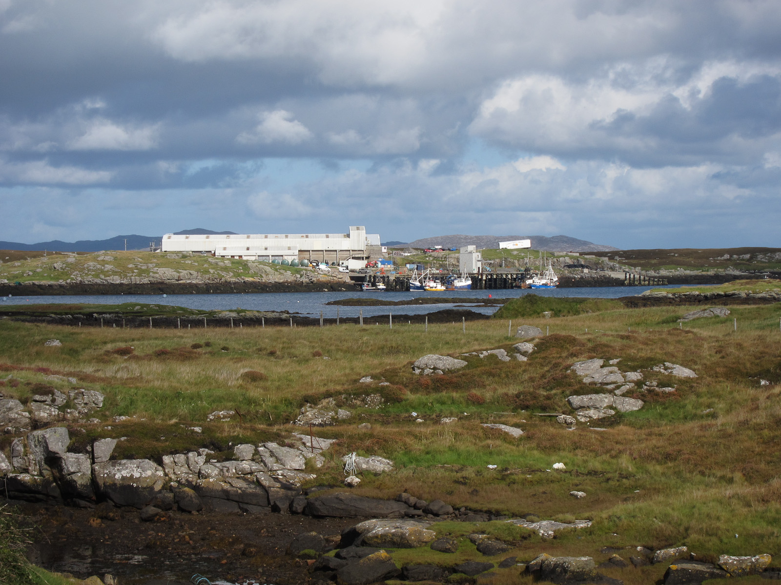
Àird Gheiltinis is a prominent coastal headland located in Inverness-shire, Scotland. Situated on the western coast, this point juts out into the Atlantic Ocean, offering breathtaking views and a rich natural environment.

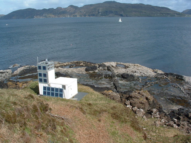
The headland is characterized by steep cliffs, which rise dramatically from the surrounding sea. These cliffs are composed of rugged rock formations, showcasing the area's geological history. The rock faces are often weathered and eroded, creating unique features and crevices that add to the headland's charm.

The area surrounding Àird Gheiltinis is abundant in diverse flora and fauna. The headland is home to various bird species, including seabirds such as gulls, cormorants, and puffins. Visitors can witness these birds in their natural habitat, making it a popular spot for birdwatching enthusiasts.

Moreover, the headland offers stunning panoramic views of the surrounding coastline, with its pristine beaches and crystal-clear waters. On a clear day, one can see the distant mountains and islands dotting the horizon. This picturesque landscape attracts not only nature lovers but also photographers and artists seeking inspiration.

Àird Gheiltinis is easily accessible by road, with a well-maintained path leading to the headland. There are also designated viewpoints and picnic areas for visitors to enjoy the scenery. It is advisable to wear sturdy footwear and take caution near the cliffs, as they can be treacherous.

Overall, Àird Gheiltinis is a magnificent coastal feature that showcases the natural beauty of Inverness-shire. Its striking cliffs, diverse wildlife, and stunning views make it a must-visit destination for anyone exploring the Scottish coast.

If you have any feedback on the listing, please let us know in the comments section below.

Àird Gheiltinis Images

Images are sourced within 2km of 57.012899/-7.418363 or Grid Reference NF7104. Thanks to Geograph Open Source API. All images are credited.

Moored at Àird Mhòr The 'SY' boat registration is for Stornoway.
Moored at Àird Mhòr
The 'SY' boat registration is for Stornoway.
Rocky foreshore at Àird Mhòr
The Barra to Eriskay ferry Standing just offshore between services.
The Barra to Eriskay ferry
Standing just offshore between services.
Departing from Barra On the Àird Mhòr to Eriskay ferry
Departing from Barra
On the Àird Mhòr to Eriskay ferry
Port Hand Channel Marker This marker emits a flashing red light every four seconds at night.  It marks a rocky area north-west of Lingeigh Fhada.
Port Hand Channel Marker
This marker emits a flashing red light every four seconds at night. It marks a rocky area north-west of Lingeigh Fhada.
Approaching Ardmhor View from the Eriskay ferry towards the harbour and ramp as the ferry approaches Ardmhor on Barra.
Approaching Ardmhor
View from the Eriskay ferry towards the harbour and ramp as the ferry approaches Ardmhor on Barra.
Whitehouse at Aird Mhidhinis The 'whitehouse' replaced the old drystone built and thatched 'blackhouse' in the Highlands and Islands.
Whitehouse at Aird Mhidhinis
The 'whitehouse' replaced the old drystone built and thatched 'blackhouse' in the Highlands and Islands.
Northbay road junction
Rivet on rock near Tràigh Mhòr, Barra Ordnance Survey benchmark on living rock near Barra's airport, described on database at <span class="nowrap"><a title="http://www.bench-marks.org.uk/bm76311" rel="nofollow ugc noopener" href="http://www.bench-marks.org.uk/bm76311">Link</a><img style="margin-left:2px;" alt="External link" title="External link - shift click to open in new window" src="https://s1.geograph.org.uk/img/external.png" width="10" height="10"/></span>.  Most of the benchmarks on the island are rivet types and have been placed in roadside living rocks. Not all of them are still extant. See also <a href="https://www.geograph.org.uk/photo/4996180">NF7004 : Rock showing rivet benchmark near Tràigh Mhòr, Barra</a>.
Rivet on rock near Tràigh Mhòr, Barra
Ordnance Survey benchmark on living rock near Barra's airport, described on database at LinkExternal link. Most of the benchmarks on the island are rivet types and have been placed in roadside living rocks. Not all of them are still extant. See also NF7004 : Rock showing rivet benchmark near Tràigh Mhòr, Barra.
Rock showing rivet benchmark near Tràigh Mhòr, Barra Ordnance Survey benchmark near the beach which serves as Barra's airport. See also <a href="https://www.geograph.org.uk/photo/4996176">NF7004 : Rivet on rock near Tràigh Mhòr, Barra</a>.
Rock showing rivet benchmark near Tràigh Mhòr, Barra
Ordnance Survey benchmark near the beach which serves as Barra's airport. See also NF7004 : Rivet on rock near Tràigh Mhòr, Barra.
Cut benchmark on St Barr Church, Northbay, Barra Ordnance Survey benchmark, described on database at <span class="nowrap"><a title="http://www.bench-marks.org.uk/bm76309" rel="nofollow ugc noopener" href="http://www.bench-marks.org.uk/bm76309">Link</a><img style="margin-left:2px;" alt="External link" title="External link - shift click to open in new window" src="https://s1.geograph.org.uk/img/external.png" width="10" height="10"/></span>. The only cut mark on the island.
Cut benchmark on St Barr Church, Northbay, Barra
Ordnance Survey benchmark, described on database at LinkExternal link. The only cut mark on the island.
Rivet in concrete drain surround near  Aird Mhidhinis, Barra Ordnance Survey rivet benchmark in drain surround near Barra's airport. For full description, see <span class="nowrap"><a title="http://www.bench-marks.org.uk/bm76313" rel="nofollow ugc noopener" href="http://www.bench-marks.org.uk/bm76313">Link</a><img style="margin-left:2px;" alt="External link" title="External link - shift click to open in new window" src="https://s1.geograph.org.uk/img/external.png" width="10" height="10"/></span>.
Rivet in concrete drain surround near Aird Mhidhinis, Barra
Ordnance Survey rivet benchmark in drain surround near Barra's airport. For full description, see LinkExternal link.
Rivet on rock near Bruairnis, Barra Ordnance Survey rivet benchmark on rock by side of road near turn off to Bruairnis. For full description, see <span class="nowrap"><a title="http://www.bench-marks.org.uk/bm76403" rel="nofollow ugc noopener" href="http://www.bench-marks.org.uk/bm76403">Link</a><img style="margin-left:2px;" alt="External link" title="External link - shift click to open in new window" src="https://s1.geograph.org.uk/img/external.png" width="10" height="10"/></span>.
Rivet on rock near Bruairnis, Barra
Ordnance Survey rivet benchmark on rock by side of road near turn off to Bruairnis. For full description, see LinkExternal link.
Waiting for the ferry at Ardmhor, Barra
Drying ground at Bagh Thiarabhagh
Beached boat, Northbay This might even be where an old boat goes to die.
Beached boat, Northbay
This might even be where an old boat goes to die.
Drying harbour at Thiarabhagh (Northbay) Vessels showing 'CY' for their registration port, Castlebay (although there is a Campbeltown, CN, boat there as well).
Drying harbour at Thiarabhagh (Northbay)
Vessels showing 'CY' for their registration port, Castlebay (although there is a Campbeltown, CN, boat there as well).
Through the hollow to the water There are not many trees on Barra, but there are a few here.
Through the hollow to the water
There are not many trees on Barra, but there are a few here.
Show me another place!

Àird Gheiltinis is located at Grid Ref: NF7104 (Lat: 57.012899, Lng: -7.418363)

Unitary Authority: Na h-Eileanan an Iar

Police Authority: Highlands and Islands

What 3 Words

///concerned.fabricate.mountain. Near CastleBay, Na h-Eileanan Siar

Related Wikis

Ardveenish

Ardveenish (Scottish Gaelic: Àird Mhèanais) is a village on Barra in the Western Isles, Scotland. Ardveenish is also within the parish of Barra. ��2�...

Ardmore, Barra

Ardmhor (Scottish Gaelic: Aird Mhòr) is a small village in the north east of the Isle of Barra in the Outer Hebrides, Scotland. In 2002 a small ferry port...

Northbay

Northbay (Scottish Gaelic: Am Bàgh a Tuath) is a township and community in the north of Barra in the Outer Hebrides, off the west coast of Scotland. Northbay...

Traigh Mhòr

The Tràigh Mhòr, in English 'Big Beach', is a large expanse of sand forming a magnificent white beach at the northern end of the island of Barra in the...

Related Videos

Outer Hebrides

Solo Bike trip to the Outer Hebrides from Falkirk, Oban, Barra, South & North Uist, Harris, Lewis, Ullapool, Inverness, Fort William, ...

What is the flight to Barra like? Includes landing at unique beach airport!

Become a SteveMarsh Supporter at: https://www.patreon.com/SteveMarsh Glasgow Airport is the departure point for one of the ...

Traigh Mhòr Beach And Airport On History Visit To Island Of Barra Outer Hebrides Scotland

Tour Scotland short travel video clip, with Scottish music, of Traigh Mhòr beach and airport, Gaelic: Port-adhair Bharraigh, on ...

A Beach Airport & 350 passengers berried in the sand dunes on Vatersay. Vango F10 tent Wild camping

Mosquito Repellent Bracelet 10 PACK @ https://amzn.to/2Xg716r Citronella Incense Sticks @ https://amzn.to/2IT1ZnC You can ...

Nearby Amenities

Located within 500m of 57.012899,-7.418363
Passing Place
Source: Bing
Lat/Long: 57.011089/-7.4252767
Passing Place
Source: Bing
Lat/Long: 57.009206/-7.4211984
Àird Mhòr
Name En: Ardmore
Name Gd: Àird Mhòr
Place: village
Wikidata: Q4788186
Wikipedia: en:Ardmore, Barra
Lat/Long: 57.0097987/-7.4230671
Power: pole
Lat/Long: 57.0119236/-7.4263555
Power: pole
Lat/Long: 57.0115001/-7.4251659
Power: pole
Lat/Long: 57.0108495/-7.4243733
Power: pole
Lat/Long: 57.0104478/-7.4237551
Power: pole
Lat/Long: 57.0100667/-7.423165
Power: pole
Lat/Long: 57.0096095/-7.4224636
Power: pole
Lat/Long: 57.0094241/-7.4216858
Power: pole
Lat/Long: 57.0092357/-7.420857
Power: pole
Lat/Long: 57.0091473/-7.4195869
Power: pole
Lat/Long: 57.0091115/-7.4190344
Power: pole
Lat/Long: 57.0087937/-7.4178549
Barrier: cattle_grid
Lat/Long: 57.0089289/-7.4206398
The data included in this document is from www.openstreetmap.org. The data is made available under ODbL.

Have you been to Àird Gheiltinis?

Leave your review of Àird Gheiltinis below (or comments, questions and feedback).