An Àird

Coastal Feature, Headland, Point in Inverness-shire

Scotland

An Àird

Sotun Summit, Berneray/Bearnaraigh A five island expedition from Castlebay on Boy James. This is a picture of the misty grassy summit of Berneray/Bearnaraigh called Sotan. Although a rock 2 metres north of lighthouse perimeter wall at NL 54867 80229 is highest point but not yet officially ratified.
Name: Sotan
Hill number: 1632
Height: 193m / 633ft
Area: 24D: Barra to Barra Head
Class: Ma,1
Grid ref: NL 55353 79980
Summit feature: no feature
Drop: 193m
Col: Sea
Sotun Summit, Berneray/Bearnaraigh Credit: Rude Health

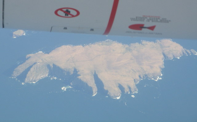
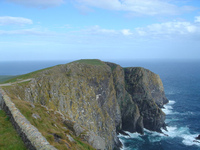
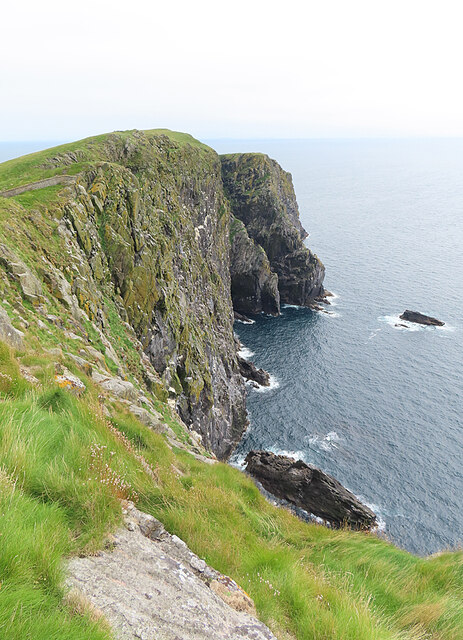
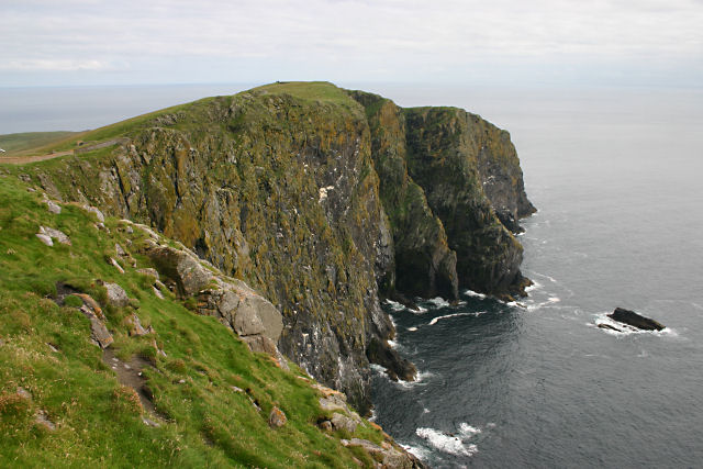
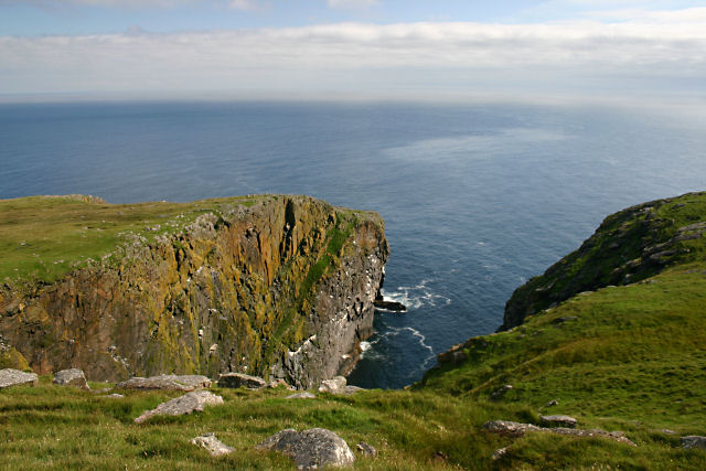
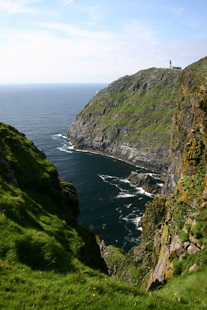
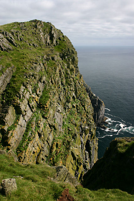
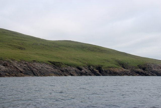
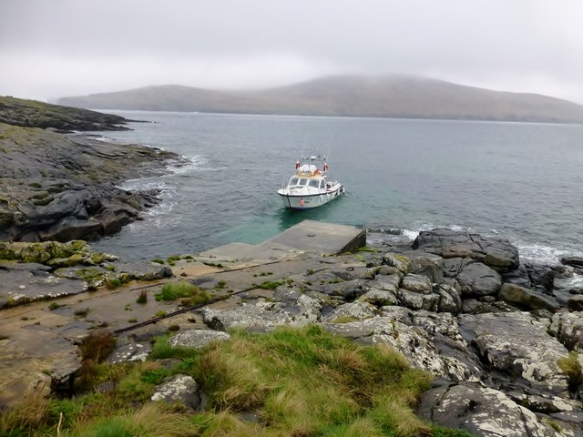
An Àird is a prominent coastal feature located in Inverness-shire, Scotland. Situated on the western coast of the country, it is a headland that juts out into the North Atlantic Ocean. This rugged and picturesque point offers breathtaking views of the surrounding landscape and nearby islands.

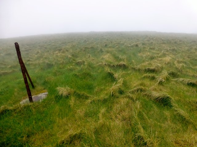
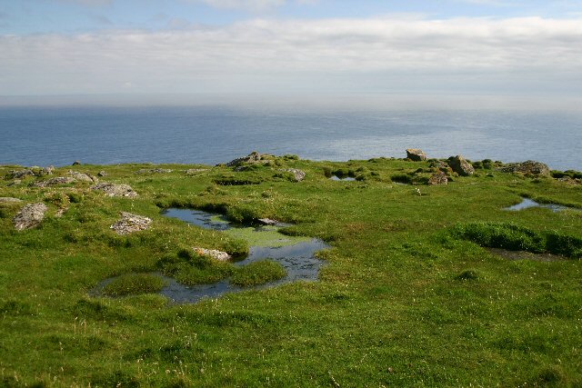
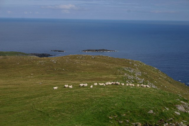
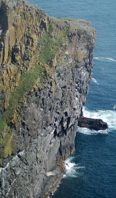
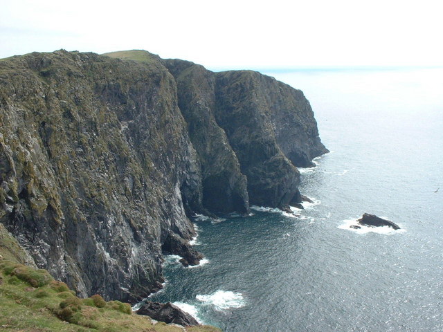
The terrain of An Àird is characterized by steep cliffs, which provide a dramatic backdrop against the crashing waves below. The headland is covered in lush vegetation, including grasses, heather, and various wildflowers, adding to its natural beauty. The area is also home to a diverse range of wildlife, including seabirds, seals, and occasionally dolphins, making it an ideal spot for birdwatching and marine life observation.

An Àird is a popular destination for outdoor enthusiasts and nature lovers alike. Visitors can explore the headland by following well-marked trails that wind their way around the coastline. These paths offer stunning panoramic views of the ocean and surrounding landscape, providing ample opportunities for photography and relaxation.

For history enthusiasts, An Àird also holds significance. The area is dotted with remnants of ancient settlements and archaeological sites, including Iron Age forts and burial mounds. These historical landmarks offer a glimpse into the rich past of the region, adding an additional layer of intrigue to the natural beauty of the headland.

In conclusion, An Àird in Inverness-shire is a captivating coastal feature that combines stunning vistas, diverse wildlife, and a rich historical heritage. Its rugged cliffs, picturesque trails, and archaeological sites make it a must-visit destination for anyone seeking to immerse themselves in the beauty and history of Scotland's western coast.

If you have any feedback on the listing, please let us know in the comments section below.

An Àird Images

Images are sourced within 2km of 56.785691/-7.6166401 or Grid Reference NL5780. Thanks to Geograph Open Source API. All images are credited.

Sotun Summit, Berneray/Bearnaraigh A five island expedition from Castlebay on Boy James. This is a picture of the misty grassy summit of Berneray/Bearnaraigh called Sotan. Although a rock 2 metres north of lighthouse perimeter wall at NL 54867 80229 is highest point but not yet officially ratified.
Name: Sotan
Hill number: 1632
Height: 193m / 633ft
Area: 24D: Barra to Barra Head
Class: Ma,1
Grid ref: NL 55353 79980
Summit feature: no feature
Drop: 193m
Col: Sea
Sotun Summit, Berneray/Bearnaraigh
A five island expedition from Castlebay on Boy James. This is a picture of the misty grassy summit of Berneray/Bearnaraigh called Sotan. Although a rock 2 metres north of lighthouse perimeter wall at NL 54867 80229 is highest point but not yet officially ratified. Name: Sotan Hill number: 1632 Height: 193m / 633ft Area: 24D: Barra to Barra Head Class: Ma,1 Grid ref: NL 55353 79980 Summit feature: no feature Drop: 193m Col: Sea
Berneray/Bearnaraigh - an aerial view from the south From about 36000ft heading west, about 30min after leaving Edinburgh
Berneray/Bearnaraigh - an aerial view from the south
From about 36000ft heading west, about 30min after leaving Edinburgh
Sotan, Berneray Seen from near the lighthouse. Sotan is a couple of metres higher than the lighthouse, and the highest point of the island.
Sotan, Berneray
Seen from near the lighthouse. Sotan is a couple of metres higher than the lighthouse, and the highest point of the island.
Sloc na Sealbhaig The precipitous cliffs east of the lighthouse on Berneray.
Sloc na Sealbhaig
The precipitous cliffs east of the lighthouse on Berneray.
Mullach a' Lusgan, Berneray These rock pools are on top of the cliffs at Barra Head, the southernmost point of the Outer Hebrides.
Mullach a' Lusgan, Berneray
These rock pools are on top of the cliffs at Barra Head, the southernmost point of the Outer Hebrides.
Cuiveg Point, Berneray In Gaelic, 'Rubha Cuabhaig', this south-eastern tip of Berneray is populated only by a flock of extremely shaggy sheep.
Cuiveg Point, Berneray
In Gaelic, 'Rubha Cuabhaig', this south-eastern tip of Berneray is populated only by a flock of extremely shaggy sheep.
Rubha Ghralish, Berneray The seabird cliffs at Rubha Ghralish
Rubha Ghralish, Berneray
The seabird cliffs at Rubha Ghralish
Sloc na Sealbhaig This inlet is at the foot of the 180m cliffs to the south east of the lighthouse. Just round the cliffs is Barra Head, the most southerly point on Berneray, which is the most southerly island in the Outer Hebrides (not on Barra at all).
Sloc na Sealbhaig
This inlet is at the foot of the 180m cliffs to the south east of the lighthouse. Just round the cliffs is Barra Head, the most southerly point on Berneray, which is the most southerly island in the Outer Hebrides (not on Barra at all).
Barra Head, Berneray The southernmost point of the Outer Hebrides.
Barra Head, Berneray
The southernmost point of the Outer Hebrides.
Sloc Voacligeo, Berneray This inlet lies to the west of Barra Head.
Sloc Voacligeo, Berneray
This inlet lies to the west of Barra Head.
Sloc na Sealbhaig, Berneray Steep cliffs on Berneray's southern coast. The lighthouse at Skate Point can be seen in the distance.
Sloc na Sealbhaig, Berneray
Steep cliffs on Berneray's southern coast. The lighthouse at Skate Point can be seen in the distance.
Headland immediately west of Barra Head, Berneray Almost the southernmost tip of the Outer Hebrides (Barra Head, just to the east, is the southernmost point).
Headland immediately west of Barra Head, Berneray
Almost the southernmost tip of the Outer Hebrides (Barra Head, just to the east, is the southernmost point).
A gentler side of Mingulay Good grazing for cattle during its years of human occupation
A gentler side of Mingulay
Good grazing for cattle during its years of human occupation
Pier At Berneray/Bearnaraigh Thirteen Marilyn baggers were dropped of at this rather slippy pier to explore this lovely island of Berneray/Bearnaraigh. This pier helped service the lighthouse.
Pier At Berneray/Bearnaraigh
Thirteen Marilyn baggers were dropped of at this rather slippy pier to explore this lovely island of Berneray/Bearnaraigh. This pier helped service the lighthouse.
Well On Berneray/Bearnaraigh A view into the well on Berneray/Bearnaraigh plus the wall behind it which attempts to enclose the well.
Well On Berneray/Bearnaraigh
A view into the well on Berneray/Bearnaraigh plus the wall behind it which attempts to enclose the well.
Walled Well Enclosure A view back up the track to the lighthouse on Berneray/Bearnaraigh with the walled well enclosure on the left of the track.
Walled Well Enclosure
A view back up the track to the lighthouse on Berneray/Bearnaraigh with the walled well enclosure on the left of the track.
Burial Ground, Berneray This walled burial ground is situated halfway between the Barra Head Lighthouse and Sotan, the highest point on Berneray at 193 metres. The memorials in the burial ground are poignant reminders of the hazards of living on such a remote island, with several children having died at an early age.
Burial Ground, Berneray
This walled burial ground is situated halfway between the Barra Head Lighthouse and Sotan, the highest point on Berneray at 193 metres. The memorials in the burial ground are poignant reminders of the hazards of living on such a remote island, with several children having died at an early age.
Berneray jetty This jetty was built in the 1830s to service the lighthouse on Barra Head.  A track leads from the jetty up to the lighthouse, a mile and a quarter away.  The island behind is Mingulay.
Berneray jetty
This jetty was built in the 1830s to service the lighthouse on Barra Head. A track leads from the jetty up to the lighthouse, a mile and a quarter away. The island behind is Mingulay.
Show me another place!

An Àird is located at Grid Ref: NL5780 (Lat: 56.785691, Lng: -7.6166401)

Unitary Authority: Na h-Eileanan an Iar

Police Authority: Highlands and Islands

What 3 Words

///classmate.moped.tanks. Near CastleBay, Na h-Eileanan Siar

Related Wikis

Barra Head

Barra Head, also known as Berneray (Scottish Gaelic: Beàrnaraigh; Scots: Barra Heid), is the southernmost island of the Outer Hebrides in Scotland. Within...

Barra Head Lighthouse

Barra Head Lighthouse on Barra Head identifies the southern entrance to The Minch, roughly halfway between the Eilean Glas and Rinns of Islay lighthouses...

Barra Isles

The Barra Isles, also known as the Bishop's Isles, are a small archipelago in the Outer Hebrides of Scotland. They lie south of the island of Barra, for...

Mingulay

Mingulay (Scottish Gaelic: Miughalaigh) is the second largest of the Bishop's Isles in the Outer Hebrides of Scotland. Located 12 nautical miles (22 kilometres...

Nearby Amenities

Located within 500m of 56.785691,-7.6166401
An Àird
Natural: cape
Source: OS_OpenData_StreetView
Lat/Long: 56.7856173/-7.6176481
Man Made: water_well
Lat/Long: 56.787109/-7.6219189
Historic: archaeological_site
Lat/Long: 56.7873239/-7.6236615
Natural: rock
Lat/Long: 56.7858628/-7.6185673
Natural: rock
Lat/Long: 56.7861357/-7.6179832
Natural: rock
Lat/Long: 56.7875311/-7.6227844
Natural: rock
Lat/Long: 56.7875553/-7.6228125
Natural: rock
Lat/Long: 56.7871032/-7.6192512
Natural: rock
Lat/Long: 56.7846138/-7.6223535
Natural: rock
Lat/Long: 56.78357/-7.6234496
Natural: rock
Lat/Long: 56.7833085/-7.6224209
Natural: rock
Lat/Long: 56.783246/-7.6226342
Natural: rock
Lat/Long: 56.7832328/-7.6226717
Natural: rock
Lat/Long: 56.7861978/-7.6228937
The data included in this document is from www.openstreetmap.org. The data is made available under ODbL.

Have you been to An Àird?

Leave your review of An Àird below (or comments, questions and feedback).