Becky's Wood

Wood, Forest in Norfolk South Norfolk

England

Becky's Wood

Winfarthing: The Old Parsonage
Winfarthing: The Old Parsonage Credit: Michael Garlick

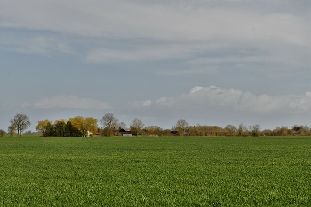
Becky's Wood is a picturesque woodland located in Norfolk, England. Spanning over 100 acres, this enchanting forest offers a serene and peaceful retreat for nature enthusiasts and outdoor lovers alike. The wood is named after Becky, a local naturalist who played a significant role in its preservation and conservation.

Dominated by a diverse range of tree species, including oak, ash, beech, and birch, Becky's Wood boasts an impressive canopy that provides a cool and shaded atmosphere during the summer months. The forest floor is adorned with a rich tapestry of wildflowers, creating a vibrant and colorful display throughout the year.

Tranquil walking trails wind their way through the wood, allowing visitors to explore its hidden gems and discover the abundant wildlife that calls this place home. Birdwatchers will be delighted by the variety of avian species that inhabit the area, including woodpeckers, thrushes, and various birds of prey.

Becky's Wood is also home to a small, crystal-clear stream that meanders through the forest. This babbling brook adds to the natural charm and provides a soothing soundtrack for those seeking a moment of tranquility.

The wood is open to the public year-round, with designated picnic areas and benches scattered throughout, allowing visitors to relax and soak in the peaceful surroundings. Whether you are looking for a leisurely stroll, a spot for a picnic, or a chance to reconnect with nature, Becky's Wood offers a truly idyllic escape from the hustle and bustle of everyday life.

If you have any feedback on the listing, please let us know in the comments section below.

Becky's Wood Images

Images are sourced within 2km of 52.4315/1.1005543 or Grid Reference TM1086. Thanks to Geograph Open Source API. All images are credited.

Winfarthing: The Old Parsonage
Winfarthing, St. Mary's Church: Northern aspect
Winfarthing: The end of Church Lane
Winfarthing: Gated track leading to Park Farm
Winfarthing: Church Lane and St. Mary's Church
Goose Green: Agricultural land
Shelfanger: 'Kimmeridge'
Winfarthing, St. Mary's Church: The font, a Victorian bowl on a Norman stem
Winfarthing, St. Mary's Church: Memorial for Samuel Whitbread-Bourne and his wife
Winfarthing, St. Mary's Church: First World War memorial
Winfarthing, St. Mary's Church: John Edwards memorial
Winfarthing, St. Mary's Church: The pulpit
Winfarthing, St. Mary's Church: The pulpit (detail)
Winfarthing, St. Mary's Church: North window by Brian Fielden 1957
Winfarthing, St. Mary's Church: North window by Brian Fielden 1957 (detail) 1
Winfarthing, St. Mary's Church: North window by Brian Fielden 1957 (detail) 2 The 'Sword of Winfarthing'
Winfarthing, St. Mary's Church: North window by Brian Fielden 1957 (detail) 2
The 'Sword of Winfarthing'
Winfarthing, St. Mary's Church: Arthur Edward Church memorial
Winfarthing, St. Mary's Church: The nave from the chancel
Show me another place!

Becky's Wood is located at Grid Ref: TM1086 (Lat: 52.4315, Lng: 1.1005543)

Administrative County: Norfolk

District: South Norfolk

Police Authority: Norfolk

Also known as: Tracey's Wood

What 3 Words

///unusually.durations.comply. Near Banham, Norfolk

Related Wikis

Winfarthing

Winfarthing is a village and civil parish in the English county of Norfolk. It is located 6 km (4 mi) north of the town of Diss, 20 km (12 mi) east of...

Heywood, Norfolk

Heywood is a civil parish in the English county of Norfolk. It was formed in 2003 from a part of the parish of Diss. It covers an area of 9.56 km2 (3.69...

Shelfanger

Shelfanger is a village situated about 3 miles from the town of Diss in Norfolk, England. There is a church and a village hall in the village. It covers...

RAF Fersfield

Royal Air Force Fersfield or more simply RAF Fersfield (originally known as RAF Winfarthing) is a former Royal Air Force station located 16 miles (26 km...

Nearby Amenities

Located within 500m of 52.4315,1.1005543
Lodge Farm, opp
Naptan AtcoCode: 2900W3511
Naptan Bearing: SW
Naptan BusStopType: CUS
Naptan CommonName: Lodge Farm
Naptan Indicator: opp
Naptan Landmark: Lodge Drive
Naptan Locality: Winfarthing
Naptan NaptanCode: nfogdtam
Naptan Street: Hall Road
Naptan Verified: no
Source: naptan_import
Lat/Long: 52.435891/1.0992436
Phone Box, opp
Naptan AtcoCode: 2900W3512
Naptan Bearing: SE
Naptan BusStopType: CUS
Naptan CommonName: Phone Box
Naptan Indicator: opp
Naptan Landmark: Orchard House
Naptan Locality: Winfarthing
Naptan NaptanCode: nfogdtap
Naptan Street: The Street
Naptan Verified: no
Source: naptan_import
Lat/Long: 52.4305184/1.0979983
Fighting Cocks, opp
Naptan AtcoCode: 2900W3513
Naptan Bearing: SE
Naptan BusStopType: CUS
Naptan CommonName: Fighting Cocks
Naptan Indicator: opp
Naptan Landmark: Fighting Cocks Public House
Naptan Locality: Winfarthing
Naptan NaptanCode: nfogdtat
Naptan Street: The Street
Naptan Verified: no
Source: naptan_import
Lat/Long: 52.4295636/1.0987405
Chapel Close, opp
Naptan AtcoCode: 2900W3514
Naptan Bearing: S
Naptan BusStopType: CUS
Naptan CommonName: Chapel Close
Naptan Indicator: opp
Naptan Landmark: Chapel Close
Naptan Locality: Winfarthing
Naptan NaptanCode: nfogdtaw
Naptan Street: Hall Road
Naptan Verified: no
Source: naptan_import
Lat/Long: 52.4335647/1.0977559
Phone Box, adj
Naptan AtcoCode: 2900W354
Naptan Bearing: NW
Naptan BusStopType: CUS
Naptan CommonName: Phone Box
Naptan Indicator: adj
Naptan Landmark: Hall Road Junction
Naptan Locality: Winfarthing
Naptan NaptanCode: nfogdtdj
Naptan Street: The Street
Naptan Verified: no
Source: naptan_import
Lat/Long: 52.4305238/1.0977927
Fighting Cocks, adj
Naptan AtcoCode: 2900W355
Naptan Bearing: NW
Naptan BusStopType: CUS
Naptan CommonName: Fighting Cocks
Naptan Indicator: adj
Naptan Landmark: Fighting Cocks Public House
Naptan Locality: Winfarthing
Naptan NaptanCode: nfogdtdm
Naptan Street: The Street
Naptan Verified: no
Source: naptan_import
Lat/Long: 52.429612/1.0986115
Chapel Close, adj
Naptan AtcoCode: 2900W358
Naptan Bearing: N
Naptan BusStopType: CUS
Naptan CommonName: Chapel Close
Naptan Indicator: adj
Naptan Landmark: Chapel Close
Naptan Locality: Winfarthing
Naptan NaptanCode: nfogdtdp
Naptan Street: Hall Road
Naptan Verified: no
Source: naptan_import
Lat/Long: 52.4335666/1.0976825
Board Type: notice
Description: Please use the driveway
Information: board
Tourism: information
Lat/Long: 52.4272956/1.1007168
Barrier: stile
Lat/Long: 52.4295528/1.1011824
Winfarthing
Place: village
Source: OS 1:25k
Lat/Long: 52.4300729/1.1001241
Barrier: stile
Bicycle: no
Foot: yes
Material: metal
Stile: squeezer
Lat/Long: 52.4273729/1.1024798
Bench
Backrest: yes
Material: wood
Seats: 3
Lat/Long: 52.4288304/1.1019675
Waste Basket
Lat/Long: 52.4284792/1.1000011
Notice Board
Lat/Long: 52.4285031/1.1000517
Traffic Calming: hump
Lat/Long: 52.4285329/1.1000684
Bench
Backrest: yes
Material: wood
Seats: 3
Lat/Long: 52.4284794/1.1000256
Winfarthing
Colour: brown;green;blue
Inscription: E R / I / E R / II
Man Made: village_sign
Material: wood
Lat/Long: 52.4284609/1.1000575
Description: Elaborate carved stone frame around engraved marble slab. On inside wall of the church.
Historic: memorial
Inscription: In Loving Memory of the Men of Winfarthing Who Fell in the Great War 1914 - 1919 (12 Mens names listed).
Memorial: plaque
Website: https://www.gravestonephotos.com/public/cemetery.php?cemetery=4230&scrwidth=1200
Lat/Long: 52.4287655/1.1011009
Fixme: New houses here to survey and add, and extend of residential area needs confirming
Lat/Long: 52.433646/1.096803
Note: Path cut through crop ends at a dead end here 2017-05
Lat/Long: 52.4309725/1.0959265
Barrier: stile
Lat/Long: 52.4352732/1.1007935
Barrier: stile
Lat/Long: 52.432212/1.1004455
Barrier: stile
Lat/Long: 52.4352848/1.1008079
Board Type: notice
Information: board
Tourism: information
Lat/Long: 52.4286903/1.1004413
Give Way
Direction: backward
Lat/Long: 52.4284961/1.0998811
Board Type: notice
Information: board
Tourism: information
Lat/Long: 52.4284994/1.100053
Waste Basket
Lat/Long: 52.428483/1.0999833
Bench
Backrest: yes
Lat/Long: 52.428479/1.1000155
Entrance: main
Lat/Long: 52.4287872/1.1010674
Defibrillator
Defibrillator Location: Mounted on external wall of The Fighting Cocks pub
Emergency: defibrillator
Indoor: no
Ref GB The Circuit: D76058BC-4C6F-4F80-80C0-AD80013BD133
Lat/Long: 52.4293028/1.0987656
The data included in this document is from www.openstreetmap.org. The data is made available under ODbL.

Have you been to Becky's Wood?

Leave your review of Becky's Wood below (or comments, questions and feedback).