An Fhùirneis

Settlement in Argyllshire

Scotland

An Fhùirneis

The A83 coming in to Furnace, Argyll
The A83 coming in to Furnace, Argyll Credit: Alpin Stewart

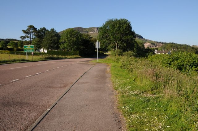
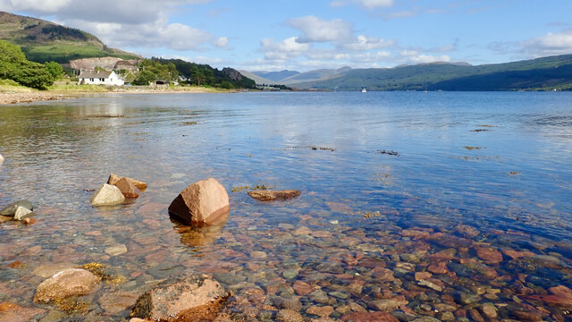
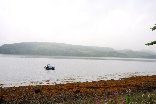
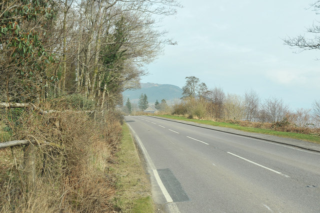
An Fhùirneis, also known as Furnace, is a small village located in Argyllshire, Scotland. Situated on the western coast, it is nestled between the towns of Inveraray and Lochgilphead. The village is surrounded by picturesque landscapes, with rolling hills and stunning views of Loch Fyne.

An Fhùirneis has a population of around 500 residents. It is a tight-knit community, known for its friendly atmosphere and strong sense of community spirit. The village has a primary school, a village hall, and a local shop that caters to the everyday needs of the residents.

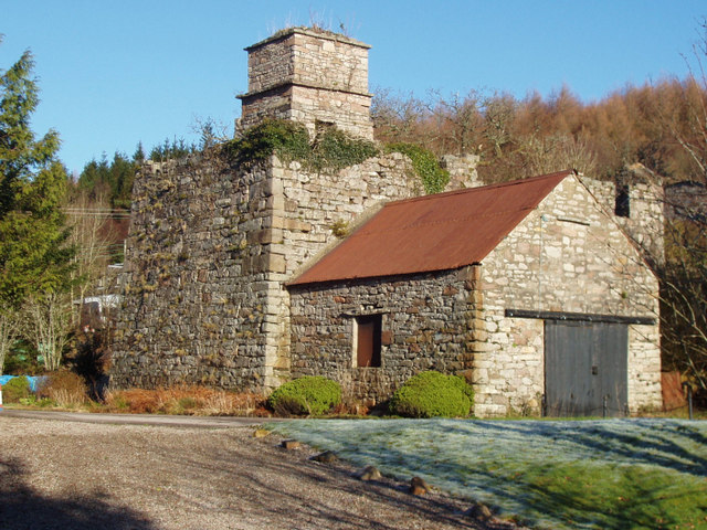
Historically, An Fhùirneis was an important industrial hub in the 18th and 19th centuries. It was famous for its ironworks, which played a significant role in the local economy. Today, remnants of the ironworks can still be seen, adding to the village's historical charm.

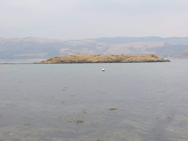
The village offers a range of outdoor activities for residents and visitors alike. Loch Fyne provides opportunities for fishing, sailing, and water sports, while the nearby hills and forests offer hiking and biking trails. The idyllic surroundings make An Fhùirneis a popular destination for nature lovers and those seeking tranquility.

In terms of tourism, An Fhùirneis attracts visitors who appreciate its natural beauty and historical significance. The village offers a few bed and breakfast accommodations and self-catering cottages, providing visitors with a comfortable stay amidst the stunning Scottish countryside.

An Fhùirneis, with its rich history, beautiful landscapes, and welcoming community, truly captures the essence of rural Scotland. It is a place where residents and visitors can enjoy the tranquility of nature while immersing themselves in the local heritage.

If you have any feedback on the listing, please let us know in the comments section below.

An Fhùirneis Images

Images are sourced within 2km of 56.152488/-5.1837708 or Grid Reference NN0200. Thanks to Geograph Open Source API. All images are credited.

The A83 coming in to Furnace, Argyll
Burn flowing into Whitebridge Bay The Allt an Bhocain adds a little water to Loch Fyne. The strong young shoots appearing are of a Polygonum.
Burn flowing into Whitebridge Bay
The Allt an Bhocain adds a little water to Loch Fyne. The strong young shoots appearing are of a Polygonum.
White Bridge Cottage On the A83 running along the west side of Loch Fyne.
White Bridge Cottage
On the A83 running along the west side of Loch Fyne.
Old Milestone by the A83, Whitebridge Bay, Kilmichael Glassary parish Stone post by the A83, in parish of Kilmichael Glassary (Argyll and Bute District), Whitebridge Bay, in low wall in front of modern bungalow.

Inscription reads:-
9
(To Inveraray)

Surveyed

Milestone Society National ID: AB_IYLG09
Old Milestone by the A83, Whitebridge Bay, Kilmichael Glassary parish
Stone post by the A83, in parish of Kilmichael Glassary (Argyll and Bute District), Whitebridge Bay, in low wall in front of modern bungalow. Inscription reads:- 9 (To Inveraray) Surveyed Milestone Society National ID: AB_IYLG09
Old Milestone by the A83, Furnace, Kilmichael Glassary parish Stone post by the A83, in parish of Kilmichael Glassary (Argyll and Bute District), Furnace, near Firtree, North side of road.

Inscription reads:-
8
(To Inveraray)

Surveyed

Milestone Society National ID: AB_IYLG08
Old Milestone by the A83, Furnace, Kilmichael Glassary parish
Stone post by the A83, in parish of Kilmichael Glassary (Argyll and Bute District), Furnace, near Firtree, North side of road. Inscription reads:- 8 (To Inveraray) Surveyed Milestone Society National ID: AB_IYLG08
The A83 entering Furnace The A83 entering Furnace beside Long Fyne.
The A83 entering Furnace
The A83 entering Furnace beside Long Fyne.
Tail of a thunder shower at Furnace
Loch Fyne at Furnace
Loch Fyne Shore The shoreline between Sandhole and Furnace.
Loch Fyne Shore
The shoreline between Sandhole and Furnace.
Loch Fyne Mooring A small boat moored by the shore near Sandhole.
Loch Fyne Mooring
A small boat moored by the shore near Sandhole.
Sheep by Sandhole Sheep grazing in a field between Sandhole and Furnace.
Sheep by Sandhole
Sheep grazing in a field between Sandhole and Furnace.
A Fyne Boat At Furnace A small boat moored in Loch Fyne at Furnace.
A Fyne Boat At Furnace
A small boat moored in Loch Fyne at Furnace.
A83 at Sandhole
A83 at Sandhole
A83 near Sandhole
A83 near Sandhole
Woodland track near Sandhole
A83 near Sandhole
A83 near Sandhole
Eilean Math-ghamhna or Newton Island as the locals call it
Wooded shoreline of Loch Fyne
Show me another place!

An Fhùirneis is located at Grid Ref: NN0200 (Lat: 56.152488, Lng: -5.1837708)

Unitary Authority: Argyll and Bute

Police Authority: Argyll and West Dunbartonshire

Also known as: Inverleacainn, Furness

What 3 Words

///accordion.foiled.singers. Near Inveraray, Argyll & Bute

Related Wikis

Furnace, Argyll

Furnace (Scottish Gaelic: An Fhùirneis) (formerly Inverleacainn (Scottish Gaelic: Inbhir Leacainn)) is a village in Argyll and Bute, on the west coast...

Auchindrain

Auchindrain (Scottish Gaelic: Achadh an Droighinn: 'thorn field') lies on the A83, 6 miles (10 km) south of Inveraray in Argyll and Bute, Scotland. It...

Crarae

Crarae is a settlement in Argyll and Bute, Scotland, on the shore of Loch Fyne. It lies on the A83, north of Lochgilphead. The location is known for the...

New Castle Lachlan

New Castle Lachlan, is an 18th-century baronial mansion or country house located at Strathlachlan, Cowal peninsula, Argyll and Bute, Scotland. It was built...

Crarae Reservoir

The Crarae Reservoir is located 2.5 kilometres north west of the village of Crarae, on the west side of Loch Fyne. The concrete dam is 13.7 metres high...
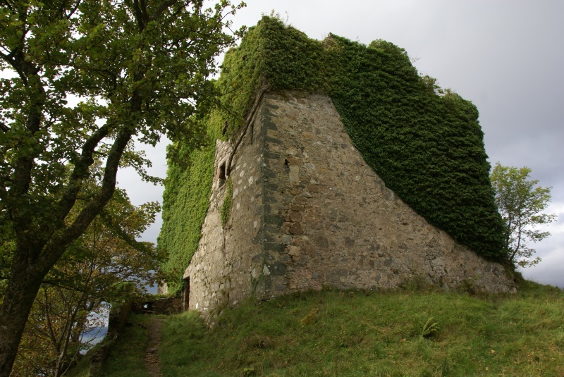
Old Castle Lachlan

Old Castle Lachlan, also known as Castle Lachlan, is a ruined 15th-century castle on the shore of Loch Fyne, within the Cowal Peninsula, in Argyll and...

Loch Fyne

Loch Fyne (Scottish Gaelic: Loch Fìne, pronounced [l̪ˠɔx ˈfiːnə]; meaning "Loch of the Vine/Wine"), is a sea loch off the Firth of Clyde and forms part...
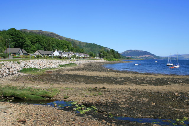
Minard, Argyll

Minard is a remote village on the western shore of Loch Fyne, situated between Inveraray and Lochgilphead. Minard is 13+1⁄2 miles (21.7 km) southwest of...

Nearby Amenities

Located within 500m of 56.152488,-5.1837708
Created By: dmgroom_coastlines
Source: PGS
Lat/Long: 56.1496758/-5.189938
Created By: dmgroom_coastlines
Source: PGS
Lat/Long: 56.1495638/-5.189013
Created By: dmgroom_coastlines
Source: PGS
Lat/Long: 56.1495718/-5.188555
Created By: dmgroom_coastlines
Source: PGS
Lat/Long: 56.1497038/-5.188334
Created By: dmgroom_coastlines
Source: PGS
Lat/Long: 56.1498358/-5.188111
Created By: dmgroom_coastlines
Source: PGS
Lat/Long: 56.1501158/-5.18675
Created By: dmgroom_coastlines
Source: PGS
Lat/Long: 56.1501568/-5.184458
Created By: dmgroom_coastlines
Source: PGS
Lat/Long: 56.1501648/-5.184
Created By: dmgroom_coastlines
Source: PGS
Lat/Long: 56.1502968/-5.183779
Created By: dmgroom_coastlines
Source: PGS
Lat/Long: 56.1504288/-5.183556
Created By: dmgroom_coastlines
Source: PGS
Lat/Long: 56.1504848/-5.180347
Created By: dmgroom_coastlines
Source: PGS
Lat/Long: 56.1505098/-5.178972
Created By: dmgroom_coastlines
Source: PGS
Lat/Long: 56.1507978/-5.177153
Created By: dmgroom_coastlines
Source: PGS
Lat/Long: 56.1509418/-5.176243
Created By: dmgroom_coastlines
Source: PGS
Lat/Long: 56.1514538/-5.176272
Furnace
Name En: Furnace
Name Gd: An Fhùirneis
Place: village
Wikidata: Q1002171
Wikipedia: en:Furnace, Argyll
Lat/Long: 56.1525021/-5.1837044
Post Office
Furnace Stores
Brand: Post Office
Brand Wikidata: Q1783168
Website: https://www.postoffice.co.uk/branch-finder/1778587/furnace
Lat/Long: 56.1524529/-5.1843241
Townhall
Furnace Village Hall
Operator: Furnace Amenity Assn.
Lat/Long: 56.1525485/-5.1839914
Telephone
Booth: K6
Covered: booth
Lat/Long: 56.1527025/-5.1829724
Bus Stop
Furnace, Village Hall
Naptan AtcoCode: 60709305
Naptan NaptanCode: 54723734
Shelter: yes
Lat/Long: 56.1525561/-5.1838656
Pub
The Furnace Inn
Lat/Long: 56.1525829/-5.1829134
Post Box
Post Box Type: pillar
Ref: PA32 47
Royal Cypher: GR
Royal Cypher Wikidata: Q33102273
Lat/Long: 56.1525016/-5.1839595
Furnace War Memorial
Historic: memorial
Memorial: war_memorial
Wikidata: Q114169228
Lat/Long: 56.1526091/-5.1836429
Craleckan Ironworks
Heritage: yes
Heritage Operator: Historic Environment Scotland
Heritage Website: https://portal.historicenvironment.scot/designation/SM2530
Historic: ruins
Ref GB Hs: SM2530
Ref Canmore: 23401
Wikidata: Q56667419
Lat/Long: 56.1522057/-5.1801811
Powdermills B&B
Guest House: bed_and_breakfast
Tourism: guest_house
Lat/Long: 56.1542449/-5.1851633
Historic: ruins
Lat/Long: 56.1537668/-5.1854396
Historic: ruins
Lat/Long: 56.1564453/-5.185563
Historic: ruins
Lat/Long: 56.1560375/-5.1858459
Gunpowder Works
Heritage Operator: Historic Environment Scotland
Heritage Website: https://portal.historicenvironment.scot/designation/SM5813
Historic: ruins
Ref GB Hs: SM5813
Ref Canmore: 23403
Wikidata: Q56663886
Lat/Long: 56.1552443/-5.1861557
Historic: ruins
Lat/Long: 56.1550101/-5.1873627
Bench
Lat/Long: 56.1548831/-5.1864458
Bench
Lat/Long: 56.1549001/-5.1864243
Bench
Lat/Long: 56.1549724/-5.1874144
The data included in this document is from www.openstreetmap.org. The data is made available under ODbL.

Have you been to An Fhùirneis?

Leave your review of An Fhùirneis below (or comments, questions and feedback).