Foxburrow Wood

Wood, Forest in Suffolk East Suffolk

England

Foxburrow Wood

Farmland and pylons Near burnt House Farm.
Farmland and pylons Credit: JThomas

Foxburrow Wood is a picturesque woodland located in Suffolk, England. Covering an area of approximately 28 hectares, the wood is a part of the Suffolk Wildlife Trust's nature reserve network. It is situated in the village of Melton, near the larger town of Woodbridge.

This ancient woodland is predominantly composed of oak and birch trees, interspersed with patches of hazel and holly. The dense canopy provides a rich habitat for a diverse range of flora and fauna. Bluebells, wood anemones, and primroses carpet the forest floor during spring, creating a vibrant display of colors.

The wood is crisscrossed by a network of well-maintained footpaths, offering visitors the opportunity to explore its natural beauty up close. These paths lead to various viewpoints, where one can enjoy panoramic views of the surrounding countryside. The reserve also boasts a small pond, which attracts a variety of bird species, including kingfishers and herons.

Aside from its natural attractions, Foxburrow Wood is also of historical significance. It is believed to have been part of a larger forest that existed during medieval times. Remnants of ancient earthworks and boundaries can still be seen within the wood, providing a glimpse into its past.

The wood is open to the public year-round, with entry being free. It is a popular destination for nature enthusiasts, walkers, and families, who come to enjoy the tranquility and beauty of this idyllic woodland retreat.

If you have any feedback on the listing, please let us know in the comments section below.

Foxburrow Wood Images

Images are sourced within 2km of 52.185783/1.4653325 or Grid Reference TM3659. Thanks to Geograph Open Source API. All images are credited.

Farmland and pylons Near burnt House Farm.
Farmland and pylons
Near burnt House Farm.
Grazing near Gorse Farm
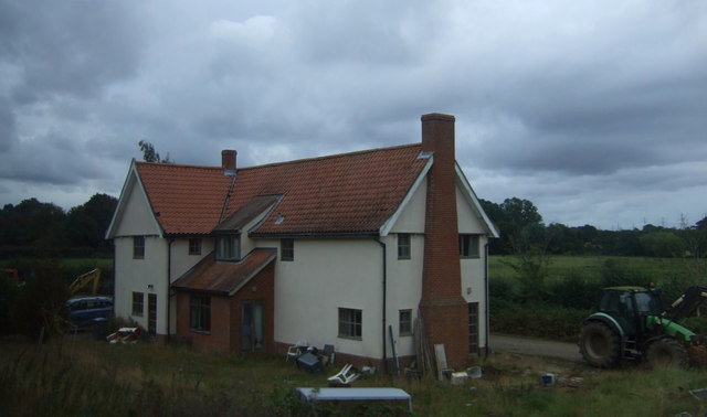
House, Botany Farm
House, Botany Farm
St Mary's Church The west tower is of brick with the lower stages faced in stone.  The huge buttresses (obscuring a small Norman window) were added in the 18th century to counter the outward lean of the south wall due to subsidence on the hilltop site, the dramatic effect of which can be seen inside the church.
St Mary's Church
The west tower is of brick with the lower stages faced in stone. The huge buttresses (obscuring a small Norman window) were added in the 18th century to counter the outward lean of the south wall due to subsidence on the hilltop site, the dramatic effect of which can be seen inside the church.
Fragment of a rood screen Two panels of tracery from the upper part of the medieval screen are displayed on the wall of St Mary's Church.
Fragment of a rood screen
Two panels of tracery from the upper part of the medieval screen are displayed on the wall of St Mary's Church.
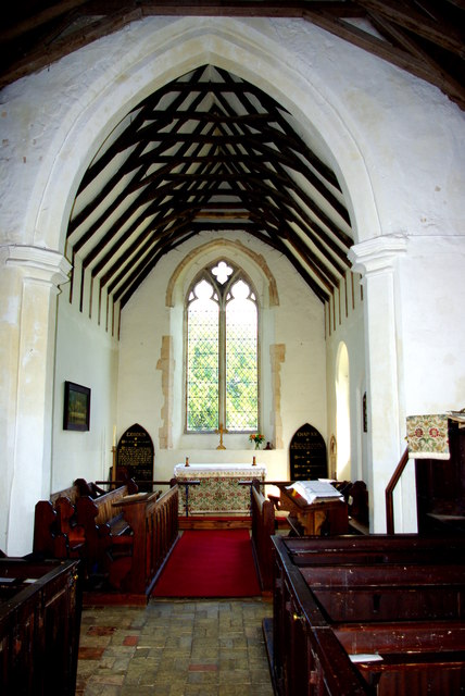
Inside St Mary's Church Looking west down the nave, the tremendous outward lean of the south wall is obvious.  The central window is Norman and is matched by a similar one on the north side.  Between the windows huge external buttresses counteract the outward thrust of the walls.  The roof has a scissor truss construction and the Georgian box pews are richly varnished.
Inside St Mary's Church
Looking west down the nave, the tremendous outward lean of the south wall is obvious. The central window is Norman and is matched by a similar one on the north side. Between the windows huge external buttresses counteract the outward thrust of the walls. The roof has a scissor truss construction and the Georgian box pews are richly varnished.
Chancel of St Mary's Church Pevsner, visiting in 1961, commented that this end of the church "seems all renewed".  The roof trusses echo those of the nave on a smaller scale.  The altar is flanked by Victorian decalogue boards.
Chancel of St Mary's Church
Pevsner, visiting in 1961, commented that this end of the church "seems all renewed". The roof trusses echo those of the nave on a smaller scale. The altar is flanked by Victorian decalogue boards.
Dead tree in Glemham Hall Grounds Seen from the car park of the FolkEast festival 2016
Dead tree in Glemham Hall Grounds
Seen from the car park of the FolkEast festival 2016
Flush Bracket OSBM G1530 Stratford St Andrew Long Row Flush Bracket OSBM G1530 Stratford St Andrew Long Row, NW face.
Flush Bracket OSBM G1530 Stratford St Andrew Long Row
Flush Bracket OSBM G1530 Stratford St Andrew Long Row, NW face.
Houses on the A12, Stratford St Andrew
Parkgate Farm from the A12
Mill Lane at the A12 end
Field by Mill Lane
Field by Mill Lane
Late afternoon clouds from Mill Lane
St Mary's church noticeboard, Farnham
View across fields from St Mary's churchyard, Farnham Looking towards the River Alde
View across fields from St Mary's churchyard, Farnham
Looking towards the River Alde
St Mary's churchyard looking south
Valley of the River Alde, from the railway The patches of woodland are Whin Covert (left) and Burnter's Covert (right).
Valley of the River Alde, from the railway
The patches of woodland are Whin Covert (left) and Burnter's Covert (right).
Show me another place!

Foxburrow Wood is located at Grid Ref: TM3659 (Lat: 52.185783, Lng: 1.4653325)

Administrative County: Suffolk

District: East Suffolk

Police Authority: Suffolk

What 3 Words

///variation.triads.sway. Near Saxmundham, Suffolk

Related Wikis

Farnham Manor

Farnham Manor is a grade II listed house in Farnham, Suffolk, England. It is timber-framed and dates from at least 1602 based on a year marked on plasterwork...

Farnham, Suffolk

Farnham is a village and civil parish about 3 miles (4.8 km) south-west of Saxmundham in the English county of Suffolk on the A12 road. Farnham is located...

Benhall Street

Benhall Street is a village in Suffolk, England.

Gromford

Gromford is a small village in Suffolk, England, just north of Snape along the Gromford Lane. == Notable persons == Birthplace of Ipswich Town footballer...

Nearby Amenities

Located within 500m of 52.185783,1.4653325
Molletts Farm B&B
Addr Postcode: IP17 1JY
Tourism: guest_house
Url: http://molletts.com/
Lat/Long: 52.189598/1.4617069
The data included in this document is from www.openstreetmap.org. The data is made available under ODbL.

Have you been to Foxburrow Wood?

Leave your review of Foxburrow Wood below (or comments, questions and feedback).