Broadmeadow Covert

Wood, Forest in Suffolk East Suffolk

England

Broadmeadow Covert

Fields, Barns and Woods A view at Carlton Green Farm.
Fields, Barns and Woods Credit: Des Blenkinsopp

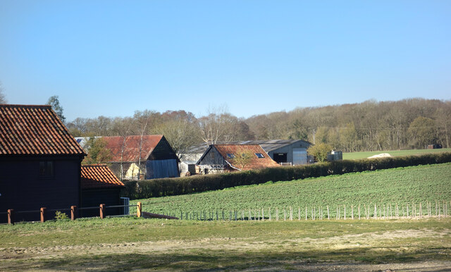
Broadmeadow Covert is a picturesque woodland located in Suffolk, England. This enchanting forest covers an area of approximately 50 acres and is known for its diverse range of flora and fauna. The covert is situated near the village of Broadmeadow, which is nestled within the Suffolk countryside.

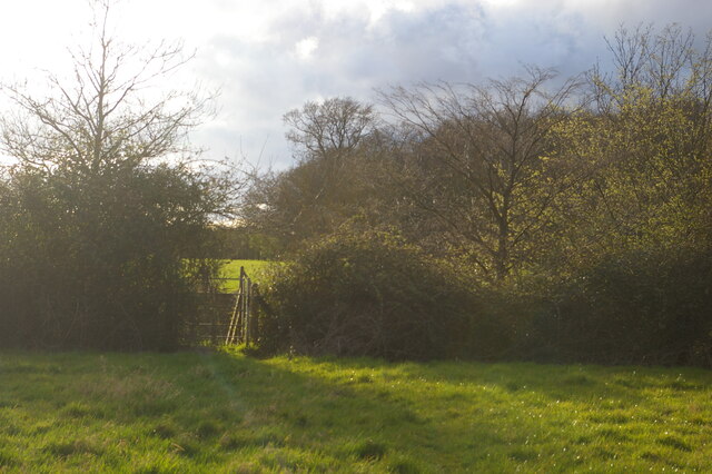
As one steps into Broadmeadow Covert, they are immediately greeted by a canopy of towering trees that provide a sense of tranquility and seclusion. The woodland is predominantly composed of native species such as oak, beech, and birch trees, which create a dense and lush environment. These trees offer shelter and support for a variety of wildlife, making the covert a haven for nature enthusiasts and birdwatchers.

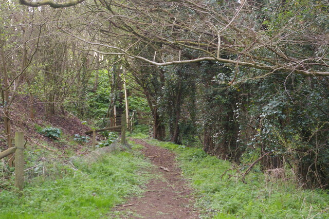
Within the covert, visitors can explore a network of winding paths, allowing them to fully immerse themselves in the natural beauty of the surroundings. The forest floor is covered in a vibrant carpet of wildflowers and moss, adding a burst of color to the green landscape. It is not uncommon to spot small mammals like rabbits and squirrels darting among the undergrowth, while bird species such as woodpeckers and thrushes can be heard singing their melodious tunes from the treetops.

Broadmeadow Covert is a cherished local treasure, attracting visitors throughout the year. It offers a peaceful retreat for those seeking solace in nature and serves as an important habitat for wildlife conservation. The beauty and tranquility of this Suffolk woodland make it a must-visit destination for anyone looking to reconnect with the natural world.

If you have any feedback on the listing, please let us know in the comments section below.

Broadmeadow Covert Images

Images are sourced within 2km of 52.22436/1.4518321 or Grid Reference TM3564. Thanks to Geograph Open Source API. All images are credited.

Fields, Barns and Woods A view at Carlton Green Farm.
Fields, Barns and Woods
A view at Carlton Green Farm.
Farmland and Two Heaps Fields at Carlton Green.
Farmland and Two Heaps
Fields at Carlton Green.
Cyclists Dismount A few metres of cycleway making a straight crossing for bikes over the A12 avoiding the slightly staggered crossing for other vehicles.
Cyclists Dismount
A few metres of cycleway making a straight crossing for bikes over the A12 avoiding the slightly staggered crossing for other vehicles.
Footpath running west from Ash Ground, Saxmundham The A12 runs in a cutting beyond the hedge: the gate on the far side of the road can just be made out through the gate in the near hedge.
Footpath running west from Ash Ground, Saxmundham
The A12 runs in a cutting beyond the hedge: the gate on the far side of the road can just be made out through the gate in the near hedge.
Footpath towards the A12, Saxmundham The footpath climbs up the steps seen here and emerges on the verge of the A12, here crossing the valley of a small brook on an embankment.
Footpath towards the A12, Saxmundham
The footpath climbs up the steps seen here and emerges on the verge of the A12, here crossing the valley of a small brook on an embankment.
Track from the B1119 towards Sweffling Hall
Church of St. Michael, Rendham <span class="nowrap"><a title="https://historicengland.org.uk/listing/the-list/list-entry/1199503?section=official-list-entry" rel="nofollow ugc noopener" href="https://historicengland.org.uk/listing/the-list/list-entry/1199503?section=official-list-entry">Link</a><img style="margin-left:2px;" alt="External link" title="External link - shift click to open in new window" src="https://s1.geograph.org.uk/img/external.png" width="10" height="10"/></span>
Church of St. Michael, Rendham
Church of St Mary, Sweffling <span class="nowrap"><a title="https://historicengland.org.uk/listing/the-list/list-entry/1030766?section=official-list-entry" rel="nofollow ugc noopener" href="https://historicengland.org.uk/listing/the-list/list-entry/1030766?section=official-list-entry">Link</a><img style="margin-left:2px;" alt="External link" title="External link - shift click to open in new window" src="https://s1.geograph.org.uk/img/external.png" width="10" height="10"/></span>
Church of St Mary, Sweffling
Rendham Road The B1119 looking in the direction of Rendham.
Rendham Road
The B1119 looking in the direction of Rendham.
The Rendham White Horse Not to be confused with the Sweffling White Horse which is half a kilometre or so away.
The Rendham White Horse
Not to be confused with the Sweffling White Horse which is half a kilometre or so away.
The Gull, Sweffling The Gull is the stream which runs alongside the road which runs between the main part of the village and The White Horse to the north.
The Gull, Sweffling
The Gull is the stream which runs alongside the road which runs between the main part of the village and The White Horse to the north.
Roadsigns on Carlton Road At the junction with the A12 Saxmundham Bypass
Roadsigns on Carlton Road
At the junction with the A12 Saxmundham Bypass
Roadsign on the A12 Saxmundham Bypass At the junction with Carlton Road
Roadsign on the A12 Saxmundham Bypass
At the junction with Carlton Road
Carlton Road sign On Carlton Road at the junction with the A12 Saxmundham Bypass
Carlton Road sign
On Carlton Road at the junction with the A12 Saxmundham Bypass
St Mary, Sweffling Mostly C15 but the nave is C12.
St Mary, Sweffling
Mostly C15 but the nave is C12.
Sweffling
Sweffling
Rendham village hall
St Michael's church, Rendham Some parts of the church are C15 but it was extensively restored in 1852.
St Michael's church, Rendham
Some parts of the church are C15 but it was extensively restored in 1852.
Show me another place!

Broadmeadow Covert is located at Grid Ref: TM3564 (Lat: 52.22436, Lng: 1.4518321)

Administrative County: Suffolk

District: East Suffolk

Police Authority: Suffolk

What 3 Words

///lizards.jots.flown. Near Saxmundham, Suffolk

Nearby Locations

Broadmeadow Covert

Related Wikis

Rendham

Rendham is a village and civil parish on the B1119 road, in the East Suffolk district, in the English county of Suffolk. It is near the town Saxmundham...

Sweffling

Sweffling is a village and a civil parish in the East Suffolk district, in the county of Suffolk, England. Nearby settlements include the town of Saxmundham...

Skoulding's Mill

Skoulding's Mill is a Grade II listed tower mill at Kelsale, Suffolk, England which has been converted to residential accommodation. == History == Skoulding...

SET Saxmundham School

SET Saxmundham School (formerly Saxmundham Free School) is a free school in Saxmundham, Suffolk, East Anglia, with approximately 222 pupils. It opened...

Have you been to Broadmeadow Covert?

Leave your review of Broadmeadow Covert below (or comments, questions and feedback).