Fromefield

Settlement in Somerset Mendip

England

Fromefield

Old Milestone Plate, Frome Museum The plate was originally attached to the milestone that was located on Marston Road, Frome, at the roundabout junction with the A381 (ST 77817 48242). Old Bruton iron plate design, milestone erected by the Bruton turnpike trust in the 19th century.

Inscription reads:-
TO
BRUTON
9

Milestone Society National ID: SO_BNFR09
Old Milestone Plate, Frome Museum Credit: Janet Dowding

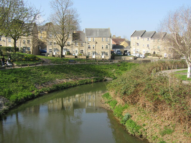
Fromefield is a small village located in the county of Somerset, England. Situated approximately 15 miles south of Bath, it offers a picturesque countryside setting with lush green fields and rolling hills. The village is part of the larger town of Frome, but has its own distinct character and charm.

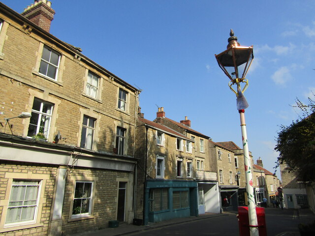
Fromefield is home to a close-knit community, with a population of just over 1,000 residents. The village exudes a peaceful and tranquil atmosphere, making it an ideal place for those seeking a quieter lifestyle. It boasts a range of period cottages and traditional stone houses, adding to its rural charm.

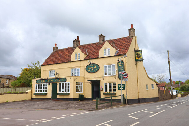
Although small in size, Fromefield has a few amenities to serve its residents. There is a local village shop that caters to daily needs, and a cozy pub where locals gather for a drink and a chat. For a wider range of facilities, the nearby town of Frome offers a variety of shops, supermarkets, restaurants, and leisure activities.

Nature enthusiasts will appreciate the surrounding landscape, as the village is nestled in the heart of the Somerset countryside. There are plenty of scenic walking and cycling routes to explore, providing opportunities to enjoy the beauty of the area. Fromefield also benefits from its proximity to the Mendip Hills, a designated Area of Outstanding Natural Beauty, which offers stunning views and outdoor recreational opportunities.

Overall, Fromefield is a charming village that offers a tranquil and idyllic setting for residents seeking a peaceful countryside lifestyle. With its beautiful surroundings and close community, it is a place that embraces the beauty of rural England.

If you have any feedback on the listing, please let us know in the comments section below.

Fromefield Images

Images are sourced within 2km of 51.237009/-2.312522 or Grid Reference ST7848. Thanks to Geograph Open Source API. All images are credited.

Old Milestone Plate, Frome Museum The plate was originally attached to the milestone that was located on Marston Road, Frome, at the roundabout junction with the A381 (ST 77817 48242). Old Bruton iron plate design, milestone erected by the Bruton turnpike trust in the 19th century.

Inscription reads:-
TO
BRUTON
9

Milestone Society National ID: SO_BNFR09
Old Milestone Plate, Frome Museum
The plate was originally attached to the milestone that was located on Marston Road, Frome, at the roundabout junction with the A381 (ST 77817 48242). Old Bruton iron plate design, milestone erected by the Bruton turnpike trust in the 19th century. Inscription reads:- TO BRUTON 9 Milestone Society National ID: SO_BNFR09
Old Milestone Plate, Frome Museum The milestone to which the metal plate was originally attached could have been located at <a href="https://www.geograph.org.uk/gridref/ST647598">ST647598</a> on the A390 or at <a href="https://www.geograph.org.uk/gridref/ST6805854506">ST6805854506</a> on the A367. Old Bruton iron plate design, milestone erected by the Bruton turnpike trust in the 19th century. 

Inscription reads:- 
TO / BATH / 9 

Milestone Society National ID: SO_BA09
Old Milestone Plate, Frome Museum
The milestone to which the metal plate was originally attached could have been located at ST647598 on the A390 or at ST6805854506 on the A367. Old Bruton iron plate design, milestone erected by the Bruton turnpike trust in the 19th century. Inscription reads:- TO / BATH / 9 Milestone Society National ID: SO_BA09
Old Milestone, B3090, Fromefield, Frome The milestone is located opposite Brunswick Place, set into a stone wall on the west side of the road. Parish of Frome (Mendip District). Cast iron post, C&M Classical iron casting design, erected by the Black Dog turnpike trust in the 19th century. 

Inscription reads:-
BATH / 13 / FROME / MARKET HOUSE / ½ MILE / FROME

Grade II Listed, List Entry Number: 1296373
<span class="nowrap"><a title="https://historicengland.org.uk/listing/the-list/list-entry/1296373" rel="nofollow ugc noopener" href="https://historicengland.org.uk/listing/the-list/list-entry/1296373">Link</a><img style="margin-left:2px;" alt="External link" title="External link - shift click to open in new window" src="https://s1.geograph.org.uk/img/external.png" width="10" height="10"/></span>

Milestone Society National ID: SO_BAFR13
Old Milestone, B3090, Fromefield, Frome
The milestone is located opposite Brunswick Place, set into a stone wall on the west side of the road. Parish of Frome (Mendip District). Cast iron post, C&M Classical iron casting design, erected by the Black Dog turnpike trust in the 19th century. Inscription reads:- BATH / 13 / FROME / MARKET HOUSE / ½ MILE / FROME Grade II Listed, List Entry Number: 1296373 LinkExternal link Milestone Society National ID: SO_BAFR13
The Blue Boar Public House in Frome.
The Blue Boar
Public House in Frome.
The Royal Oak Public House in Frome.
The Royal Oak
Public House in Frome.
Frome Flea Market at the Cheese and Grain Takes place on Wednesdays, 9 am till 2 pm.
Frome Flea Market at the Cheese and Grain
Takes place on Wednesdays, 9 am till 2 pm.
Frome - The Blue House Historic building, former almshouses, then a Bluecoat School, now retirement flats.
Frome - The Blue House
Historic building, former almshouses, then a Bluecoat School, now retirement flats.
Frome - River Frome View from the bridge towards modern housing overlooking the river.
Frome - River Frome
View from the bridge towards modern housing overlooking the river.
Frome - George Hotel Old hostelry and the Market Cross in central Frome.
Frome - George Hotel
Old hostelry and the Market Cross in central Frome.
Frome - Parish Church St John the Baptist, an historic and venerable church in central Frome.
Frome - Parish Church
St John the Baptist, an historic and venerable church in central Frome.
Frome - Font 13th century font within St John the Baptist Church. Note also the historic font cover.
Frome - Font
13th century font within St John the Baptist Church. Note also the historic font cover.
Frome - St John the Baptist Church High cross - an interior view within Frome's historic parish church.
Frome - St John the Baptist Church
High cross - an interior view within Frome's historic parish church.
Frome - Bath Street Main street in central Frome, heading downhill from the parish church towards the Market Place.
Frome - Bath Street
Main street in central Frome, heading downhill from the parish church towards the Market Place.
Frome - Palmer Street Historic lane with many independent shops in central Frome.
Frome - Palmer Street
Historic lane with many independent shops in central Frome.
Frome - Catherine Street Historic narrow town centre street with many old stone buildings.
Frome - Catherine Street
Historic narrow town centre street with many old stone buildings.
Frome - Catherine by Gaslight Catherine Street and historic gas lamp (The Valentine Lamp) in central Frome.
Frome - Catherine by Gaslight
Catherine Street and historic gas lamp (The Valentine Lamp) in central Frome.
Frome - The Valentine Lamp Historic gas lamp on Catherine Street - note the small heart.
Frome - The Valentine Lamp
Historic gas lamp on Catherine Street - note the small heart.
Gentle Street, Frome
Show me another place!

Fromefield is located at Grid Ref: ST7848 (Lat: 51.237009, Lng: -2.312522)

Administrative County: Somerset

District: Mendip

Police Authority: Avon and Somerset

What 3 Words

///candle.range.march. Near Frome, Somerset

Nearby Locations

Fromefield

Related Wikis

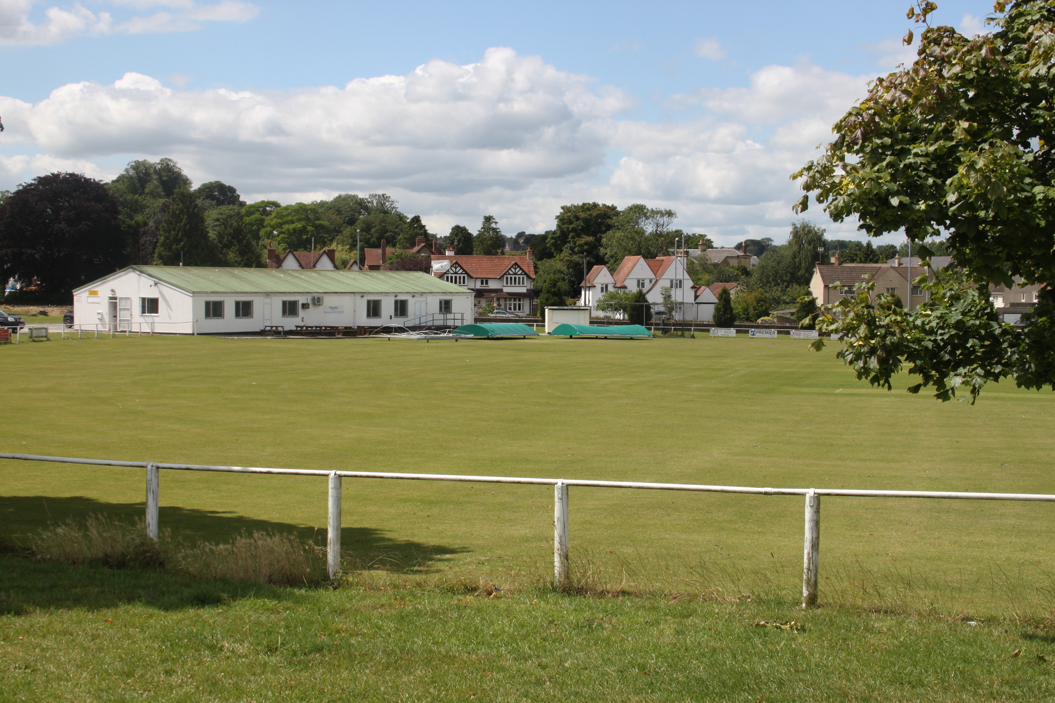
Agricultural Showgrounds, Frome

Agricultural Showgrounds is a cricket ground in Frome, Somerset, England. The first recorded match on the ground was in 1882, when Frome played United...

North Hill House School

North Hill House School, also referred to as NHH, is an independent specialist school in Frome, Somerset, England for children and young people with Autism...

Frome Town F.C.

Frome Town Football Club is an English football club based in Frome, a town in the county of Somerset. They play in the Southern League Division One South...

Selwood, Somerset

Selwood used to be a village but is now part of the suburbs of Frome. It is a civil parish in the Mendip district of Somerset, England. The parish includes...

St Mary's Church, Frome

St Mary's Church is a Church of England parish church in Frome, Somerset, England. It was built in 1862–1864 to the designs of C. E. Giles and is a Grade...

Frome Heritage Museum

Frome Heritage Museum in Frome, Somerset, England houses a collection of local history and has a particularly important collection of artefacts from the...

Frome Community College

Frome Community College, styled as Frome College, is a comprehensive school in Frome, Somerset, England for students aged 13 to 18. Approximately 1,200...

Blue House, Frome

The Blue House in Frome, Somerset, England, was built in 1726 and has been designated as a Grade I listed building.The Blue House, located adjacent to...

Nearby Amenities

Located within 500m of 51.237009,-2.312522
Post Office
Rodden road Post Office
Lat/Long: 51.2348347/-2.3132998
Man Made: street_cabinet
Lat/Long: 51.2366264/-2.3196041
Post Box
Operator: Royal Mail
Operator Wikidata: Q638098
Post Box Type: pillar
Lat/Long: 51.2366903/-2.3196095
Turning Circle
Lat/Long: 51.2372476/-2.3186594
Barrier: bollard
Lat/Long: 51.2402881/-2.3123275
Fromefield
Place: suburb
Source: OS_OpenData_StreetView
Lat/Long: 51.2358901/-2.314651
Crossing
Lat/Long: 51.233513/-2.3131169
Crossing
Crossing: zebra
Lat/Long: 51.2369571/-2.3146715
Crossing
Crossing: unmarked
Crossing Island: yes
Crossing Markings: no
Source: aerial imagery
Tactile Paving: yes
Lat/Long: 51.2375745/-2.3138795
Traffic Signals
Traffic Signals Direction: backward
Lat/Long: 51.2351469/-2.3131827
Crossing
Crossing: traffic_signals
Crossing Ref: toucan
Lat/Long: 51.2362908/-2.3135576
Barrier: block
Bicycle: yes
Foot: yes
Lat/Long: 51.2368481/-2.3174322
Traffic Signals
Traffic Signals Direction: backward
Lat/Long: 51.2349009/-2.3130688
Mini Roundabout
Direction: clockwise
Lat/Long: 51.2403242/-2.311417
Crossing
Source: Bing
Lat/Long: 51.2374339/-2.3124396
Crossing
Source: Bing
Lat/Long: 51.2375445/-2.312726
Traffic Signals
Traffic Signals Direction: both
Lat/Long: 51.2402392/-2.3125956
Post Box
Brand: Royal Mail
Brand Wikidata: Q638098
Mapillary: 687783202929799
Operator: Royal Mail
Operator Wikidata: Q638098
Post Box Type: pillar
Survey Date: 2023-08-10
Lat/Long: 51.240667/-2.3127334
Barrier: block
Lat/Long: 51.2358626/-2.3113821
Barrier: block
Lat/Long: 51.235777/-2.311323
Bicycle Parking
Capacity: 20
Lat/Long: 51.2370776/-2.3120252
Barrier: bollard
Lat/Long: 51.2377233/-2.311459
Traffic Signals
Traffic Signals Direction: forward
Lat/Long: 51.235039/-2.3128647
Traffic Signals
Traffic Signals Direction: backward
Lat/Long: 51.2350325/-2.3133507
Communication Mobile Phone: yes
Height: 15
Man Made: mast
Operator: Vodafone
Operator Wikidata: Q122141
Tower Construction: monopole
Tower Type: communication
Lat/Long: 51.2364395/-2.3134376
Crossing
Crossing: zebra
Lat/Long: 51.2359756/-2.3061024
Veterinary
Frome Veterinary Centre
Addr City: Frome
Addr Housenumber: 39
Addr Postcode: BA11 2EH
Addr Street: Berkley Road
Operator: Highcroft Veterinary Group
Lat/Long: 51.2351918/-2.3118041
Spar
Branch: Rodden Road
Brand: Spar
Brand Wikidata: Q610492
Shop: convenience
Website: https://www.spar.co.uk/store-locator/awl28364-spar-rodden-road/
Wheelchair: yes
Lat/Long: 51.2348535/-2.3134215
Bus Stop
Grange Road
Bus: yes
Naptan AtcoCode: 3600SOB21732
Naptan Bearing: S
Naptan CommonName: Grange Road
Naptan Indicator: S-bound
Naptan NaptanCode: sotdmadt
Naptan Street: Bath Road
Naptan Verified: no
Public Transport: platform
Lat/Long: 51.2413916/-2.3122025
Bus Stop
Sports Centre
Bus: yes
Naptan AtcoCode: 3600SOB21809
Naptan Bearing: E
Naptan CommonName: Sports Centre
Naptan Indicator: E-bound
Naptan NaptanCode: sotdmaja
Naptan Street: Stonebridge Drive
Naptan Verified: no
Public Transport: platform
Lat/Long: 51.2403251/-2.3096691
Bus Stop
Selwood School
Bus: yes
Naptan AtcoCode: 3600SOB21824
Naptan Bearing: SW
Naptan CommonName: Selwood School
Naptan Indicator: SW-bound
Naptan NaptanCode: sotdmajp
Naptan Street: Berkley Road
Naptan Verified: no
Public Transport: platform
Lat/Long: 51.2358981/-2.306258
Bus Stop
Football Ground
Bus: yes
Naptan AtcoCode: 3600SOB21826
Naptan Bearing: W
Naptan CommonName: Football Ground
Naptan Indicator: W-bound
Naptan NaptanCode: sotdmajg
Naptan Street: Berkley Road
Naptan Verified: no
Public Transport: platform
Lat/Long: 51.2351897/-2.3090827
Bus Stop
Windsor Crescent
Bus: yes
Naptan AtcoCode: 3600SOB21828
Naptan Bearing: SW
Naptan CommonName: Windsor Crescent
Naptan Indicator: SW-bound
Naptan NaptanCode: sotdjwtm
Naptan Street: Berkley Road
Naptan Verified: no
Public Transport: platform
Lat/Long: 51.2345455/-2.3155235
Bus Stop
North Hill House
Bus: yes
Naptan AtcoCode: 3600SOB21726
Naptan Bearing: NE
Naptan CommonName: North Hill House
Naptan Indicator: NE-bound
Naptan NaptanCode: sotdjwpg
Naptan Street: Fromefield
Naptan Verified: no
Public Transport: platform
Lat/Long: 51.2338324/-2.3175155
Bus Stop
Windsor Crescent
Bus: yes
Naptan AtcoCode: 3600SOB21829
Naptan Bearing: NE
Naptan CommonName: Windsor Crescent
Naptan Indicator: NE-bound
Naptan NaptanCode: sotdjwtj
Naptan Street: Berkley Road
Naptan Verified: no
Public Transport: platform
Lat/Long: 51.2347922/-2.3149726
Bus Stop
Football Ground
Bus: yes
Naptan AtcoCode: 3600SOB21827
Naptan Bearing: E
Naptan CommonName: Football Ground
Naptan Indicator: E-bound
Naptan NaptanCode: sotdmajd
Naptan Street: Berkley Road
Naptan Verified: no
Public Transport: platform
Lat/Long: 51.2352491/-2.3089834
Bus Stop
Selwood School
Bus: yes
Naptan AtcoCode: 3600SOB21825
Naptan Bearing: NE
Naptan CommonName: Selwood School
Naptan Indicator: NE-bound
Naptan NaptanCode: sotdmajt
Naptan Street: Berkley Road
Naptan Verified: no
Public Transport: platform
Lat/Long: 51.236021/-2.3060611
Bus Stop
Sports Centre
Bus: yes
Naptan AtcoCode: 3600SOB21808
Naptan Bearing: W
Naptan CommonName: Sports Centre
Naptan Indicator: W-bound
Naptan NaptanCode: sotdmagp
Naptan Street: Stonebridge Drive
Naptan Verified: no
Public Transport: platform
Lat/Long: 51.2401631/-2.3108939
Bus Stop
Grange Road
Bus: yes
Naptan AtcoCode: 3600SOB21731
Naptan Bearing: N
Naptan CommonName: Grange Road
Naptan Indicator: N-bound
Naptan NaptanCode: sotdmadp
Naptan Street: Bath Road
Naptan Verified: no
Public Transport: platform
Lat/Long: 51.2412061/-2.312359
Bus Stop
Northstead
Bus: yes
Naptan AtcoCode: 3600SOB21728
Naptan Bearing: NE
Naptan CommonName: Northstead
Naptan Indicator: NE-bound
Naptan NaptanCode: sotdjwtd
Naptan Street: Fromefield
Naptan Verified: no
Public Transport: platform
Lat/Long: 51.2351696/-2.3158467
Bus Stop
Hospital
Bus: yes
Naptan AtcoCode: 3600SOA04179
Naptan Bearing: SE
Naptan CommonName: Hospital
Naptan Indicator: o/s
Naptan NaptanCode: sotdtdjp
Naptan Verified: no
Public Transport: platform
Lat/Long: 51.237975/-2.3119211
Bus Stop
Spring Road
Bus: yes
Naptan AtcoCode: 3600SOB21729
Naptan Bearing: NE
Naptan CommonName: Spring Road
Naptan Indicator: NE-bound
Naptan NaptanCode: sotdmadm
Naptan Street: Bath Road
Naptan Verified: no
Public Transport: platform
Lat/Long: 51.237561/-2.3141092
Bus Stop
Rodden Road
Bus: yes
Naptan AtcoCode: 3600SOB21730
Naptan Bearing: S
Naptan CommonName: Rodden Road
Naptan Indicator: S-bound
Naptan NaptanCode: sotdmadg
Naptan Street: Fromefield
Naptan Verified: no
Public Transport: platform
Lat/Long: 51.2372893/-2.3142886
Bus Stop
Beechwood Avenue
Bus: yes
Naptan AtcoCode: 3600SOA56838
Naptan Bearing: S
Naptan CommonName: Beechwood Avenue
Naptan Indicator: S-bound
Naptan NaptanCode: sotdpmgj
Naptan Street: Rodden Road
Naptan Verified: no
Public Transport: platform
Lat/Long: 51.2337686/-2.3124413
Bus Stop
Hospital
Bus: yes
Naptan AtcoCode: 360000097
Naptan Bearing: S
Naptan CommonName: Hospital
Naptan Indicator: S-bound
Naptan NaptanCode: sotdtjwa
Naptan Verified: no
Public Transport: platform
Lat/Long: 51.2369859/-2.3135136
Post Box
Mapillary: 1173231753128974
Operator: Royal Mail
Operator Wikidata: Q638098
Post Box Mounting: stone_wall
Post Box Type: wall
Lat/Long: 51.2342918/-2.3161414
Mapillary: 817160836575523
Operator: Royal Mail
Operator Wikidata: Q638098
Post Box Type: pillar
Removed Amenity: post_box
Royal Cypher: EIIR
Lat/Long: 51.2369704/-2.3145112
The data included in this document is from www.openstreetmap.org. The data is made available under ODbL.

Have you been to Fromefield?

Leave your review of Fromefield below (or comments, questions and feedback).