Church Wood

Wood, Forest in Kent Dover

England

Church Wood

North Downs Way beside a trig point on Shakespeare Cliff The long distance path leads along a cliff top path towards Dover.
North Downs Way beside a trig point on Shakespeare Cliff Credit: David Anstiss

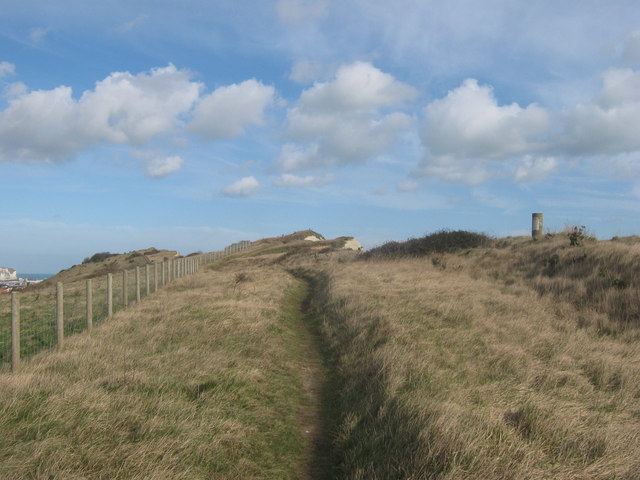
Church Wood is a picturesque woodland located in the county of Kent, England. Covering an area of approximately 100 acres, it is nestled in the heart of rural Kent, just a few miles from the village of Lamberhurst. This ancient woodland dates back hundreds of years and is home to a diverse range of flora and fauna.

The wood is primarily composed of broadleaf trees, including oak, beech, and ash, which create a dense canopy that provides shade and shelter for the woodland floor. During spring, the forest comes alive with a carpet of bluebells, creating a stunning display of color.

Church Wood is renowned for its tranquil atmosphere and is a popular destination for nature enthusiasts, walkers, and photographers. The woodland offers a network of well-maintained footpaths and trails, allowing visitors to explore its beauty at their own pace. Along the paths, one can find various species of birds, such as woodpeckers, robins, and owls, as well as small mammals like squirrels and rabbits.

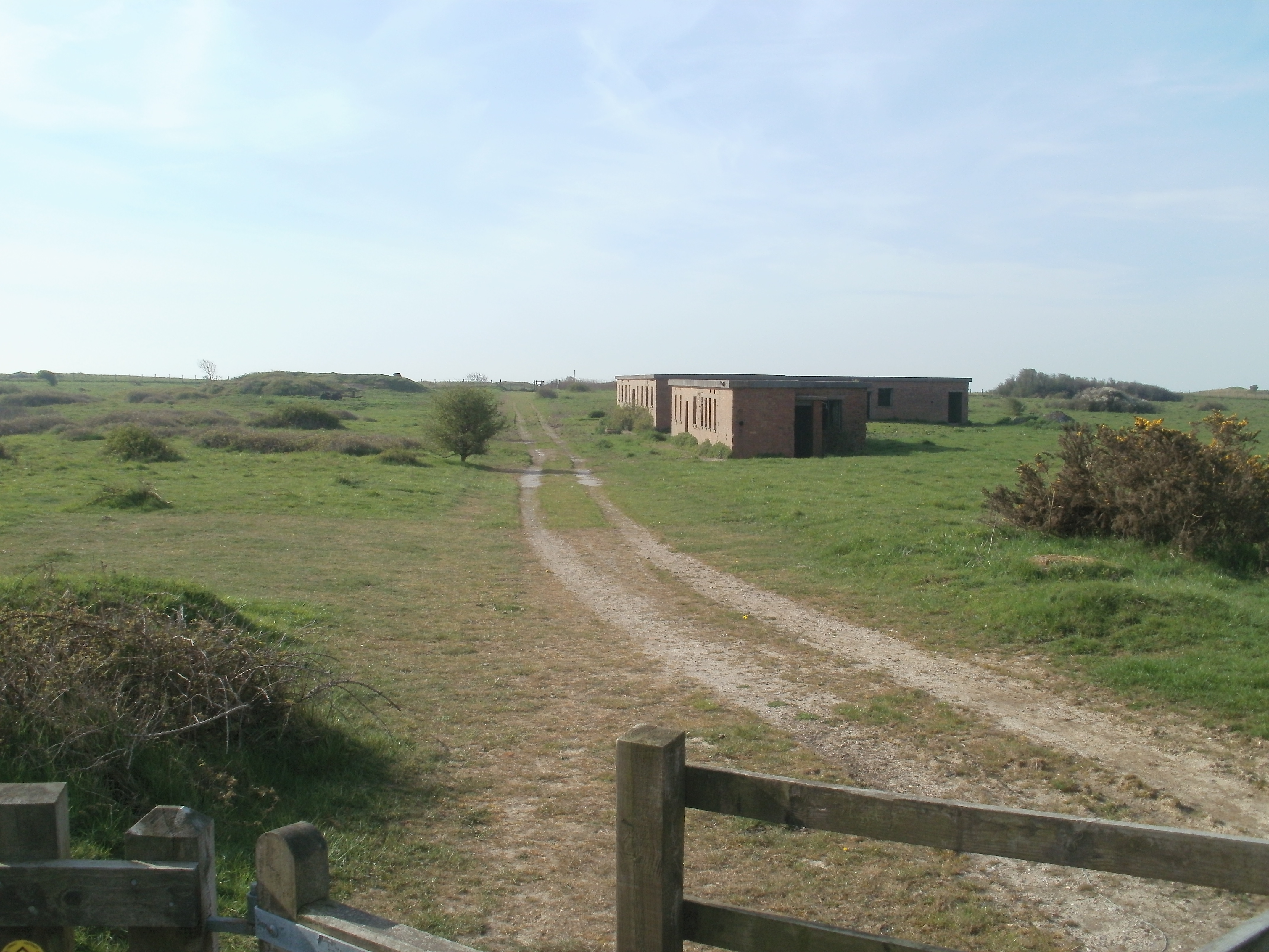
The wood is also home to several historic features, including the ruins of an ancient church that dates back to the 13th century. These remnants provide a glimpse into the area's rich history and add an air of intrigue to the woodland.

Church Wood offers a peaceful retreat from the hustle and bustle of everyday life, providing visitors with an opportunity to connect with nature and enjoy the beauty of the Kent countryside. With its stunning scenery, diverse wildlife, and historical significance, it is no wonder that Church Wood is a beloved destination for nature lovers and history enthusiasts alike.

If you have any feedback on the listing, please let us know in the comments section below.

Church Wood Images

Images are sourced within 2km of 51.107814/1.2566776 or Grid Reference TR2839. Thanks to Geograph Open Source API. All images are credited.

North Downs Way beside a trig point on Shakespeare Cliff The long distance path leads along a cliff top path towards Dover.
North Downs Way beside a trig point on Shakespeare Cliff
The long distance path leads along a cliff top path towards Dover.
Trig Point - Shakespeare Cliff
Air Conditioning building
Track up Long Hill
Track up Long Hill
Dover Transmitting Station The Dover transmitting station is a facility for broadcasting and telecommunications, located at West Hougham, near Dover. It has a 243.2 metres (798 ft) high guyed steel lattice mast.
Wikipedia: <span class="nowrap"><a title="https://en.wikipedia.org/wiki/Dover_transmitting_station" rel="nofollow ugc noopener" href="https://en.wikipedia.org/wiki/Dover_transmitting_station">Link</a><img style="margin-left:2px;" alt="External link" title="External link - shift click to open in new window" src="https://s1.geograph.org.uk/img/external.png" width="10" height="10"/></span>
Dover Transmitting Station
The Dover transmitting station is a facility for broadcasting and telecommunications, located at West Hougham, near Dover. It has a 243.2 metres (798 ft) high guyed steel lattice mast. Wikipedia: LinkExternal link
Victorian postbox In the British Isles the first pillar post boxes were erected in Jersey in 1852. Roadside wall boxes first appeared in 1857 as a cheaper alternative to pillar boxes, especially in rural districts. In 1853 the first pillar box in Britain was installed at Botchergate, Carlisle. In 1856 Richard Redgrave of the Department of Science and Art designed an ornate pillar box for use in London and other large cities. In 1859 the design was improved, and this became the first National Standard pillar box. Green was adopted as the standard colour for the early Victorian post boxes. Between 1866 and 1879 the hexagonal Penfold post box became the standard design for pillar boxes and it was during this period that red was first adopted as the standard colour. The first boxes to be painted red were in London in July 1874, although it would be nearly 10 years before all the boxes had been repainted.
Victorian postbox
In the British Isles the first pillar post boxes were erected in Jersey in 1852. Roadside wall boxes first appeared in 1857 as a cheaper alternative to pillar boxes, especially in rural districts. In 1853 the first pillar box in Britain was installed at Botchergate, Carlisle. In 1856 Richard Redgrave of the Department of Science and Art designed an ornate pillar box for use in London and other large cities. In 1859 the design was improved, and this became the first National Standard pillar box. Green was adopted as the standard colour for the early Victorian post boxes. Between 1866 and 1879 the hexagonal Penfold post box became the standard design for pillar boxes and it was during this period that red was first adopted as the standard colour. The first boxes to be painted red were in London in July 1874, although it would be nearly 10 years before all the boxes had been repainted.
Church Farmhouse
Church Farmhouse
War Memorial, Church of St Lawrence Grade II listed.
War Memorial, Church of St Lawrence
Grade II listed.
Church of St Lawrence and war memorial Grade I listed. <span class="nowrap"><a title="https://historicengland.org.uk/listing/the-list/list-entry/1070024" rel="nofollow ugc noopener" href="https://historicengland.org.uk/listing/the-list/list-entry/1070024">Link</a><img style="margin-left:2px;" alt="External link" title="External link - shift click to open in new window" src="https://s1.geograph.org.uk/img/external.png" width="10" height="10"/></span> 
<span class="nowrap"><a title="https://www.kentchurches.info/church.asp?p=Hougham" rel="nofollow ugc noopener" href="https://www.kentchurches.info/church.asp?p=Hougham">Link</a><img style="margin-left:2px;" alt="External link" title="External link - shift click to open in new window" src="https://s1.geograph.org.uk/img/external.png" width="10" height="10"/></span>
Church of St Lawrence and war memorial
Grade I listed. LinkExternal link LinkExternal link
Church of St Lawrence Grade I listed. <span class="nowrap"><a title="https://historicengland.org.uk/listing/the-list/list-entry/1070024" rel="nofollow ugc noopener" href="https://historicengland.org.uk/listing/the-list/list-entry/1070024">Link</a><img style="margin-left:2px;" alt="External link" title="External link - shift click to open in new window" src="https://s1.geograph.org.uk/img/external.png" width="10" height="10"/></span> 
<span class="nowrap"><a title="https://www.kentchurches.info/church.asp?p=Hougham" rel="nofollow ugc noopener" href="https://www.kentchurches.info/church.asp?p=Hougham">Link</a><img style="margin-left:2px;" alt="External link" title="External link - shift click to open in new window" src="https://s1.geograph.org.uk/img/external.png" width="10" height="10"/></span>
Church of St Lawrence
Grade I listed. LinkExternal link LinkExternal link
Church of St Lawrence Grade I listed buildings and structures are of exceptional, even international importance. There are over 6,000 in the country. Only 2.5% of listed buildings are Grade I listed.
In Scotland the classification is Category A
Index: <span class="nowrap"><a title="http://en.wikipedia.org/wiki/Category:Grade_I_listed_buildings" rel="nofollow ugc noopener" href="http://en.wikipedia.org/wiki/Category:Grade_I_listed_buildings">Link</a><img style="margin-left:2px;" alt="External link" title="External link - shift click to open in new window" src="https://s1.geograph.org.uk/img/external.png" width="10" height="10"/></span>
Church of St Lawrence
Grade I listed buildings and structures are of exceptional, even international importance. There are over 6,000 in the country. Only 2.5% of listed buildings are Grade I listed. In Scotland the classification is Category A Index: LinkExternal link
Dover Transmitting Station The Dover transmitting station is a facility for broadcasting and telecommunications, located at West Hougham, near Dover. It has a 243.2 metres (798 ft) high guyed steel lattice mast.
Wikipedia: <span class="nowrap"><a title="https://en.wikipedia.org/wiki/Dover_transmitting_station" rel="nofollow ugc noopener" href="https://en.wikipedia.org/wiki/Dover_transmitting_station">Link</a><img style="margin-left:2px;" alt="External link" title="External link - shift click to open in new window" src="https://s1.geograph.org.uk/img/external.png" width="10" height="10"/></span>
Dover Transmitting Station
The Dover transmitting station is a facility for broadcasting and telecommunications, located at West Hougham, near Dover. It has a 243.2 metres (798 ft) high guyed steel lattice mast. Wikipedia: LinkExternal link
Church of St Lawrence Grade I listed. <span class="nowrap"><a title="https://historicengland.org.uk/listing/the-list/list-entry/1070024" rel="nofollow ugc noopener" href="https://historicengland.org.uk/listing/the-list/list-entry/1070024">Link</a><img style="margin-left:2px;" alt="External link" title="External link - shift click to open in new window" src="https://s1.geograph.org.uk/img/external.png" width="10" height="10"/></span> 
<span class="nowrap"><a title="https://www.kentchurches.info/church.asp?p=Hougham" rel="nofollow ugc noopener" href="https://www.kentchurches.info/church.asp?p=Hougham">Link</a><img style="margin-left:2px;" alt="External link" title="External link - shift click to open in new window" src="https://s1.geograph.org.uk/img/external.png" width="10" height="10"/></span>
Church of St Lawrence
Grade I listed. LinkExternal link LinkExternal link
Dover Transmitting Station The Dover transmitting station is a facility for broadcasting and telecommunications, located at West Hougham, near Dover. It has a 243.2 metres (798 ft) high guyed steel lattice mast.
Wikipedia: <span class="nowrap"><a title="https://en.wikipedia.org/wiki/Dover_transmitting_station" rel="nofollow ugc noopener" href="https://en.wikipedia.org/wiki/Dover_transmitting_station">Link</a><img style="margin-left:2px;" alt="External link" title="External link - shift click to open in new window" src="https://s1.geograph.org.uk/img/external.png" width="10" height="10"/></span>
Dover Transmitting Station
The Dover transmitting station is a facility for broadcasting and telecommunications, located at West Hougham, near Dover. It has a 243.2 metres (798 ft) high guyed steel lattice mast. Wikipedia: LinkExternal link
Show me another place!

Church Wood is located at Grid Ref: TR2839 (Lat: 51.107814, Lng: 1.2566776)

Administrative County: Kent

District: Dover

Police Authority: Kent

What 3 Words

///ends.amending.nuggets. Near Capel le Ferne, Kent

Nearby Locations

Church Wood

Related Wikis

Lydden Spout Battery

Lydden Spout Battery is a World War II coastal defence battery built in 1941 west of Dover. Originally armed with three 6-inch Mark VII naval guns on Mark...

Dover transmitting station

The Dover transmitting station is a facility for broadcasting and telecommunications, located at West Hougham, near Dover, Kent (grid reference TR274397...

Hougham Battery

Hougham Battery is a World War II coastal defence battery built in 1941 between Dover and Folkestone in southeast England. It is on the cliff-edge between...

Samphire Hoe

Samphire Hoe is a country park situated 2 miles (3 km) west of Dover in Kent in southeast England. The park was created by using 4.9 million cubic metres...

Shakespeare Cliff Halt railway station

Shakespeare Cliff Halt is a private halt station on the South Eastern Main Line. It is located to the western end of the dual-bore Shakespeare Cliff tunnel...

Folkestone Warren

Folkestone Warren is a 316.3-hectare (782-acre) biological and geological Site of Special Scientific Interest (SSSI) which runs along the coast between...

Farthingloe

Farthingloe is a village west of Dover in southeast England. == External links == Media related to Farthingloe at Wikimedia Commons

RNAS Capel

RNAS Capel (later RAF Folkestone) was a First World War airship station near Folkestone, Kent. == History == When Germany declared in February 1915 that...

Nearby Amenities

Located within 500m of 51.107814,1.2566776
Barrier: stile
Lat/Long: 51.1073807/1.2576023
Barrier: stile
Lat/Long: 51.1084229/1.2608639
Barrier: stile
Lat/Long: 51.1089684/1.2622366
Barrier: stile
Lat/Long: 51.1067734/1.2632457
Barrier: kissing_gate
Lat/Long: 51.1067296/1.2632576
Barrier: stile
Lat/Long: 51.1074991/1.2629673
Barrier: stile
Lat/Long: 51.1060312/1.25773
Barrier: kissing_gate
Lat/Long: 51.1089538/1.2624152
Barrier: stile
Lat/Long: 51.1102084/1.2611406
Barrier: stile
Lat/Long: 51.1100623/1.2614143
Restaurant
The Plough
Addr City: Dover
Addr Postcode: CT15 7AB
Addr Street: Folkestone Road
Brand: Beefeater
Brand Wikidata: Q4879766
Cuisine: british
Fhrs Id: 254696
Food: yes
Operator: Beefeater
Source Addr: FHRS Open Data
Website: https://www.beefeater.co.uk/en-gb/locations/kent/the-plough
Lat/Long: 51.1110652/1.2599858
Bus Stop
The Plough
Bus: yes
Flag: no
Naptan AtcoCode: 240099200
Naptan Bearing: SW
Naptan BusStopType: CUS
Naptan CommonName: Plough Inn
Naptan Indicator: opp
Naptan Landmark: The Plough
Naptan NaptanCode: kntgmwpw
Naptan Street: Folkestone Road
Naptan Verified: no
Public Transport: platform
Source: naptan_import
Lat/Long: 51.1109412/1.2607255
Bus Stop
Hougham Court Lane
Bus: yes
Flag: no
Naptan AtcoCode: 240099202
Naptan Bearing: NE
Naptan BusStopType: CUS
Naptan CommonName: Hougham Court Lane
Naptan Indicator: adj
Naptan Landmark: Hougham Court Lane
Naptan NaptanCode: kntgmwpt
Naptan Street: Folkestone Road
Naptan Verified: no
Public Transport: platform
Source: naptan_import
Lat/Long: 51.1071336/1.2498406
Bus Stop
Hougham Court Lane
Bus: yes
Naptan AtcoCode: 2400A030510A
Naptan Bearing: SW
Naptan CommonName: Hougham Court Lane
Naptan Indicator: opp
Naptan Landmark: Hougham Court Lane
Naptan NaptanCode: kntdjapa
Naptan Street: Folkestone Road
Naptan Verified: no
Public Transport: platform
Source: naptan_import
Lat/Long: 51.1069634/1.2498144
Bus Stop
The Plough
Bus: yes
Naptan AtcoCode: 2400A030520A
Naptan Bearing: NE
Naptan CommonName: Plough Inn
Naptan Indicator: adj
Naptan Landmark: The Plough
Naptan NaptanCode: kntdjapd
Naptan Street: Folkestone Road
Naptan Verified: no
Public Transport: platform
Source: naptan_import
Lat/Long: 51.1111043/1.2606799
Premier Inn Dover (A20)
Brand: Premier Inn
Brand Wikidata: Q2108626
Source: website
Tourism: hotel
Lat/Long: 51.1108031/1.2593868
Barrier: kissing_gate
Lat/Long: 51.1040676/1.2592515
SVA Imports
Shop: car
Lat/Long: 51.1113439/1.260684
Barrier: kissing_gate
Lat/Long: 51.1043103/1.2609808
Artist Name: Rob Kesseler
Tourism: artwork
Lat/Long: 51.1047616/1.2556975
Bench
Backrest: no
Direction: SSE
Seats: 2
Lat/Long: 51.1047574/1.2557012
The data included in this document is from www.openstreetmap.org. The data is made available under ODbL.

Have you been to Church Wood?

Leave your review of Church Wood below (or comments, questions and feedback).