Hill Plantation

Wood, Forest in Norfolk Broadland

England

Hill Plantation

Hills and Hollows, Mousehold Heath A wooded area on the edge of Mousehold Heath which looks like it might have been quarries or claypits at one time.
Hills and Hollows, Mousehold Heath Credit: Des Blenkinsopp

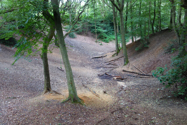
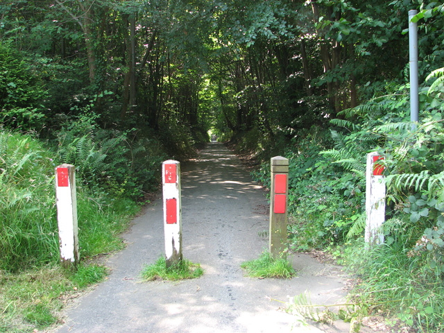
Hill Plantation, located in Norfolk, is a picturesque woodland area known for its natural beauty and serene atmosphere. Situated on a gently sloping hill, this plantation covers a vast expanse of land, encompassing dense forests and lush greenery. The plantation is a haven for a wide variety of flora and fauna, making it a popular destination for nature enthusiasts and wildlife lovers.

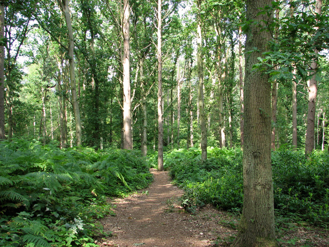
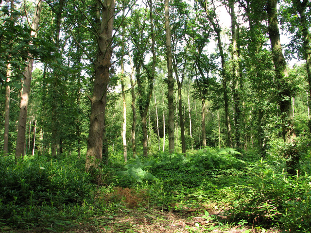
The woodlands of Hill Plantation are dominated by towering trees, including oak, beech, and pine, which create a dense canopy overhead. The forest floor is covered in a carpet of moss and ferns, adding to its enchanting appeal. The plantation is home to a diverse range of wildlife, including deer, foxes, rabbits, and numerous bird species. Birdwatchers can often spot woodpeckers, owls, and thrushes, among others.

Visitors to Hill Plantation can explore the many trails that wind through the woodlands, providing opportunities for hiking, walking, and cycling. The plantation also offers picnic areas and designated spots for nature observation, allowing visitors to fully immerse themselves in the tranquil surroundings.

Hill Plantation is not only a scenic retreat but also serves as an important conservation area. The local authorities have taken measures to preserve the natural ecosystem, ensuring the sustainability of the flora and fauna that thrive here.

Overall, Hill Plantation in Norfolk is a captivating destination for those seeking solace in nature. With its breathtaking landscapes, diverse wildlife, and recreational opportunities, it provides a truly immersive experience for all who venture into its enchanting woodlands.

If you have any feedback on the listing, please let us know in the comments section below.

Hill Plantation Images

Images are sourced within 2km of 52.650425/1.3303154 or Grid Reference TG2511. Thanks to Geograph Open Source API. All images are credited.

Hills and Hollows, Mousehold Heath A wooded area on the edge of Mousehold Heath which looks like it might have been quarries or claypits at one time.
Hills and Hollows, Mousehold Heath
A wooded area on the edge of Mousehold Heath which looks like it might have been quarries or claypits at one time.
Woodland, Mousehold Heath A surviving fragment of open space now surrounded by suburban Norwich.
"In Tudor times, Mousehold Heath stretched as far north as South Walsham and was 22 miles round. The surviving remnant of the heath was given to Norwich City Council (then known as the local corporation) to look after on behalf of the citizens of Norwich in 1880." quoted from <span class="nowrap"><a title="https://www.norwich.gov.uk/info/20006/sports_parks_and_leisure/1534/about_mousehold_heath" rel="nofollow ugc noopener" href="https://www.norwich.gov.uk/info/20006/sports_parks_and_leisure/1534/about_mousehold_heath">Link</a><img style="margin-left:2px;" alt="External link" title="External link - shift click to open in new window" src="https://s1.geograph.org.uk/img/external.png" width="10" height="10"/></span>
Woodland, Mousehold Heath
A surviving fragment of open space now surrounded by suburban Norwich. "In Tudor times, Mousehold Heath stretched as far north as South Walsham and was 22 miles round. The surviving remnant of the heath was given to Norwich City Council (then known as the local corporation) to look after on behalf of the citizens of Norwich in 1880." quoted from LinkExternal link
The Vinegar Pond, Mousehold Heath The pond gets its name from the occasional red algae bloom turning the water a vinegar like colour.  A long article about the pond and the heath is on <span class="nowrap"><a title="https://www.invisibleworks.co.uk/norwich-the-vinegar-pond/" rel="nofollow ugc noopener" href="https://www.invisibleworks.co.uk/norwich-the-vinegar-pond/">Link</a><img style="margin-left:2px;" alt="External link" title="External link - shift click to open in new window" src="https://s1.geograph.org.uk/img/external.png" width="10" height="10"/></span>
The Vinegar Pond, Mousehold Heath
The pond gets its name from the occasional red algae bloom turning the water a vinegar like colour. A long article about the pond and the heath is on LinkExternal link
Track on Mousehold Heath Mousehold Heath is an 88 hectare remnant of formerly extensive heathland which was given to Norwich City Council in 1880.
It is now surrounded by suburban development.
<span class="nowrap"><a title="https://www.norwich.gov.uk/info/20006/sports_parks_and_leisure/1534/about_mousehold_heath" rel="nofollow ugc noopener" href="https://www.norwich.gov.uk/info/20006/sports_parks_and_leisure/1534/about_mousehold_heath">Link</a><img style="margin-left:2px;" alt="External link" title="External link - shift click to open in new window" src="https://s1.geograph.org.uk/img/external.png" width="10" height="10"/></span>
Track on Mousehold Heath
Mousehold Heath is an 88 hectare remnant of formerly extensive heathland which was given to Norwich City Council in 1880. It is now surrounded by suburban development. LinkExternal link
Gurney Road through Mousehold Heath
Atlantic Avenue Part of an expansion of Norwich to the northeast.
Atlantic Avenue
Part of an expansion of Norwich to the northeast.
Works at Sprowston Retail Park
Offices, Sprowston Hidden away on an industrial estate is a novel-looking office block built for British Gas "utilizing the German Burolandschaft concept, whereby the first floor is open-plan while the ground floor has areas divided by low partitions." Built in 1970-71 to the designs of the Design Group for Industry.
Now known as Sapphire House. It's not clear to what extent the internal layout has survived.
Offices, Sprowston
Hidden away on an industrial estate is a novel-looking office block built for British Gas "utilizing the German Burolandschaft concept, whereby the first floor is open-plan while the ground floor has areas divided by low partitions." Built in 1970-71 to the designs of the Design Group for Industry. Now known as Sapphire House. It's not clear to what extent the internal layout has survived.
Police station, Sprowston On Wroxham Road. A period piece, 1950s neo-Georgian.
This may no longer be operational as police forces increasingly centralise facilities in order to keep costs down.
Police station, Sprowston
On Wroxham Road. A period piece, 1950s neo-Georgian. This may no longer be operational as police forces increasingly centralise facilities in order to keep costs down.
Belmore Plantation as seen from Pound Lane, Thorpe St Andrew Belmore Plantation is one of three woodlands (Racecourse, Belmore and Brown’s Plantations) in Thorpe St Andrew, just outside Norwich. Their total area is 205 acres (82 hectares), and together they form the largest area of woodland within several miles of Norwich. The woodlands are owned by the Thorpe & Felthorpe Trust, the Trustees of which are five members of the Gurney family. Local residents are opposing a developer's plan to build 631 housing 'units' here.
Belmore Plantation as seen from Pound Lane, Thorpe St Andrew
Belmore Plantation is one of three woodlands (Racecourse, Belmore and Brown’s Plantations) in Thorpe St Andrew, just outside Norwich. Their total area is 205 acres (82 hectares), and together they form the largest area of woodland within several miles of Norwich. The woodlands are owned by the Thorpe & Felthorpe Trust, the Trustees of which are five members of the Gurney family. Local residents are opposing a developer's plan to build 631 housing 'units' here.
Redwood tree on the edge of Belmore Plantation, Thorpe St Andrew In a class of its own and standing out from the surrounding broadleaf trees this large redwood tree is growing on the edge of Belmore Plantation. The term 'redwood' generally refers to one of several species of tree with red or reddish coloured wood; the bark of mature trees is commonly orange to red-brown in colour and of a stringy texture. Redwoods are conifers of the Cupressaceae or cypress family that has a worldwide distribution ranging from arctic Norway to southern Chile.

Belmore Plantation is one of three woodlands (Racecourse, Belmore and Brown’s Plantations) in Thorpe St Andrew, just outside Norwich. Their total area is 205 acres (82 hectares), and together they form the largest area of woodland within several miles of Norwich. The woodlands are owned by the Thorpe & Felthorpe Trust, the Trustees of which are five members of the Gurney family. Local residents are opposing a developer's plan to build 631 housing 'units' here.
Redwood tree on the edge of Belmore Plantation, Thorpe St Andrew
In a class of its own and standing out from the surrounding broadleaf trees this large redwood tree is growing on the edge of Belmore Plantation. The term 'redwood' generally refers to one of several species of tree with red or reddish coloured wood; the bark of mature trees is commonly orange to red-brown in colour and of a stringy texture. Redwoods are conifers of the Cupressaceae or cypress family that has a worldwide distribution ranging from arctic Norway to southern Chile. Belmore Plantation is one of three woodlands (Racecourse, Belmore and Brown’s Plantations) in Thorpe St Andrew, just outside Norwich. Their total area is 205 acres (82 hectares), and together they form the largest area of woodland within several miles of Norwich. The woodlands are owned by the Thorpe & Felthorpe Trust, the Trustees of which are five members of the Gurney family. Local residents are opposing a developer's plan to build 631 housing 'units' here.
Dry pond in Belmore Plantation, Thorpe St Andrew Belmore Plantation is one of three woodlands (Racecourse, Belmore and Brown’s Plantations) in Thorpe St Andrew, just outside Norwich. Their total area is 205 acres (82 hectares), and together they form the largest area of woodland within several miles of Norwich. The woodlands are owned by the Thorpe & Felthorpe Trust, the Trustees of which are five members of the Gurney family. Local residents are opposing a developer's plan to build 631 housing 'units' here.
Dry pond in Belmore Plantation, Thorpe St Andrew
Belmore Plantation is one of three woodlands (Racecourse, Belmore and Brown’s Plantations) in Thorpe St Andrew, just outside Norwich. Their total area is 205 acres (82 hectares), and together they form the largest area of woodland within several miles of Norwich. The woodlands are owned by the Thorpe & Felthorpe Trust, the Trustees of which are five members of the Gurney family. Local residents are opposing a developer's plan to build 631 housing 'units' here.
Path past ponds in Belmore Plantation, Thorpe St Andrew Belmore Plantation is one of three woodlands (Racecourse, Belmore and Brown’s Plantations) in Thorpe St Andrew, just outside Norwich. Their total area is 205 acres (82 hectares), and together they form the largest area of woodland within several miles of Norwich. The woodlands are owned by the Thorpe & Felthorpe Trust, the Trustees of which are five members of the Gurney family. Local residents are opposing a developer's plan to build 631 housing 'units' here.
Path past ponds in Belmore Plantation, Thorpe St Andrew
Belmore Plantation is one of three woodlands (Racecourse, Belmore and Brown’s Plantations) in Thorpe St Andrew, just outside Norwich. Their total area is 205 acres (82 hectares), and together they form the largest area of woodland within several miles of Norwich. The woodlands are owned by the Thorpe & Felthorpe Trust, the Trustees of which are five members of the Gurney family. Local residents are opposing a developer's plan to build 631 housing 'units' here.
Path in Belmore Plantation, Thorpe St Andrew Belmore Plantation is one of three woodlands (Racecourse, Belmore and Brown’s Plantations) in Thorpe St Andrew, just outside Norwich. Their total area is 205 acres (82 hectares), and together they form the largest area of woodland within several miles of Norwich. The woodlands are owned by the Thorpe & Felthorpe Trust, the Trustees of which are five members of the Gurney family. Local residents are opposing a developer's plan to build 631 housing 'units' here.
Path in Belmore Plantation, Thorpe St Andrew
Belmore Plantation is one of three woodlands (Racecourse, Belmore and Brown’s Plantations) in Thorpe St Andrew, just outside Norwich. Their total area is 205 acres (82 hectares), and together they form the largest area of woodland within several miles of Norwich. The woodlands are owned by the Thorpe & Felthorpe Trust, the Trustees of which are five members of the Gurney family. Local residents are opposing a developer's plan to build 631 housing 'units' here.
Pound Lane past Brown's Plantation, Thorpe St Andrew The woodland to the right (west) of the lane is Belmore Plantation. Belmore Plantation is one of three woodlands (Racecourse, Belmore and Brown’s Plantations) in Thorpe St Andrew, just outside Norwich. Their total area is 205 acres (82 hectares), and together they form the largest area of woodland within several miles of Norwich. The woodlands are owned by the Thorpe & Felthorpe Trust, the Trustees of which are five members of the Gurney family. Local residents are opposing a developer's plan to build 631 housing 'units' here.
Pound Lane past Brown's Plantation, Thorpe St Andrew
The woodland to the right (west) of the lane is Belmore Plantation. Belmore Plantation is one of three woodlands (Racecourse, Belmore and Brown’s Plantations) in Thorpe St Andrew, just outside Norwich. Their total area is 205 acres (82 hectares), and together they form the largest area of woodland within several miles of Norwich. The woodlands are owned by the Thorpe & Felthorpe Trust, the Trustees of which are five members of the Gurney family. Local residents are opposing a developer's plan to build 631 housing 'units' here.
The northern end of Pound Lane, Thorpe St Andrew
Path through bracken in Belmore Plantation, Thorpe St Andrew Belmore Plantation is one of three woodlands (Racecourse, Belmore and Brown’s Plantations) in Thorpe St Andrew, just outside Norwich. Their total area is 205 acres (82 hectares), and together they form the largest area of woodland within several miles of Norwich. The woodlands are owned by the Thorpe & Felthorpe Trust, the Trustees of which are five members of the Gurney family. Local residents are opposing a developer's plan to build 631 housing 'units' here.
Path through bracken in Belmore Plantation, Thorpe St Andrew
Belmore Plantation is one of three woodlands (Racecourse, Belmore and Brown’s Plantations) in Thorpe St Andrew, just outside Norwich. Their total area is 205 acres (82 hectares), and together they form the largest area of woodland within several miles of Norwich. The woodlands are owned by the Thorpe & Felthorpe Trust, the Trustees of which are five members of the Gurney family. Local residents are opposing a developer's plan to build 631 housing 'units' here.
Belmore Plantation, Thorpe St Andrew Belmore Plantation is one of three woodlands (Racecourse, Belmore and Brown’s Plantations) in Thorpe St Andrew, just outside Norwich. Their total area is 205 acres (82 hectares), and together they form the largest area of woodland within several miles of Norwich. The woodlands are owned by the Thorpe & Felthorpe Trust, the Trustees of which are five members of the Gurney family. Local residents are opposing a developer's plan to build 631 housing 'units' here.
Belmore Plantation, Thorpe St Andrew
Belmore Plantation is one of three woodlands (Racecourse, Belmore and Brown’s Plantations) in Thorpe St Andrew, just outside Norwich. Their total area is 205 acres (82 hectares), and together they form the largest area of woodland within several miles of Norwich. The woodlands are owned by the Thorpe & Felthorpe Trust, the Trustees of which are five members of the Gurney family. Local residents are opposing a developer's plan to build 631 housing 'units' here.
Show me another place!

Hill Plantation is located at Grid Ref: TG2511 (Lat: 52.650425, Lng: 1.3303154)

Administrative County: Norfolk

District: Broadland

Police Authority: Norfolk

What 3 Words

///vibes.carbon.noble. Near Thorpe Hamlet, Norfolk

Related Wikis

Sprowston Community Academy

Sprowston Community Academy is a coeducational secondary school located in Sprowston, Norwich, Norfolk, England. == Description == Ofsted visiting the...

Open Academy

Open Academy (formerly Heartsease High School) is a secondary school with academy status located in the Heartsease area of Norwich, in the English county...

RAF Mousehold Heath

The area of Norwich between the Salhouse and Plumstead roads (outside of the outer ring road) was originally the Cavalry Training Ground and then became...

Heartsease Estate, Norwich

The Heartsease is a housing estate located in Norwich, Norfolk and takes its name from the heartsease, a common European wild flower. == Location == The...

Sprowston

Sprowston ( or ) is a town and civil parish in the Broadland district of Norfolk, England. It is bounded by Heartsease to the east, Mousehold Heath and...

Mousehold Heath

Mousehold Heath is a freely accessible area of heathland and woodland which lies to the north-east of the medieval city boundary of Norwich, in Norfolk...

Britannia Barracks

Britannia Barracks was a military installation in Norwich. == History == The barracks were built in the architectural style of Norman Shaw on Mousehold...

HM Prison Norwich

HM Prison Norwich is a Category B/C multi-functional prison for adult and juvenile males, located on Mousehold Heath in Norwich, Norfolk, England. The...

Nearby Amenities

Located within 500m of 52.650425,1.3303154
Post Box
Collection Times: Mo-Fr 17:30; Sa 11:00
Operator: Royal Mail
Postal Code: NR7
Ref: NR7 727
Lat/Long: 52.6527636/1.3317034
Post Box
Collection Times: Mo-Fr 09:00; Sa 07:00
Operator: Royal Mail
Post Box Type: pillar
Ref: NR7 731D
Royal Cypher: EIIR
Royal Cypher Wikidata: Q33102113
Lat/Long: 52.6477647/1.3337445
Crossing
Crossing: unmarked
Lat/Long: 52.6530183/1.3297987
Bus Stop
Towers, opp
Bench: no
Bin: no
Naptan AtcoCode: 2900N12564
Naptan Bearing: NW
Naptan CommonName: Towers
Naptan Indicator: opp
Naptan Landmark: Shops
Naptan Locality: Heartsease
Naptan NaptanCode: nfodmdmd
Naptan PlusbusZoneRef: NRCH
Naptan Street: Watling Road
Naptan Verified: no
Shelter: no
Source: naptan_import
Tactile Paving: yes
Lat/Long: 52.6473012/1.3352127
Deloney Road, adj
Naptan AtcoCode: 2900N12620
Naptan Bearing: SW
Naptan BusStopType: CUS
Naptan CommonName: Deloney Road
Naptan Indicator: adj
Naptan Landmark: Deloney Road
Naptan Locality: Heartsease
Naptan NaptanCode: nfodmgpj
Naptan PlusbusZoneRef: NRCH
Naptan Street: Salhouse Road
Naptan Verified: no
Source: naptan_import
Lat/Long: 52.6468073/1.3300917
Deloney Road, opp
Naptan AtcoCode: 2900N12621
Naptan Bearing: NE
Naptan BusStopType: CUS
Naptan CommonName: Deloney Road
Naptan Indicator: opp
Naptan Landmark: Deloney Road
Naptan Locality: Heartsease
Naptan NaptanCode: nfodmgpm
Naptan PlusbusZoneRef: NRCH
Naptan Street: Salhouse Road
Naptan Verified: no
Source: naptan_import
Lat/Long: 52.6468861/1.3298463
Falcon Road East, opp
Naptan AtcoCode: 2900N12622
Naptan Bearing: SW
Naptan BusStopType: CUS
Naptan CommonName: Falcon Road East
Naptan Indicator: opp
Naptan Locality: Heartsease
Naptan NaptanCode: nfodmgpt
Naptan PlusbusZoneRef: NRCH
Naptan Street: Falcon Road East
Naptan Verified: no
Source: naptan_import
Lat/Long: 52.6477134/1.3333694
Falcon Road East, adj
Naptan AtcoCode: 2900N12623
Naptan Bearing: NE
Naptan BusStopType: CUS
Naptan CommonName: Falcon Road East
Naptan Indicator: adj
Naptan Locality: Heartsease
Naptan NaptanCode: nfodmgpw
Naptan PlusbusZoneRef: NRCH
Naptan Street: Salhouse Road
Naptan Verified: no
Source: naptan_import
Lat/Long: 52.6480499/1.3341936
Bus Stop
Linacre Avenue, adj
Bus: yes
Naptan AtcoCode: 2900S3836
Naptan Bearing: NE
Naptan CommonName: Linacre Avenue
Naptan Indicator: adj
Naptan Landmark: Varvel Avenue
Naptan Locality: Sprowston
Naptan NaptanCode: nfodtpjg
Naptan PlusbusZoneRef: NRCH
Naptan Street: Linacre Avenue
Naptan Verified: no
Public Transport: platform
Source: naptan_import
Lat/Long: 52.6536726/1.3292777
Bus Stop
Firstbus Garage, opp
Naptan AtcoCode: 2900S3854
Naptan Bearing: SW
Naptan CommonName: Firstbus Garage
Naptan Indicator: opp
Naptan Landmark: The Bus Depot
Naptan Locality: Sprowston
Naptan NaptanCode: nfodtptp
Naptan PlusbusZoneRef: NRCH
Naptan Street: Roundtree Way
Naptan Verified: no
Source: naptan_import
Lat/Long: 52.6492638/1.3264775
Watling Road CCTV Camera
Man Made: surveillance
Note: Demountable CCTV camera. Mounted on a street light. Forward Vision MIC1-400 aluminium range.
Surveillance: public
Url: http://sites.google.com/site/norwichpolicecctv/
Lat/Long: 52.647205/1.335273
Crossing
Crossing: unmarked
Lat/Long: 52.6464971/1.329129
Crossing
Crossing: uncontrolled
Lat/Long: 52.6470251/1.3311252
Crossing
Crossing: uncontrolled
Lat/Long: 52.6472851/1.3321032
Crossing
Crossing: unmarked
Crossing Island: no
Lat/Long: 52.6479927/1.3347706
Barrier: bollard
Bicycle: yes
Foot: yes
Lat/Long: 52.6477145/1.3361715
Crossing
Crossing: uncontrolled
Lat/Long: 52.6518111/1.3289559
Traffic Calming: hump
Lat/Long: 52.65293/1.325756
Traffic Calming: hump
Lat/Long: 52.652641/1.324395
Traffic Calming: hump
Lat/Long: 52.652808/1.327476
Crossing
Crossing: uncontrolled
Lat/Long: 52.6521614/1.3294386
Crossing
Crossing: uncontrolled
Lat/Long: 52.652097/1.329508
Crossing
Crossing: uncontrolled
Lat/Long: 52.6521449/1.3300907
Crossing
Crossing: uncontrolled
Lat/Long: 52.6525143/1.331156
Crossing
Crossing: uncontrolled
Lat/Long: 52.6528794/1.3323533
Crossing
Crossing: uncontrolled
Crossing Island: no
Lat/Long: 52.65261/1.3348024
Crossing
Crossing: uncontrolled
Lat/Long: 52.6537169/1.3340864
Crossing
Crossing: uncontrolled
Lat/Long: 52.6527585/1.3352996
Bicycle Parking
Bicycle Parking: stands
Capacity: 40
Covered: yes
Lat/Long: 52.6510824/1.329208
Bicycle Parking
Bicycle Parking: stands
Capacity: 8
Covered: no
Lat/Long: 52.6514127/1.3287076
British Bed Company
FIXME: Apply to corresponding building after survey
Addr City: Norwich
Addr Country: GB
Addr Street: Rice Way
Building: manufacture
Website: http://www.britishbed.co.uk/
Lat/Long: 52.6482603/1.3293028
Crossing
Crossing: uncontrolled
Lat/Long: 52.6483128/1.3348449
Crossing
Crossing: uncontrolled
Lat/Long: 52.6484098/1.334753
Crossing
Crossing: uncontrolled
Lat/Long: 52.6484248/1.3348645
Traffic Calming: bump
Lat/Long: 52.6484631/1.3348306
Crossing
Crossing: uncontrolled
Lat/Long: 52.6485624/1.3347444
Barrier: lift_gate
Lat/Long: 52.6485812/1.3347302
Crossing
Crossing: uncontrolled
Lat/Long: 52.6486693/1.3344026
Entrance: main
Source: Bing
Lat/Long: 52.6465727/1.3266852
Crossing
Crossing: traffic_signals
Crossing Ref: pelican
Tactile Paving: yes
Lat/Long: 52.6476906/1.3332036
Give Way
Lat/Long: 52.6476404/1.3328842
Give Way
Lat/Long: 52.6475334/1.3323965
Give Way
Lat/Long: 52.6477369/1.3324762
Give Way
Lat/Long: 52.6465589/1.3290848
Crossing
Crossing: traffic_signals
Crossing Ref: pelican
Tactile Paving: yes
Lat/Long: 52.6466643/1.3293514
Give Way
Direction: backward
Lat/Long: 52.6526472/1.3277013
Traffic Calming: bump
Lat/Long: 52.6510236/1.3294611
Traffic Calming: hump
Lat/Long: 52.651534/1.3288896
Give Way
Lat/Long: 52.6517226/1.3287373
Waste Basket
Colour: green
Material: plastic
Lat/Long: 52.6470482/1.3311316
Waste Basket
Colour: green
Material: plastic
Lat/Long: 52.6473566/1.3340345
Give Way
Direction: backward
Lat/Long: 52.653367/1.3284927
Give Way
Direction: backward
Lat/Long: 52.6532302/1.3284053
Give Way
Direction: forward
Lat/Long: 52.6534191/1.3283075
Give Way
Lat/Long: 52.6475025/1.3351758
Communication Mobile Phone: yes
Man Made: mast
Material: metal
Operator: O2-UK;Vodafone UK;EE;Three UK
Tower Construction: lattice
Tower Type: communication
Lat/Long: 52.6493468/1.3279919
Give Way
Lat/Long: 52.6485772/1.3249658
Communication Microwave: yes
Layer: 1
Man Made: mast
Material: metal
Operator: EE
Tower Construction: guyed_lattice
Tower Type: communication
Lat/Long: 52.6474298/1.3356348
Communication Mobile Phone: yes
Layer: 1
Man Made: mast
Material: metal
Operator: Three UK;EE
Tower Construction: guyed_tube
Tower Type: communication
Lat/Long: 52.6473725/1.335663
Access: yes
Door: hinged
Entrance: main
Wheelchair: yes
Lat/Long: 52.6464756/1.3270079
Entrance: main
Lat/Long: 52.646576/1.3269394
The data included in this document is from www.openstreetmap.org. The data is made available under ODbL.

Have you been to Hill Plantation?

Leave your review of Hill Plantation below (or comments, questions and feedback).